Published Online January 2013 in SciRes (http://www.scirp.org/journal/ojf) http://dx.doi.org/10.4236/ojf.2013.31004
Review and Progress of China’s Forest
Continuous Inventory System
Guozhong Lin, Xiaorong Wen, Chunguo Zhou, Guanghui She
* College of Forest Resources and Environment, Nanjing Forestry University, Nanjing, ChinaEmail: *
Received November 18th, 2012; revised December 21st, 2012; accepted December 29th, 2012
China was one of the earliest countries to set up a system to continuously inventory natural forest re- sources. From the beginning of the 1970s until today, seven forest resource inventories have been carried out. This research summarizes the progress of forest continuous inventories and analyzes the existing de- ficiencies of China’s forest continuous inventory system and forest management plan inventory. As stated above, this research offers corresponding countermeasures and suggestions: establishing a sample plot system for comprehensive national forest inventory and monitoring with each province’s continuous for- est inventory based on the foundation of the national sample plot system, able to develop the province as a subset of the overall province-level forest resource inventory according to the actual conditions in each province. Through annual multi-resource/multi-benefit surveying of the forests, the monitoring of forest amounts, quality, functions and benefits will be assisted in its entirety. The further integration of the forest continuous inventory and the forest management plan inventory is also discussed. This research also pro- poses the varied probability sampling method with sub-compartments as the basic sampling unit (or com- binations of sub-compartments). This will also satisfy the requirements of ecological inventory by region.
Keywords: Review; China’s Forest Inventory System; Forest Continuous Inventory System; China Forest Resource
Introduction
Forest Inventory proceeds with relevant scientific methods and standards according to the needs of forest management, ecological environment construction, forestry production, sci- entific research and other factors. One of the important tasks of forest resource management is to collect, count, analyze and assess the data according to a defined scale of time and space, for forest resource distribution, amount, quality, and trends of development, as well as relevant natural and social economic factors (IUFRO, 1994).
The survey of forest resources carried out in order to under- stand the current situation of the forest resources and dynamic is known as Forest Continuous Inventory.
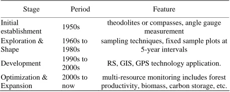
The Forest Continuous Inventory system includes the sam- pling method plot settings and survey index, time interval, and statistics and analysis etc. China’s work on the forest inventory system actually took place after 1950. It experienced 4 stages: 1) the initial establishing forest inventory system in nationwide in 1950s; 2) Sampling techniques using mathematical statistics as a theoretical basis from 1960s to1980s; 3) Remote sensing (RS), geographic information systems (GIS), global positioning sys- tem (GPS) technology was gradually introduced forest con- tinuous inventory technology from 1990s to 2000s; 4) The ex- pansion of inventory contents towards a multi-resource format includes forest productivity, biomass, carbon storage, etc. from 2000s to now.
The national inventory system only operates once every 5 years. Through the review of China’s forest resource continu- ous inventory of progress, to further improve the perfecting
forest continuous inventory system, how to improve the effi- ciency of inventory expanded inventory results application, some useful advice put forward in this paper.
China’s Forest Inventory System and Its Course
of Development
The Main Types of Forest Inventory
The forest inventory system and its contents, methods, tech- nology, form of results, etc. develop parallel to the rapid ad- vance of information technology and the widespread use of mathematical statistics. These new technologies and techniques enable integration of the macro-requirements of national for- estry construction and development with forestry production, and lead to the gradual establishment and perfection of man- agement practice requirements (Xiao, 2005).
After nearly 60 years of development, China’s large-scale forest continuous inventory took shape as a relatively perfect forest resource inventory system in view of the special charac- teristics and requirements of China’s forestry development. According to the research goal, content, and technical methods, China’s forest resource survey system can be divided into:
1) The nationwide forest inventory is referred to as a first class survey. Beginning in the 1970s, China’s forest continuous inventory was gradually established at the province level (re- gion, municipality), with the data from the provinces making up the main body of the overall forest Continuous inventory sys- tem. Every 5 years the inventory was repeated, using fixed sample plot surveys as the main method of carrying out regular monitoring. Within a unified time, and according to unified inventory requirements, a clear picture of the macroscopic
situation of national forest resources and its succession of pat- terns was created. This provided scientific evidence for the forestry development strategy and adjustment of forestry poli- cies in a timely and efficacious way. The national forest con- tinuous inventory used a systematic sampling method, and the stratified sampling method was integrated into the sampling estimation. For the systematically extracted samples a stratified sampling estimation was completed according to forest volume or other survey factors, the principle being to make the factor variation as small as possible for all points within the layer and larger between the layers, in order to improve the accuracy of stratified sampling estimations. In addition, in order to improve the efficiency of sample plot extraction, double samples and double regression method estimates are frequently used. This takes advantage of easily measured auxiliary tree survey factors to realize estimates of forest accumulation. When the forest resource inventory also has other spatial data sources, such as aerial or satellite imaging, the multi-source data joint estimation method is usually still adopted.
2) The forest management plan inventory is referred to as a second class survey. The Forest Management Plan Inventory is one kind of forest resource inventory method. It uses state- owned forestry bureaus, nature preserves, forest parks and other areas of forest management units or administrative units above the county level as its departments, and is carried out with for- est management sub-compartments as the basic unit. It is done once every 10 years, to provide evidence for the forest man- agement plan, the overall plan and county-level or above forest planning, and the sub-compartment data files which take shape provide a data platform for forest management and tasks.
3) The forest task planning survey is known as a third class survey. This inventory is a carried out as a task-based survey with a particular scope or operational area as the basic unit. Usually it adopts the real measurement or sampling inventory method. For the forest resources in each operational area, site conditions and forest regeneration status are used to undertake a detailed survey, with the goal of satisfying the requirements of specific production tasks (e.g. afforestation, deforestation, for- est tending etc.) arranged by basic level forestry production units, usually carried out in the production tasks of the previous year.
4) The annual special forest resource inventory is known as the verification survey. Its goal is to achieve a timely grasp of the situation regarding completion of the annual forestry pro- duction plan by forestry production units or project implement- tation units. It evaluates the effectiveness of forestry production assignments, so that the Forestry Department and other related departments can adjust their annual production plan, to provide a basis to boost the effectiveness of carrying out the Forest Management Unit’s forestry production plans. The verification inventory method usually takes a locality (city) or county (for- estry bureau) as its basic units, using the terrain verification survey method.
5) Specialized inventory. Specialized forestry inventory in- cludes site-type surveys, forest soil surveys, forest regeneration surveys, forest disease and pest surveys, preparation of forestry tables, forest growth surveys, forest multi-benefit measurement surveys and assessments, wild animal resource surveys, and other specialized inquiries. Its findings provide basic data di- rectly to main specialized surveys, district, planning, design and establishment of forestry production.
The Shape of the Forest Continuous Inventory
System
China’s work on the forest inventory system actually took place after the founding of the new China, beginning in 1950 (Yi, 1991). At that time, forest inventory technology from the former Soviet Union was comprehensively introduced. The Soviet technology was in reality originally from Germany, and in addition the previous knowledge in the country on forest inventory came from European and Japanese systems, so China’s technology was close to the European system from the beginning (Goran & Hans, 1998; Kleinn et al., 1998; American Forest Council, 1992).
Table 1 shows the 4 stages of shape and progress of China’s Forest Continuous Inventory.
In the early part of the 1950s, theodolites or compasses were principally used for measurement, and to regulate the survey area, using a grid method to divide the land into compartments and sub-compartments, set up banded standard plots, and mea- sure each tree’s diameter in the standard plot to calculate forest volume. Since the workload of the survey was too large, in the middle of the 1950s, aerial forest surveys were developed, along with aerial forest inventories and ground based compre-hensive inventories. By the end of the 1950s, angle gauge mea- surement technology was also introduced (Scott, 1947; Ware & Cunia, 1962), since the method was simple, accurate and reli- able, and it received a wide range of applications throughout the country. According to the needs of that time, year after year the whole country was surveyed piece by piece. Since there were many investigation methods in different areas, survey quality was not consistent, and the scope of the inventory was incomplete. The statistical calculation methods were also rather poor at that time and remained so until the early 1960s. In 1962 the Forestry Department, responding to the requirements of forestry production development, organized the provinces (re- gions, city) to further the development of statistical work in the forest resource inventory across the whole country. For the 12- year period from 1950 to 1962, all of the various forest resource survey data was systematized, statistically processed and finally brought into a nationwide summary.
During the 1960s, sampling techniques using mathematical statistics as a theoretical basis were introduced and large-scale experiments and measurement verification was organized. In terms of the survey’s accuracy, quality, benefits and other as- pects, remarkable results were achieved across the board. This laid the foundation for the sampling techniques we use in our forest inventories today.
In the 1970s, China began to explore a national forest con- tinuous inventory system. This was due to the consideration
Table 1.
The 4 stages of shape and progress of China’s Forest Continuous In- ventory.
Stage Period Feature
Initial
establishment 1950s
theodolites or compasses, angle gauge measurement
Exploration & Shape
1960s to 1980s
sampling techniques, fixed sample plots at 5-year intervals
Development 1990s to
2000s RS, GIS, GPS technology application. Optimization &
Expansion
2000s to now
[image:2.595.307.539.643.736.2]that the former survey methods were all independent investiga- tions and the results from before and after lack continuity and comparability. It was impossible to achieve precise information on trends of growth and decline of forest resources (Cunia & Chevrou, 1969; Newton et al., 1974). In 1973, the Ministry of Agriculture and Forestry (MAF) arranged a national forest con- tinuous inventory project in each province (region, city), de- veloping the administrative districts and counties (bureaus) as basic units in the inventory system. This was the first time since the founding of the new China that a comprehensive forest con- tinuous inventory was carried out in a relatively unified time scale and on a national scope (Taiwan temporarily excluded). In this inventory, through the establishment of a pilot program, the country’s forest continuous inventory utilized systematic sam-pling methods and hierarchical regression estimate methods. Beginning in 1978, this system was fully developed in every province (region, city). The forest continuous inventory system is in accordance with the systematic sampling principle. Fixed sample plots were set up at ground level, the diameter of each tree in the standard plot was measured, and at 5-year intervals there was a review. This kind of inventory system can accu- rately obtain the current conditions of forest resources and un- cover growth and decline trends. Regular patterns of resource development can be grasped, the effectiveness of resource ma- nagement can be analyzed, and predictions of resource devel- opment trends can be predicted.
Thus China became one of the earliest countries to set up a forest continuous inventory system. From the 1970s until today, seven forest inventories have been carried out. The surveying period was divided into the years 1973-1976, 1977-1981, 1984- 1988, 1989-1993, 1994-1998, 1999-2003, and 2004-2008. The 8th inventory is already underway.
The first country-wide forest inventory was the first forest continuous inventory with the counties (bureaus) as the basic units which reached a national scope (excluding Taiwan) since the founding of the People’s Republic of China. Its main focus was on ascertaining the current forest resource conditions. Star- ting with the second national forest continuous inventory, the inventory system used the province (district, municipality) as the basic unit rather than the county. In subsequent inventories a review of previous inventory data, a gradual perfection of methods, and unceasingly enriched survey indices can be seen. At the end of the 1970s systematic sampling technology was first deployed, and by the 1990s remote sensing (RS), geo- graphic information systems (GIS), global positioning system (GPS) technology was gradually introduced. Forest continuous inventory technology has shown continuous improvement. Be- fore the 5th inventory, priority was given to timber production. For the most part, traditional ground level sampling was under- taken on the sample plots at this time. The 6th inventory in- creased forest ownership, plant disease and insect pest con- tents, and comprehensively introduced remote sensing technol- ogy, with 3S technology as the foundation. It used remote sen- sory monitoring and ground surveying technology combined with the double stratified sampling remote monitoring system (Wang et al., 2007; Gregoire, 1993; Lyncii, 1995; Martin, 1982). At present, the 7th national forest continuous inventory has incorporated the forest’s ecological functions, forest healthy class and biodiversity into the measurement categories as re- flections of ecological status. The forest continuous inventory system is moving in the direction of development of a compre- hensive monitoring system for both resources and ecological
conditions (Xiao, 2005).
In the 1980s, China’s forest continuous inventory system was further improved, unifying the technological system for the en- tire country. As information technology developed, remote sen- sing technology began to be used during surveying, and satel- lite imaging and aerial sample plot imaging also made their ap- pearance. Within the statistical work of the inventory, unified survey factor coding and unified data storage formats came into usage. A complete statistical summary was entered into the computer system, guaranteeing the comparability and accuracy of survey results. This summary provides reliable basic data for the current national forest resource situation and its growth and decline status. In the area of sampling technology, an accurate two-stage and multi-stage estimation method for forest con- tinuous inventory was proposed (The Forestry Department of the People’s Republic of China, 1983).
Forest continuous inventories before the 1990s were mainly undertaken with the forest resources themselves as the focus. Beginning in the 1990s, the country began the development of the forest resource monitoring system. In 1991 the United Na- tions Food and Agricultural Organization provided China with aid projects in order to support the establishment of the moni- toring system. Research was begun on the establishment of a national Forest Resource Monitoring Body. This period of for- est resource inventory saw the beginning of widespread usage of 3S (remote sensing (RS), geographic information systems (GIS), the global positioning system (GPS)) technology, and improved investigative factors in the areas of forest ecology, health class, ownership and intensity of management (The For- estry Department of the People’s Republic of China, 1994).
After the year 2000, China gradually established a forestry development strategy that gives priority to ecological construc- tion. China’s “Forest Continuous Inventory Technical Regula- tions” (The Forestry Department of the People’s Republic of China, 2004; Arner et al., 2004; Cochran, 1997), issued in 2004, embody the survey indices of forestry development with a fo- cus on ecological construction. Beginning with the 8th national forest resource inventory, the surveying system will gradually develop into a comprehensive monitoring system which will give equal priority to the forest resources and the ecological si- tuation. There are 75 investigative factors for sample plots in the 8th inventory which can be divided into six aspects: land usage and coverage; site and soil; stand characteristics, forest function; ecological situation, and other forest land manage- ment related survey indices. At present the 8th national invent- tory is underway, and the comprehensive monitoring system projects are divided into six projects and 133 monitoring factors (Ye et al., 2000): such as land cover and land usage, soil and site, land degradation, forest function efficiency, wood and other forest products, forest health conditions and disasters, and biomass and biological diversity.
The Progress of Continuous Forest Resources
Inventory
system for national forest resources and the environment, and the State Forestry Bureau Planning and Design Institute com- pleted the overall design. In 1998, the compilation of the tech- nological plan and regulations was completed. On December 12, 2004, research was initiated on establishing a framework for a comprehensive monitoring system for forest resources and the ecological situation (Bu, 2005). The general ideas and basic framework for such a system were put forth. The monitoring of water, air and soil at a microscopic level can accurately assess the status of forest resources and lead to the discovery of regu- lar patterns of forest growth, and can also find the external fac- tors influencing natural forest growth. This environmentally- focused monitoring will represent a new direction of develop- ment for the comprehensive monitoring of forest resources, and also mirrors international development trends.
The characteristics of information on forest resources and ecological conditions come from many sources, and in many forms, shapes, grades and structures (Lie, 2006). Under the gui- ding idea of systemic integration, computer network technology, database technology, 3S technology, model simulation tech- nology, and resources will be comprehensively integrated. Es- tablishing a public service platform for comprehensive moni- toring of forest resources, and promoting the further develop- ment, application and integration of information resource for forestry development and ecological construction to provide a real-time, dynamic, open information service will improve eva- luation and forecasting ability to help avert disasters and ensure the success of engineering projects.
Remote sensing, aerial remote sensing, global positioning system, global information systems, database technology and computer network technology are widely applied in the mod- ernization of forest resource monitoring. In particular, the use of remote radar sensing data to carry out local surveys, such as coastal shelter forest surveys, has been gradually increasing.
The expansion of inventory contents towards a multi-re- source format includes forest productivity, biomass, carbon sto- rage, forest products, temperate area resources, desertification, rocky desertification of soil resources and wild animal and plant resources. The development towards a multi-benefit for- mat mainly includes investigation of the ecological conditions and functions of the forest, relating to sample plot biodiversity, forest health, and information output on ecological functions and forestry engineering effectiveness. Multi-resource, multi- benefit monitoring will guarantee comprehensive monitoring of the forest volume, quality, functions and benefits.
In recent years, due to China’s forest resource management requirements, each province hopes to have forest resource and ecological conditions information for every year. One key trend of variation in forest resource monitoring is how to use the 5- year cycle of forest continuous inventories to realize annual forest resource monitoring. The method mainly used is to add detail to the original inventory sampling grid and review every year. Due to the heavy workload and high costs this method is not adopted by many. Another method is to utilize the data from the inventory, and carry out an update using the growth and consumption model. A third method is to correct and con- trol the original inventory data through the use of remote sens- ing to provide annual data to combine with the original data (Roesch & Reams, 1999; Reosch et al., 1993; Scott et al., 1999).
In 1999 Zhejiang province took the lead in performing an annual forest resource monitoring trial taking the requirements
of the new situation into account. The method they adopted involves tightening the original forest inventory sampling grid and reviewing every year. Minor forest zones utilize modeling to update their data as an auxiliary method. Annual forest re- source monitoring not only improves the usefulness of the re- sults of the forest continuous inventory, but also provides an- nual forest resource data for resource management. Every year Zhejiang Province will make their annual monitoring of forest resources and ecological conditions into a public announcement, helping the society to understand the forest, and increasing public participation and enthusiasm for forestry.
Discussion
Modern forest inventory monitoring technology is not a sin- gle-source technology. Its development is also not an inde- pendent development of one branch of science. It is rather a comprehensive integration of many types of technology and even many different scientific fields (Zhu, 2001). At present, spatial remote sensing, aerial remote sensing, global positioning, global information systems, database technology and computer network technology, along with other high-technology products, have received different degrees of national usage in forestry (Wynne et al., 1999). Looking at each kind of technology in turn, it can be seen that ground surveying can’t satisfy the needs of a macroscopic analysis; aerial digital imaging has too large an information content to be useful in the monitoring of forest resources over vast areas; and satellite monitoring can’t satisfy the demands for level of detail needed in resource monitoring information. Therefore, as far as monitoring technology, it is necessary to organically combine ground surveying, aerial and satellite imaging as the information content, accuracy and time period requires. The technique of combining 3S technology and ground survey methods, promoting space/ground/sky-integrated monitoring, receiving information from many channels and on many levels, can be an effective forest resource monitoring method.
The rapid growth of the national economy and the need for sustainable forestry development has given rise to some contra- dictions. On the one hand there is a requirement for the conno- tation of forest resource inventory to broaden, resource data to be updated year by year, and to develop forest resource moni- toring in the direction of multi-resource comprehensive moni- toring. On the other hand, although the establishment of a forest continuous inventory system played a very important role in promoting digital forestry and has become an important foun- dation for forest resource management, people have questioned the spending of such enormous sums of money to develop for- est continuous inventories. How to further expand the sphere of application of the forest resource inventory results, and research low-cost continuous forest inventory methods remains a crucial research topic today.
continuous forest resource inventory, and there is no way to utilize the forest inventory system to directly provide data on annual forest resource status and growth and decline status. To this end, some specialists have proposed surveying 1/5 of the provincial sample plots every year, and leaving the remaining 4/5 to use data updating methods to take the place of annual ground surveys. But what is urgently needed to solve this prob- lem is 1) the basis for this statistical theory; 2) a method to extract 1/5 of the sample plots and 3) a concrete method to update the data for the remaining 4/5.
Moreover, the further integration of the forest continuous in- ventory and the second class (sub-compartment) forest resource inventory is also an important purpose of research in this paper. Under normal conditions, on the basis of the fixed sample plots usually used for the province level continuous inventory, the county level inventory sampling system can be established to act as a control on the sub-compartment survey precision. For this reason, realization of the data of the forest inventory can make the sub-compartment management more practical. The actual situation shows that costs and workload will be greatly increased by establishing such a system. Many counties have abandoned the increased-precision sample plot system that de- pends on county level data because it brings unavoidable prob- lems of precision control in sub-compartment survey. At the same time, new requirements have been put forward for the progress of forest ecology monitoring which use mountain mas- sif or even river basin areas (combined sub-compartments) as basic units. Some specialists (She, 1998; She et al., 2007) have proposed the varied probability sampling method with the county-level data making up the main body of data, and sub- compartments as the basic sampling unit (or combinations of sub-compartments). This proposal is directed at the existing problems in second-class forest resource inventory, specifically in the south of China. With this type of sub-compartment sam-ple plot a forest resource fixed angle gauge plot dynamic meas- urement system can be established in each province. At the same time, the statistical estimations of sub-compartment class sample plots can serve as a control on the precision of the entire second class forest (sub-compartment) inventory. This method not only uses the high efficiency of varied probability sampling established in the forest resource monitoring system, but also can combine the sampling estimation method with sub-com- partment inventory. This will satisfy the requirements of eco- logical inventory by region. Sub-compartment class fixed sam- ple plots can become a new forest resource monitoring system, according to the inventory being carried out.
First and second class forest resource inventories are both important components of the national and local forest resource monitoring system. The amount of sample plot data used in the nationwide province-based inventory estimates is rather large, and the corresponding workload and costs are prohibitive. On this basis it is suggested to establish a national forest continu- ous inventory system and sample plot monitoring system that takes the whole country as its basic unit. In this way, the amount of sample plots in each province can be greatly reduced, and also it will be beneficial to the development of an annual national forest inventory. At the same time the statistical data can control the precision of each province’s own inventory data collection. Each province’s continuous forest inventory can be implemented according to the method suggested above on a national sample plot basis according to the really existing con- ditions in the province, creating a more perfect forest resource
monitoring system. The new forest continuous inventory sys- tem Put forward by this paper not only can play a role in origin- nal system but also can realize two classes of survey combina- tion.
REFERENCES
American Forest Council (1992). Report of the blue ribbon panel on forest inventory and analysis. Washington DC: American Forest Council.
Arner, S. L., Westfall, J. A., & Scott, C. T. (2004). Comparison of an- nual invertory designs using forest inventory and analysis data. For- est Science, 50, 188-203.
Bu, C. J. (2005). Research of the country’s start of a framework for establishment of forestry resource and ecological condition compre- hensive monitoring system. Journal of China Forestry Industry, 1, 4. Cochran, W. G. (1997). Sampling techniques. Hoboken, NJ: John Wi-
ley & Sons, Inc.
Cunia, T., & Chevrou, R. B. (1969). Sampling with partial replacement on three or more occasions. Forest Science, 15, 204-224.
Goran, K., & Hans, T. (1998). The Swedish national forest inventory 1983-1987. Ultuna: Department of Forest Survey, Swedish Univer- sity of Agricultural Sciences.
Gregoire, T. G. (1993). Estimation of forest growth from successive surveys. Forest Ecology and Management. 56, 267-278.
doi:10.1016/0378-1127(93)90117-6
IUFRO, S4.02-05 (1994). International guidelines for forest monitoring. Vienna: IUFRO.
Kleinn, C., Dees, M., & Polley (1998). Forest inventory and survey systems in Germany. Bonn: Federnal Ministry of Food, Agriculre and Forestry.
Lie, X. Y. (2006). Forestry resources and ecological condition informa- tion resource integration structure analysis. Journal of Forest Re- sources Management, 2, 51-56.
Lyncii, T. B. (1995). Compatible estimation of components of forest growth from remeasured point samples with restricted generalized least squares. Forest Science,41, 611-628.
Martin, G. L. (1982). A method for estimating in growth on permanent horizontal points. Forest Science,28, 111-114.
Newton, C. M., Cunia, T., & Bickford, C. A. (1974). Multivariate esti- mators for sampling with partial replacement on two occasions. For- est Science,20, 106-116.
Roesch, F. A., & Reams, G. A. (1999). Analytical alternatives for an- nual inventory system. Journal of Forestry, 97, 33-37.
Roesch Jr., F. A., & Deusen, P. C. (1993). Control variate estimators of survivor growth from point samples. Forest Science,39, 66-77. Scott, C. B. (1947). Permanent growth and mortality plots in half the
time. Journal of Forestry, 45, 669-674.
Scott, C. T., Kohl, M., & Schnellbacher, H. J. (1999). A comparison of periodic and annual forest surveys. Forest Science,45, 433-451. She, G. H. (1998). Study on the applied theory and method of angle
measuring in volume growing estimation. Scientia Silvae Sinicae, 34,
25-30.
She, G. H., Lin, G. Z., Wen, X. R. et al (2007). Improvement of for- estry resources second class survey methods and the establishment of angle sampling monitoring system. Journal of Nanjing Forestry Uni- versity, 31, 11-14.
The Forestry Department of the People’s Republic of China (1983). Main technical regulations of forest resources investigation. Beijing: China’s Forestry Press.
The Forestry Department of the People’s Republic of China (1994). Main technical regulations of forest resources survey. Beijing: Chi- na’s Forestry Press.
The Forestry Department of the People’s Republic of China (2004). Main technical regulations of continuously forest resources inventory. Beijing: China’s Forestry Press.
Wang, Y. H., Xiao, W. F., & Zhang, X. Y. (2007). Forest health moni- toring and evaluation of the present situation and development trend domestically and abroad. Journal of Forestry Science, 43, 78-85. Wynne, R. H., Oderwald, R. G., Reams, G. A., & Scrivani, J. A. (1999).
Optical remote sensing for forest area estimation. Journal of Forest, 98, 31-36.
Xiao, X. W. (2005). China forestry resources inventory. Beijing: Chi- na’s Forestry Press.
Ye, R. H., Zhou, W. D., Huang, G. S. et al. (2000). A technical scheme
for national forestry resources and the ecological environment com- prehensive monitoring and system evaluation. Journal of Forest Re- sources Management, 3, 17-21.
Yi, H. Q. (1991). China’s forestry survey planning and design history. Changsha: Hunan Press.