Deliverable D2.1
Gaps and challenges for
addressing security threats in
urban environments
Editors
A. Belesiotis (ATH), D. Skoutas (ATH)
Contributors
N. Bakalos (ICCS), A. Belesiotis (ATH), J. Hellriegel
(FRAUNHOFER), F. Fuchs-Kittowski (FRAUNHOFER),
A. Litke (INF), N. Papadakis (INF), N. Papadakis (SPH),
S. Pfennigschmidt (FRAUNHOFER), S. Ruscher (SYN),
E. Sauli (SYN), D. Skoutas (ATH)
Version
1.4
Date
September 28, 2015
Distribution
PUBLIC (PU)
Executive Summary
This document surveys the state-of-the-art in the areas related to the City.Risks project. Our analysis starts by reviewing relevant complete and integrated solutions in the urban security landscape. A total of 22 projects and 46 software and hardware solutions have been analyzed. Most of these solutions constitute results of completed and ongoing research projects. The survey focuses on the use cases, target audience, solution types, software platforms and data sources employed in the analyzed solutions.
Then, we look into individual areas of research that are of relevance to City.Risks. This analysis focuses on highlighting the current advances and identifying relevant research that can be exploited or extended within the scope of the project. For every research area of focus, we outline the most important recent advances in relation to the City.Risks tasks. Furthermore, based on identified gaps and challenges in the state-of-the-art, we present research directions that can be exploited within the scope of the project.
The first relevant area of research we review is Emergency Response and Risk Management. More, specifically, we present the recent advances in emergency alerting and response, augmented reality, and risks management for decision support within the operation center. Then, we outline the most important work related to Data Management that is of relevance to City.Risks. We focus on data acquisition and mining, query processing, privacy and anonymization, data analytics and route planning. Our analysis continues with the areas of Mobile Sensors and Sensor Communication. We overview recent advances on sensor technologies and communications, we present current work in ground monitoring and theft detection, and we discuss relevant approaches for theft detection. Finally, we outline the state-of-the-art in software development methodologies, platform architectures, design process models and theories, and we overview platform architectures for emergency management systems.
This report is the first deliverable of WP2. The results of this study will serve as the foundation for the research and development tasks in WPs 3, 4 and 5.
Table of Contents
1. INTRODUCTION ... 6
2. URBAN SECURITY LANDSCAPE ... 8
2.1. Gaps and Challenges ... 8
2.1.1. Use cases... 8 2.1.2. Target audience ... 8 2.1.3. Solution type ... 9 2.1.4. Platforms ... 9 2.1.5. Data sources ... 9 2.1.6. Features provided ... 10 2.1.7. Dedication to standards ... 10
2.1.8. Gaps and challenges identified ... 11
2.2. Solutions Overview ... 11
2.2.1. Research fields ... 11
2.2.2. Rolled out applications ... 12
2.2.3. Ongoing projects’ development ... 14
2.2.4. Solutions in focus ... 16
3. EMERGENCY RESPONSE AND RISKS MANAGEMENT ... 27
3.1. Emergency Alerting and Response ... 27
3.1.1. Alerting ... 27
3.1.2. Response ... 30
3.1.3. Research directions ... 31
3.2. Mobile Augmented Reality (mAR) ... 31
3.2.1. User interaction with mAR data ... 32
3.2.2. mAR content models ... 32
3.2.3. Generation, provision and rendering of mAR data ... 33
3.2.4. Research directions ... 33
3.3. Risks Management and Operation Center ... 34
3.3.1. Risk management ... 34
3.3.2. Operation center ... 35
3.3.3. Simulation and visualization of crime and risks ... 36
3.3.4. Research directions ... 37
4.1.1. Mining the social media ... 38 4.1.2. Sentiment analysis ... 39 4.1.3. Event detection ... 39 4.1.4. Event summarization ... 40 4.1.5. Geocoding ... 41 4.1.6. Research directions ... 41 4.2. Query Processing ... 42
4.2.1. Identifying and ranking locations and areas of interest ... 42
4.2.2. Queries with spatial, temporal and textual filtering ... 44
4.2.3. Research directions ... 47
4.3. Privacy and Anonymization ... 47
4.3.1. Privacy issues and anonymization techniques ... 47
4.3.2. Research directions ... 49
4.4. Data Analytics ... 49
4.4.1. Mapping crime ... 50
4.4.2. Predicting crime ... 51
4.4.3. Crime analytics using the social media ... 51
4.4.4. Crime analysis software ... 52
4.4.5. Research directions ... 52
4.5. Route Planning ... 53
4.5.1. Shortest path queries in road networks ... 53
4.5.2. Generalised path queries ... 55
4.5.3. Generalised routing problems ... 57
4.5.4. Research directions ... 58
5. MOBILE SENSORS AND COMMUNICATIONS ... 60
5.1. Sensors and Communication ... 60
5.1.1. Communication technologies for wireless sensor networks ... 60
5.1.2. Network topologies and operational modes ... 61
5.1.3. Mobile wireless sensor networks ... 62
5.1.4. Coverage issues for MWSNs ... 63
5.1.5. Data management issues for MWSNs ... 64
5.1.6. Research directions ... 65
5.2. Ground Monitoring and Theft Detection ... 65
5.2.1. Location finding ... 65
5.2.2. Existing monitor systems ... 65
5.2.3. Collaborative target detection with decision fusion ... 66
5.2.5. Research directions ... 68
5.3. Mobile Sensing in City.Risks ... 68
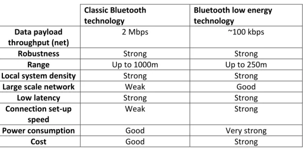
5.3.1. BLE relevant technologies ... 68
5.3.2. Bluetooth low energy technology overview ... 69
5.3.3. BLE fundamental characteristics ... 70
5.3.4. Beacons ... 72
5.3.5. Theft detection sensor technical consideration ... 74
5.3.6. Research directions ... 78
5.4. Existing Solutions and integrated projects related to City.Risks BLE theft detection sensor ... 78
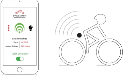
5.4.1. BluVision/CycleLeash concept ... 78
5.4.2. Bike Track concept ... 80
5.4.3. BikeTrack fundamental principles ... 80
5.4.4. BikeTrack platform components ... 81
5.4.5. Customized Bluetooth tag installed on bicycle... 81
5.4.6. Implementation of client app on mobile phone ... 82
5.4.7. Back-end software ... 82
5.4.8. Research directions ... 82
6. SOFTWARE DEVELOPMENT METHODOLOGIES AND PLATFORM ARCHITECTURES ... 84
6.1. Software Development Methodologies... 84
6.1.1. Design process models and theories ... 84
6.2. Platform Architectures for Emergency Management Systems ... 88
6.3. Research directions ... 91
7. CONCLUSIONS ... 92
APPENDIX I. ROLLED OUT APPLICATIONS ... 93
APPENDIX II. ONGOING PROJECTS’ DEVELOPMENT ... 99
1.
Introduction
The City.Risks project aims at increasing the perception of security of citizens in urban environments. This will be achieved by placing information sharing at the center of addressing security challenges in large urban environments. Citizens will serve both as targets and sources of information. Information flow will be bidirectional between citizens and authorities or among citizens themselves, forming trusted networks and communities. Smart phones and mobile devices will be utilized as the enabling technologies for the visualization and acquisition of information. The City.Risks platform will analyze and integrate diverse information including historical crime data, statistics, victimization reports, demographic data, maps of transportation networks, physical sensory data, news feeds and information mined from the Web.
The City.Risks project will have to address multiple challenges from different research areas. To do so effectively, we must exploit current research advances and extend the state-of-the-art to effectively complete the project tasks. The first step towards this direction is provided by this document, which overviews the most important work that is relevant to City.Risks. The analysis is conducted both at a project level and at the level of individual areas of research that are relevant to the City.Risks project.
The first part of this analysis focuses on the Urban Security Landscape and provides a structured analysis of complete projects and integrated solutions. In particular, a total of 22 projects and 46 software and hardware solutions are investigated. Most of these solutions are the result of relevant research projects. These are analyzed across a number of relevant dimensions. Depending on the use cases they serve, these solutions focus on different fields of crisis management. Depending on their target audience, they may cater for general public, governmental bodies, control center staff and public safety forces. Depending on their role, these systems may be designed to provide information, enable communication or collaborations. The study follows additional distinctions such as the platforms, data sources and the features offered by the analyzed solutions.
The second part of our analysis presents the state-of-the-art in the areas of research that are relevant to the City.Risks platform. For every identified relevant area, we outline the most important recent advances in relation to the tasks that must be completed during the duration of City.Risks. Furthermore, we present research directions that will be exploited based on gaps and challenges in the current work. Emergency Response and Risks Management is a research area directly related to the project. Of particular significance are the topics of Emergency Alerting and Response, Mobile Augmented Reality for emergency response and Risk Management. To that end, we analyze the technology-driven, psychological, sociological and organizational aspects of alerting. Emergency response is broken down and analyzed in the levels of response creation, monitoring and organization. With respect to Mobile Augmented Reality, we focus on user interaction with mobile augmented reality data, content models, and the generation, provision and
rendering of mobile augmented reality data. Finally, we overview important work associated with Risks Management, the Operation Centre, and the Simulation and Visualization of crime information and risks.
Another important area of research to the project is Data Management. Gathering information from various sources is vital to City.Risks, and to this end we outline the most important relevant work in Data Acquisition and Mining. We focus on mining information from the social media, performing sentiment analysis, detecting and summarizing events, and geocoding web documents. Query processing is also a very important topic with respect to City.Risks. We present the state-of-the-art in query processing, and particularly focus on query processing with data with spatial, temporal and textual characteristics, which are related to the types of data that must be efficiently managed by the City.Risks platform. Moreover, as some of the data City.Risks may deal with include potentially private information, we study the aspects of privacy and anonymization. In addition, we discuss data analytics methods for mapping and predicting crime, crime analytics using information from the social media, and we overview the state-of-the-art software used for crime analysis. Finally, we present work in route planning queries, which constitutes another key area of focus for the services we plan to develop in the course of the project.
The third research area of focus relates to the theft detection requirements of the City.Risks platform. This is the area of Mobile Sensors and Sensor Communication. We overview recent sensor communication advances and we discuss important aspects for Mobile Wireless Sensor Networks, such as network topologies, operational modes, network coverage and data management. Particular attention is given to the topics of ground monitoring and theft. We focus on the problems of location finding, collaborative target detection and public safety surveillance networks. Our analysis continues with the mobile sensing technologies that will be employed in the City.Risks project. In addition, we discuss important technical considerations for theft detection sensors, and we analyze relevant solutions related to the sensors that will be employed in City.Risks.
The final research area of focus is Software Engineering. Our analysis reviews current Software Development Methodologies and Platform Architectures that have been employed for the development of Emergency Management Systems.
This document is structured as follows. Section 2 overviews the Urban Security Landscape. Section 3 presents current work in Emergency Response and Risks Management. Recent advances in Data Management are provided in Section 4. Section 5 focuses on Mobile Sensors and Communication. Relevant Software Development considerations are discussed in Section 6. Finally, Section 7 summarizes and concludes the report.
2.
Urban Security Landscape
2.1.
Gaps and Challenges
For initial research in the City.Risks project, a total of 22 projects as well as 46 software and hardware solutions, partly results from aforementioned projects, were analyzed and structured in a catalogue for further investigation. This survey of existing works in this area emphasized on use cases, target audience, solution type, platform, data sources and addressed features of the solutions analyzed.
Due to lack of available demonstrators provided by the developers, no qualified statement could be given concerning usability and conformity with standards of the examined hardware and software.
It is also noted, that many products sold are not more than mere video cameras streamed to a command and control center of some kind. These were not included into the deeper analysis, as they would not have created any added value for the results.
2.1.1. Use cases
As expected, the majority of solutions are set out to tackle public safety and security threats. Nevertheless, different fields of crisis management are addressed by the solutions analyzed. These different emphases will be displayed in more detail.
A broad number of the use cases presented is set out to inform citizens or collect data from their end user devices, employing sensors in the devices or social media used. Descriptions of solutions, which focus on data collection and information distribution, state, that during the development a central focus of the research and development activities was oriented towards ethical, privacy and legal aspects. Nevertheless, no extensive statements on legal aspects or standardization activities taken into account are provided by the solution developers.
Other aspects of the development tasks for the solutions analyzed were, on the one hand, to guarantee mobility of the end users by directing and coordinating them through centralized communication headquarters, and, on the other hand, to support policy makers and their strategic decision making.
2.1.2. Target audience
The main target audience of the solutions can be divided into four major categories: the general public, governmental bodies, control center staff and public safety forces. The functionalities provided to them are described subsequently.
The general public is primarily addressed by information services and sometimes included into collaborative actions. Most solutions offer a communication channel to
deliver actions to be taken in accordance with the current emergency situation. When citizens have the chance to participate i.e. by reporting as a first responder, they are provided with established social media contact points (most commonly a Twitter Channel).
Governmental bodies and policy makers are normally provided with analysis and steering methods. An outstanding feature of the ISAR+ project prototype (http://isar.i112.eu/) is providing users with well-documented strategic planning tools.
Communication on various channels and real time information retrieval are the key selling proposition for control center solutions that were analyzed throughout the initial research. Common data sources for these solutions are social media or video data provided by first responders on site.
Public security and safety, especially police forces, are commonly addressed by ways to monitor suspicious behavior or to track down persons and objects. These solutions are most commonly based on video surveillance.
2.1.3. Solution type
The majority of solutions analyzed are proprietary systems, requiring special hardware to be installed (i.e. control center equipment). Those systems, which are set out to integrate citizen actions into the risk assessment and reduction, are built to be used on mobile devices, especially cell phones. The mobile solutions can be subdivided into three main solution types. First, using social media channels for interaction with citizens is suggested. Secondly, collection of mobile phone sensor data is employed. Thirdly, information is provided through proprietary web portals that can be accessed by mobile browsers.
2.1.4. Platforms
As stated before, most systems are proprietary solutions, requiring special hardware and platforms. Those products and services built for common electronic devices like desktop computers, tablets and smart phones are equally spread among operating systems. For desktop computers, this is primarily enabled by using web technologies, providing online solution to the end users, enabling independence from Windows, Mac OS or Linux based operating systems. If mobile applications are developed, they are at least built for Android and iOS. Only few solutions provide further apps for Windows Mobile and Blackberry operating systems.
2.1.5. Data sources
Public security and safety solutions show three primary sources of input data, being generated by end device users, being collected by the devices automatically or being based on statistical data. User generated data is most commonly collected using
social media data aggregation, but also through user reporting tools and knowledge wikis or encyclopedias, which allow citizens participation and expansion.
Automatically collected data includes mobility, traffic, text, audio and video data, either collected by the mobile devices of the end users or by sensors developed for specific purposes.
Besides the aforementioned solutions, which provide real time data, some solutions are built on previous results only. The sources included into these products and services are statistical data, maps, infrastructural information and counter measures definitions.
When analyzing data sources and usage, also the option of reuse of the data was investigated. Nevertheless, most solutions do not provide any of their data sets. Only few implementers offer partially access to data or knowledge generated. Those offers consist either of wikis that were setup during projects and deliverable documents, which were made publicly accessible, or an API to open data, that was used for the solution developed.
2.1.6. Features provided
Building on the data collected, the safety and security solutions analyzed provide diverse features to the end users. Those products and services built on automated data collection most commonly serve as surveillance and tracking tools, but also sometimes enable coordination or policy actions through data filtering, visualization and statistics.
Other solutions, which build on research result and/or end user generated data, are set out to observe crisis events, to communicate with persons affected and to steer public safety and security forces. They are built around a command and control center solution that connects to mobile clients, enabling the required communication in unidirectional or bidirectional ways. Unidirectional services are either gathering information from public reports and user data for deeper insight or communicate information to the persons in the field for coordination. Bidirectional on the other hand enable collaboration between the command and control center staff and the essential end users at the crisis hotspot, allowing interactive resolution through all affected players.
2.1.7. Dedication to standards
Even though a broad spectrum of solutions is analyzed throughout this initial research, there are hardly any standards addressed or incorporated in the descriptions of the products and services provided. Nevertheless, some research projects like ISAR+ (http://isar.i112.eu/) and INDECT (http://www.indect-project.eu/) report on implementation of their methods with respect to the European Convention on Human Rights, the European Union Charter of Fundamental Freedoms, the UN Convention on the Rights of the Child or the Finnish Personal Data Act.
Considering the fields of application of the solutions analyzed, some technical standards, like mobile communication, could be expected to be met by the systems, but in general they are not explicitly stated by the product and service providers. Only the two UK based solutions Crime Data Repository and Crime Map dedicate themselves to usage of data based on JSON standard.
2.1.8. Gaps and challenges identified
When considering the results of this initial research, some gaps in the development could be identified, which are closely related to the challenges to be faced during future development of the City.Risks environment. Collection of social and end user generated data should on one hand side be available to others generating leverage effects. On the other hand side, collection of personal data has to respect data security laws and privacy rights, with respect to the legal situation in the country of application.
Furthermore, a strong dedication to standards, especially communication and encryption should be considered in further research and development, preventing potential abuse and misuse of data collected and processed by the City.Risks solutions. This might contradict with the requirements for availability and desirable platform independency of the software to be developed.
Thus, one of the challenges of further research and development will be to find a balance between the aforementioned interest conflicts. Establishing the desired harmony between them will be part of further steps throughout the City.Risks project.
2.2.
Solutions Overview
A research has been conducted in order to find related practices which will shed some light on the previous and ongoing work in the field. In the following sections an overview of the current applications found is projected in various fields. Fields include status of the project, funded by any European program, business analysis and technical specifications. The following content is aggregated from the URLs attached to each solution found.
2.2.1. Research fields
For every project highlighted, basic information provided covers the name, a web link, the funding reference, the type of the developed solution, the platform it is built for and the role of the solution. Role describes the type of communication that is enabled through the solution. The Information role therefore represents unidirectional communication from organization to public, while Communication represents the inverse direction, from public to organization. As a bidirectional form of communication, Collaboration enables cooperation of public and organization
The developed solutions are then presented with a screenshot and a short description, followed by details on target audience, use cases, features and countries the solution was piloted in. In a further step, possible transferrable content is analysed with regard to the City.Risks needs. This covers mapping to the City.Risks use cases and description of data used as well as data reusability and currently available access to the application. User and terms of use explains the user access to the solution, differentiating between active users, using the application as a tool to gather data and communicate, and passive users, who are restricted to viewing (limited) content. Furthermore, it is indicated, whether licences are granted by the provider.
In a final section of the analysis, further information is provided. This covers the international scale and scalability of the solution, the availability of support documents, like guidebooks or manuals, and indications towards international standards that are respected by the solution.
2.2.2. Rolled out applications
Furthermore, the following finished projects, products and services that are built not only for mobile usage, but also to work on other hardware systems, were explored during the initial research phase. For more detailed information refer to Appendix I.
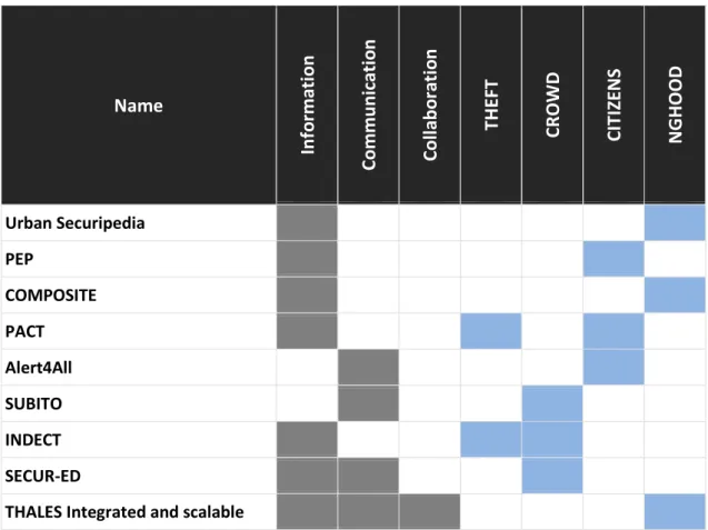
Table 2.1: Rolled out solutions mapped into communication directions and City.Risks use cases
Name In fo rm ati on Co m m u n icati o n Co lla b o ra ti o n THEFT CROW D CI TI ZEN S NG HO O D Urban Securipedia PEP COMPOSITE PACT Alert4All SUBITO INDECT SECUR-ED
urban security solutions
SAMSUNG Urban Security Systems SAAB SAFE Emergency Response Selex ES Urban Security Video Surveillance
Selex ES CITIESvisor TAS-AGT Urban Security LL Tech International Urban Security
ISS SecurOS ARMOR
Emexis Fuel Tracker CrimeReports UKCrimeStats
Crime Map Vienna - Kriminalität in Wien
Durham Crime map iSAR+ Opti-Alert VirtualGuard BluCop HappstoR iHound GadgetTrak Prey
Comodo Anti Theft SafeCity
Legend: THEFT: Theft of personal items
CROWD: Criminal activity in crowded areas CITIZENS: Assisting and engaging citizens NGHOOD: Neighbourhood safety
The solutions found are analysed through the communication direction (grey) and the pre-elementary use cases (blue) defined so far from the City.Risks project. The
previous section (Section 2.2.1). In addition, we map the analysed solutions with respect to the use cases that we plan to investigate within the City.Risks project. The complete specification of these use cases will the result of Task 2.4 and will be reported in the Deliverable D2.4. This mapping provides a deeper insight on the feasibility of future adaption of elements of the proposed solution into City.Risks components.
2.2.3. Ongoing projects’ development
Projects, that were of interest during initial research, but not finished before the delivery date of the current document, are listed below. Their results will be monitored throughout the further research and development processes of the City.Risks project. For detailed information refer to Appendix II.
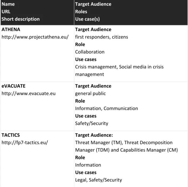
Table 2.2: Ongoing projects in the field of urban security
Name URL Short description Target Audience Roles Use case(s) ATHENA http://www.projectathena.eu/ Target Audience
first responders, citizens
Role
Collaboration
Use cases
Crisis management, Social media in crisis management eVACUATE http://www.evacuate.eu Target Audience general public Role Information, Communication Use cases Safety/Security TACTICS http://fp7-tactics.eu/ Target Audience:
Threat Manager (TM), Threat Decomposition Manager (TDM) and Capabilities Manager (CM)
Role
Information
Use cases
HARMONISE
http://harmonise.eu/
Target Audience:
Mechanisms/Tools for Delivery of Improved Urban Security and Resilience
Role
Information
Use cases
Safety/Security
Urban Security eGuide (Inspirational Plattform)
http://www.besecure-project.eu/dynamics//modules/ SFIL0100/view.php?fil_Id=56
Target Audience:
Education, community, general public
Role Information Use cases Safety/Security Policy platform http://www.besecure-project.eu/dynamics//modules/ SFIL0100/view.php?fil_Id=57 Target Audience: Policy makers Role Collaboration Use cases Safety/Security, Policy
Urban security Early warning system http://www.besecure-project.eu/dynamics//modules/ SFIL0100/view.php?fil_Id=58 Target Audience: Policy makers Role Information Use cases Safety/Security, Policy
iRISK Urban Vulnerability Measure http://create.usc.edu/sites/defa ult/files/projects/sow/1045/kur bancreateyear8annualreportkur banhudoc.pdf Target Audience:
NC state policy makers, Howard University students
Role
Information
Use cases
Economic, Social, Safety/Security
RAW Risk Assessment Workbench
http://create.usc.edu/sites/defa ult/files/projects/sow/850/hall2
005-Target Audience:
classified, “official use only” or public environment
Role
Information
Safety/Security DPS Deploy http://create.usc.edu/researche r/michael- orosz/projects/dpsdeploy-usc- department-public-safety-risk-assessment-and Target Audience:
USC Department of Public Safety
Role Information Use cases Safety/Security MobEyes http://lia.deis.unibo.it/Research /Mobeyes/ Target Audience: urban monitoring Role Information Use cases Safety/Security, Mobility 2.2.4. Solutions in focus
1. iSAR+
Online and Mobile Communications for Crisis Response and Search and Rescue
URL Project reference Solution type Platform Role http://isar.i112.eu/ FP7, Agreement no 312850
Document | Web | Mobile | Other Compatible with all mobile OS
Information | Communication | Collaboration
Short Description
iSAR+ is a research and development project aiming to definene the guidelines that, in crisis situations, enable citizens using new online and mobile technologies to actively participate in response efforts, through the provision, dissemination, sharing and retrieval of information for the critical intervention of Public Protection and Disaster Relief (PPDR) organisations, in search and rescue, law enforcement and medical assistance operations. From 2013 to 2015, the FP7 iSAR+ project addresses Theme SEC-2012.6.1-3: Use of new communication/social media in crisis situations.
Results
iSAR+ Guidelines - recommendations for citizens and PPDRs for an effective and efficient use of social media and mobile technology in crisis situations. iSAR+
Technological Platform - platform integrating ICT tools, including mobile and social media applications, that provide added-value services for citizens and PPDRs in crisis situations. Based on the citizens’ and PPDRs’ recommendations, the platform is a validation tool for the iSAR+ Guidelines.
Application technical details
Business analysis
Target audience Public Protection and Disaster Relief, search and rescue, law enforcement, medical assistance, general public
Use case(s) 1) Unattended baggage, 2) Metro Station Fire, 3) Toxic Gas Accident, 4) Plane Crash, 5) Thunderstorm
Feature(s) Social media and mobile data aggregation and presentation, information channels.
Pilot(s) France, Finland, Ireland, Norway, Poland, Portugal, United Kingdom
City.Risks Use Cases Theft of personal items | Criminal activity in crowded areas | Assisting and engaging citizens |.
Neighbourhood safety
Data usage
Source(s) of data Social Media and Mobile Data Data reusable Yes | No
Access to application
User and terms of use
User entrance Registered | Open access | Free | Commercial User passive Registered | Open
User active Registered | Open
License None
Additional information
Scale International
Supporting documents Yes | No
Deliverables
Indication to standards Yes | No | Not clear
Finnish Personal Data Act
2. Opti-Alert
Enhancing the efficiency of alerting systems through personalized, culturally sensitive multi-channel communication
URL Project reference Solution type Platform Role http://www.opti-alert.eu/ FP 7, Agreement no. 261699
Document | Web | Mobile | Other Compatible with all mobile OS
Information | Communication | Collaboration
Application snapshots
The Opti-Alert project is aimed at raising the efficiency of alerting systems through personalized, culturally sensitive multi-channel communication. Funded by the European Commission, Opti-Alert involves research institutes, universities, enterprises, and end-users from six European countries. The goal of the project is to create an adaptive alerting system that allows intuitive, ad-hoc adaptation of alerting strategies to specific alerting contexts. Opti-Alert will also facilitate improved regionalization and personalization of warning messages, as well as a closer cooperation and integration of industry-funded alerting systems with state-funded alerting tools. The project objectives will be pursued by the following key research activities:
In-depth analysis of the effect of social, cultural and regional factors on risk perception and risk communication
Analysis of the influence of the observed socio-cultural differences on regional alerting strategies
Analysis of the impact of individualized alerting (by SMS, e-mail etc.) and alerting through broadcast media
Identification of best practices in alerting through broadcast media
Definition of algorithms to simulate alert propagation in the population, both at large and inside critical infrastructures such as metro stations, as a function of interpersonal communication patterns and the selected mix of alerting channels. Results
The main results of this projects are: an Alerting Strategy Simulation, Channel and Broadcast Suggestion, and Media Broadcasting
Application technical details
Business analysis
Target audience General public
Use case(s) Safety and Security
Feature(s) Alerting Strategy Simulation, Channel and Broadcast Suggestion, Media Broadcasting
Pilot(s) Austria (Eastern Tyrol), Germany (Berlin), Italy (Eastern Sicily), Germany (Lippe)
City.Risks Use Cases Theft of personal items | Criminal activity in crowded areas | Assisting and engaging citizens |
Neighbourhood safety
Data usage
Source(s) of data Current emergencies from national authorities
responsible for alerting, weather alerts, disaster alerts, commercial alert through service providers
Access to application
End product published Yes | No
User and terms of use
User entrance Registered | Open access | Free | Commercial User passive Registered | Open
User active Registered | Open
License Not known
Additional information
Scale International
Supporting documents Yes | No
Deliverables
Indication to standards Yes | No | Not clear
3. iHound
iHound Phone & Family Tracking Platform
URL Project reference Solution type Platform Role https://www.ihoundsoftware.com/ No reference
Document | Web | Mobile | Other IOs, Android
Information | Communication | Collaboration
Short Description
iHound uses the GPS and WiFi, 3G, or Edge signals built into your devices to determine its location. Using the app and iHound Software's unique tracking website, you can Track the location of your device, Remotely Lock Your Phone, Remotely Wipe Private Information, Directly Instant Message Your Phone, Set up Geofencing Location Alerts, Manage your account using iHound's Mobile Web Site.
With iHound Geofencing automatically one can:
Get alerts when your child arrives at or leaves school.
Broadcast your arrival at the bar to your adoring Facebook and Twitter followers. Check-in with Foursquare to help you compete more effectively and become Mayor. Receive reviews of local restaurants when you arrive at your vacation destination. Have your shopping list delivered in an email when you get to the store.
Know where your loved ones are all the time, any time.
Application technical details
Business analysis
Target audience General public
Use case(s) Safety, Security, and Mobility
Feature(s) Geofencing, Location Tracking, Location Sharing, Push Alert with Sirens
Pilot(s) Not known
Neighbourhood safety
Data usage
Source(s) of data User data, location based information Data reusable Yes | No
Access to application
End product published Yes | No
User and terms of use
User entrance Registered | Open access | Free | Commercial User passive Registered | Open
User active Registered | Open License Commercial licence
Additional information
Scale International
Supporting documents Yes | No
Indication to standards Yes | No | Not clear
4. GadgetTrak
Leading innovator of theft recovery and data protection solutions for mobile devices URL Project reference Solution type Platform Role http://www.gadgettrak.com/ No reference
Document | Web | Mobile | Other iOS, Android, Win
Information | Communication | Collaboration
Short Description
GadgetTrak Laptop Security
Think about the things you have on your laptop right now: Countless photos, financial records, software, music, videos, etc. The hefty price tag on your laptop is probably dwarfed by the value of the information on it. The really scary part is that according to the FBI, 1 in 10 laptops purchased today will be stolen within the next 12 months. Sadly, only 3% will be returned. GadgetTrak dramatically increases the likelihood of finding your laptop, by pinpointing its location, and even sending a photo of thief.
GadgetTrak Mobile & iOS Security
What if your device was lost or stolen, what would it mean to your or your business? Not only is it the loss of an expensive device, but also your data, which can be priceless. GadgetTrak Mobile Security helps mitigate the risk of mobile device loss or theft, empowering you to track its location, back up data, even wipe the device.
Results
GadgetTrak is offering 3 types of security products laptop security, Mobile Security and iOS.
Application technical details
Business analysis
Target audience General
Use case(s) Laptop security, Mobile security for data loss and antitheft
Feature(s) Tracking, Memory Erasure, Wi-Fi positioning, Integrate police reports, webcam support, privacy safe, Advanced hybrid positioning, device alarm, Secure encrypted backup, Remote data wipe, Tamper proof
Pilot(s) Not known
City.Risks Use Cases Theft of personal items | Criminal activity in crowded areas | Assisting and engaging citizens |.
Neighbourhood safety
Data usage
Source(s) of data User data, location based information Data reusable Yes | No
Access to application
End product published Yes | No
User and terms of use
User entrance Registered | Open access | Free | Commercial User passive Registered | Open
User active Registered | Open License Commercial license
Additional information
Scale International
Supporting documents Yes | No
Wiki, FAQ and Knowledge Base
Indication to standards Yes | No | Not clear
5. SafeCity
Handy tool to geographically mark and report a safety issue faced by women and children URL Project reference Solution type Platform Role https://play.google.com/store/apps/details?id=com. phonethics.safecity No reference
Document | Web | Mobile | Other iOS, Android
Application snapshots
Short Description
Safe City is a handy tool to geographically mark and report a safety issue faced by women and children. You can quickly locate, identify and pin the issue on the map of your city. It is aimed at creating a social response system where this information is actively pursued in reaching out to the person in need and bring to the notice the issues and their causes so they can be addressed and monitored.
Application technical details
Business analysis
Target audience General public
Use case(s) Safety, Security, and Mobility
Feature(s) Location, Danger Spotting, Search
Pilot(s) Not Known
City.Risks Use Cases Theft of personal items | Criminal activity in crowded areas | Assisting and engaging citizens |.
Data usage
Source(s) of data User data, location based information Data reusable Yes | No
Access to application
End product published Yes | No
User and terms of use
User entrance Registered | Open access | Free | Commercial User passive Registered | Open
User active Registered | Open
License None
Additional information
Scale International
Supporting documents Yes | No
3.
Emergency Response and Risks Management
This section summarizes the most important work from the literature that is related to emergency response and risk management services and applications envisaged for the City.Risks platform. We describe recent advances in emergency alerting and response, augmented reality, and operation center and risks management. Furthermore, we pinpoint gaps and challenges in current work to outline specific research directions that will be explored within the scope of the City.Risks project.
3.1.
Emergency Alerting and Response
City.Risks uses different means of information sharing to address security challenges in large urban environments. The main goals of the project are to improve handling of safety and security challenges by integrating the public through mechanisms of participatory urbanism, and making safety-related information more transparent in order to reduce fear of crime of citizens.
Targeted emergency alerting and response play a major role in this context. Within this scope, the following sections focus on communication between authorities and the public. Alerting and response communication used by professional has not been considered here.
3.1.1. Alerting
After the end of the "cold war", investments in alerting systems for the general public were reduced in many European countries. As a consequence, the previously existing alerting infrastructure (sirens in particular) was either dismantled, or its coverage and / or availability decreased due to lack of maintenance. In the meantime, authorities mainly relied on mass media (TV, radio) to close the gap on the last mile when alerting the public. More recently, however, attempts have been made to use other technologies to communicate with citizens in emergency situations. This relates both to single-channel approaches (like cell broadcasting (Jagtman et al. 2010), which is currently the preferred solution in the Netherlands), or multi-channel alerting systems which combine, for example, SMS, e-mail, and RSS feeds (Klafft et al. 2008).
Efficient alerting encompasses aspects of the following categories. - technology-related aspects
- psychological and sociological aspects - organizational aspects
Many of these aspects are interrelated; technology influences how we perceive alerts, and organizational aspects influence whether we trust emergency information received.
Technology-driven aspects. According to Klafft (Klafft 2013) a lot of research has been conducted to analyze the first two steps of the alerting process, namely, sending and receiving messages. The following technologies are being used.
- cell broadcasting - SMS and pagers
- push infrastructures for mobile phones - twitter
- rss feeds, email, fax
- others, e.g., tv or radio broadcasts, sirens, sound trucks (not considered) Cell broadcasting. All available mobile communication standards (GSM, UMTS, LTE) define broadcast or multicast services. Broadcast services have the advantage of reaching an affected public without the need of a subscription service. On the other hand, messages are not explicitly called for and cannot be personalized, which reduces acceptance. While GSM cell broadcast is actually available and being used for distributing emergency information in some countries (e.g., US, Japan, or the Netherlands) usage of these broadcast services is limited, due to the lack of the necessary infrastructure. Beyond emergency alerting there are currently no real business cases, and mobile communication providers shy away from investing into these technologies.
SMS and pagers. SMS and pager technology have been used as a means for efficient personal alerting, since the advent of mobile communication networks. Pager communication requires specific devices and separate infrastructures, which limits its usefulness for alerting the public. In contrast, SMS can be used by (almost) any mobile phone, and is one of the most widespread technologies used for public alerts. However, both technologies offer limited information capabilities as they support only short messages, which is, why they are being more and more replaced by IP-based push infrastructures for smartphones.
Push infrastructures. One of the main technologies currently used for alerting are smartphone Apps providing push notifications. All major smartphone platforms provide a push service infrastructure (e.g., Apple Push Notification Service (APN), Google Cloud Messaging (GCM), Windows Notification Service (WNS)). Push notifications have the advantage over SMS that they are bound to a smartphone App that can directly load additional information related to an alert, thus giving a user details on what happened where, and on how to react. Another advantage of alerting Apps is that alerts can be subscribed to in a very dynamical manner, using, for instance, location information.
Twitter. In 2013 Twitter launched the service Twitter Alerts. Tweets that are marked as an alert are being actively pushed to all users subscribed to alerts of the issuer of a tweet. That means, subscriptions are based entirely on the who is providing an alert. Twitter-based alerts cannot be personalized or targeted to specific needs or user groups. The service is being used, for instance, by the Federal Emergency Management Agency FEMA in the US (fema.org) or the WHO Regional Office for Europe (euro.who.int).
RSS feeds, email, fax. All of these technologies have more or less been replaced by other means. Today, RSS feeds are no longer being used for actual alerting but for reporting emergency cases, e.g., for earth quake information. Also today, email and fax are playing only minor roles in alerting the public.
Others. TV or especially radio broadcasts have long been the only means to distribute detailed emergency information. Also these technologies lack the ability to target and personalize alerts. New digital broadcast standards (e.g. DAB+), however, provide means to distribute alerts similar to GCM cell broadcasts. Devices to receive and display such alerts are available but not actually widely used. In recent years, so-called smart TVs are being more and more available, which means that Apps and push notifications can be used with this medium, too.
Psychological and sociological aspects. Psychological and sociological aspects (as addressed, e.g., by EU project OptiAlert (http://www.opti-alert.eu) are a more or less disregarded topic in existing alerting systems. These aspects address the following questions.
- was an alert read
- was an alert understood
- was an alert reacted upon (see Sec. 3.1.2)
None of these questions can be easily answered by just using the right technology. Even actually displaying alert information on a device does not mean a user has read it much less understood its impact. Often, understanding problems arise from the information being delivered in a single language. Since responsible parties most often require an alerting system to be generic, alerts are not always built from pre-defined pre-translated building blocks but using free text input. Automatic translation can help that information is roughly understandable, but is not good enough to ensure that the information is being trusted. Trust, however, is the main point in bringing a recipient to react upon an alert. Trust builds itself on different components. The source itself needs to be trusted. It must be clear to the user that the message actually comes from that source and has not been tampered with. The contents of the message need to be verifiable, preferably using secondary sources (e.g., social media, online news, radio or TV broadcasts). Last, not least, users need to have the sense, that they are actually affected and need to react. Individualized and situation-related alerting is of major importance.
Organizational aspects. Emergency alerting for the public, usually, encompass information about different types of hazards (e.g., weather, floods, civil protection, crime, or defense). In most cases responsibilities for alerting the public about such hazards are distributed between different authorities.
On the other side, emergency situations often arise from a series of interconnected and dependent severe events. Alerting the public in such a situation requires a consistent voice which in turn requires a distributed incident management. Also emergency situations do not stop at political boundaries, so coordination of cross border alerting strategies (see OptiAlert (http://www.opti-alert.eu)) is of major importance.
These problems are much more pronounced in federal environments, e.g., in Germany (where the responsibility for civil protection is divided between ca. 400 individual counties).
3.1.2. Response
Appropriate response is the ultimate goal of all alerting systems, be it that people look for a safe place, secure their property, help others, inform others, or just stay informed themselves about their situation. The following section focusses on collaboration and organizing response between authorities, professional emergency relief organizations, and the public.
Three main categories or levels can be used to distinguish approaches to emergency response with focus on the public.
- creating response - monitoring response - organizing response
Creating Response. Creating response encompass all measures taken to ensure an alerted public actually takes action. This overlaps with the issues on psychological and sociological aspects of alerting presented above.
Monitoring Response. Monitoring tries to observe behaviour of the affected public and to verify users respond (correctly). In this case sentiment analysis techniques play a major role. Social media content streams the data items of which are tagged with temporal, spatial or keyword-based metadata is processed in order to get information how an emergency situation is perceived and reacted upon.
The role of social media (read twitter) in effectiveness of warning response (with focus on extreme events) has been studied in (Tyshchuk 2012). Twitter users seem to engage in all six stages of the warning response process (receiving, understanding, trusting, personalizing, obtaining confirmation, taking action).
Enhancing situational awareness through the use of microblogging (read twitter) has also been the focus of (Vieweg et al. 2010) and (Starbird and Palen 2011).
Organizing Response. Organizing response takes additional steps to facilitate collaboration between authorities, emergency relief organizations, and the public, through direct or indirect communication.
Effective response and recovery operations through collaborations and trust between government agencies at all levels and between the public and nonprofit sectors has been studied by (Kapucu 2005) and (Kapucu 2008). Key aspects of the relationship between volunteers and formal response organisations in disasters are presented by (Barsky et al. 2007). (Chen et al. 2008) proposes a framework to analyze coordination patterns along the emergency response life cycle.
Several systems have been developed to help coordinate responder communication and response efforts in order to minimize the threat to human life and damage to property. Examples include the ENSURE (http://ensure-projekt.de/) project and
(Yuan and Detlor 2005). Another flavour of systems around cooperatively responding to "threats" is community-based neighborhood watch systems.
One measure that sticks out of this category is running disaster exercises. Disaster exercises can also be seen as a means to create the right response in an emergency situation, it, however, needs a complete other level of organization and direct collaboration between authorities and citizens then the measures addressed above. The role of such exercises to improve effectiveness in emergency management and in creation of community disaster preparedness, has been laid out by (Perry 2004). Exercises result in increased knowledge of the participants (what to do in an emergency) as well as increased confidence in abilities of others and in the ability to work as a team.
3.1.3. Research directions
In contrast to broadcasting, targeted alerting requires information about the situation of the group or individuals to target. One of the challenges is to preserve the privacy of the users. There are different techniques that can be used to achieve this.
Pseudonymization of data records, using random device identifications instead of personal user ids, like, email addresses
Encryption of data records, e.g., using Bloom filters to guard against unauthorized access while maintaining searchability of data sets
Decentralized storing of data records, e.g., using personal or on device space to hold sensitive data
Since City.Risks tries to target a wide spectrum of use cases, alerting and – in particular – response functionalities require a lot of flexibility. In most cases, great flexibility leads to losses in scalability and overall performance of systems. To prepare City.Risks platform components to be used in real products, these flexibility/performance trade-offs has to be taken into account, to be able to serve huge number of users simultaneously as a smart city environment requires.
3.2.
Mobile Augmented Reality (mAR)
The City.Risks mobile application offers new visualization methods for communicating (individual) risks as an effective innovation for better action advices by integrating and developing mobile augmented reality (mAR) technologies. This mobile application with augmented reality features will allow citizens to use their smart phones or tables to visualize security-related information regarding their surroundings (e.g. historical crime statistics or any ongoing criminal activity), being also able to interact with the augmented objects (e.g., for tagging them). This will enable better situation-awareness and response support.
3.2.1. User interaction with mAR data
Mobile augmented reality (mAR) is an innovative user interface for providing individual risk information and warnings as well as action advices on mobile devices (e.g. smartphones). Individual risks and defence action alternatives can be presented more realistic, e.g. by presenting the virtual water level of flood (risk map) or potential danger defence actions (alternative kinds of level) directly in reality, which improves the individual recognition and analysis of a hazard situation as well as possible action possibilities.
The data presented as augmented reality can include information about visible objects (e.g. the statics of a building), not visible objects (e.g. a below-ground infrastructure like electricity or sewage system) or not yet visible objects (e.g. a flooding). For example, users can see information about their surrounding location regarding history of criminal activity (crime maps by type and seasonality), as well as any ongoing criminal activity or a coming criminal activity in the near future (e.g. a group of terrorists moving to the users location).
Today, mAR applications only present information (often 3D objects) to the user. But in case of an ongoing or future criminal activity (like in City.Risks), the communication should turn to a bidirectional channel, with the users (witnesses) sending back feeds to the authorities. The challenge is to provide users the possibility to interact with the augmented objects, e.g. to add information, to update objects or to create new objects. Similarly, methods and tools for capturing of new content by the users (crowd sourcing, in-situ authoring) are not available (research is focused on authoring tools for expert authors, e.g. DART, arToolkit, Layar Creator) (Chun et al. 2013) (Rumiński et al. 2013); thus, research will be conducted in the field of design of interaction with spatial mAR content.
3.2.2. mAR content models
Traditionally, only a single risk is presented as AR in a mobile application. An additional challenge that will be addressed in the City.Risks project is to visualize a set of (all) risks (historical as well as current as well as future) in a single mobile app. Different data sources (data bases, web services, GIS etc.) with different data types and formats will be integrated and mapped to a common content model (Rumiński et al. 2014). Unfortunately, no standard AR data format currently exists.
Current mAR content standardization (OGC ARML 2.0 (Lechner 2013), AR Standards (Perey 2014), AREL (Metaio 2014) and X3D AR (SRC WG 2013)) do not address the problem of a common content model for a consistent mapping and management of heterogeneous content from different data sources, because they only focus on a data format for visual presentation of mAR content. Therefore, research for such a common data exchange format is necessary and different available data formats have to be investigated to develop such a common data exchange format.
Another challenge is the integration of spatial data, its combination with additional data, and the subsequent generation of appropriate 3D structures. Most promising is the XML-based OGC standard CityGML as such a mAR data exchange format. Hereby,
the spatial data objects (as connecting elements of the real environment as well as the augmentation) could be mapped with its structure, geometry and semantic in appropriate structures of the standard CityGML (Gröger et al. 2012) which could be transformed in an appropriate 3D structure: mapping of the actual geometry (e.g. for building); representation be (realistic) symbols (e.g. vegetation); approximation by extrusions. These information can be combined with other spatial data (e.g. aerophoto for texturing), so that from the existing spatial data sets result comprehensive descriptions for the mAR Scenes.
The use of the standards CityGML probably enables – besides the mapping of the geometries – also the preservation of the structure of the objects and the mapping of the semantic, which can be used as a basis for the subsequent scene authoring. The building of the 3D structures will take place rule-based, c.f. to the greatest possible extent automatically.
3.2.3. Generation, provision and rendering of mAR data
The information provided to the citizen about the individual risk at a certain location can be static (maps, crime statistics) or dynamic/real-time (current events, conditions). As relevant data (e.g. real-time crime maps, flood risk maps) can be complex geometries, existing approaches of web services for data generation, provision and rendering for mAR on mobile devices (Belimpasakis et al. 2010) are made for static data and are based on caching (e.g. tile map services, TMS), which are too inflexible in dynamic danger situations (storage use, performance, user experience UX).
A challenge is to provide dynamic complex mAR data in real-time. The main approach will be to develop a dynamic, cloud-based, OGC conform Web Processing Service (WPS) within the existing holgAR content platform (Fuchs-Kittowski et al. 2012), (Fuchs-Kittowski et al. 2014) for providing data necessary, that uses clipping to reduce the complexity of a polygon (e.g. risk map). By clipping, a specific area is cut out of a risk map to create a smaller map (a less complex geometry with less data to process). This way, the generated geometry is small enough to be rendered on demand dynamically. In addition, outsourcing resource intensive tasks to the cloud (e.g. Google App Engine) (Huang et al. 2014), (Manweiler 2014) will be used to ensure a high performance, reliable and robust system in case of a disaster, where a large number of requests are expected.
3.2.4. Research directions
During the design of the City.Risks mobile application, we direct our research to new and vibrant topics related to the use of augmented reality in security solutions.
Development of a mAR data description language (mAR content model): As a basis for a consistent, neutral representation of spatial content from different data sources in different formats a mAR content description language will be developed.
ranging from simple formats (e.g. points of interest) to complex objects (2D area, 3D structures etc.), e.g. AREL for presentation in AR browsers. The technical basis will be the XML-based standard CityGML, which is well established in the world of spatial data and will be investigated and probably used in the project. Particularly, CityGML provides a good basis for the description of geometries and semantic and is – as a generic language – extensible, e.g. for flood, crime and other risks.
Development of mAR dynamic, cloud-based WPS: Development of a dynamic, high-performance, cloud-based, OGC conform Web Processing Service (WPS) for the generation and provision of dynamic mAR representations in real-time. It will use techniques like clipping to render a complex geometry (e.g. a risk map) on demand dynamically, and will be implemented as a cloud service to ensure a high performance, reliable and robust system in case of a risk, where a large number of requests are expected.
Development of an user interaction concept for spatial mAR content: An interaction concept for spatial mAR content will be developed and implemented to present actual risk information as mAR in the camera view of the mobile device in the context of reality and allow the users to interact with it. It will provide users of the mobile app the possibility to interact with the virtual, augmented objects presented as AR, e.g. add information, update objects or create new objects.
3.3.
Risks Management and Operation Center
In the City.Risks project, the risk management and operation center form the command and control center. These systems are triggered when citizens transmit information from a scene or the sensor–based theft detection module reports stolen objects. Further they are used for monitoring of crime incidents and visualization of information from “ground reporters”. Further data simulations and evacuation models are made based on the incoming data. An operation manager will have access to all the combined components in order to manage and control the processes.
3.3.1. Risk management
Risk management can be seen as the super ordinate term behind crisis management, disaster management, emergency management, conflict management, and incident management. Risk management provides the broadest context of warning systems. (UN-ISDR, 2009) defines risk management as “managing the uncertainty to minimize potential harm and loss”. The main goal of risk management is to develop a strategy as a measure for reducing risk. Important aspects of risk management such as risk and vulnerability analysis could be found as constituting elements of crisis warning systems. The use of the term warning system in the context of risk management is to monitor indicators and alerting within smaller scale systems such as for road safety (Banks et al. 2009), business logistics, or IT systems thus on risks that cannot be assigned to more specific management domains.
The risk management system reacts when sensors or citizens transmit new data. The different information like pictures, videos, notes and theft detection messages are analyzed. An alarm manager will then react on the data. (Hollifield and Habibi 2010) developed seven steps to alarm management. Further, risk assessment is done to identify in advance what could happen and how to react. The Urban Risk Assessment (URA) is a study done by (Dickson et al. 2012) and analyses disaster and climate risks in cities. They present a flexible approach to assess the risks. (Shi et al. 2006) looked at the urban risks especially in China.
Recent research in the field of risk, disaster and emergency management has proposed reference architectures for the open composition of risk management systems based on Software as a service (SOA) principles and proven concepts (e.g., the concepts from the projects ORCHESTRA, OASIS and WIN (Sassen et al. 2005), SANY (Havlik et al. 2006) or INSPIRE (Florczyk et al. 2009).
Often the operation center is seen as a part of the risk management, but it could also be seen as separate part working together with the risk management.
3.3.2. Operation center
The operation center and risk management system is a physical or virtual facility site from which response teams exercise reaction and control in an emergency case, disaster or security incident. In a city, different providers take care of the security of the citizens such as the fire brigade, police department or health care services. Further there exist operation centers for critical infrastructures, like energy suppliers or transport services. All in common monitoring, coordination and managing are the main tasks for an operation center. They work for daily threats, natural disasters, in case of defense or civil protection. Current research is clearly directed to an operation center that offers situation awareness over the whole city and all related aspects. This direction is driven by the smart city concept.
Smart City Operation Centers: With more and more people living in a city, new requirements arise to respond also to crime situations. For example, New York City reduced crime by 27% with a centralized location of information and a 911 real-time dashboard providing emergency needs and its resources (Washburn et. al 2009). The Cisco Smart+Connected City Operations Center also offers Integrated Control, Input collection, transmission and distribution as well as multi-display operation (Cisco, 2015). The IBM Intelligent Operation Centre is built for cities and communities to integrate systems and information sources, tools for communication and co-working and analysis and visualization (IBM, 2012).
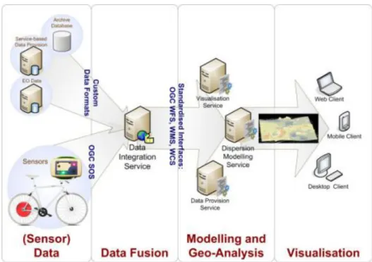
(Naphade et al. 2011) describe the smart cities and their future challenges. Public safety is one key factor besides education, healthcare, transportation and others. The operation center of Rio is described as an example of an integrated information space. As seen in Figure 3.1, they include dynamic information from weather sensors, video surveillance and others and combine them with GIS data to support the crisis and transportation management. For the future, more services should be connected to the system in order to have a closed-loop system.