6593
Ability Gpr Simulation To Detect Small Objects
With Geometric Shapes Different With Bow-Tie
Antenna
Fouad Lahlal, Ahmed Faize, Mohamed Atounti, Gamil Alsharahi
Abstract: Ground Penetrating Radar (GPR) technology is very important and it is used in many applications as (Civil engineering, geophysics, geology and other applications). The aim of this work is to simulate the efficiency and ability of GPR to detect buried objects and their suitability in many different situations and conditions. Also, among the objectives its ability to detection regular and random objects in a geometric shape. This program was used in this work GprMax, which depends on the principle of his work on the method of FDTD and works with Matlab. After this simulation, The GPR Civil engineering, geophysics, geology and other applications were high, and also antennas used for that.
Index Terms: Ground Penetrating Radar (GPR); simulation; ability; detection; objects.
————————————————————
1 INTRODUCTION
When you op In recent years, the nondestructive testing (NDT) of structures and soils using ground penetrating radars (GPRs) has become a mature technology. The particular interest in this technique is explained by several advantages when compared to other NDT techniques: the portability of the equipment because of its moderate weight, relative low cost of the survey, reasonable budget of the initial investment, and high versatility in terms of application for different purposes and scenarios. However, the success of GPR surveys is not straightforward due to the complexity of the physical phenomena involved [1-2]. The applicability of ground penetrating radar (GPR) as an aid to monitoring these processes has been investigated. GPR surveys have successfully resolved the shallow depth soil and geological structure [3-5]. The aim of this paper is to present initial results obtained in the first phase of a long-term effort to build a numerical model of the GPR operation on Mars and test dedicated signal processing algorithms on the simulated data. The simulation is based on the use of a Finite Difference Time Domain method, and we have pointed out some of its advantages that allow us to take into account complex features of the underground. The finite difference time domain (FDTD) method is used to analyze a practical ground penetrating radar (GPR) antenna system operating above lossy and dispersive grounds. The antenna is of the resistor-loaded bow-tie type and the analysis are made for two known soil types, namely Puerto Rico and San Antonio clay loams. [6-9]. Ground penetrating radar (GPR) is a high-resolution geophysical method, which is based on the propagation of high frequency electromagnetic waves.
Three decades since the commercialization of GPR, the vast majority of radar instruments are now applied for civil infrastructure applications. Ground‐penetrating radar is a surface‐geophysical method that depends on the emission, transmission, reflection, and reception of an electromagnetic pulse and can produce continuous high‐resolution profiles of the subsurface rapidly and efficiently. [10-11]. The development of imaging to estimate the electromagnetic properties of the medium include the dielectric permittivity ɛ (F/m) and the electrical conductivity σ (S/m), which are critical issues for a physical interpretation of the target structures. Moreover, GPR is based on the transmission and reception of 10 MHz–2.6 GHz electromagnetic waves into the ground [12-13]. The quantitative characterization of the shallow subsurface of the Earth is a critical issue for many environmental and societal challenges. Ground penetrating radar (GPR) is a geophysical method based on the propagation of electromagnetic waves for the prospection of the near subsurface. GPR covers a wide range of applications in geology, hydrology and civil engineering [14]. GprMax2D was also used with the development in the code and improved to achieve the goal of this work. We have obtained satisfactory and useful results through which we can determine the type of objects as conductors or dielectrics and also the geometric shape of these objects [15].
2
DESCRIPTION
METHOD
AND
SOFTWARE
2.1 FDTD based for GPR modelling and simulation
Maxwell’s electromagnetic equations that mathematically express the relations between the fundamental electromagnetic field quantities and their dependence on their sources can be used to describe all electromagnetic phenomena. The fundamental equations are acquisition methods have to be synchronized and all referred to the same coordinate system in order to integrate the geometric data collected by the different techniques [20]. There are four basic equations, called Maxwell equations, which form the axioms of electromagnetic.
2.2 System of GPRMax2D
The "GprMax 2D /3D" is a program designed in 1996 by Antonios Giannopolos, University of York Island. Aim to a wave simulator 2D and 3D of GPR as required by using the best adapted version of the desired work. It is based on the _________________________________
Fouad Lahlal, Ahmed Faize, Mohamed Atounti, Gamil Alsharahi Department of Physics, Faculty of Polydisciplinary, Mohammed
numerical method the FDTD [16-17].
Fig.1. The two-dimensional FDTD cell [17].
2.3 Principe of GPR
Electrode magnetic waves emitted into the ground and time measured for wave to be reflected and received (Fig.2). When wave hits areas of change in soil, it is hit back to receiver antenna changes in soil can include objects buried underneath the surface. Depth of Investigation varies from less than a meter to over 1000 meters, depending upon material properties. Detectability of a subsurface feature depends upon contrast in electrical and magnetic properties, and the geometric relationship with the antenna. Quantitative interpretation through modeling can derive from ground penetrating radar data such information as depth, orientation, size and shape of buried objects, density and water content of soils, and much more.
Fig.2. General working principle of GPR.
3 RESULTS
To simulate the GPR signals of objects by GprMax2d we need a certain number of parameters, such as the frequency of the antenna used, the geometry of the subsoil and targets, the dielectric permittivity, the magnetic permeability and the electrical conductivity. On a GPR image, each object below the surface appears as a hyperbola due to repeated reflections produced as the GPR unit passes over an object. In what follows, the results obtained for the different simulations carried out for different materiel as table 1.
TABLE 1
PROPERTIES PHYSICAL OF MATERIALS USED IN SIMULATION
Material Relative permittivity
Conductivity (S/m)
Velocity (m/ns)
wood 3 0.003 0.17
Iron 1.45 9.99*106 0.24
Empty Dry sand Water Sea water Plastic Rock Brick Clay wet
1 3 81 81 4 10 4 20
0 0.0001 0.0005 0.5- 4 0.002 0.1 0.001 0.1
0.3 0.17 0.03 0.03 0.15 0.09 0.15 0.067
3.1
BURIED
TARGETS
IN
MEDIUM
HOMOGENEOUS
The model of simulation by GprMax2d for detection of the buried objects in soil whose characteristics (εr =8 and σ = 0 .0001 S/m) and along 2m, depth 1m (Fig.3). Buried objects are empty and iron of various shapes (εr =1 and σ = 0 for empty and εr =1 and σ = 1010 S/m) at a depth of 0.5m (Fig.3a). Fig.3b present the radargram of detection the objects as show by hyperbolas and Fig.3e show the race of reflection signal from surface the objects.Notice in Fig.3a, the first object in the form of a triangle, the second body is rectangular, the third in the form of a semicircle and the fourth as a circle. Through these forms, the difference in the hyperbola (Fig.3c) of the reflected signals from the surface of each object.
6595 In this figure 4, we show a model to detect different circular
objects (water, plastic, water sea, iron and empty) buried in the middle of the soil (Fig.4a). Fig.4b present the radargram of detection the objects as show by hyperbolas and Fig.4c show the race of reflection signal from surface the objects.
Fig.4. Model of detection different circular objects at f=800 MHz (a) Modelling by GprMax2d (b) Radargram of model
detect medium contain targets (c) simulation GPR trace.
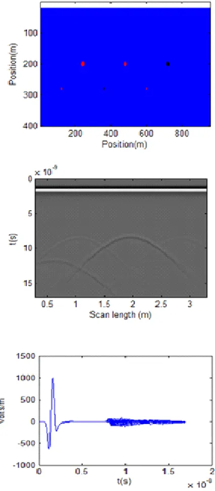
In Figure 5, very small circular (R=0.05) objects (concrete, iron, empty, rock) will be buried at depth 1m in a medium of soil as Fig .4a (Ox 3m and Oy 2m), and GPR performance will be tested in detecting it and determining its depth. Figure 4b represents a radargram detection buried objects and determine their depth through the appearance of hyperbola. Fig 4c trace GPR signal.
Fig.6. Model of soil contain two targets at f=400 MHz (a) Modelling byGprMax2d (b) Radargram of model detect two
targets (c) simulation GPR trace.
In Figure 6, GPR radar performance will be tested to detect and distinguish two crossed objects buried in medium of soil. Figure 5b represents a radargram detection buried objects and determine their depth through the appearance of hyperbola. Fig 5c trace GPR signal.
4
CONCLUSION
The simulation of the signals taken by the GPR radar and ability, by the software GprMax2d were successful. The simulations we carried out relate to dielectric and conductive
images, simulated or obtained, one notices the presence of the indicator hyperbolas which give information on the buried underground objects (depth, position according to the spatial directions x and y). We notice from the figures that hyperbola differs depending on the geometrical shape of the buried object and also on the physical properties of the object. Through the results obtained, the GPR ability to detect small objects buried in various conditions was very large.
REFERENCES
[1]. IDA, Nathan et MEYENDORF, Norbert. Handbook of Advanced Non-Destructive Evaluation. 2019.
[2]. DANIELS, D. J. Ground penetrating radar, ser. IEE Radar, Sonar, Navigation and Avionics Series. London: The Institution of Electrical Engineers, 2004, no 15.
[3]. M Gonzalez Huici, Accurate ground penetrating radar numerical modeling for automatic detection and recognition of antipersonnel landmines. Thèse de doctorat. Universitäts-und Landesbibliothek Bonn, 2013
[4]. CIARLETTI, Valérie, MARTINAT, Benoit, REINEIX, Alain, et al. Numerical simulation of the operation of the GPR experiment on NETLANDER. Journal of Geophysical Research: Planets, 2003, vol. 108, no E4.
[5]. TAFLOVE, Allen et HAGNESS, Susan C. Computational electromagnetics: the finite-difference time-domain method. Artech House, Norwood, 2005.
[6]. GOODMAN, Dean. Ground-penetrating radar simulation in engineering and archaeology. Geophysics, 1994, vol. 59, no 2, p. 224-232.
[7]. GUREL, Levent et OGUZ, Ugur. Simulations of ground-penetrating radars over lossy and heterogeneous grounds. IEEE Transactions on Geoscience and Remote Sensing, 2001, vol. 39, no 6, p. 1190-1197.
[8]. UDUWAWALA, Disala, NORGREN, Martin, FUKS, Peter, et al. A complete FDTD simulation of a real GPR antenna system operating above lossy and dispersive grounds. Progress In Electromagnetics Research, 2005, vol. 50, p. 209-229.
[9]. RAPPAPORT, Carey et EL-SHENAWEE, Magda. Modeling GPR signal degradation from random rough ground surface. In : IGARSS 2000. IEEE 2000 International Geoscience and Remote Sensing Symposium. Taking the Pulse of the Planet: The Role of Remote Sensing in Managing the Environment. Proceedings (Cat. No. 00CH37120). IEEE, 2000. p. 3108-3110.
[10]. DAVIS, J. Lꎬ et ANNAN, A. Peter. Ground‐penetrating radar for high‐resolution mapping of soil and rock stratigraphy 1. Geophysical prospecting, 1989, vol. 37, no 5, p. 531-551.
[11]. BERES JR, Milan et HAENI, F. P. Application of ground‐penetrating‐radar Methods in Hydrogeologie Studies. Groundwater, 1991, vol. 29, no 3, p. 375-386. [12]. ALSHARAHI, G., FAIZE, A., LOUZAZNI, M., et al.
Detection of cavities and fragile areas by numerical methods and GPR application. Journal of Applied Geophysics, 2019, vol. 164, p. 225-236.
6597 [14]. ALSHARAHI, Gamil, FAIZE, Ahmed, MAFTEI, Carmen, et
al. Analysis and Modeling of GPR Signals to Detect Cavities: Case Studies in Morocco. Journal of Electromagnetic Engineering and Science, 2019, vol. 19, no 3, p. 177-187.
[15]. LAVOUÉ, François, BROSSIER, Romain, GARAMBOIS, S., et al. 2D full waveform inversion of GPR surface data: permittivity and conductivity imaging. In : 2013 7th International Workshop on Advanced Ground Penetrating Radar. IEEE, 2013. p. 1-6.
[16]. ALSHARAHI, Gamil, FAIZE, Ahmed, DRIOUACH, Abdellah, et al. Determination of the Physical Properties and Geometric Shape of Objects Buried by Simulation Signals Radar GPR. In : 2019 8th International Conference on Modeling Simulation and Applied Optimization (ICMSAO). IEEE, 2019. p. 1-4.
[17]. GIANNOPOULOS, Antonios et DIAMANTI, Nectaria. Numerical modelling of ground‐penetrating radar response from rough subsurface interfaces. Near Surface Geophysics, 2008, vol. 6, no 6, p. 357-369.
[18]. WARREN, Craig, GIANNOPOULOS, Antonios, et GIANNAKIS, Iraklis. gprMax: Open source software to simulate electromagnetic wave propagation for Ground Penetrating Radar. Computer Physics Communications, 2016, vol. 209, p. 163-170.
[19]. ALSHARAHI, G., FAIZE, Ahmed, MOSTAPHA, A. Mint Mohamed, et al. 2D FDTD simulation to Study response of GPR Signals in homogeneous and inhomogeneous mediums. International Journal on Communications Antenna and Propagation (IRECAP), 2016, vol. 20. [20]. TAFLOVE, Allen. The Finite-Difference Time-Domain
Method. 1995.