Manorial or normal?
Assessment and comparison of the architectural and archaeological
characteristics of the main house at the Lost City of Trellech excavation
Cover image: digitized plan of the Lost City of Trellech house. The plan was created by myself, by compiling plan drawings of (parts of) the excavated walls, and footage taken by a drone during
excavations in 2014 (lostcityoftrellech.org).
Simon Kuyper
Rooseveltstraat 5E,2321 BK Leiden
Manorial or normal?
Assessment and comparison of the architectural and archaeological
characteristics of the main house at the Lost City of Trellech excavation
Simon Kuyper – 1119796
Thesis BA3
Mw Dr. R.M.R. van Oosten
Archaeology of Europe
Leiden University, Faculty of Archaeology
TABLE OF CONTENTS
1. INTRODUCTION TO THE SUBJECT OF THIS THESIS 1
1.1 TRELLECH AND ITS ARCHAEOLOGY 1
1.2 THE OBJECT OF RESEARCH 4
1.3 RESEARCH AIMS AND QUESTIONS 5
2. A SHORT HISTORY OF TRELLECH 7
2.1 INTRODUCTION 7
2.2 TRELLECH’S DEVELOPMENT 7
3. THE HOUSE 9
3.1 INTRODUCTION 9
EXCAVATION 9
DOCUMENTATION 10
3.2 SPATIAL AND MATERIAL ASPECTS 10
DIMENSIONS AND BUILDING MATERIALS 10
LAYOUT AND PHASES 11
3.3 DATING THE HOUSE’S PHASES 14
PHASE 1– MAIN OCCUPATIONAL PHASE 15
PHASE 2– THE ROUND FEATURE 20
ADDITIONAL COINAGE 20
CONCLUSION 22
4. COMPARISON TO KNOWN MANOR HOUSES 24
4.1 INTRODUCTION 24
4.2 COMPARISON OF THE HOUSES 25
WEST BROMWICH MANOR HOUSE 25
PENHALLAM MANOR 27
FIDDLEFORD MANOR 30
4.3 CONCLUSION 33
5. THE HOUSE’S MATERIAL CULTURE 38
5.1 INTRODUCTION 38
5.2 OVERVIEW OF FINDS 38
5.3 OVERALL COMPARISON OF FINDS 41
PENHALLAM MANOR 42
HAROLD’S HOUSE 43
NETHERNE WOOD 44
KENFIG CASTLE 45
PRELIMINARY CONCLUSION 46
5.4 OVERVIEW AND COMPARISON OF NOTABLE FINDS 47
ROOF FINIAL AND RIDGE TILES 47
COPPER ALLOY BUCKLE 48
COINAGE 49
LEATHER SHOE 49
FLOWER POT 50
5.5 CONCLUSION 50
6. CONCLUSION 51
6.1 SUB-QUESTIONS 51
BUILDING- AND OCCUPATION DATES 51
ASSESSMENT AND COMPARISON OF FORM ASPECTS 52 ASSESSMENT AND COMPARISON OF MATERIAL CULTURE 54
6.2 MAIN RESEARCH QUESTION 55
6.3 A MANOR HOUSE IN TRELLECH? 55
6.4 FUTURE RESEARCH 56
LOST CITY OF TRELLECH EXCAVATION 56
TRELLECH-WIDE EXCAVATION 57
ABSTRACT 59
CONSULTED WEBSITES 64
Preface
1
1.
Introduction to the subject of this thesis
1.1
Trellech and its archaeology
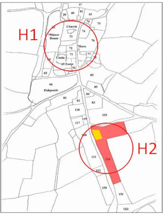
The subject of this thesis is the nature of one of the observed building plans at the Lost City of Trellech archaeological excavation in the Welsh south east county of Monmouthshire. The Lost City of Trellech excavation is located several hundred metres south of the current centre of Trellech, in a former agricultural field along Catbrook Road (figure 1.1). The plan of the excavation and the buildings is shown in figure 1.5. Trellech’s medieval history and function as a planted town1 owned by the noble de Clare family in the English conquering of Wales, has been the subject of research over the last decades. The research carried out at the Lost City of Trellech excavation is aimed at contributing to this, specifically to the existing debate on Trellech’s layout during that time. Previous archaeological research in Trellech has in general undertaken the task of determining the location of the medieval town centre. On this topic, two different hypotheses have been formulated, by Howell and Clarke (2005). The first hypothesis is that the centre of medieval Trellech was located at and around the current town centre (figure 1.2, abbreviated as H1). This hypothesis has been mainly defended by Howell (Howell & Clarke 2005) and other researchers at the University College of Wales Newport. The second hypothesis was first formulated by Julia Wilson (Wilson 1998), and later defended by Stephen Clarke (Howell & Clarke 2005) and, Stuart Wilson (2005) – who is not related to Julia Wilson. This hypothesis says that the centre of medieval Trellech was located south of its current centre (figure 1.2, abbreviated as H2). Hypothesis 1 is deemed likely because of the location of the current town centre; for instance, the remains of the castle and the church are located close to it. This interpretation entails that the town centre was close to such structures. In contrast, proponents of hypothesis 2 say that the elongated strips of land, known as burgage plots, that contained the houses of which the medeival town
1 A planted town was “an urban settlement that was deliberately constructed to a preconceived plan” (Darvill 2008, entry: Planted town). Some planted towns were built by enlarging already existing towns.
2
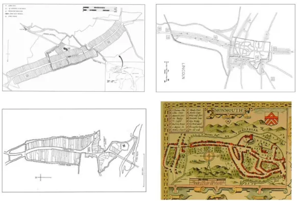
largely consisted, are only found surrounding Catbrook Road, rather than in the current town centre. It has been argued that this confirms the notion that Trellech was built according to a pattern customary for planted towns (Bradney 1913, 130). The comparison in figure 1.3 of the layout of four other planted towns to Trellech’s layout shows this customary pattern of a town centre with an elongated extension of burgage plots. Trellech’s alleged growth based on this comparison (figure 1.4) indicates that in this scenario, large parts of Trellech during its peak would have been located south of the current centre, along current Catbrook Road. The red area in figure 1.4 indicates the location of Trellech’s 12th century phase, from before Trellech’s main period of growth; the other two phases show the extent of Trellech’s growth in the 13th century, leading up to when Trellech was at its largest under de Clare ownership.
3
Figure 1.4 – Three proposed phases in Trellech’s development: red indicates the first phase, dark blue the second and green the third (Jenkins 2012, 91).
4
1.2
The object of research
The interpretation of the remains of the main building at the Lost City of Trellech excavation is an important part of the aforementioned discussion. The remains of the building are located in a former agricultural field, along a modern road. The building is of a rough square size and can be divided into nine different areas. On the website of the excavation (lostcityoftrellech.org) Wilson claims that the uncovered building plans are the remains of a manor house. This denomination owes its origin to the term ‘manor’, which was the smallest unit of land and ownership in the medieval feudal system (Anonymous 2009). This system was based on land ownership by lords who had 'tenants' living on their land, working there in exchange for services and protection, provided by the lord of the manor. The manor encompassed areas such as a small town, a church, agricultural land, common pastures and woodlands (Shepherd 1923, 104). The manor also contained the building the lord of the manor resided in, the manor house. A manor house most crucially contained a great hall with a high ceiling (Morgan 2014, 110)2, the most important centre of activity within the house. Often, this hall lined an open courtyard, which was surrounded by other buildings, such as a bedroom (Morgan 2014, 110), a kitchen (and the adjoining pantry and buttery), stables, servants’ quarters, a bakery, a dovecote, a chapel and sometimes fortification in the form of a tower. These buildings were often located within the inner walls surrounding the courtyard and manor house. Unfortunately however, the plausibility of characterising the house at the Lost City of Trellech excavation a manor house, has not yet been
2 The text cited in Morgan 2014 was issued by the Historic Manuscript Commission (Reports 9, I).
5
researched. Therefore, the aim of this thesis is to provide arguments on the (in)validity of the characterisation as manor house, and to add to the broader discussion of medieval Trellech.
It has to be understood that when discussing the subject of manorialism, we must accept a certain distinction. For in describing what a manor and manor house are, we recognize aspects of form and aspects of function. Form aspects describe what a manor and manor house looked like, while function aspects describe what a manor house was in its relation to the surrounding land and its inhabitants. A manor house was the centre of the lord’s juridical and administrative duties towards the manor. Unfortunately, it is not possible to prove through archaeological research that it was the case that the owner of the house was also the owner and lord of a manor. This is important, since it is also possible that the owner of this house was a non-manorial aristocrat, meaning that the house is not technically a manor house. To keep with this form-function distinction, the two aspects will be discussed separately.
1.3
Research aims and questions
Now that we have an impression of the concept of manorialism and aspects associated therewith, we know what to look for in the gathered data. The main research question we will answer using these data is the following:
Given the descriptions of manor houses by Shepherd (1923), Yarwood (1983) and Morgan (2014), and of their material culture by Beresford (1974), Ketteringham (1976), Thompson (2007) and Brennan (2007), how plausible is the interpretation of the main building observed at the Lost City of Trellech excavation as manor house?
To aid in the answering of this question, the following sub questions are used:
What building- and occupational phases are present in the house? To what periods do these
phases date?
o Which different phases of building and occupation are recognized in the house?
o What relevant, datable finds are there and what do they tell about the dates of these phases?
o What more information is there regarding the house’s age and what does it tell?
6
o What areas of the house are observed that are associated with the layout of a manor house (i.e. a great hall, courtyard, kitchen, storage, living quarters, defensive feature such as a tower)?
o How does the layout of observed areas compare to that of manor houses of the same period?
o How does the house’s size compare to that of manor houses of roughly the same period?
o How do the house’s used building materials compare to that of manor houses of the same period?
Research by Beresford (1974), Ketteringham (1976), Thompson (2007) and Brennan (2007) gives an idea of the material culture encountered at manor house excavations. Given these data, what does the material culture of the Lost City of Trellech excavation tell us about the nature of the house?
o How does the house’s general assemblage of finds compare to that of manor houses of roughly the same period?
o How do the notable finds encountered in Trellech compare to those of manor houses from roughly the same period?
7
2.
A short history of Trellech
2.1
Introduction
In this chapter, the historical development of Trellech as a relatively large and quickly expanding medieval town are laid-out. This provides an idea of the context in which the object of research, the house at the Lost City of Trellech excavation, existed.
2.2
Trellech’s development
Historical evidence indicates that the town of Trellech was the centre of iron working from the 11th to the 16th century (Penrose 1997, 195). As a result of this industry, the town became relatively large and densely populated mainly during the years between 1245 and 1288. However, years of decline after its heyday caused the loss of the city of Trellech as it was in its medieval state. While the height of Trellech’s wealth and prosperity started when the town was planted by the de Clare family in 1245 (Hindle 2002, 8), records of an inquest show that the town consisted of 180 burgages even in 1150 (Delaney & Soulby 1975). At the recorded height of its occupancy, in 1288, Trellech consisted of as many as 378 burgages. Given this number, and the estimated mean amount of members per household during this time of five, a population of at least 1890 people is estimated (Soulsby 1983, 19 – 24; Blekemolen 2017, 38). Comparing this to several notable towns and cities at the same point in time, we see Trellech was not much smaller than the largest town in Wales, Cardiff (Campbell 2008, 55 – 56). Additionally, the middling one-third of towns in Wales at the end of the 13th century contained between 50 and 150 burgages (Souslby 1983, 19 – 24). Comparing this to Trellech’s largest number of burgages of 378, we see that Trellech was well above average in size. It was therefore once close to being the largest city in Wales.
As stated, the intentions the de Clares had in planting the town of Trellech were mainly industrial in nature: iron was produced and worked to supply the army the family controlled. The de Clare family and their army played a role in the late 13th century Edwardian Conquest of Wales (Weeks 2008, 155), which resulted in the annexation of Wales by Edward I (Davies 2000). To produce large amounts of
8
material, iron workers were invited from other iron working settlements to work in Trellech. While its location was not particularly advantageous for trade purposes, it was suited relatively well for iron production, because of its proximity to resources needed for iron working, wood and iron ore (Clarke et al. 1982, 49). Additionally, because it was located near the border with England (figure 2.1), it was relatively safe from Welsh raids (Hopkins 2008, 125). These favourable traits made Trellech a relatively well-suited location for supplying an army requiring access to Wales.
Because of its size and wealth, Trellech became an administrative division, defined as a self-governing town, allowing it to host markets, fairs and local trials (Courtney 1983, 167). Records show that beside the iron industry, Trellech was also involved in trading locally sourced lumber. Even during and after the decline of its wealth, Trellech remained active in the trade of these materials (Courtney 1983, 167).
The decline of Trellech came about almost as rapidly as its rise. An inquisition in 1307 recorded the presence of as little as 410 people in Trellech at the time, of which a mere 228 were listed as townspeople (Courtney 1983, 167). They lived in the 271 burgages that were left at this time. The major cause of this initial decline was the destruction of 102 burgages, as a result of a fire that broke out during a Welsh attack on the settlement in 1296 (Howell 1995, 71). During this time, the local motte-and-bailey castle3 was also abandoned (Soulsby 1983, 256). After the initial hit Trellech took, the decline continued in the form of the partitioning of the de Clare lordships after the death of the last male heir of the de Clare family in 1314 (Courtney 1994, 128). In addition to this political cause, the effects of change in climate, an outbreak of the plague, and growing competition from towns such as Monmouth also had a negative effect on the livelihood of the settlement during the 14th century (Hopkins 2008, 118). These processes are commonly considered the causes for Trellech’s decline, however the town never ceased to exist. Records show that between the years of 1329 and 1330, income was still being generated through the sale of lumber (Courtney 1983, 167). Archaeological evidence for the inhabitancy of the settlement during later centuries will be discussed in chapters 3 and 4 of this thesis.
9
3.
The house
3.1
Introduction
In this chapter, the spatial and material aspects of the construction of the house at the Lost City of Trellech excavation will be discussed, as well as its date on the basis of material finds. Firstly, the house’s size, layout and used building materials as found during excavations are shown. Then, the current interpretation of the house’s areas will be explained. Finally, the house’s phasing and the phases’ dates are discussed by looking at datable ceramics and coinage. In this process, a distinction is made between dating the period during which the house was built, and the period during which the house was firstly inhabited. As it has been stated in the preface, the same fieldwork data are used for Blekemolen’s (2017) and this research, causing a significant overlap in the description and interpretation of the Lost City of Trellech house in this chapter of the current research, and paragraph 4.4 of Blekemolen (2017, 73 – 78).
Before going into the general purpose of this chapter, first some remarks will be made regarding the methods of excavation and documentation on the site. These remarks are especially important for readers not familiar with British archaeology, to better understand the terms and descriptions used in this thesis.
Excavation
The Lost City of Trellech excavation started in 2005, when Stuart Wilson bought the plot of land in which it is located. Since then, excavation has been carried out every year, mainly during the summer months. Unlike the uncovered building plans and the finds, the documentation of the excavation has unfortunately been of poor quality in the early years. For example, of several rare and important artefacts, it is today unclear from where exactly in the excavation they came and how they relate to the building’s phases. Since 2012, documentation of the excavation has significantly improved by virtue of the efforts of Sander Aerts and Vincent Blekemolen, in co-operation with Stuart Wilson. This has allowed for more accurate and thorough interpretation of the project’s findings.
10
Documentation
On the excavation in Trellech, as well as in the rest of British archaeology, excavated areas are described and documented in terms of contexts, features and sections. On British excavations, a context is the smallest identifiable stratigraphic unit recognized in an excavation (Darvill 2008, entry: Context); in practice this means a context is a collection of material in an excavation belonging together for reasons of similarities in soil type, soil colour, soil consistency, or archaeological content. During excavation, a context can turn out to be a distinct feature. Such a feature is defined as a patterned arrangement of archaeological contexts, forming an interpretative category (Darvill 2008, entry: Feature). A feature can for instance be a wall, a floor, a building, a ditch, et cetera. In order to understand stratigraphic relations between contexts and features, sections are used for interpretation. A section is a vertical face cutting through different contexts and features, to allow such interpretation of stratigraphy (Darvill 2008, entry: Section). These elements are all numbered, listed and described in detail on separate sheets and then photographed and sometimes drawn. Additionally, dumpy levels are taken of points of interest (important finds, features, the depths of different layers, et cetera) and assigned numbers on excavation plans. The excavation plans are updated daily, to keep in view the excavation as a whole and the locations of its important aspects.
3.2
Spatial and material aspects
Dimensions and building materials
Unfortunately, no precise (digital) data exist on the dimensions of the house at the Lost City of Trellech excavation, so the measurements that will be mentioned are based on figure 1.5. By extension this means that these measurements are arrived at using extrapolation from drawings made at the excavation and footage of the excavation captured by a drone (lostcityoftrellech.org).
11
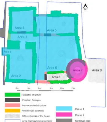
All measurements have been compiled into one overview: figure 3.1. In this figure, we see that the house is roughly a square, as it is equal in length and width, which are both about 21.5 metres. The surface area of the inside portion of the house is roughly 132m²; this excludes area 6, the outside courtyard. This only accounts for the ground floor surface area; extra stories would have also meant extra surface area. Area 7, the round feature, is roughly 6 metres in diameter and is 28 m² in size; area 8 has an in inner surface area of approximately 7.9 m². Finally, area 9 is not technically part of the house, but in recent years, excavation has showed the possible presence of a ditch.
All walls of the house are entirely made of stone (figure 3.2). The outside walls are on average from 1 metre wide at the base to 0.5 metre higher up; this applies to the walls around the courtyard as well. Thinner walls that lie entirely inside the house are around 0.5 to 0.75 metres thick. No wooden support beams belonging to the structural frame of the house have been found during excavation. This likely indicates their degradation over time in the acidic soil. All wood that was found at the excavation came from the well and was preserved in the waterlogged conditions. However, none of it is large enough to be interpreted as structural material. Notwithstanding, it is safe to assume that a wooden framework was used in at least the roof’s construction. Pegged stone roof tiles (figure 3.3) are abundantly found all over the excavation, indicating the roof’s construction, which was would have needed a support structure able to carry a substantial amount of weight.
Layout and phases
The house consists of nine different areas, as shown in figure 1.5. Seven of these areas are inside rooms and the other two are outside areas. During excavation and on lostcityoftrellech.org, these areas have been interpreted as shown in table 3.1. To add to (the strength of) this interpretation, the areas, their dimensions, known features and other information have been compiled into this table.
Figure 3.3 – Schematic view of the relation of roof slates and its pegs to the roof’s wooden construction (Harrison 2009, 1)
12
Table 3.1 – Summary and interpretation of the areas of the house at the Lost City of Trellech excavation, based on the areas and measurements shown in figure 1.5 and figure 3.1 respectively.
Dimensions Important features and aspects of the house’s areas (figure 1.5) and the areas’ interpretation
Area 1 1 x 1.5 = 1.5m² Its location immediately adjacent to the road and access it provides to the house’s largest room (area 2) indicates this area was a porch.
Area 2 6 x 7.5 = 45m² 2.1: central round stone, interpreted as a central hearth, common to larger houses (wealddown.co.uk, entry: Wealden house).
2.2: this part of area 2 is a roughly square space with thin walls around it, making it a likely location for a winding staircase; its location in the great hall and close to the porch area makes it an accessible location for a staircase. In addition to these features, the general size of the room and the location alongside and accessibility from the road are important aspects indicating this was the house’s central great hall.
Area 3 1.5 x 6.45 = 9.68m² This elongated corridor separated area 2 from 4 and 5; it additionally provides possible entrance from the road to the courtyard (area 6). This area is interpreted as a cross-passage. Such passages separated the hall from service areas.
Area 4 5.25 x 4.95 = 25.99m² Its location adjacent to area 5 indicates this area was likely to have been a service area, such as a pantry or other type of storage room.
Area 5 9.75 x 4.35 = 42.41m² 5.1: fireplace with chimney.
5.2: lintel belonging to the fireplace.
5.4: a single round stone, probable base of furnace.
These features, in combination with the area’s location in relation to areas 2 and 3, indicates this area was likely the house’s kitchen. 13th century manor house kitchens often contained two places to cook (Morgan 2014, 110), in this case a fireplace and a type of furnace.
In addition to these features, in front of the fireplace a floor surface was found, that has been identified with the main occupation phase of the house, which will therefore be important for the dating of this phase.
Area 6 9.75 x 12 = 117m² 6.1: stone slabs of roughly 1.5 by 1 metre, attributed a laundry and drainage function.
13
Mainly this preserved water well tells us this area was the courtyard, and this is confirmed by the nature of feature 6.2, for the associated laundering activities would be carried out outside.
In addition to the two features, a cobbled floor surface is visible here, again associated with the house’s main phase, and therefore likewise important in dating this phase.
Area 7 6 metres in diameter Due to the immense thickness of the walls of this area – around 2 metres – , as well as its integration into the outer courtyard walls, its prevailing interpretation is as a tower. However, no conclusive evidence has been found for this yet. Another hypothesis is that it was a dovecote, but no evidence was found for this at all.
Area 8 5.25 x 1.5 = 7.88m² No archaeological evidence has been found here yet, but it has been hypothesized this was a chapel (lostcityoftrellech.org).
Area 9 Not fully excavated In this area, excavation revealed stratigraphy of different layers to as deep as two metres. It has not yet been fully excavated, so its total depth is still unknown. The stratigraphic layers are interpreted as the fills of a ditch. It remains unclear as of yet whether it would be a drainage or defensive ditch.
These areas of the house are divisible into two separate phases (figure 3.4): areas 1 to 6 are all of the same period of construction (phase 1), indicated by the way their walls’ constructions interlock, whereas the round feature was built at a later date (phase 2). Its walls do not interlock with the other areas’; in fact, the point where the east wall of area 6 meets the north side of the round feature (figure 3.4), the courtyard wall’s construction suggests it was partly demolished and later built up against the round feature. This suggests that this wall had to make way to put area 7 in place after the initial construction of phase 1. To be clear, it could very well be that there was an overlap in phases 1 and 2, meaning that the inhabitants of main occupational phase
14
1 were still present during the start of phase 2; i.e., the owners during phase 1 added the round feature and continued living there during phase 2. Furthermore, as we see in figure 3.4, the supposed chapel (area 8) has not been assigned a phase yet. The connection of its walls to those of area 2 or area 7 has been excavated, but not yet been fully researched and interpreted in terms of the sequence of construction. It is therefore still unclear what its relation to these areas is and thus to what phase area 8 belongs. Notwithstanding, the division of phases 1 and 2 indicates that the house was initially built as a house with a great hall, kitchen and walled courtyard, and that the round feature was later added. Areas belonging to phase 1 (whether this includes area 8 or not) are interpreted as having been inhabited during the main occupational period of the house. The round feature was an addition to these areas and therefore belongs to a separate building phase: phase 2.
3.3
Dating the house’s phases
15
Phase 1 – main occupational phase
3.3.1.1 Area 5
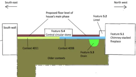
During the campaign of 2015, areas 5 and 6 (figure 1.5) were the main focus of excavation. In area 5 the contexts of interest are contexts 4008 and 4011 (figure 3.6). Besides these contexts, area 5 contains six distinct features, all shown in figure 3.5. There is the chimney fireplace (feature 5.1), the lintel4 that belonged to the fireplace (feature 5.2) and a drain running along the fireplace (feature 5.3). Additionally, there is the big round stone in the west area of the space (feature 5.4) and the drain that goes underneath it (feature 5.5). Lastly, there is an horizontal layer of large and heavy stones located underneath the foundations of the main phase’s walls, which are the possible remains of an earlier occupational period (feature 5.6).
Contexts 4008 and 4011, as well as features 5.1 to 5.4 in area 5 are important for the interpretation of several finds that will be used for dating phase 1. Their juxtaposition and stratigraphic relation are displayed in figure 3.6; the location of this sectional view is indicated in figure 3.5. The finds that are of interest to us, come from contexts 4008 and 4011, which lie directly underneath the surface that is interpreted as the main floor level of area 5,
4 A lintel is the horizontal block that spans the space between two vertical supports, for instance the two sides of a fireplace (Darvill 2008, entry: Lintel).
Figure 3.5 – Plan of Area 5 (figure 1.5) of the house at the Lost City of Trellech excavation. The numbers designate the area (first digit) and feature number (second digit) respectively. Additionally, the location of the section shown in figure 3.6 is displayed. This plan is part of that shown in figure 1.5.
16
therefore belonging to phase 1. This surface is interpreted as such, for its relation to features 5.1, 5.2 and 5.4. Feature 5.1 was built along with everything else from phase 1, and the lintel (feature 5.2) was initially part of the chimney (feature 5.1). Therefore, feature 5.2 is directly associated with the date of phase 1; since it is located directly on top of the surface in question, this surface is understood to be the main floor level of area 5. The same goes for feature 5.4, which was the bottom of a cooking furnace. This feature was also located directly on the surface during the main occupational phase of area 5, namely phase 1. In short these features indicate that dating the floor surface in figure 3.6 gives us a date for area 5’s occupation and by extension for phase 1. Contexts 4008 and 4011 constitute the layer directly underneath this floor surface, so finds from these contexts are interpreted as belonging to this surface.
The datable pottery finds from contexts 4008 and 4011 are displayed in figure 3.7 to figure 3.9. Below, in table 3.2, these pieces of pottery are categorized and presented. Types are based on Clarke’s (2011) typology of pottery from the Monmouthshire area, to which these sherds belong and were therefore compared.
Table 3.2 – Overview of the pieces of pottery found in area 5 of the house used for dating the main period of the house. Typology codes according to Clarke’s “Medieval and Later Pottery Fabric Series” (Clarke 2011, Appendix B)
Small Find number
Figure number
Area number in the house
Context number
Type of pottery (Clarke 2011, Appendix B) and description
Date SF1505, one potsherd; no relation to other known sherds
Figure 3.7 Area 5 (figure 1.5) 4008 Type A5; oxidised, externally glazed jug
handle with small inclusions. (correspondence with Sander Aerts)
13th – 14th
century SF1507, one potsherd; no relation to other known sherds
Figure 3.8 Area 5 (figure 1.5) 4008 Type A5; oxidised, externally glazed jug
handle with small inclusions. (correspondence with Sander Aerts)
13th – 14th
century SF1511, one potsherd; no relation to other known sherds
Figure 3.9 Area 5 (figure 1.5) 4011 Type A 5; slightly tempered with quartz
sand, internally and externally glazed potsherd. (correspondence with Sander Aerts)
From 13th
17
The data from table 3.2 signify that the potsherds associated with phase 1 in area 5 are either from the 13th to 14th century, or from the 13th century onwards. These dates will be combined with dated pottery from area 6.
Figure 3.7 – Ceramics small find SF1505, area 5 (figure 1.5), context 4008 (see table 3.2)
Figure 3.8 – Ceramics small find SF1507, area 5 (figure 1.5), context 4008 (see table 3.2)
18
3.3.1.2 Area 6
As with area 5, so too are the dated finds from area 6 related to a floor surface directly associated with phase 1. Features 6.1 and 6.2 (figure 1.5) both indicate the location of this surface. Since these features are thought to have been used during phase 1, contexts associated with this surface are of the same value for dating phase 1 as were contexts 4008 and 4011. In the case of area 6, these are contexts 5003 and 5005. Both contexts were excavated near feature 6.1, the stone slabs in the corner of area 6 (figure 1.5) and are related to them. These slabs are on the same level as the cobbled surface found around the well, thereby also belonging to phase 1. The dated sherds therefore have the same instrumental value as those from area 5. Sherds from area 6 are described in table 3.3. As with table 3.2, types are based on Clarke’s (2011) typology of pottery from the Monmouthshire area, to which these sherds were compared. Sherd SF1509 shows that the earliest dating of phase 1 in theory is the 12th century. However, the dating of the house to the 12th century is unlikely in light of the dates given to the other sherds. These all give the earliest dating of the 13th century, as does sherd SF1510 from area 6.
Table 3.3 – Overview of the pieces of pottery found in area 6 of the house, that were used for dating the main period of the house. Typology codes according to Clarke (Clarke 2011, Appendix B)
Small Find number
Figure number
Number of the area in the house
Context number
Type of pottery (Clarke 2011, Appendix B) and description
Date SF1509, one potsherd; no relation to other known sherds
Figure 3.10 Area 6 (figure 1.5) 5003 Type C1 (Bristol Ham Green) or C2
(Bristol Redcliffe); externally glazed potsherd. (personal
correspondence with Sander Aerts)
12th (C1) - 13th
century (C2) SF1510, one potsherd; no relation to other known sherds
Figure 3.11 Area 6 (figure 1.5) 5005 Type A5; internally glazed potsherd.
(personal correspondence with Sander Aerts)
From 13th
century onwards
3.3.1.3 The well
19
1300 – 1310 (Blekemolen 2016, 10). This means two things, namely that it is likely that inhabitation of phase 1 started around 1250, and that phase 1 was inhabited until at least 1300.
Figure 3.12 – Remains of a ceramic jug, found on the bottom layer of the well during 2006 excavations (lostcityoftrellech.org)
Figure 3.10 – Ceramics small find SF 1509, area 6 (figure 1.5) context 5003 (table 3.3).
20
Phase 2 – the round feature
Research in area 7 has so far yielded little evidence for the area’s date. We know however that the area was built during a later period than areas 1 to 6 were, as indicated by the relation of area 6’s east wall to the construction of area 7 (see paragraph 3.2.2). However, one of the three silver coins found at the excavation in recent years provides us with valuable information, presented in table 3.4.
Table 3.4 – One of the coins found at the Lost City of Trellech excavation, used to date phase 2, area 7 of the house (figure 3.4).
Small Find number
Figure number Number of the area in the house
Context number
Type of coin Date
SF1442, one coin, no fracturing
Figure 3.16 Associated with
rubble from the collapse of area 7.
3031 (rubble layer from area 7)
Edward I of England, silver penny (personal
correspondence with Edward Besly)
1272 – 1307
This coin was not found within the walls of area 7 itself, but close to it, namely within context 3031 (figure 3.13). This context was one of the layers of rubble associated with the collapse of the round feature. The coin indicates that the round feature was likely added to the areas of phase 1 somewhere between the years of 1272 and 1307. Additionally, the coin gives the indication that phase 1 was likely built before 1272.
Additional coinage
Two other silver coins were found at the excavation, whose contexts are unknown. In table 3.5, the available information regarding these coins is presented. Based on this, these coins show that the house was still (or again) inhabited during both the 14th and 15th century.
Table 3.5 – Overview of the coins found and used for the general dating of the house
Small Find number
Figure number
Number of the area in the house
Context number
Type of coin Date
SF1401 Figure 3.14 Unknown Unknown Edward I of England, penny
(personal correspondence with Edward Besly)
1302 – 1303
SF1402 Figure 3.15 Unknown Unknown Ireland, Edward IV, silver half
groat (personal correspondence with Edward Besly)
1461 – 1483
21
Figure 3.14 – Medieval coin found on-site; area and context number unknown (table 3.5)
Figure 3.15 – Medieval coin found on-site; area and context number unknown (table 3.5)
22
Conclusion
3.3.4.1 Phase 1 and 2 construction dates
Table 3.6 – Combined dates of datable finds from areas 5 to 7
1100 – 1150 1150 – 1200 1200 – 1250 1250 – 1300 1300 – 1350 1350 – 1400
Coin SF1442 Potsherd SF 1505, area 5 Potsherd SF 1507, area 5 Potsherd SF 1511, area 5 Potsherd SF 1509, area 6 Potsherd SF 1510, area 6 Jug from the well, area 6 Roof finial from the well, area 6
The data in table 3.6 indicate to us that phase 1 of the house at the Lost City of Trellech was built during the 13th century. Where most potsherds indicate that phase 1 could have started in the 14th century, potsherd SF1509 shows it was built before that. Conversely, the other potsherds indicate it could not have been built as early as the 12th century. In addition, we know that phase 1 was likely built before phase 2’s earliest date, 1272, based on coin SF1442 (table 3.4). And finally, the finds from the bottom of the well show that the first depositions in the well dated earliest to 1250. What ultimately remains as the most likely building date of phase 1 is therefore 1250 – 1272. We can likewise deduce from this that phase 2 was likely built after 1272.
3.3.4.2 Occupancy dates
23
table 3.5 indicates that the house was inhabited as late as 1303 – 1304. The same goes for coin SF1402, which shows occupation during the 15th century. Whether these dates belong to either phase 1 or 2 is unclear.
24
4.
Comparison to known manor houses
4.1
Introduction
In the previous chapter, an overview of the house at the Lost City of Trellech excavation and its date has been given that shall form the basis of the current chapter. In this chapter, this overview will be used to make a comparison of the house in Trellech to four known manor houses. Their locations are displayed in figure 4.1. Form aspects of the house in Trellech will be compared to those present at these manor houses, to see if we can rightfully speak of a manor house in the case of the Lost City of Trellech excavation. The form aspects that will
be compared are the following: general size and number of areas on the ground floor, and the nature of these areas. Specific attention will be paid to the presence of areas that were typically present in manor houses according to Yarwood (1963, 84), which were the great hall, courtyard, kitchen, pantry, buttery or other storage, service quarters, chapel and private quarters. It is important to note the distinction between private and common areas in manor houses. The lord’s private quarters were often located on the house’s first floor, called a solar
(Anonymous 2008), and were only accessible to him and his family, while other areas were common areas, accessible for guests, servants and the manor’s inhabitants, during the fulfilment of the lord’s juridical duties. Finally, the dimensions of both the great halls and courtyards will be compared, as well as the used building materials. Other striking similarities and differences will be highlighted and discussed.
25
4.2
Comparison of the houses
West Bromwich manor house
The first manor house used for comparison is located in West Bromwich, in West Midlands county, England (figure 4.1, number 1). The house depicted in figure 4.2 was built during the late 13th century (Baggs et al. 1976, 14). In the 16th century, buildings were added to it, but these have been left out for our current purpose. Since the 13th century, the entire house has been enclosed by a wide defensive moat, providing defence and protection (Baggs et al. 1976, 14). The house is located within the town of West Bromwich, a small town located close to the capital of the West Midlands, Birmingham. The 13th century manor house at West Bromwich has a total indoor ground floor surface area of 170 m². It is thereby about 40 m² larger than the Trellech house. The great halls of both houses are roughly the same size, while Trellech’s courtyard is almost twice the size of that in West Bromwich (table 4.1). The roof of West Bromwich manor house is of sturdy slate construction, while the walls of West Bromwich are made of wood (Baggs et al. 1976, 16). While Trellech’s roofs were also slated, its walls are made of stone, rather than of wood. The first area of the West Bromwich manor house built in the 13th was the great hall, the largest room of this house, measuring ~42 m² (Baggs et al. 1976, 14). In the 15th to 16th century, a chapel, gatehouse and kitchen were added to the plan in figure 4.2 (Baggs et al. 1976, 14). The great hall is the central feature of this house. In the great hall of West Bromwich manor house, no fireplace built into the wall is visible in the house plan (figure 4.2). However, such a hall would have needed a heat source. Therefore it is assumed that a round hearth central to the hall was in place during its occupation, as is the case in Trellech. On the south end of the great central hall, the 13th century hall was separated from the service wing by a cross-passage similar to that observed in Trellech (figure 1.5, area 3). On the other end of the hall, the parlour wing was located, providing space for the lord and his family. Additionally, on the west end of this part of the house, we see a staircase, in a semi-square walled space, similar to feature 2.2 in Trellech’s area 2 (figure 1.5). Likewise, it is adjacent to the great hall, providing access to a story above it,
Figure 4.2 – Floor plan of the West Bromwich manor house (figure 4.1). Image was edited after Baggs et al. (1976, 15), to show 13th century buildings
26
possibly containing more private space for the lord and his family. Should feature 2.2 at Trellech prove to be a staircase, such an upstairs room is also likely to have been present in Trellech. It is unclear how the courtyard was screened before the gatehouse, but it is plausible that a less substantial curtain wall was in place at the east end of the courtyard. As with the house at the Lost City of Trellech excavation, West Bromwich’s courtyard is central to the house’s construction and surrounded by its buildings. Even though the specific rooms on both ends of the hall in West Bromwich differ in nature from those in Trellech, the general layout of the house and its courtyard aree quite similar.
Table 4.1 – Comparison of the house at the Lost City of Trellech excavation to West Bromwich manor house, in terms of their age, dimensions, building materials and types of rooms present.
House Lost City of Trellech West Bromwich manor house
Date ~ 1250 – 1300 13th – 16th century
Important dimensions Total inside ground floor surface:
~ 132 m²
Great hall:
~ 45 m²
Courtyard:
~ 80 m²
Total inside surface:
~ 170 m²
Great hall:
~ 42 m²
Courtyard:
~ 45 m²
Building materials Stone and mortar walls, slate roof tiles Timber walls, slate roof tiles
Number of rooms visible on ground floor plan (including courtyard)
9 9
Types of areas visible on ground floor plan Porch Great hall Cross-passage Kitchen Storage Courtyard 3 unknown Possible chapel Possible tower Possible ditch Great hall Cross-passage 3 service rooms 3 parlour rooms Courtyard
Consulted sources lostcityoftrellech.org
Data from Chapter 3 of this thesis
27
Penhallam manor
The Penhallam manor house is located near the small town of Week St. mary, in Cornwall county, England (figure 4.1, number 2). The house is located almost one kilometre from the nearest town, Week St. Mary and is surrounded by forest and agricultural land. Over the years between 1968 and 1973, the remains of a house were discovered during archaeological survey and excavation. The research revealed a clear and well-preserved layout of the 13th century manor house. Small parts of it are from the 12th century, while the largest portion is early to late 13th century. The house was rather large in comparison with the Lost City of Trellech house, namely almost five times as large in total. Its great hall was twice that of Trellech’s size, and courtyard more than triple the size (table 4.2). In terms of building materials, the two houses are quite similar, for both had stone walls and a tiled roof (Beresford 1974, 102). In figure 4.3 the well-preserved remains of the house’s layout are portrayed, showing the components of the manor house. These components are the great hall, a kitchen, a buttery, a bakery, a chapel, stables and a solar. Additionally, the house contained a so-called camera, which was another type of high room,
28
29
Table 4.2 – Comparison of the house at the Lost City of Trellech excavation to Penhallam manor house, in terms of their age, dimensions, building materials and types of rooms present.
House Lost City of Trellech Penhallam manor
Date ~ 1250 – 1300 13th century
Important dimensions Total inside ground floor surface:
~ 132 m²
Great hall:
~ 45 m²
Courtyard:
~ 80 m²
Total inside surface:
~ 620 m²
Great hall:
~ 90 m²
Courtyard:
~ 255 m²
Chapel:
~ 25 m²
Building materials Stone and mortar walls, slate roof tiles Stone and mortar walls, ceramic roof
tiles Number of rooms visible on ground
floor plan (including courtyard)
9 13
Types of areas visible on ground floor plan Porch Great hall Cross-passage Kitchen Storage Courtyard 3 unknown Possible chapel Possible tower Possible ditch Great hall Cross-passage Buttery Bake house Kitchen Pantry Larder Courtyard Chapel Camera Wardrobe 2 Garderobes
Consulted sources lostcityoftrellech.org
Data from Chapter 3 of this thesis
30
Fiddleford manor
Located in Fiddleford, Dorset county, England (figure 4.1, number 3), this manor house is of a slightly later date than the house at the Lost City of Trellech excavation (mid-14th century). The house is located alongside a country road and next to a river, all very close to the small town of Fiddleford. In terms of its general size, the inner surface area of Fiddleford manor house is about 50 m² smaller than the house in Trellech. Its construction and materials used for the walls and roof are similar to those used in Trellech. In figure 4.4 Fiddleford’s layout is portrayed. In many respects it is similar to that of the house at the Lost City of Trellech excavation. In the Fiddleford manor house, the entry porch is connected by a small corridor to the courtyard, as seems to be the case in Trellech. This porch also grants access to the main hall of the Fiddleford manor house, which is separated from the buttery, pantry and service area by the aforementioned cross passage. The main hall was heated by a fireplace built into the wall, rather than a central hearth. From the literature, it is not clear whether
the courtyard at Fiddleford was enclosed or not. However, it is clear that no (heavy) defensive features were present in the manor house’s vicinity. Further, Fiddleford has a second story above the buttery and services rooms, accessible from a staircase connected to the porch. Given the juxtaposition of Trellech’s porch and feature 2.2 in area 2 (figure 1.5), it is plausible a staircase to a similar room was present on this location in Trellech as well. Lastly, the house at Fiddleford does not seem to contain a kitchen, indicating that food was possibly cooked in the open fireplace of the great hall. Overall, the used building materials, types of rooms present and layout of both houses are quite similar. Differences are the absence of a kitchen, and the disparity in the houses’ sizes this causes, as well as the lack of a well, and an enclosure of the courtyard.
Figure 4.4 – Floor plan of the mid-14th century Fiddleford manor house (figure 4.1); while 16th century walls
are visible on this plan, these did not alter the layout of the house, they merely represent fortification and restauration of existing walls. Image was edited after Emery (2006, 559) to show 14th century buildings
31
Table 4.3 – Comparison of the house at the Lost City of Trellech excavation to Fiddleford manor house, in terms of their age, dimensions, building materials and types of rooms present.
House Lost City of Trellech Fiddleford manor
Date ~ 1250 – 1300 Early 14th century
Important dimensions Total inside ground floor surface:
~ 132 m²
Great hall:
~ 45 m²
Courtyard:
~ 80 m²
Total inside surface:
~ 75 m²
Great hall:
~ 45 m²
Courtyard:
~ Unknown from available literature
Building materials Stone and mortar walls, slate roof tiles Stone and mortar walls, slate roof tiles
Number of rooms visible on ground floor plan (including courtyard)
9 7
Types of areas visible on ground floor plan Porch Great hall Cross-passage Kitchen Storage Courtyard 3 unknown Possible chapel Possible tower Possible ditch Porch Great hall Cross-passage Buttery Services Pantry Courtyard
Consulted sources lostcityoftrellech.org
Data from Chapter 3 of this thesis
Emery 2000
Tretower Court
32
Figure 4.5 – Floor plan of the 15th
century manor house Tretower Court (figure 4.1). Image is from Robinson 2010 and shows the plan of the house as it now stands. Important to note is that the gatehouse and fortifications of the courtyard curtain walls were added in 1480; before that, simpler walls were in place in these locations, without a gatehouse (coflein.gov.uk, entry: Tretower Court).
Tretower’s great hall is nearly twice as big, and its courtyard is almost three times that of
33
Table 4.4 – Comparison of the house at the Lost City of Trellech excavation to Tretower Court, in terms of their age, dimensions, building materials and types of rooms present.
House Lost City of Trellech Tretower court
Date ~ 1250 – 1300 15th century
Important dimensions Total inside ground floor surface:
~ 132 m²
Great hall:
~ 45 m²
Courtyard:
~ 80 m²
Total inside surface:
~ 375 m²
Great hall:
~ 80 m²
Courtyard:
~ 240 m²
Building materials Stone and mortar walls, slate roof tiles Stone and mortar walls, slate roof tiles
Number of rooms visible on ground floor plan (including courtyard)
9 8
Types of areas visible on ground floor plan Porch Great hall Cross-passage Kitchen Storage Courtyard 3 unknown Possible chapel Possible tower Possible ditch Great hall Mess hall Solar Garderobe Kitchen Storage Service quarters Courtyard
Consulted sources lostcityoftrellech.org
Data from Chapter 3 of this thesis
Robinson 2010
4.3
Conclusion
From preceding paragraphs and their summary in table 4.5, it is clear that the the Lost City of Trellech house bears important resemblances to the compared manor houses. In this paragraph, differences and similarities in individual form aspects of the five houses will shortly be discussed, culminating in the conclusion of this chapter.
Location
34 Dimensions
Indoor ground floor surfaces of the four known manor houses range from 75 to 620 m² in size. This range of sizes indicates that the size of a house is not the determining factor for its status as a manor house. While one house is nearly five times the size of Trellech’s, another is about half its size. Therefore, Trellech’s size is perfectly acceptable for a manor house. In addition, all four discussed manor houses have staircases present, indicating floor surface on the second floor. In the case of Trellech, feature 2.2 in area 2 (figure 1.5) is of such a layout and location that it was likely to contain a staircase as well, also indicating another story above ground floor. This makes it likely such rooms were located on the first floor, thereby explaining the absence of private rooms on the ground floor plan.
Used building materials
In terms of building materials, the five houses are very similar. The Lost City of Trellech house’s sturdy stone walls are shared with three out of the four compared manor houses, while all four compared houses had slated roofs, as did that of Trellech.
The common inside rooms of the houses
35
chapel were the presence of stone benches, and paintings on its walls. If such remains can be found at Trellech, they would provide a stronger argument for the house’s status as manor house. Finally, generally speaking the areas on the ground floor of the Lost City of Trellech house form an L-shape, which we also see in West Bromwich, Penhallam and Tretower. This appears to be a favourable layout for the rooms of a manor house.
Courtyard
Trellech’s courtyard is roughly 80 m², which is about two-thirds of the inside ground floor surface of the house. In the cases of West Bromwich, Penhallam and Tretower (Fiddleford’s courtyard size is unknown), the courtyard sizes relative to the inner ground floor surfaces are respectively one-fourth, one-third and two-thirds. As with the great hall, there appears to be no set ratio of ground floor surface to courtyard dimensions. The size of the Lost City of Trellech’s courtyard is therefore compatible with the status of manor house.
Defensive elements
To start with, three out of four compared manor houses contained some form of defensive element, either in the form of a surrounding moat or a walled courtyard with gatehouse. Phase 2 of the Lost City of Trellech house consists of a round structure which was added to the house later than its initial building period. Its thick walls suggest it is likely to have been defensive in nature, which suggests that it might have been a defensive tower. The presence of a heavy defensive element is not necessary for a manor house, as is indicated by Fiddleford’s manor house. However, given the fact that three out of four compared manor houses contained the aforementioned defensive elements, the characterization of area 7 at Trellech as a defensive tower could prove another strong argument for the house’s possible status of manor house.
The solar
What appears to lack from the ground floor house plan in Trellech is a private room for the lord and his family. However, in three out of four manor house plans (figure 4.3, figure 4.4 and figure 4.5) we see mention of a solar or a chamber or lodgings on the first floor. Combining this with the likely characterization of feature 2.2 in Trellech’s area 2 as a staircase, there is a strong possibility that its private quarters were located on the first floor. As we have seen, this would be typical for a manor house’s layout.
36
Table 4.5 – Summary and overview of compared manor houses and their respective differences and similarities with the house at the Lost City of Trellech excavation
House Lost City of Trellech West Bromwich manor
house
Penhallam manor Fiddleford manor Tretower court
Date ~ 1250 – 1300 13th – 16th century 12th – 14th century Early 14th century 15th century
Important dimensions Total inside ground floor
surface:
~ 132 m²
Great hall:
~ 45 m²
Courtyard:
~ 80 m²
Total inside ground floor surface:
~ 170 m²
Great hall:
~ 42 m²
Courtyard:
~ 45 m²
Total inside ground floor surface:
~ 620 m²
Great hall:
~ 90 m²
Courtyard:
~ 255 m²
Total inside ground floor surface:
~ 75 m²
Great hall:
~ 45 m²
Courtyard:
~ Unknown from available literature
Total inside ground floor surface:
~ 375 m²
Great hall:
~ 80 m²
Courtyard:
~ 240 m²
Building materials Stone and mortar walls, slate
roof tiles
Timber walls, slate roof tiles Stone and mortar walls,
ceramic roof tiles
Stone and mortar walls, slate roof tiles
Stone and mortar walls, slate roof tiles
Number of rooms visible on ground floor plan
37 Types of areas visible on
ground floor plan
Porch Great hall Cross-passage Kitchen Storage Courtyard 3 unknown Possible chapel Possible tower Possible ditch Great hall Cross-passage 3 service rooms 3 parlour rooms Courtyard Great hall Buttery Bake house Kitchen Pantry Cross-passage Wardrobe 2 Garderobes Larder Chapel Camera Courtyard Porch Great hall Cross-passage Buttery Services Pantry Courtyard Great hall Mess hall Solar5 Garderobe Kitchen Storage Service quarters Courtyard
Consulted sources lostcityoftrellech.org
Data from Chapter 3 of this thesis
Baggs et al. 1976 Beresford 1974 Emery 2000 Robinson 2010
38
5.
The house’s material culture
5.1
Introduction
In line with the method practiced in chapter 4, chapter 5 will likewise be devoted to an analysis and comparison of the Lost City of Trellech excavation. However in the current chapter, we will look at the material culture of the excavation, and compare it to that of known manor houses. Additionally, several notable individual finds from Trellech’s material culture will be discussed and interpreted in more detail. Due to the lack of documentation on the Lost City of Trellech excavation in years before 2012, as discussed in paragraph 3.1, detailed information on the finds is sparse. The comparison of these to the more complete date of other excavations is difficult. Some of the discussion and conclusions in this chapter will therefore be general.
5.2
Overview of finds
Table 5.1 – Overview of finds originating from areas 2 to 7 of the Lost City of Trellech house, from the years of excavation from 2013 to 2015, counted by category.
In order to make a comparison of finds, first an overview of those uncovered at the Lost City of Trellech excavation will be offered. The numbers displayed in table 5.1 indicate the numbers of these finds found per category; such finds can consist of one or more fragments. This means that a single pottery sherd not related to another is counted as one find, but also that two sherds that belong together are counted as one find. These numbers therefore signify the minimum number of vessels found. Furthermore, of many finds the respective area and context are unknown, but as far as they are known, finds predominantly come from areas 2 to 7 of the Trellech house (figure 1.5). Finally, as is visible in table 5.1,
Finds category Number of finds Finds category Number of finds
Pottery total 461 Unidentified metal 4
Unglazed pottery 199 Lead 2
Glazed Pottery 188 Stone total 87
China (Pottery) 58 Modified Stone 50
Other Pottery 16 Unmodified Stone 37
Ceramic Building Material 23 Animal bone total 85
Unidentified ceramics 44 Other finds total 254
Metal total 355 Carbon 177
Slag 203 Glass 74
Iron 140 Organic Material 2
39
amongst the category of pottery the sub-category of china (porcelain) is mentioned, which has a post-medieval rather than a 13th century date. Even though the discussion of Trellech centres on its 13th century house, these clearly post-13th century finds were counted and considered. The reason for this being that the same was done at all excavations that were used for comparison. In all cases, pre- and post-medieval finds are counted in the respective reports, which have consequently also been used in their comparison. This was done because other than their numbers, area and context number, and short description, not much else is known regarding the Trellech finds. Additionally and importantly, very few finds were dated. This makes a comparison of pottery and other objects on the basis of their age and specific type-characterization impossible. For this reason, of every excavated house, all finds categories and sub-categories were used in the comparison and consideration.
From looking at the numbers, we see that the two largest categories of finds are those of ceramics and metal. The category of ceramics consists for the biggest part of pottery. This subcategory consists of such objects as mostly partial and sometimes complete pots, jugs, plates and colanders, indicating that the pottery from the house was mainly domestic in purpose.
40
The category of stone finds consists mainly of the mentioned roof slates (figure 5.1), with the exception of a quern- and a whetstone. Further, the category of bone finds has not yet been studied in detail but by the general look of most bones, it consists of medium to large mammals remains, likely ranging from cattle to pigs, sheep and goats. Carbon is found in patches on different locations of the excavation, often in the vicinity of features associated with fire, such as the fireplace and furnace base in area 5 (features 5.1 and 5.4, figure 1.5) The glass finds are either unidentifiable or of post-medieval or modern origin. Furthermore, the organic material consists of burnt seed husks; these finds came from area 5, where they were found in front of feature 5.4, and are therefore associated with the preparation of food in this area, interpreted as a kitchen. Finally, the leather find is rather more notable and will be discussed in paragraph 5.4.
41
5.3
Overall comparison of finds
Given the overview of finds at the Lost City of Trellech excavation, we can make a comparison of Trellech’s finds to those of four known manor houses from roughly the same period. The numbers from table 5.1 will be placed next to numbers from these houses, in order to compare and discuss them. Houses different from chapter 4’s comparison are used for the current chapter. The reason is that the literature on three of the four houses from chapter 4 did not contain sufficient information on finds. This is mainly due to the fact that they were not all archaeological reports. The literature regarding the four houses discussed in the current chapter does contain sufficient information on finds and is therefore more useful for the purpose of this chapter. The location of the discussed houses in relation to Trellech is shown in figure 5.2. In the following paragraphs, general patterns will be discussed; less abundant and more notable finds will be discussed and compared separately in more detail in paragraph 5.4.
42
Penhallam manor
This house was already introduced in light of chapter 4’s subject, so for the introduction of this house, see paragraph 4.2.2. As far as the finds recovered during excavation are concerned, they consist of the same basic categories as does Trellech’s finds assemblage and are compared in table 5.2.As in Trellech, the largest category of finds in Penhallam is that of pottery, which counts roughly twice the amount of pottery finds that Trellech does. This is not surprising, seeing as Penhallam was in use from the 12th to the 14th century, and also given the difference in overall size of the two houses (table 4.2). Despite the size disparity, the assemblages are much alike in terms of types of vessels. Pottery at Penhallam consists of domestic objects such as cooking-pots, jugs and cisterns (Beresford 1974, 128), which is similar to the pottery found at the Lost City of Trellech house. The finds categories of metal on both sites are in many respects very dissimilar. At Penhallam it largely consists of copper alloy objects that serve as ornamentation, such as a decorated harness pendant (Beresford 1974, 140), while at Trellech, metal objects are mainly of a structural nature, mainly nails. However few, such objects were also found at Penhallam, mainly consisting of parts of door hinge mechanisms (Beresford 1974, 139). While Beresford (1974) does not mention the exact amounts of stone finds, apart from remains of four quern-stones, we can assume that it would have been similar to that of Trellech in general composition. This can be concluded since throughout the report, Beresford mentions that the roof of the Penhallam manor house was entirely slated and large amounts of these slates were found during excavation. If these slates were counted among the stone category of finds, it would therefore likely have been larger than Trellech’s, again looking at the overall size of Penhallam compared to Trellech. Other than these three categories, there is no general comparison of finds to be made, since neither slag nor animal bones were reported to be found at Penhallam. It is possible these categories were simply not counted during the excavation, but that such objects might have been present nonetheless.
Table 5.2 – Overview of numbers of finds from the excavation of Penhallam manor (Beresford 1974, 44), divided and counted in categories, compared to those of Trellech (table 5.1).
Material category Trellech Total of finds
Penhallam manor Total of finds
Pottery 461 1080
Metal objects 152 9
Slag 203 -
Stone 87 Present, numbers unknown
43
Harold’s House
The name Harold’s House refers to the medieval earthworks that are present at this site in Portskewett, in Monmouthshire county, Wales (figure 5.2). These earthworks are the remains of a 13th century manor house, which belonged to the Portskewett manor (Thompson 2007, 4). The location was also inhabited during the 14th and 15th century, as indicated by pottery finds (Thompson 2007, 20). The site is located within the current town of Portskewett, on a patch of open ground in the town (Thompson 2007, 1). Excavation has been carried out at the site between the years of 1996 and 2006 and most recently recorded by Steve Thompson (2007) of Wessex Archaeology.
As with Trellech, the main finds category at Harold’s House is that of pottery. While the pottery assemblage is slightly smaller than Trellech’s, it indicates roughly the same age as has been determined in chapter 3 of this thesis, namely between the 12th and 14th century (Thompson 2007, 19-20). Additionally, it is similar to Trellech’s in terms of the types of objects associated with the sherds, for it too consists mainly of pots, jugs and plates. The iron assemblages of both houses are in the same way similar as those of pottery: while Trellech’s is slightly larger, the types of objects found are largely the same. Iron objects from both sites consist mainly of nails and other objects associated with the houses’ construction (Thompson 2007, 22). Another important category of finds is that of slag. At neither excavation evidence was found for iron production in the near vicinity of the house itself. Notwithstanding, both excavations uncovered significant amounts of slag, possibly imported to serve as foundational hard core for the buildings (Thompson 2007, 22). The difference in the amount of slag can be explained by the Lost City of Trellech house’s proximity to the known centre of iron working in Trellech at the time. Furthermore, while of a larger size, the animal bone category at Harold’s house is similar to Trellech’s, consisting mainly of large cattle bones, to medium bones from animals such as pigs, sheep and goats (Thompson 2007, 23).
Table 5.3 – Overview of numbers of finds from the excavation of Harold’s House (Thompson 2007, 44), divided and counted in categories, compared to those of Trellech (table 5.1).
Material category Trellech Total of finds
Harold’s House Total of finds
Pottery 461 335
Metal objects 152 110
Slag 203 64
Stone 87 146