SPATIAL CONFIGURATION, SPATIAL COGNITION
AND SPATIAL BEHAVIOUR:
The Role of Architectural Intelligibility in Shaping Spatial Experience
Young 00k Kim
A Thesis Submitted for the Degree of Doctor of Philosophy in Architecture at the University of London
The Bartlett School of Graduate Studies Bartlett School of Architecture, Building,
Environmental Design and Planning University College London
11
ACKNOWLEDGMENTS
This dissertation is written with the assistance and encouragement of many others.
My interest in this work was conceived from my undergraduate study in
architecture. Since then, it has remained alive during four year work for a
government agency and master degrees and this Ph.D. research. There are thus
many people and institutions to thank, many more than I could mention here.
The foremost gratitude goes to Mr. Alan Penn for his constant encouragement
and tireless consultation, which provides the backbone of this thesis. I am
grateful to him not only in raising challenges to many of my arguments but also
for his generosity with his time whenever I needed. Professor Bill Hillier was
responsible for an introduction to the theory of the social logic of space. I would
like to thank him for his insightful comments on this work. Dr. Julienne Hanson
also helped me with her intellectual support.
I must acknowledge professor Michael Batty for his kind encouragement and
early comments on this research. I am also indebted to David O'Sullivan for his
enthusiastic reading and critical commentary, and to Dr. Bin Jiang, who showed a
special interest in this thesis in many debates. I remain grateful to Mark David
Major, director of the MSc course for Advanced Architectural Studies, and to
Tim Stonor, director of the Space Syntax Laboratory at University College
London. Financial help from the University in offering accommodation was
crucial to fmishing my degree successfully for the fmal one year. I thank the
Churches Conimission for their generous funding.
I am particularly grateful to the residents at Hampstead Garden Suburb for their
co-operation in the interview survey. Without their active support and
involvement, this dissertation would never have been written. I am also grateful
III
The many librarians at Hendon and Hampstead Garden Suburb Library, and
Hendon Archives helped me to find valuable information.
My final thanks are due to my parents and family. My parents were a great
source of support, strength and love. Without them this work would have been
very difficult. I wish to express my affection and esteem for my wife, Sunghee
Kwak, for her constant encouragement, sacrifice and trust. Particularly, I
sympathize with her for the irreparable void in her heart caused by the loss of her
father last year. I love my two daughters, Eunji and Karan. Without them there
would have been so much less laughter and enjoyment.
Thank you.
iv
ABSTRACT
This thesis investigates the role of spatial configuration in shaping resident's experience of their neighbourhood. Studies to date have found that spatial configuration affects spatial behaviour and movement patterns (e.g., Hillier et al,
1993), however there has been little investigation of the cognitive processes that might underlie this relationship. Other research into cognition of the urban environment suggests that local spatial factors may play a role in cognitive processes (e.g., Hart & Moor, 1973), however these studies have not addressed global spatial configuration in quantitative terms. No studies to date have sought to integrate cognitive, behavioural and configurational factors within a single framework. Using Hillier's (1996) definition of intelligibility as the relationship between local and global configurational factors, this thesis investigates the relationship between resident's cognition, observed patterns of movement and the spatial configuration of an area.
Two adjacent areas in Hampstead Garden Suburb in North London were investigated in detail. One area is relatively intelligible, the other less so. Structured interview surveys were carried out with local residents to elicit aspects of their cognition of the local area and detailed observations were made of movement patterns in the two neighbourhoods. Analysis of the spatial characteristics of the two areas using 'space syntax' methods provided a common basis for analyses of these data.
The findings confirm that spatial configuration, spatial cognition and space use patterns are all related to one another. The main finding is that the degree of intelligibility of the area is the most significant intervening variable in relations between the three variables. The more intelligible area showed more powerful correlations between spatial configuration and patterns of movement, as well as giving rise to perceptions of greater legibility and increased neighbourhood size by local residents. Strong correlations were also identified between residents' cognitive maps and observed patterns of movement in the area. The correlations were again found to be stronger in the intelligible area than the unintelligible area.
V
TABLE OF CONTENTS
Acknowledgement 11
Abstract iv
Table of contents V
List of tables Xli
List of figures xv'
Chapter One 1
INTRODUCTION
1.1 Aims and motives 1
1.2 The lack of understanding of spatial configuration in cognitive studies 2
1.3 The implication of cognitive studies for the syntactic approach 3
1.4 Intelligibility and its possible role in shaping spatial experience 5
1.5 Two conjectures: the need to expand theories of built environment 7 and behaviour
1.6 The need for an integrated approach to spatial configuration 9 spatial cognition and spatial behaviour
1.7 Outline of the dissertation 10
Chapter Two 15
SPATIAL CONFIGURATION AND HUMAN BEHAVIOUR
2.1 Introduction 15
PART ONE: 16
SPATIAL COGMTION, COGNITIVE MAPS, AND SPATIAL BEHAVIOUR
vi
2.2.1 Process of spatial learning 16
2.2.2 Development of spatial knowledge 18
2.2.3 Measuring spatial knowledge 20
2.3 Cognitive mapping in spatial cognition 22
2.3.1 Spatial cognition and cognitive maps 22
2.3.2 Methods for eliciting cognitive maps 24
2.3.3 Cognitive maps for externally representing the image of built 30 environment
2.3.4 Errors and distortions in cognitive maps 32
2.3.5 Sketch maps for investigating the image of spatial configuration 34
2.4 Spatial cognition and spatial behaviour 35
2.4.1 Cognitive maps and spatial behaviour 35
2.4.2 Simulating and modelling of spatial behaviour 38
2.4.3 The need for an analytic tool for understanding relationships 42 between configuration, cognition and behaviour
PART TWO: 43
SPATIAL CONFIGURATION AND SPATIAL BEHAVIOUR
2.5 Spatial configuration and space use patterns 43
2.6 Syntactic intelligibility and it role in form-function theory 48 2.7 The latent role of intelligibility in shaping spatial experience 50
PART THREE: 52
AN INCORPORATION OF SPATIAL CONFIGURATION TO MAN-BUILT ENVIRONMENT RESEARCH FRAMEWORK
2.8 An integrated approach to spatial configuration, spatial cognition 52 and spatial behaviour
2.8.1 The need for an integrated approach 52
2.8.2 Spatial configuration, its cognition and consequent use pattern 53 2.9 Incorporation of spatial configuration into man-environment relation 58
2.10 Intelligibility and spatial experience 60
2.11 Summary and discussion 63
Chapter Three 66
vii
3.1 Introduction 66
3.2 The introduction of a case study area 67
3.3 Space Syntax 73
3.2.1 The basic concepts of syntactic properties 73
3.2.2 Syntactic analysis of spatial configuration 77
3.4 Interview survey 78
3.4.1 General Survey Procedure 78
3.4.2 Sampling 79
3.4.3 Questionnaire 80
3.5 Analysis of sketch maps 83
3.5.1 From a sketch map to an axial map 83
3.5.2 Translation of syntactic values of sketch maps to an axial map 88 of the real world
3.6 Observation of space use patterns 90
3.7 General data organisation and analysis plan 90
Chapter Four 92
MORPHOLOGY OF HAMPSTEAD GARDEN SUBURB
4.1 Introduction 92
4.2 Development of the Suburb 92
4.2.1 Historical background 92
4.2.2 Design concepts and spatial layout 93
4.3 Morphology of Hampstead Garden Suburb within its global context 96
4.3.1 Description of spatial configuration 96
4.3.2 Integration of the global spatial structure 104
4.4 The spatial structure of the Suburb without surrounding areas 112
4.4.1 Global integration of the Suburb 112
vi"
4.4.3 Local integration of the Suburb 119
4.4.4 Conclusion; Syntactic characteristics of the Suburb 119
4.5 On the experience of spatial configuration: intelligibility vs. 122 unintelligibility
4.5.1 Two sub-areas in the global context 122
4.5.2 Two discrete systems in the Suburb 126
4.6 Revisiting to the Suburb 129
4.6.1 The settings 130
4.6.2 The core of the Suburb 130
4.6.3 The spine and connections 131
4.6.4 Open spaces and connections 133
4.7 Dreams and realities 135
4.8 Chapter Summary 136
Chapter Five 138
THE IMAGE OF HAMPSTEAD GARDEN SUBURB
5.1 Introduction 138
5.2 Characteristics of the sample 138
5.3 Cognition of Hampstead Garden Suburb 142
5.3.1 The image of the built environment 142
5.3.2 The boundary of the perceived neighbourhood 148
5.3.3 Intelligibility and perceived Neighbourhood size 151
5.3.4 General perception of the Suburb 154
5.4 Post-task question 157
5.5 Conclusions and implications 160
Chapter Six 162
SPATIAL CONFIGURATION AND SPATIAL COGNITION
lx
6.2 Cognition of open spaces and syntactic characteristics 162
6.3 Neighbourhood perception and syntactic attributes of residential location 163
6.4 Spatial configuration in cognitive maps 168
6.4.1 The recognition of spatial configuration 168
6.4.2 The most integrated space on sketch maps 173
6.5 The spatial configuration in reality and in the human mind 175
6.6 The relationship between frequency in sketch maps and syntactic 177 properties in the real map
6.6.1 Frequency of appearance of features in sketches and syntactic 178 variables in reality
6.6.2 The impact of intelligibility on the association 182
6.7 Syntactic characteristics in the mind and in reality 183
6.7.1 Spatial configuration of reality and the sketch maps 183 6.7.2 The impact of intelligibility on the association 186
6.8 Conclusions and implications 189
Chapter Seven 191
SPATIAL CONFIGURATION AND SPATIAL BEHAVIOUR
7.1 Introduction 191
7.2 Patterns of space usage 192
7.2.1 The distribution of movement flow 192
7.2.2 The relationship between pedestrian and vehicular movement 198
7.2.3 Movement at peak-hours and non peak-hours 198
7.3 The effect of depth on movement 200
7.4 Spatial configuration and spatial behaviour 205
x
7.6 Conclusions and implications 215
Chapter Eight 218
SPATIAL COGNITION AND SPATIAL BEHAVIOUR
8.1 Introduction 218
8.2 Internalised configuration in sketch maps and space use patterns 219
8.3 The effect of cul-de-sacs and footpaths on the association 224
8.4 The effect of intelligibility on the association between 226 spatial cognition and spatial behaviour
8.5 Conclusions and implications 232
Chapter Nine 234
THE INTEGRATION OF SPATIAL CONFIGURATION, SPATIAL COGNITION AND SPATIAL BEHAVIOUR
9.1 Introduction 234
9.2 Integration of spatial configuration, spatial cognition and spatial 234 behaviour
9.2.1 Understanding spatial cognition 234
9.2.2 Explanation of spatial behaviour 234
9.2.3 The integration of configuration, cognition and behaviour 239
9.3 The effect of intelligibility on the association 243
9.4 A paradigm for the transmission of configurational knowledge 246 between human and built environment relationship
Chapter Ten 250
CONCLUSIONS: TOWARDS AN INTERFACE BETWEEN MAN AND THE BUILT ENVIRONMENT
10.1 Introduction 250
xii
LIST OF TABLES
Table 2.1 A selection of the main published image studies using 28 sketch maps
Table 2.2 Spatial form preference framework 56
Table 3.1 Translation of syntactic measures of sketch maps to 99 the axial map of the real world
Table 4.1 The comparison of integration between the pedestrian map 103 and the vehicular map
Table 4.2 The syntactic characteristics of the two sub-areas 129
Table 5.1 Sex of respondents 139
Table 5.2 Age group of respondents 139
Table 5.3 Number of people in the sample by gender and age 139
Table 5.4 Comparison of the sample and the 1991 census by gender 139 and age
Table 5.5 Occupations of respondents 141
Table 5.6 Education levels of respondents 141
Table 5.7a Length of residency at current address 141
Table 5.7b Length of residency in Hampstead Garden Suburb 141
Table 5.8 Chi-square test between the two samples 141
Table 5.9 Comprehensible elements on the sketch maps 147
Table 5.10 The size of the perceived neighbourhood 152
Table 5.11 Frequency breakdown of the histogram of perceived 153 neighbourhood size
Table 5.12 The perceived centre of Hampstead Garden Suburb 157
xlii
Table 5.14 Difficulties encountered in boundary delimitation 159
Table 6.1 Frequency of open spaces and landmarks identified on 164 sketch maps and their syntactic values in reality
Table 6.2 The correlation coefficients between the frequency and 164 syntactic variables
Table 6.3 Correlation between perceived neighbourhood size and 166 syntactic attributes of residential location
Table 6.4 Correlation between the number of comprehensible 166 elements and syntactic attributes
Table 6.5 Correlation between sketch map measures and syntactic 166 variables of residential location
Table 6.6 Comparison of syntactic characteristics between the two 169 samples
Table 6.7 The most often depicted spaces in sketch maps 172
Table 6.8 The most integrated space in sketch maps 174
Table 6.9 Syntactic characteristics in the physical world and in the 176 human mind
Table 6.10 Correlation between the frequency and two axial maps 178
Table 6.11 The correlation between frequency and syntactic 181 characteristics of the pedestrian axial map
Table 6.12 Comparison of the association of frequency with syntactic 182 variables between the two groups
Table 6.13 The association between spatial configuration in reality 184 and in sketch maps
Table 6.14 Regression analysis in terms of the characteristics of 186 spaces
Table 6.15 Intelligibility on the association of spatial configuration in 187 reality and in sketch maps
Table 7.1 The distribution of pedestrian and vehicular movement 196
xiv
in terms of time period
Table 7.3 Regression between normalised all movement and depth 202 from four landmarks and attractors
Table 7.4 Regression analyses of movement on spatial configuration 204
Table 7.5 The effect of cul-de-sacs and footpaths on the relation of 209 movement rates to local integration
Table 7.6 The effect of cul-de-sacs and footpaths on the relation of 211 movement rates to global choice
Table 7.7 Correlation of spatial configuration on movement in terms 211 of intelligibility
Table 8.1 Regression analysis of movement on sketch map variables 220
Table 8.2 Comparison of association of movement with spatial 224 configuration on the sketch maps and in reality
Table 8.3 The effect of cul-de-sacs and footpaths on the relation of 225 movement rates to the frequency
Table 8.4 The effect of cul-de-sacs and footpaths on the relation of 225 movement rates to the local integration of sketch maps
Table 8.5 The effect of intelligibility on the association of frequency 228 with movement rates
Table 8.6 The effect of intelligibility on the association of local 231 integration of cognitive map with movement rates
Table 9.1 Stepwise multiple regression analyses of the sketch map 235 variables on movement and spatial configuration
Table 9.2 Comparison of simple regression and multiple regression 236 of cognitive variables on spatial configuration and
behaviour
Table 9.3 Stepwise multiple regression analysis of the association 237
Table 9.4 Comparison of correlation coefficients between simple 239 regression and multiple regression of cognitive variables
on spatial configuration and behavior
xv
xv'
LIST OF FIGURES
Figure 1.1 The research framework 8
Figure 1.2 The intelligibility and spatial experience interface 10
Figure 2.1 Structure of literature review 17
Figure 2.2 The formation of images and behaviour in psychological 18 studies
Figure 2.3a An intelligible system 47
Figure 2.3b An unintelligible system 47
Figure 2.4a An intelligible spatial layout: City of London in its 47 global context
Figure 2.4b An unintelligible spatial layout: a housing estate in 47 London
Figure 2.5 The built environment, and spatial orientation and 57 navagation
Figure 2.6 Relevant studies for spatial configuration and spatial 62 experience interface
Figure 2.7 A conceptual model of spatial configuration and spatial 65 experience interface
Figure 3.1 Hampstead Garden Suburb, London 69
Figure 3.2a The Old Suburb 70
Figure 3.2b The New Suburb 71
Figure 3.3 The procedure of modeling an axial map 72
Figure 3.4 Relations of two spaces 74
Figure 3.5 Model of fundamental measures of the axial 77
representation
xvi'
Figure 3.6b Digitizing axial lines in a poorly-drawn sketch map 86
Figure 3.7 Distortion of reality in sketch maps 87
Figure 4.1 Historical development of the Suburb 96
Figure 4.2 Landmark features 98
Figure 4.3a Figure-ground analysis, Hampstead Garden Suburb 99
Figure 4.3b Figure-ground analysis, Hampstead Garden Suburb 100
Figure 4.4 Global integration, Hampstead Garden Suburb 102
Figure 4.5 Scattergram of the Suburb within its global context 102
Figure 4.6 Global integration, vehicular axial map of the Suburb 104
Figure 4.7 Scattergram of the Suburb within its global context 104
Figure 4.8a Top 10% most integrating spaces in the Suburb 106
Figure 4.8b 11-25% most integrating spaces in the Suburb 106
Figure 4.8c 26-50% most integrating spaces in the Suburb 106
Figure 4.8d 50% most segregating spaces in the Suburb 107
Figure 4.8e 25% most segregating spaces in the Suburb 107
Figure 4.8f 10% most segregating spaces in the Suburb 108
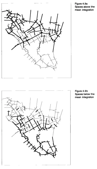
Figure 4.9a The spaces above the mean integration of the system 108
Figure 4.9b The space below the mean integration of the system 110
Figure 4.lOa Top 10% control spaces in the Suburb 110
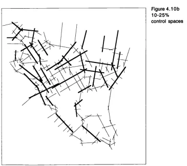
Figure 4.lOb 11-25% most control spaces in the Suburb 111
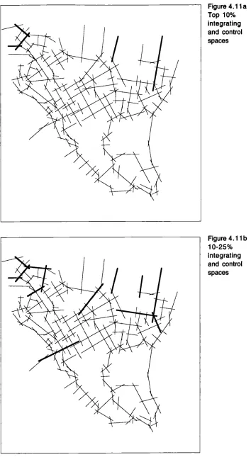
Figure 4.1 la Top 10% integrating and controlling spaces in the 112 Suburb
Figure 4.1 lb 11-25% most integrating and controlling spaces in the 112 Suburb
xviii
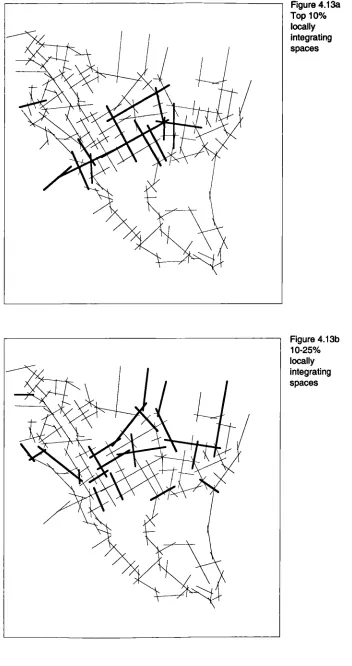
Figure 4.13a Top 10% integrating spaces in the Suburb 115
Figure 4.13b 11-25% most integrating spaces in the Suburb 115
Figure 4.13c 26-50% most integrating spaces in the Suburb 116
Figure 4. 13d 25% most segregating spaces in the Suburb 116
Figure 4.14a ToplO% control spaces in the Suburb 117
Figure 4.14b 11-25% most control spaces in the Suburb 117
Figure 4.15 Top 10% most integrating and controlling spaces in the 118 Suburb
Figure 4.16 Top 10% globally and locally integrating spaces in the 118 Suburb
Figure 4. 17a Local integration of the Suburb 121
Figure 4. 17b Local integration of the Suburb without surrounding 122 areas
Figure 4.18 Close-up of integration of the Suburb in the global 124 context
Figure 4.19 Two sub-areas in the Suburb 126
Figure 4.20a The Old Suburb area within its global context 126
Figure 4.20b The New Suburb area within its global context 126
Figure 4.21 The global integration of the sub-area A 128
Figure 4.22 Scattergram between global integration and local 128 integration in sub-area A
Figure 4.23 Global integration of sub-area B 129
Figure 4.24 Scattergram between global integration and local 129 integration in sub-area B
Figure 4.25 The Suburb's spine and its connections 133
Figure 5.1 Number of people in the sample by gender and age 139
XIX
Figure 5.2b The image of paths by segments 145
Figure 5.3 The image of landmarks, Hampstead Garden Suburb 146
Figure 5.4 Perceived core of Hampstead Garden Suburb 146
Figure 5.5 Superimposed boundary of the Suburb (whole sample) 149
Figure 5.6a Superimposed boundary of the Suburb (Sample A) 150
Figure 5.6b Superimposed boundary of the Suburb (Sample B) 150
Figure 5.7 Distribution of frequency of neighbourhood size 153
Figure 5.8 Perceived street layout of Hampstead Garden Suburb 154
Figure 5.9 Experience of the degree of getting lost for the two 154 samples
Figure 5.10 Comparison of spatial knowledge of the Suburb 154
Figure 5.11 General architectural legibility in the Suburb 154
Figure 5.12 Difficulties encountered in drawing a sketch map 159
Figure 5.13 Difficulties encountered in boundary delimitation 159
Figure 6.1 Scattergram between global integration and frequency 164 of appearance of elements
Figure 6.2 The most integrated spaces in human mind and their 174 syntactic properties in reality
Figure 6.3 The relationship between global integration, local 174 integration and the frequency
Figure 6.4 The frequency of the most integrated spaces on sketch 176 maps
Figure 6.5 Frequency and local integration 179
Figure 6.6 The frequency of appearance on sketch maps 180
Figure 6.7 Frequency and depth 181
xx
Figure 6.9 Scattergram between local integration of reality and 184 local integration of sketches
Figure 6.10 The effect of intelligibility on the association between 188 spatial configuration in reality and in the human mind
Figure 7.1 Average number of pedestrians per hour for all periods 193
Figure 7.2 Average number of vehicles per hour for all periods 194
Figure 7.3 Pedestrian movement 195
Figure 7.4 Vehicular movement 195
Figure 7.5 The distribution of movement through the day 196
Figure 7.6 The relationship between logged pedestrian movements 199 and logged vehicular flows
Figure 7.7 The vehicular pedestrian ratio against depth from the 199 peripheries
Figure 7.8 Regression analyses between spatial configuration and 201 the space use pattern
Figure 7.9 The association between normalised pedestrian 202 movement and depth from the periphery
Figure 7.10 The relationship between depth from the boundaries 204 and the amount of movement
Figure 7.11 Scattergram between local integration and normalised 206 pedestrian movement
Figure 7.12 Scattergram between normalised global choice and 206 normalised pedestrian movement
Figure 7.13 Distribution of hourly pedestrian flow and its 206 logarithmic transformation
Figure 7.14 Scattergram between local integration and normalised 208 vehic War movement
Figure 7.15 Scattergram between normalised choice value and 208 normalised vehicular movement
xx'
all movement
Figure 7.17 Scattergram between normalised choice value and 209 normalised all movement
Figure 7.18 The effect of intelligibility on the association between 214 spatial configuration and the space use pattern
Figure 8.1 The distribution of global and local integration of 220 sketch maps
Figure 8.2 Scattergram between the logged pedestrian movement 222 rate and the logged frequency
Figure 8.3 Scattergram between the logged vehicular movement 222 rate and the logged frequency
Figure 8.4 Scattergram between the logged all movement rate 222 and the logged frequency
Figure 8.5 Scattergram of logged pedestrian movement rate against 223 the local integration of sketch maps
Figure 8.6 Scattergram of logged vehicular movement rate against 223 the local integration of sketch maps
Figure 8.7 Scattergram of logged all movement rate against the 223 local integration of sketch maps
Figure 8.8 The effect of intelligibility on the association between 229 the frequency and movement rates
Figure 8.9 The effect of intelligibility on the association between 230 local integration of sketch maps and movement rates
Figure 9.1 The association among local integration, the frequency 242 and all movement rates
Figure 9.2 Two different view of outliers from the correlation 242 among the three variables
Figure 9.3 The correlation among local integration, normalised 245 frequency and normalised total movement for the
intelligible and the unintelligible area
xxii
lIltlOclUCtiOfl 1
Chapter One
INTRODUCTION
1.1 Aims and motives
Understanding the relationship between human beings and the built environment raises
the question of the impact of the built environment on human beings and the
characteristics of the interaction between them. More precisely, human spatial
experience appears to be shaped by spatial cognition and behaviour, interacting with
the physical built environment. To date, however, the role of spatial configuration has
not been properly incorporated into this research framework. The basic question of
this thesis is thus raised. How is spatial experience affected by spatial configuration,
and how do three domains - spatial configuration, spatial cognition and spatial
behaviour - interact with each other. This thesis addresses these issues according to a
series of specific questions. (1) What is the relationship between spatial configuration
and spatial cognition? (2) How far are the patterns of space usage characterised by
spatial configuration? (3) What are the underlying regularities in the relationship
between spatial cognition and space usage patterns? (4) What is the interaction among
these three domains? In each answer of these questions, how each relationship is
affected by morphological 'intelligibility" is also examined.
This thesis thus attempts to bring spatial, psychological and behavioural dimensions
into a single methodological framework. This framework is based on acquiring data
on residents' cognition in cognition and movement patterns of behaviour , coupled with
syntactic variables of spatial configuration by computer modeling.
This chapter addresses the basic arguments of this thesis, including how this research
relates to existing knowledge, and simultaneously how it differs from it. The first two
The intelligibility of an area (Hillier et al., 1987) is the degree of correlation between its local and globa' properties of spatial configuration. Section 1.5 and 2.3.4 address it in detail.
Iiiroduction 2
sections identify two main problems in carrying out this research. One is the lack of
understanding of spatial configuration in cognitive research (e.g., Downs and Stea,
1973). These studies explain spatial experience as being mediated by perception and
cognition. The other is the lack of understanding of spatial cognition in studies
examining the impact of spatial configuration on spatial behaviour (e.g., Hillier et al,
1993). After this, the latent possibility of morphological intelligibility is discussed as a
suggestive factor for shaping spatial experience. Considering these problem
definitions, an integrated approach is proposed, which benefits from the two fields: the
syntactic description of spatial configuration and knowledge accumulated by research
on spatial cognition. Finally, the overall structure of the remainder of the thesis is
presented.
1.2 The lack of understanding of spatial configuration in cognitive studies
Spatial-temporal reasoning is a basic function in people's daily life. People employ it
almost constantly to infer information about their environment and about their
changing location in space. Our knowledge of the spatial environment and the way in
which we visualise and symbolise it, is a consequence of our experience in it and with
it.
A few studies has identified the salient role of spatial configuration in human spatial
experience (e.g., Garling et al, 1986). Many researchers address the importance of
cognitive representation in spatial experience. For example, Zimring (1981) reviews
relevant research and contends that environmental forms that encourage acquisition of
accurate cognitive representations reduce stress. At a more empirical level O'Neill
(1991) suggests that higher levels of configurational understanding are generally
associated with more efficient wayfinding performance.
The process of cognitive mapping and the map itself has been used as a research tool
to measure how people perceive and recognise their built environment and how people
act in it. These studies are valuable in providing data on differences in the ways in
which individuals, and perhaps groups, recognise their environment.
lfltFOdUCtlOfl 3
However concern in this area has focused on individual or group differences in
cognitive mapping ability in laboratory settings or in fieldwork, which restricts the
parameters available for analysis. In addition, conventional analysis of cognitive maps
has concentrated on the clisaggregation of represented elements (e.g., Lynch, 1960).
Cognitive studies provide us, therefore, with a useful method, but not with a
theoretical starting point for an inquiry into the human being and built environment
relationship. This appears to be primarily caused by the absence of a methodological
tool to describe both objective configurations in reality and subjective ones in cognitive
representations. There thus have been gaps in understanding and describing
configuration as a total field of the interrelation of elements, patterns and sequences.
Hart and Moore (1973) argue that, even though psychologists and geographers alike
converge in treating the understanding of spatial configuration as the ultimate stage of
spatial cognition, configuration is perhaps the most difficult aspect of the environment
to describe in an objective and analytical manner. Methods that have been used to date
in analysing cognitive maps thus seem to have failed to describe the internal
representation of spatial configuration systematically. The absence of a proper method
for studying cognitive representation appears to constrain exploration of the
information that is contained in it. Thus the cognitive approach reveals gaps in our
knowledge of human spatial experience without relating the likely effect of spatial
configuration on that experience.
In order to describe and analyse the role of spatial configuration in the cognitive
representation, a more flexible and analytic method may be needed. If this were
available then we would be able to understand cognition of the built environment in
association with spatial configuration, since it may encourage and/or impede its
cognitive representation.
1.3 The implication of cognitive studies for the syntactic approach
Hillier and Hanson (1984) contend that the social implication of building plans and
settlement layout should be seen not only as something imprinted in human
Introduction 4
subjectivity, but also as something constituted in space. They define conventional
studies investigating the man-environment relation as those in which the physical
environment has no social content and society has no spatial content. Hillier (1996)
reiterates this man-environment relation as not a direct physical relation of cause and
effect, but as an indirect relation, mediated by spatial configuration. He further
proposes a theory in which we find pattern effects from space to people and from
people to space.
From this theoretical background, Hillier and his colleagues developed a descriptive
theory of space, Space Syntax 2 . Space syntax not only suggests an effective
conceptual framework for investigating the man and built environment relation, but
also a method for describing spatial configuration as collections of local elements and
as an interrelated whole.
Syntactic analysis of spatial configuration coupled with extensive empirical observation
of people's space use patterns, has explained how complex buildings and urban areas
work. Thus it provides information on spatial configuration and its possible
consequences on the surrounding area, in terms of space use and movement. This
enables further analysis using a computer model to predict how a new design will
affect existing spatial patterns both globally and locally. The syntactic approach thus
seems to offer better solutions to overcoming problems in conceptualising relations
between spatial form and social life, and in describing such relations in spatial terms.
This work has a substantial relevance to the present work, but does not provide the
starting point for this dissertation, since there is a fundamental difference in how the
problem is conceptualised in research investigating the human being and built
environment relation. Most work to date using the syntactic approach has attempted
to show how buildings and settlements help to constitute society through the way in
which configurations organise space. However, they have not claimed an impact of
spatial configuration on cognitive representation, which might play a key role in the
2
Space syntax is a set of concepts and quantitative measures for representing the topological properties in spatial layout. Basic concepts and procedures are described in section 3.2.
lfltIO(lUctiOfl 5
relation. Despite many conjectures on the effect of spatial configuration on the human
mind, this cognitive aspect has been largely neglected within syntactic studies. Also,
the syntactic approach to the understanding of spatial behaviour has focused on the
relationship between configuration and its consequent behaviour, without claiming a
role for spatial configuration in cognition.
In this context the cognitive approach is valuable to this syntactic approach. Downs
and Stea's (1973) contention that the 'cognitive map' is a pre-requisite both for human
survival and for every day behaviour is noteworthy, since behaviour is dependent on
the individual's 'cognitive map'. This is understood as the basis for deciding upon and
implementing any strategy of spatial behaviour. O'Neill (1991) also contends that
configurational knowledge, which plays a decisive role in wayfinding, may be assessed
by the ability to draw accurate sketch maps. These works show clearly the need for an
inquiry into spatial cognition for an in-depth understanding of the relationship between
configuration and the behaviour.
The problems described in section 1.2 and in this section can be summarised as that
there has been little proper attempts to understand the impact of spatial configuration
in cognitive representation quantitatively in spite of its likely significance at the
psychological level. The importance of an individual's subjective internal
representation of the spatial configuration has hitherto remained unexplored in both
cognitive studies and syntactic approaches.
1.4 Intelligibility and its possible role in shaping spatial experience
Kevin Lynch (1984) contends that space suggests action as well as constraining it.
Earlier, Lynch (1960) defines 'legibility' as the ease with which a system's parts can be
recognised and can be organised into a coherent pattern. He states that if a city is
legible it can be visually grasped as a related pattern of recognisable symbols, so a
legible city would be one whose districts or landmarks or pathways are easily
identifiable and are easily grouped into an over-all pattern. He further argues that in
the process of wayfinding, the strategic link is the environmental image, a generalised
IflIr()d ictiofl 6
mental picture of the exterior physical world which benefits from architectural legibility
as experienced by an individual. He defines this characteristic as 'imageability'. Based
on this conjecture, he suggests that legibility may play a decisive role in acquiring a
sense of spatial control.
In supporting Lynch's argument, Kaplan and Kaplan (1983) contend that legibility is
one of the most salient aspects essential to an individual's effective functioning, since it
allows one to explore extensively without becoming lost. In a similar vein Garling et al
(1986) proposes a model of preferable spatial forms that may affect spatial orientation
and navigation through perception and cognition. Garling's study is unique in that the
concern for legibility is shifted to a systematic description of spatial configuration that
is not conceivable by Lynchian methodologies. These three examples of studies have a
common approach that emphasises more abstract and affective qualities of spatial form
rather than an objective and analytic description of it.
Hillier seems to have a similar theoretical stance regarding the role of the built
environment. However, his approach is quite different to the studies defined above.
Hillier et al (1987) propose a syntactic definition of intelligibility to describe this
qualitative aspect of spatial form analytically and quantitatively. It is his contention,
although there are few direct empirical findings, that intelligibility is related to the
capacity of a space to give clues to the understanding of the whole system. Hillier
develops a metric for intelligibility by correlating a local measure of spatial
configuration with a global measure. He defines intelligibility as the relationship
between these two such that where you are locally in a system may provide you with
sufficient clues as to where you are globally in the whole system. Thus it may be
possible to predict the spatial structure of a whole settlement, if it has high
intelligibility, from spatial relations held in local parts. Hillier (1996) argues that urban
design problems are exactly this part-whole problem.
He develops these ideas and suggests that intelligibility is a 'generic function' that
permits a spatial complex to be adapted for human occupation and movement. He
proposes that intelligibility supports this generic function of spatial structure.
Jntroductiu,i 7
Anticipating Hillier's conjecture of intelligibility, Steadman (1983) argues that
morphological intelligibility might be an important factor promoting or restricting
architectural possibility. Hanson (1991) conjectures that the sociological potential of
intelligibility is that it might lead to a stronger movement interface between inhabitants
and strangers.
Supporting these hypotheses, Penn and Dalton (1994) suggest that the human mind
may in effect be a correlation detector searching for perceptual information from the
local spatial configuration in order to predict global location. They thus conjecture
that if the mind has a problem with making sense of these data, it is because the
correlation has broken down. They suggest that the unconscious process of recalling a
'map' in the human mind is essentially the search for correlations between factors as
people move through space.
All these conjectures regarding the role of intelligibility require empirical investigation
at the psychological level, which is not yet available. Such findings would allow the
incorporation of this extended notion of intelligibility into a research framework
investigating the relationship between man and the built environment.
1.5 Two conjectures: the need to expand theories of the built environment
and behaviour
Cognition and spatial behaviour may be linked to the spatial configuration of individual
areas and to the way that spatial properties of each area interact with surrounding
areas. This conjecture is intended to explain the interrelationship between and among
spatial configuration, cognitive representation and patterns of space use.
It is hypothesised that spatial configuration may affect cognition, which contains
configurational knowledge. The acquisition of this knowledge may also be affected by
variations in spatial configuration. Then this knowledge in turn may cause differences
in spatial behaviour in daily life. If an association exists between them, account must
be taken of the role of the salient aspect of spatial configuration - intelligibility. The
mu OdUCtiOfl 8
hypotheses regarding intelligibility are; i) it may be the intervening variable, which
influences interaction within the framework; ii) it may facilitate a clear image of spatial
layout, thus people who live in an intelligible area may have better legibility of spatial
layout than those in an unintelligible area. At the same time, they may have a more
intelligible cognitive map of the whole area.
The same hypothesis applies to the relationship between configurational properties and
patterns of space use, and between cognitive representation and patterns of space use.
The former emphasises whether intelligibility leads to a stronger association. The
latter aims to build a theoretical bridge to the association between spatial cognition and
spatial behaviour.
Considering this series of hypotheses, intelligibility may affect and characterise the
interactive process of the interface between man and the built environment. Figure 1.1
illustrates the general conceptual hypothesis regarding the role of intelligibility in the
present study.
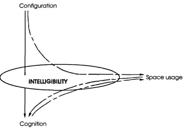
Configuration
II'
INTEWGIBIUF( Space usage
Cognition
Figure 1.1 The intelligibility and spatial experience interface
ItltrOdUCtiOfl 9
If configurational factors are found to be influential in these interactions, different
types of spatial configuration may lead to a totally different spatial experience. This
would provide empirical grounds to assert that, for architectural practice, one should
incorporate knowledge of spatial configuration and its implications into design
rationales. This research attempts to clarify some of these intricate issues which are
part of the dialogue between form and function in architecture.
1.6 The need for an integrated approach to spatial configuration, spatial
cognition and spatial behaviour
Some attempts have been made to understand these three domains from an integrated
perspective. They provide us with a useful conceptual framework for investigating
their relationship (e.g., Evans and Garling, 1991; Garling, 1995). Nevertheless, the
salient role of spatial configuration has not been incorporated in that research agenda.
Both aspects of spatial configuration - in the real world and in cognitive representation
- seem to be required for any adequate theoretical understanding. These aspects might
receive their proper recognition if they are understood in terms of an interactive
process composed of the three 'moments' of configuration, cognition and behaviour.
As far as the behavioural phenomenon is concerned, this process does not seem to be
thought of as occurring discretely. Individual spatial behaviour is likely simultaneously
to recognise spatial configuration as an objective reality and to represent and activate it
as a cognitive map for action in the environment. Behavioural consequences and each
part of them seem continuously to communicate in these three moments. Therefore
any analysis in terms of only one or two of them may fall short.
This thesis adopts three methodologies. First, in order to analyse and understand
spatial configuration in reality and in cognitive representations, Space Syntax was
utilised. Second, an interview survey was conducted to gather data about cognition,
along with sketch mapping. Third, an intensive observation of overt spatial behaviour
was carried out to acquire information on space usage patterns. The latter two
lIlIFodUCtiofl 10
methods aim to acquire data on both 'stated' and 'revealed' aspects of spatial
cognition.
Thus, syntactic descriptions of spatial configuration coupled with both interview
survey and observation, permit an investigation into the way the three domains interact
within the overall research framework. The findings provide us with information on
human spatial experience, along with the possible role of spatial configuration within
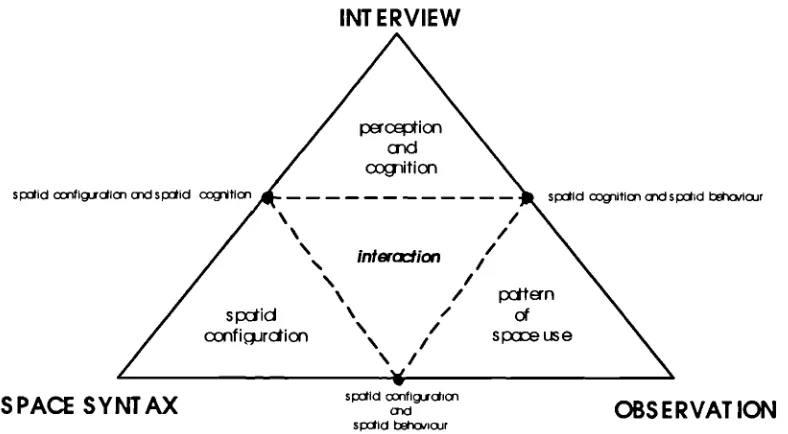
the framework. These relationships are summarised in Figure 1.2.
INTERVIEW
pcqia md ccgitim
sid figjcElcn aid sid cxitia
/
intcrcrtion
s id olojr
/,
/
/ xtten
s rxiid of
/ spreuse \ /
ccnfiqjrdlon
/
sxiid ifscjpi
S PACE S Y NT AX OBS E RVAT ION
siid iicjr
Figure 1.2 The research framework
1.7 Outline of the dissertation
In Chapter two, literature on relevant theoretical positions and research frameworks
about human spatial experience is introduced. The interface between spatial
configuration and spatial behaviour is set out, beginning with a discussion of notions
such as 'legibility' and 'intemalising spatial configuration'. Next, studies regarding
spatial configuration and its consequences for space usage are addressed. The
acquisition and the nature of spatial knowledge are then reviewed, since this
Introduction 11
constitutes the most important factor in spatial cognition. A review of the literature on
cognitive mapping and its end product of the 'cognitive map' are also covered.
Considering these findings, the use of cognitive maps as a research tool is proposed,
along with the possibility of their syntactic analysis. Thus the possible use of sketch
maps in measuring configurational knowledge is identified, and theoretical grounds for
applying syntactic description directly to these representations are provided.
This review goes on to consider links between cognitive maps and spatial behaviour,
through the investigation of the relationship between sketch maps and space use
patterns. The next section discusses a conceptual framework, which synthesises the
three fields that have operated largely in isolation from one another to date. The
argument of chapter two concludes by going back to the problem of intelligibility and
its incorporation into this research framework.
Chapter three begins by describing three methodologies employed; 'Space syntax' for
spatial analysis, interview survey for measuring residents' perception and cognition,
and gate observations for gathering information on space usage patterns. These
methods eventually enable an integrated investigation of relations among design
parameters, the image of a place in the cognitive dimension and patterns of space
usage in the behavioural sphere.
These sections are followed by an overall view of the organisation of data, and its
processing procedures and an outline of the statistical tests employed. Next, a new
way for analysing configurational knowledge in sketch maps is presented. This is
followed by the neighbourhood definition applied in this study. Finally, the study area
is introduced.
Chapter four aims to understand the spatial morphology of Hampstead Garden Suburb
as a whole system of spaces and buildings constituting a pattern, using syntactic
descriptions. The chapter starts by introducing the historical development and design
concepts of the Suburb. Coupled with a general morphological overview of the area,
the spatial layout of the Suburb is described in-depth and its spatial realisation in terms
lfltfl)dUCtiOfl 12
of its degree of intelligibility is investigated. Thus, the suburb is subjected to a
thorough investigation, first focusing on the pattern of its spatial layout within its
global context, and then, on the area itself without its surroundings. These two ways
of looking at the spatial structure, one as an interwoven part of the whole, and the
other as a distinct structure, allow a discussion about the spatial experience produced
by its spatial configuration. Two halves of the Suburb are identified by these analyses.
One is a relatively intelligible area and the other is less so.
Chapter five presents interview data on residents' perception and cognition of the
Suburb: firstly, the characteristics of spatial configuration in sketch maps; secondly the
boundaries of the perceived neighbourhood; and thirdly, general findings about the
perception and cognition of the Suburb. These findings are systematically compared
between samples from the two halves of the Suburb to investigate likely effect of the
intelligibility of the area in which they reside. These findings feed back into the
discussion of the role of intelligibility and the extension of its current definition, and
provide preliminary grounds for the incorporation of it into the conceptual framework,
developed in chapter two.
The findings of chapters four and five, coupled with the observed movement patterns
provide information that allows extensive scrutiny between and among the three
domains of cognition, behaviour and space. The following three chapters are therefore
on the relationships between: spatial configuration and spatial cognition; spatial
configuration and spatial behaviour; and spatial cognition and spatial behaviour.
In Chapter six, an investigation is made of the relationship between configurational
characteristics of the spatial layout and the spatial cognition of residents as revealed in
chapter five. The intention here is to isolate significant regularities in this relationship.
The issues covered are: first, the relationship between respondents' cognition of the
area and the syntactic attributes of their residential location; second, the syntactic
characteristics of their intemalised configurations; third, the association between the
internalised configuration in sketch maps and the configuration in reality; and fourth, a
comparison of spatial configurations in reality and in sketch maps.
lfltfl)dUCtiOfl 13
The findings provide strong empirical support for hypothesised psychological effects of
spatial configuration. These revealed regularities enable a discussion about the
systematic effects of spatial configuration on spatial cognition. They initiate the
theoretical debate between objective 'intelligibility' and subjective 'imageability'. In
other words, this brings two dimensions - objective configuration and its subjective
cognition - to the main argument of the thesis.
Chapter seven investigates the relationship between spatial configuration and spatial
behaviour. There is a body of research on this topic that shows a positive relationship
between them. This chapter thus is not intended to reconfirm these findings, rather it
is more focused on how intelligibility affects this association in this purely residential
area. In this context, an attempt has been made to ascertain whether there is a contrast
in space use patterns between the intelligible and the unintelligible parts of the Suburb.
This chapter thus raises theoretical questions as to how the psychological aspects of
intelligibility affect the relationship between spatial cognition and space use patterns.
This relationship seems to be unexplainable with reference only to spatial variables and
movement patterns alone. This issue is addressed in chapter eight, which tackles the
association of spatial behaviour with cognitive variables in sketch maps.
Chapter eight attempts to incorporate a cognitive dimension into the behavioural
domain by investigating the relationship between cognitive representations of the
spatial configuration and the pattern of space use. Then it extends the discussion to
the role of intelligibility in this association. Based on perception and cognition in
Chapter five and the observed movement patterns in chapter seven, systematic
exploration of the likely interdependence between the two variables is carried out.
Chapter nine attempts to investigate the interaction among three variables, which has
been examined at the individual level or only partially synthesised in the previous
analysis chapters. This chapter is focused on understanding how configuration
influences cognition and behaviour, and how spatial cognition interacts with space use
patterns. In this context, the chapter aims not only to integrate our understanding of
these three domains but also to interpret each one within the perspective of the whole
lntn)duciofl 14
framework. This is attempted, firstly by describing the interaction between and among
three domains, focusing on the ways in which configuration, spatial cognition and
spatial behaviour co-vary within the system. Secondly, a conceptual framework
interfacing spatial configuraiton-spatial experience relation is proposed through the
identified interaction between and among these three domains.
This chapter identifies intelligibility as an intervening factor promoting the process in
the proposed 'spatial configuration-spatial experience interface'. It proposes that
intelligibility influences the interaction between spatial cognition and spatial behaviour
including the feedback process of spatial behaviour to spatial cognition. Finally, an
extended concept of intelligibility is discussed.
The dissertation ends with a discussion of findings and their implications in Chapter
ten. The empirical results of this study are subjected to a synoptic review and
interpretation, with reference to the questions and hypotheses posed earlier in this
thesis. This leads to a discussion of intelligibility and the incorporation of its extended
conception into design rationales. An attempt is then made to discuss the proposed
framework in architectural theories. The thesis finishes by proposing the notion of
'architectural intelligibility', which may be a basic human need for securing a sense of
autonomy in spatial experience.
Incorporation of tnt 'IIiihiJ it into Hun an-en' ironment Pai adi'ni 15
Chapter Two
INCORPORATION OF SPATIAL CONFIGURATION INTO
HUMAN-ENVIRONMENT RESEARCH FRAMEWORK
2.1 Introduction
This thesis aims to investigate the interaction between and among spatial
configuration, spatial cognition and spatial behaviour. The reviews of literature
in this chapter reflect this goal. Its purpose is to clarify the extent to which
previous studies have contributed to an understanding of the interaction between
man and the built environment and to identify any approaches and methodology
that seem to be relevant to this thesis. The literature about spatial cognition and
their associated spatial behaviours are all important to an understanding of the
man! built environment relation, however they are reviewed selectively, since
the current research is more focused on the incorporation of the role of spatial
configuration into man/built environment studies.
The review is in three parts. The first three sections 2.2 - 2.4 attempt to identify
the general understanding of spatial cognition, cognitive maps, and the
relationship between cognitive maps and spatial behaviour. The studies are
examined from the perspective of the way the impact of spatial configuration is
understood in these areas. This issue is deeply related to the question of how to
incorporate the notion of spatial configuration into the man-built environment
research framework.
While the first part outlined above raises mostly questions of how spatial
configuration is examined in cognitive approaches in explaining spatial
behaviour, the second part focuses on notion of cognitive maps. These play a
salient role in every day spatial behaviour, and are considered as a contributing
factor in syntactic studies. This approach places spatial configuration as the
Incorporation of Intclhgihil it\ into Human-ens ii onment Paradiru 16
most salient mediating factor in the man-environment interface. Sections
2.5-2.7, therefore, review theories and studies of how a syntactic approach explains
spatial behaviour, including its implications for understanding human spatial
experience.
The final part reviews integrative research linking the first two approaches. It is
in three sections. First, section 2.8 asks how previous research and theory have
attempted to interpret interaction among configuration, cognition and behaviour.
This review is of particular importance in structuring the framework for this
thesis by identifying how cognitive and syntactic approaches can be combined to
contribute for better understanding of man-built environment interaction.
Sections 2.9 and 2.10 review the way spatial configuration has been incorporated
into the man-built environment research framework. It proposes that the notion
of 'intelligibility', as defined by Hillier et al (1987) could contribute an
intermediate factor in the relationship between human beings and their
environment. The structure of this literature review is illustrated in Figure 2.1.
PART ONE:
SPATIAL COGNITION, COGNITIVE MAPS, AND SPATIAL BEHAVIOUR
2.2 Acquiring spatial knowledge
2.2.1 Process of spatial learning
Human beings relate to the physical built environment through the psychological
processes of perception and cognition. Burnett (1976) asserts, in examining the
relationship between human beings and their environment, that perception and
cognition are recognised as intervening psychological processes, a filtering
mechanism in human action in the environment. Perception is the act of
apprehending through the mind and senses, of observing, of being aware. It is
closely connected with events in the immediate surroundings and is linked with
immediate behaviour.
r—
I,-)
C"
E- .9 C/) a) > a) a) Ca a) 4-. 0 a) 4-. 0 4-. (I) c'j a) 1 0) U-z
0
(J)Z C!3 z >-0 C/) ri 00 0 = oca ra -o Q_ C (J)ca C 0 Ca C) C 0 0 Ca 0 C/) 0 Ca -c a) -o Ca Ca 0 C,) -c C-) 0 > 0 .0 a) 0) > a) C 0) a) C 0 c'J cz
o
- >
ow
Oco
I-< I-<
ci
o
Cl) Cl)
Incorporation of line!! igi hi! ity into Hurnan-en ironment Pard im 18
Psychologists have tended to treat perception as a sub-set or function of
cognition, which is the act or faculty of knowing, of consciously gaining and
storing new information in the memory. Figure 2.2 illustrates that spatial
information as filtered through a psychological filter, which results in images
and behaviour.
rnal
Brain >
EBehI:ur
L::_rJ
Figure 2.2 The formation of images and behaviour in psychological studies
In a similar vein, Golledge and Stimson (1997) identify the work of
psychological processes as an interface between the environment and human
behaviour. They note that:
"We may perceive the Street where we live by physically being there, but
knowing the route depends on cognitive organisation of a set of
perceptions experienced through frequent travel" (p1 90).
Such processes involve a mixture of attitudes towards the environment,
perception and cognition, and learning. This approach suggests that the
understanding of spatial structure in the built environment is a cognitive process
based on sets of perceived information.
2.2.2 Development of spatial knowledge
Incorporation of Intelligibility into Human-environment P'iradigm 19
In the development of qualitative spatial learning, Piaget and Inhelder (1975)
contend that children's spatial learning develops from an understanding of
topological relations to projective, and ultimately to Euclidean concepts.
On the other hand, Siegel and White (1975) describe the sequence of spatial
learning from an ability to identify landmarks, to an integration of knowledge
about the routes linking individual landmarks, and finally to an understanding of
abstract spatial relations in a survey representation. They define route
knowledge as the knowledge of how to go from one location to another, without
definitive knowledge of the relative positions of locations. In other words, it is
characterised by the knowledge of sequential locations without the knowledge of
general interrelationships. The most developed spatial knowledge is
'configuration or survey knowledge', that is, a 'cognitive map', which is
knowledge of the relative locations of objects in the environment. From the
cognitive map, landmark and route information can be derived, even for routes
never before travelled. Configurational knowledge is thus affected by the ability
to generalise beyond learned routes and locate objects within a general frame of
reference. However, configurational knowledge is relatively less clearly defined
and generally refers to the individual's ability to traverse complicated
configurations of paths and nodes within some external frame of reference,
including an ability to find new routes between nodes without getting lost.
On the development of configurational knowledge in cognitive maps, Golledge
(1975) proposed an anchorpoint theory in which a hierarchical ordering of
locations, paths, and areas within the general spatial environment is based on the
relative significance of each to the individual. He continues that both node and
path knowledge are organised hierarchically with primary, secondary, tertiary,
and lower order nodes and paths forming a skeletal structure upon which
additional node, path, and aerial information are grafted. Thus neighbourhoods
surrounding the primary node set become known first, and continued interactions
along developing node-path networks strengthen the image of segments of the
environment for each individual at the same time as they formalise the content
and order the basic common knowledge structure.
Incorporation of EntcIIiihi it into Human-cn ironment Parddigm 20
The relative development of spatial knowledge may vary both with the particular
spatial environment and individual ability. Heft and Wohlwill (1985) have
reiterated the importance of invariant cues in the environment that provide direct
information about the identity and spatial position of objects as well as their
functional purpose or meaning. They contend that even when individuals have
similar levels of exposure to a place, their internal cognitive representations and
their qualitative reasoning about the place will differ. Thus not only the type of
orientation cues used by individuals but also their subsequent spatial behaviour
may depend both on the existing spatial configuration of the setting as well as on
the needs, experiences, and goals of the individual.
Given current knowledge and the set of assumptions described above, it is
possible to hypothesise that an individual's spatial knowledge acquired through
spatial learning may be categorised as simple quantitative and complex
qualitative knowledge. The former refers to the amount of information without
organisation of each element, and the latter to how this information is
interrelated to create an understanding of the built environment. Both spatial
knowledge and reasoning about spatial layout are related to the degree of
complexity or cohesion of the configuration of spatial elements.
2.2.3 Measuring spatial knowledge
The dimension of spatial knowledge includes: information on recalling and
representing layouts; connecting locations; wayfinding in real-world
environments; landmark cognition; orientation; sketch mapping and many
others. Generally, spatial knowledge has been tested by such means as
wayfinding ability, direction estimates, distance estimates, sketch maps'.
Wayfinding refers to a person's cognitive and behavioural abilities to determine
the path between a specified origin and destination and to successfully negotiate
the path. For successful travel, information must be obtained about the reference
'Sketch maps are explained in detail in sections 2.3-2.5.
Incorporation of hit Hi g ihiIit into Human en ironment Prdi'ni 21
point used to identify start, end, and current location, cues that signal when
changes of direction are required, recognition of the appropriate turn angle that
links consecutive segments, and a mechanism for determining where one is at
any particular point in time with respect to the origin.
Spatial orientation refers to the ability to imagine how configurations of
elements would appear from different perspectives. This involves a person's
ability to relate personal location to environmental frames of reference. These
frames of reference might be local and relational as with respect to landmarks or
street systems, or they might be related to a global and widely accepted frame of
reference such as traditional geographic latitude and longitude correlated systems
and the cardinal compass directions. Thus spatial orientation is seen to be an
important component of the larger process of spatial knowledge. It is also
important in wayfinding and navigation.
Riser et al (1982) suggest that the major components of spatial orientation
include:
i) Knowledge of spatial layout of destinations and landmarks along the
way.
ii) The ability to keep track of where they are and in which direction they
are leading.
iii) Comprehension of the organising structural principles embedded in a
given environment.
Cognitive distance describes the relative spatial separation of objects in a
cognitive map. It is accepted that generally cognitive distances may be
asymmetric and that, in some cases, the distances may be interpreted in a
functional, proximity, or similarity context rather than in a geometrical one. For
example, Baird et al (1982) have suggested that, given the asymmetric nature of
cognitive distance, its representation may be impossible in any known geometric
space.
Incorporation of IntI I i g ihi 1 it\' into Human-ens I ronment Parad im 22
Montello (1991) suggests that we should be aware of the following four
difficulties associated with cognitive distance studies:
i) The ratio calculation problem. Substantial differences may exist among
individuals in their ability to determine the ratio between the length of a
standard distance and the length of a test distance.
ii) The scale translation problem. This might occur when the standard
distance in an environment is represented by an arbitrarily scaled length of
line to make the appropriate estimate; a subject must be able to perform the
scale translation between the given standard and the real-world standard
before a legitimate result can be achieved.
iii) The problem of bias. Giving a standard distance with certain lengths
provides no guarantee that all subjects will internally represent the
standard as being of equivalent length.
iv) The orientation problem. This may occur when the standard line is
given in an orientation different to that normally experienced with respect
to the usual frames of reference used in the environment. Vertical lines
often appear longer than horizontal lines (i.e., vertical illusion). Aligning
standards with real-world occurrences helps to reduce this type problem.
In addition to the measurements of spatial knowledge outlined above, landmark
knowledge is usually assessed by asking observers to recognise or recall the
landmarks that they have seen along a route.
2.3 Cognitive mapping in spatial cognition
2.3.1 Spatial cognition and cognitive maps
Hart and Moore (1971) define spatial cognition as the knowing of, and internal
or cognitive representation of the structure, entities, and relations of space; in
other words, the intemalised reflection and reconstruction of space in thought.
Concurring with this view, Downs and Stea (1973) note that this is the process
by which the individual acquires, codes, stores, recalls and decodes information
about the relative location and attributes of phenomena in the every day spatial