www.earth-syst-sci-data.net/8/383/2016/ doi:10.5194/essd-8-383-2016
© Author(s) 2016. CC Attribution 3.0 License.
A multi-decade record of high-quality
f
CO
2
data in
version 3 of the Surface Ocean CO
2
Atlas (SOCAT)
Dorothee C. E. Bakker1, Benjamin Pfeil2,3, Camilla S. Landa2,3, Nicolas Metzl4, Kevin M. O’Brien5,6, Are Olsen2,3, Karl Smith5,6, Cathy Cosca5, Sumiko Harasawa7, Stephen D. Jones2,3,
Shin-ichiro Nakaoka7, Yukihiro Nojiri7, Ute Schuster8, Tobias Steinhoff9, Colm Sweeney10,11, Taro Takahashi12, Bronte Tilbrook13,14, Chisato Wada7, Rik Wanninkhof15, Simone R. Alin5, Carlos F. Balestrini16, Leticia Barbero15,17, Nicholas R. Bates18,19, Alejandro A. Bianchi16,
Frédéric Bonou20, Jacqueline Boutin4, Yann Bozec21, Eugene F. Burger5, Wei-Jun Cai22, Robert D. Castle15, Liqi Chen23,24, Melissa Chierici25,26, Kim Currie27, Wiley Evans5,28,29,
Charles Featherstone15, Richard A. Feely5, Agneta Fransson30, Catherine Goyet31,32, Naomi Greenwood33, Luke Gregor34, Steven Hankin5,6, Nick J. Hardman-Mountford35,
Jérôme Harlay36, Judith Hauck37, Mario Hoppema37, Matthew P. Humphreys19, Christopher W. Hunt38, Betty Huss15, J. Severino P. Ibánhez39,20, Truls Johannessen2,3,40, Ralph Keeling41, Vassilis Kitidis42, Arne Körtzinger9, Alex Kozyr43, Evangelia Krasakopoulou44, Akira Kuwata45, Peter Landschützer46, Siv K. Lauvset40,2, Nathalie Lefèvre4, Claire Lo Monaco4, Ansley Manke5, Jeremy T. Mathis5, Liliane Merlivat4, Frank J. Millero47, Pedro M. S. Monteiro34,
David R. Munro48, Akihiko Murata49, Timothy Newberger10,11, Abdirahman M. Omar40,2, Tsuneo Ono50, Kristina Paterson13, David Pearce33, Denis Pierrot15,17, Lisa L. Robbins51, Shu Saito52,
Joe Salisbury38, Reiner Schlitzer37, Bernd Schneider53, Roland Schweitzer54, Rainer Sieger37, Ingunn Skjelvan40,2, Kevin F. Sullivan15,17, Stewart C. Sutherland12, Adrienne J. Sutton5,6, Kazuaki Tadokoro45, Maciej Telszewski55, Matthias Tuma56, Steven M. A. C. van Heuven57,
Doug Vandemark38, Brian Ward58, Andrew J. Watson8, and Suqing Xu23
1Centre for Ocean and Atmospheric Sciences, School of Environmental Sciences, University of East Anglia,
Norwich NR4 7TJ, UK
2Geophysical Institute, University of Bergen, 5020 Bergen, Norway 3Bjerknes Centre for Climate Research, 5007 Bergen, Norway
4Sorbonne Universités (UPMC, Univ Paris 06), CNRS, IRD, MNHN, LOCEAN/IPSL Laboratory,
75005 Paris, France
5Pacific Marine Environmental Laboratory, National Oceanic and Atmospheric Administration, Seattle,
WA 98115, USA
6Joint Institute for the Study of the Atmosphere and Ocean, University of Washington, Seattle, WA 98105, USA 7National Institute for Environmental Studies, Tsukuba, Ibaraki, 305-8506, Japan
8College of Life and Environmental Sciences, University of Exeter, Exeter EX4 4QE, UK 9GEOMAR Helmholtz Centre for Ocean Research Kiel, 24105 Kiel, Germany 10Cooperative Institute for Research in Environmental Sciences, University of Colorado, Boulder,
CO 80309, USA
11Earth System Research Laboratory, National Oceanic and Atmospheric Administration, Boulder,
CO 80305-3337, USA
12Lamont Doherty Earth Observatory, Columbia University, Palisades, NY 10964, USA 13CSIRO Oceans and Atmosphere, Hobart, Tasmania 7001, Australia
14Antarctic Climate and Ecosystems Cooperative Research Centre, University of Tasmania, Hobart,
Tasmania 7001, Australia
15Atlantic Oceanographic and Meteorological Laboratory, National Oceanic and Atmospheric Administration,
16Departemento Oceanografía, Servicio de Hidrografía Naval, C1270ABV Buenos Aires, Argentina 17Cooperative Institute for Marine and Atmospheric Studies, Rosenstiel School for Marine and Atmospheric
Science, University of Miami, Miami, FL 33149-1098, USA
18Bermuda Institute of Ocean Sciences, Ferry Reach, St. Georges, GE01, Bermuda 19Ocean and Earth Science, University of Southampton, Southampton SO14 3ZH, UK
20Centro de Estudos e Ensaios em Risco e Modelagem Ambiental, Universidade Federal de Pernambuco,
50740-550 Recife, Brazil
21Sorbonne Universités, UPMC Univ Paris 06, CNRS, Adaptation et Diversité en Milieu Marin (UMR7144),
Station Biologique de Roscoff, 29680 Roscoff, France
22School of Marine Science and Policy, University of Delaware, Newark, DE 19716, USA 23Key Laboratory of Global Change and Marine-Atmospheric Chemistry, Third Institute of Oceanography,
State Oceanic Administration, Xiamen, 361005, China
24Chinese Arctic and Antarctic Administration, Beijing, 100860, China 25Institute of Marine Research, 9294 Tromsø, Norway
26Department of Marine Sciences, University of Gothenburg, 40530 Gothenburg, Sweden 27National Institute of Water and Atmospheric Research, Dunedin 9054, New Zealand
28Ocean Acidification Research Center, University of Alaska Fairbanks, Fairbanks, AK 99775-7220, USA 29Hakai Institute, British Columbia V0P 1H0, Canada
30Norwegian Polar Institute, Fram Centre, 9296 Tromsø, Norway 31IMAGES_ESPACE-DEV, Université de Perpignan, 66860 Perpignan, France 32UMR ESPACE-DEV, Maison de la teledétection, 34000 Montpellier, France 33Centre for Environment, Fisheries and Aquaculture Science, Lowestoft NR33 0HT, UK
34Ocean Systems and Climate, CSIR-CHPC, Cape Town, 7700, South Africa 35CSIRO Oceans and Atmosphere, Floreat, Western Australia 6014, Australia 36University of Hawaii at Manoa, Department of Oceanography, Honolulu, HI 96822, USA 37Alfred Wegener Institute Helmholtz Centre for Polar and Marine Research, 27515 Bremerhaven, Germany
38Ocean Process Analysis Laboratory, University of New Hampshire, Durham, NH 03824, USA 39IRD – Institut de Recherche pour le Développement, Lago Sul, 71640-230 Brasilia, Brazil
40Uni Research Climate, Bjerknes Centre for Climate Research, 5007 Bergen, Norway 41University of California, San Diego, CA 92093, USA
42Plymouth Marine Laboratory, Plymouth PL1 3DH, UK 43Carbon Dioxide Information Analysis Center, Environmental Sciences Division,
Oak Ridge National Laboratory, Oak Ridge, TN 37831-6290, USA
44University of the Aegean, Department of Marine Sciences, 81100, Mytilene, Lesvos, Greece 45Tohoku National Fisheries Research Institute, Japan Fisheries Research and Education Agency, Shiogama,
Miyagi, 985-0001, Japan
46Max Planck Institute for Meteorology, 20146 Hamburg, Germany
47Department of Ocean Sciences, Rosenstiel School of Marine and Atmospheric Science, University of Miami,
Miami, FL 33149-1031, USA
48Department of Atmospheric and Oceanic Sciences and Institute of Arctic and Alpine Research,
University of Colorado, Boulder, CO 80309-0450, USA
49Japan Agency for Marine-Earth Science and Technology, Yokosuka, Kanagawa, 237-0061, Japan 50National Research Institute for Fisheries Science, Japan Fisheries Research and Education Agency,
Yokohama, Kanagawa, 236-8648, Japan
51US Geological Survey, Saint Petersburg, FL 33701, USA
52Marine Division, Global Environment and Marine Department, Japan Meteorological Agency,
Tokyo 100-8122, Japan
53Leibniz Institute for Baltic Sea Research, 18119 Rostock (Warnemünde), Germany 54Weathertop Consulting LLC, College Station, TX 77845, USA
55International Ocean Carbon Coordination Project, Institute of Oceanology of the Polish Academy of
Sciences, 81-712 Sopot, Poland
56WCRP Joint Planning Staff, World Meteorological Organization, 1211 Geneva 2, Switzerland 57Royal Netherlands Institute for Sea Research, 1797 SZ ’t Horntje, Texel, the Netherlands 58AirSea Laboratory, School of Physics and Ryan Institute, National University of Ireland, Galway, Ireland
Received: 26 April 2016 – Published in Earth Syst. Sci. Data Discuss.: 25 May 2016 Revised: 22 July 2016 – Accepted: 22 July 2016 – Published: 15 September 2016
Abstract. The Surface Ocean CO2Atlas (SOCAT) is a synthesis of quality-controlledfCO2(fugacity of
car-bon dioxide) values for the global surface oceans and coastal seas with regular updates. Version 3 of SOCAT has 14.7 millionfCO2values from 3646 data sets covering the years 1957 to 2014. This latest version has an
additional 4.6 million fCO2 values relative to version 2 and extends the record from 2011 to 2014. Version
3 also significantly increases the data availability for 2005 to 2013. SOCAT has an average of approximately 1.2 million surface water fCO2 values per year for the years 2006 to 2012. Quality and documentation of
the data has improved. A new feature is the data set quality control (QC) flag of E for data from alternative sensors and platforms. The accuracy of surface waterfCO2has been defined for all data set QC flags.
Auto-mated range checking has been carried out for all data sets during their upload into SOCAT. The upgrade of the interactive Data Set Viewer (previously known as the Cruise Data Viewer) allows better interrogation of the SOCAT data collection and rapid creation of high-quality figures for scientific presentations. Automated data upload has been launched for version 4 and will enable more frequent SOCAT releases in the future. High-profile scientific applications of SOCAT include quantification of the ocean sink for atmospheric carbon diox-ide and its long-term variation, detection of ocean acidification, as well as evaluation of coupled-climate and ocean-only biogeochemical models. Users of SOCAT data products are urged to acknowledge the contribu-tion of data providers, as stated in the SOCAT Fair Data Use Statement. This ESSD(Earth System Science Data) “living data” publication documents the methods and data sets used for the assembly of this new version of the SOCAT data collection and compares these with those used for earlier versions of the data collection (Pfeil et al., 2013; Sabine et al., 2013; Bakker et al., 2014). Individual data set files, included in the synthesis product, can be downloaded here: doi:10.1594/PANGAEA.849770. The gridded products are available here: doi:10.3334/CDIAC/OTG.SOCAT_V3_GRID.
Data coverage and parameter measured
Repository references:
Individual data set files and synthesis product: doi:10.1594/PANGAEA.849770
Gridded products:
doi:10.3334/CDIAC/OTG.SOCAT_V3_GRID
Available at http://www.socat.info/
Coverage: 79◦S to 90◦N, 180◦W to 180◦E
Location name: Global Oceans and Coastal Seas
Date/time start: 21 October 1957
Date/time end: 4 October 2014
1 Introduction
The oceans represent a vast reservoir for carbon, mainly in the form of dissolved inorganic carbon (DIC), made up of the species bicarbonate, carbonate and dissolved carbon diox-ide (CO2). This carbon reservoir is in contact with the much
smaller reservoir of CO2 in the atmosphere via air–sea gas
exchange.
Emissions of CO2by human activity, such as fossil fuel
burning, cement manufacturing and changes in land use, are rapidly increasing the atmospheric concentration of this long-lived greenhouse gas. The oceans are taking up about 26 % of the global CO2 emissions with ocean uptake
esti-mated at 2.6±0.5 Pg C yr−1for the time period 2005 to 2014 (Le Quéré et al., 2015b). This ocean carbon sink slows down the rate of climate change caused by human activity. Ocean carbon uptake changes ocean carbonate chemistry, notably by reducing ocean pH and the carbonate ion concentration, a process known as ocean acidification and sometimes re-ferred to as “the other CO2 problem” (Turley, 2005;
Hen-derson, 2006; Doney et al., 2009a). These changes in ocean chemistry are expected to affect key physiological processes of marine organisms, such as calcification, growth, develop-ment and survival (Kroeker et al., 2013). Ocean acidification is likely to have far-reaching impacts on marine organisms and marine biodiversity, with the effects expected to first be felt in the polar oceans (Orr et al., 2005).
The annual change in marine carbonate chemistry result-ing from net ocean carbon uptake is small in comparison to its natural variation. A mean annual increase of 1.5 µatm has been estimated in surface oceanfCO2(fugacity of CO2) for
the difference between winter and summer values, of, for example, 120 µatm in the seasonally ice covered Southern Ocean and 160 µatm in Georgia Basin (E. M. Jones et al., 2015). The annual increase also occurs against a background of large spatial variation of, for example, 140 µatm in differ-ent regions of the Southern Ocean in spring (Bakker et al., 2008; E. M. Jones et al., 2015). Similarly, seasonal variation of 0.04 in surface pH in the subtropical North Atlantic Ocean (González-Dávila et al., 2007) is 20 times the mean annual decrease in surface ocean pH at a rate of−0.002 yr−1(Feely et al., 2009; Lauvset et al., 2015).
Seasonal and spatial variation in surface waterfCO2and
pH tend to be larger in coastal waters than in the open ocean, as a result of relatively strong tidal forces, large temper-ature changes, freshwater and other terrestrial inputs, and strong primary production in coastal waters (e.g. Simpson and Sharples, 2012). This is illustrated by anfCO2decrease
of 250 µatm from winter to summer at a coastal site near Antarctica (Legge et al., 2015) and spatial variation of up to 200 µatm within the North Sea (Thomas et al., 2004; Omar et al., 2010). Arctic coastal and shelf seas equally have large spatial (>500 µatm within the region in summer), seasonal (300 µatm) and year-to-year variation (100 µatm) in surface water fCO2 (Fransson et al., 2006, 2009). Surface water
fCO2 may range from less than 200 to 800 µatm (or even
1200 µatm) over short time (days) and space scales (less than 10 nm) in the upwelling system of the US west coast (Hales et al., 2005, 2012; Harris et al., 2013, supplemental figure.)
The annual changes in surface ocean fCO2 and pH
ex-hibit spatial and temporal variation. Basin-specific rates in the fCO2 increase vary from 1.2 to 2.1 µatm yr−1 for the
years 1970 to 2007 (Takahashi et al., 2009), with higher rates of 2.3 to 3.3 µatm yr−1at different mooring sites in the
equatorial Pacific Ocean for the more recent period of 1997 to 2011 (Sutton et al., 2014a). The annual pH decreases at rates of −0.0013 yr−1in the South Pacific Ocean (for 1998 to 2012) to−0.0026 yr−1 in the Irminger Sea (for 1982 to 2006) (Bates et al., 2014), while annual pH changes vary from−0.0018 to−0.0026 yr−1for moorings in the equato-rial Pacific Ocean for 1997 to 2011 (Sutton et al., 2014a). Here it is worth noting that such rates of change vary with the start date and period used for the calculation as a result of interannual to decadal variability (McKinley et al., 2011). Modelling has long been a primary tool for quantification of the ocean carbon sink (e.g. Le Quéré et al., 2014) and ocean acidification (Orr et al., 2005). The availability of large surface ocean CO2data synthesis products, such as the
Lam-ont Doherty Earth Observatory (LDEO) surface oceanpCO2
(partial pressure of CO2) database (Takahashi et al., 2009,
2014) and the Surface Ocean CO2Atlas (SOCAT) (Pfeil et
al., 2013; Sabine et al., 2013; Bakker et al., 2014; this study), now enables data-based estimates of the ocean carbon sink, as well as direct model-to-data comparison for surface ocean fCO2 and ocean carbon sink estimates (Le Quéré et al.,
2014, 2015a, b; Séférian et al., 2014; Turi et al., 2014). A
challenge for data-based estimates of the ocean carbon sink is the gap-filling required for times and locations without sur-face oceanfCO2data. Different techniques and assumptions
are applied for doing this; however, the resulting estimates of the ocean carbon sink differ considerably between the methods, especially in data-sparse regions, such as the South Pacific Ocean (Rödenbeck et al., 2015). Recent data-based studies highlight large year-to-year, decadal and longer-term variation in surface oceanfCO2 with consequent variation
in the global ocean CO2sink (Fay and McKinley, 2013; Fay
et al., 2014; Landschützer et al., 2014, 2015; Rödenbeck et al., 2014, 2015). Several model-to-data comparison studies suggest that models underestimate the spatial and temporal variation in surface oceanfCO2and the ocean carbon sink
(Séférian et al., 2014; Turi et al., 2014; Rödenbeck et al., 2015). Such results could only be achieved because of the huge progress that has been made in data collection efforts like SOCAT.
The Global Carbon Budget provides an annual estimate of the carbon sinks and sources for the atmosphere (Le Quéré et al., 2014, 2015a, b). The land carbon sink is determined as a residual of the other terms in the budget, namely the atmo-spheric and ocean components and land-use change. Thus, quantification of the ocean carbon sink is critical to resolv-ing the Global Carbon Budget. Ocean carbon sink estimates based on the LDEO and SOCAT synthesis products have been included in recent versions of the Global Carbon Bud-get (Sect. 7.3) (Le Quéré et al., 2014, 2015a, b).
The above highlights the need for long-term sustained, ac-curate observations over the entire surface ocean and syn-thesis of the marine carbonate chemistry measurements for quantification of trends in the ocean carbon sink and ocean acidification. This has been eloquently expressed for in situ observations of the climate system by Carl Wunsch and col-leagues (Wunsch et al., 2013):
No substitute exists for adequate observations. [. . . ] Models will evolve and improve, but, without data, will be untestable, and observations not taken today are lost forever. [. . . ] Today’s climate mod-els will likely prove of little interest in 100 years. But adequately sampled, carefully calibrated, qual-ity controlled, and archived data for key elements of the climate system will be useful indefinitely.
In 2007, the international marine carbon community de-cided to create a quality-controlled, publicly available syn-thesis product of surface ocean CO2 for the global oceans
and coastal seas (IOCCP, 2007; Doney et al., 2009b). The Surface Ocean CO2Atlas provides regular updates of (1) a
synthesis product of surface oceanfCO2measurements and
(2) a gridded product of surface oceanfCO2values (without
interpolation to grid cells with no measurements).
the release of version 2 in 2013 (Bakker et al., 2014) and of version 3 in 2015 (this study). The Surface Ocean CO2Atlas
(http://www.socat.info/) provides a key synthesis data set of surface oceanfCO2for global and regional scientific studies
of the ocean carbon sink and ocean acidification.
The SOCAT data collection only contains original surface water CO2data, as reported by the data originator, as input
values. Thus, the SOCAT data collection does not contain CO2 values processed by secondary data sources. The
SO-CAT data products only contain surface waterfCO2values
fromxCO2(mole fraction),pCO2or fCO2measurements
(Pfeil et al., 2013). SOCAT does not include surface water fCO2calculated from the other seawater carbonate system
parameters, such as pH, dissolved inorganic carbon or total alkalinity. Almost allfCO2values in SOCAT have been
col-lected on ships by determination of the CO2 concentration
in the headspace of an equilibrator with a continuous seawa-ter flow (Pfeil et al., 2013; Bakker et al., 2014). Shipboard systems for equilibrators generally use gas chromatography or infrared detection to determine the CO2concentration in
headspace air (Pierrot et al., 2009). SOCAT versions 2 and 3 also have data sets from fixed moorings and drifting buoys with measurements made by an equilibrator system with in-frared detection or by a membrane spectrophotometer. The SOCAT data collection includes a small number of histori-cal, discrete surface waterfCO2measurements.
Two large surface ocean CO2data synthesis products, the
LDEO and SOCAT synthesis products, are now available (Takahashi et al., 2009, 2014; Pfeil et al., 2013; Sabine et al., 2013; Bakker et al., 2014; this study). While there is substantial overlap in the data sets they contain, the LDEO and SOCAT synthesis products are independent and differ in their data treatment and quality control. There is no in-tention to merge the LDEO and SOCAT synthesis products, which from a SOCAT perspective would not meet its aim of full documentation and coherence of data treatment and quality control. That said, the SOCAT data managers regu-larly check which data sets are in the LDEO data product, but are not (yet) included in SOCAT, and invite the data providers to submit their original data sets to SOCAT. In reverse, SOCAT expects data providers to make their orig-inal data sets public as part of the submission to SOCAT or upon publication of the SOCAT version of which these data sets are part (Sect. 6.1). The frequent SOCAT releases therefore increase the data availability in general, including for the LDEO data product. Overall, both data products rein-force each other. Furthermore, the existence of the two data products with slightly different time lines enables the use of independent data from the LDEO data set (i.e. data not (yet) included in SOCAT) in testing interpolation methods built using SOCAT (Landschützer et al., 2015) and vice versa.
SOCAT version 3 was made public during the SOCAT and SOCOM (Surface Ocean pCO2Mapping
Intercompar-ison) Event on 7 September 2015 (SOCAT and SOCOM, 2015). The event was part of the Surface Ocean Lower
At-Surface water fCO2(µatm)
260 280 300 320 340 360 380 400 420 440
60° N
0°
60° S
60° N
0°
60° S
180° 90° W 0° 90° E 180° 90° W 0° 90° E 180° 1957–2014
(b) 1957–2014
(new) 1957–2014
(new) (a)
(c)
1960 1970 1980 1990 2000 2010
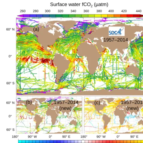
Figure 1.Global distribution of(a)all and(b)newly added surface
waterfCO2values (µatm) and(c)the timing of the newly added
data sets in SOCAT version 3 with data set flags of A to E. Version 3 has data sets from 1957 to 2014.
mosphere Study (SOLAS) Open Science Conference in Kiel, Germany. This manuscript documents SOCAT version 3, while highlighting the key differences with respect to ver-sion 2 (Sect. 2). The SOCAT Fair Data Use Statement is pre-sented in Sect. 3. This is followed by a description of data upload, quality control (Sect. 4) and the data products avail-able for version 3 (Sect. 5). We also look forward towards ongoing developments affecting future SOCAT versions, no-tably automated data upload, inclusion of additional param-eters and annual releases (Sect. 6). The article ends with an assessment of the impact and scientific applications of SO-CAT to date (Sect. 7) and concluding remarks (Sect. 8). This publication will be updated regularly using the format of the ESSD(Earth System Science Data) “living data” to docu-ment the SOCAT versions and significant changes in the data collection, data upload, quality control and data products. This is the first version of the SOCAT “living data” and is closely associated with earlierESSDpublications describing SOCAT versions 1 (Pfeil et al., 2013; Sabine et al., 2013) and 2 (Bakker et al., 2014).
2 Characteristics of SOCAT version 3 and key differences to version 2
Version 3 of the Surface Ocean CO2Atlas includes 14.7
mil-lion surface waterfCO2 values over the time period 1957
Table 1.Key differences between SOCAT versions 2 and 3. See text and Table 2 for further detail and an explanation of cross-overs and
standard operating procedures (SOPs). Calculation of “recommendedfCO2” (fCO2rec) is explained in Sect. 4.2.
Version 2 Version 3
Description Bakker et al. (2014) This study.
Fair Data Use Statement Data policy on web pages. Renamed to Fair Data Use Statement. Phrased more strongly
and given more prominence on the SOCAT web sites.
Data coverage 1968 to 2011, 10.1 million surface waterfCO2
val-ues, 2660 data sets with a WOCE flag of 2.
1957 to 2014, 14.7 million surface waterfCO2values from
3646 data sets (3640 with a WOCE flag of 2 and 6 with a flag of 3).
Time stamp The time stamp includes seconds for all data sets.
When equal time stamps occurred, evenly distributed artificial seconds were added to time stamps.
Artificial seconds were added for concurrent entries. A WOCE flag of 4 was given to duplicate times in data sets with less than 50 equal time stamps (Table 7).
Upload Dashboard Not available. Single platform for data upload,fCO2rec calculation and
au-tomated data checks.
Data upload Bulk data upload on quality control system. All data sets in versions 1, 2 and 3 were uploaded on the
Upload Dashboard.
Calculation offCO2rec In Matlab, prior to bulk data upload. On the Upload Dashboard with Ferret scripts for all data in
versions 1, 2 and 3.
Automated data checks Not available. Automated checks after calculation offCO2rec for all new
and updated data sets. WOCE flags of 4 were assigned in specific cases (Table 7).
Quality Control Editor As in version 1. After automated checks. Upgraded search options and
graph-ical interface. Data set QC flag needs to match QC criteria (tick boxes).
Data set
QC flags in data products
Flags of A–D. Flags of A–E. Revised data set QC criteria (Table 2) applied
to all new and updated data sets.
Flag A Needs a cross-over (an acceptable comparison with
other data).
Needs a high-quality cross-over.
Flags A, B Accuracy equilibrator pressure≤0.5 hPa. Six other
SOP criteria apply.
Accuracy equilibrator pressure≤2 hPa. Six other SOP crite-ria apply.
Flag C Did not follow approved methods or SOP criteria Did or did not follow approved methods or SOP criteria.
Flags C, D AccuracyfCO2rec not specified. AccuracyfCO2rec≤5 µatm.
Flag E Not available. AccuracyfCO2rec≤10 µatm, mainly for alternative sensors
and platforms with in situ calibration and full documentation.
WOCE flags for
fCO2rec
Flag of 2 (good) as a default. Manual entry of flags of 3 (questionable) and 4 (bad).
Flag of 2 as a default. Flags of 4 given during automated data checks (Table 7). Quality control comment added dur-ing manual entry of flags of 3 and 4.
Parameter NCEP (2012) atmospheric pressure, atmospheric CO2
mole fraction from GLOBALVIEW-CO2 (2012).
NCEP (2014) atmospheric pressure, atmospheric CO2mole
fraction from GLOBALVIEW-CO2 (2014).
Synthesis products Data sets with flags of A–D andfCO2rec with a
WOCE flag of 2 in synthesis and gridded files and as default elsewhere.
Data sets with flags of A–E made public (Table 8). Data sets
with flags of A–D andfCO2rec with a WOCE flag of 2 in
synthesis and gridded files. Data sets with a flag of E and
fCO2rec with a flag of 2 in a separate synthesis file. Contents of files downloadable from the Data Set Viewer have been streamlined (Table 9).
Gridded products Missing grid cells in cruise-weighted gridded
prod-ucts (versions 1 and 2). A gridded product of means per climatological month is available.
Correction of data-set-weighted gridded products (version 3). No gridded product of means per climatological month.
Data Set Viewer and
Gridded Data Viewer
On different software platforms. On a single software platform with a powerful graphical
in-terface, following the move of the Data Set Viewer.
Terminology Terms in version 1: cruises, ships, Cruise Data Viewer,
Table of Cruises, cruise-weighted means.
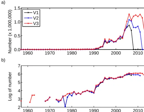
1960 1970 1980 1990 2000 2010 0.0
0.5 1.0 1.5
Number (x 1,000,000)
a)
V1 V2 V3
1960 1970 1980 1990 2000 2010
2 3 4 5 6 7
Year
Log of number
b)
Figure 2.(a)Number of surface waterfCO2values per year and
(b)the base 10 logarithm of this number per year for 1957 to 2014
in SOCAT versions 1, 2 and 3 (after Bakker et al., 2014).
data sets, collected on ships (3504 cruises), moorings (123) and drifters (19). The 3646 data sets include 3640 data sets with a WOCE (World Ocean Circulation Experiment) flag of 2 (good), available in all data products, as well as six data sets with a WOCE flag of 3 (questionable), only available in some data products, if selected. Version 3 is an update of ver-sion 2 with an additional 4.6 millionfCO2values from 986
data sets. Version 3 takes the start of the data record back-wards from 1968 to 1957 by adding four historic cruises. It also extends the data collection forward by adding 1.8 mil-lionfCO2values for 2012 and 2013, as well as a small
num-ber of values from 2014 (Fig. 2). Version 3 also increases the number of fCO2 values for many years between 1989
and 2011. It adds 50 % morefCO2values for 2008 to 2010,
while doubling the available data for 2011. The year 2006 has the largest number offCO2values, closely followed by
2009 and 2011.
New in version 3 is an accuracy criterion for all surface ocean fCO2 values, described by data set quality control
(QC) flags of A to E, for accuracies of 2 (A, B), 5 (C, D) and 10 µatm (E) (Table 2) (Sect. 4.4) (Wanninkhof et al., 2013b; Olsen et al., 2015). Flag A now also requires a high-quality cross-over with another data set. The introduction of a lower-accuracy, data set quality control flag of E (accuracy of fCO2 values better than 10 µatm) enables the inclusion
of calibratedfCO2measurements made by alternative
sen-sors and on alternative platforms (Wanninkhof et al., 2013b; Olsen et al., 2015). Version 3 has significantly more data sets from fixed moorings (123 data sets) and drifting buoys (19) than version 2 (28 and 3 data sets, respectively). These measurements were made by an equilibrator system with in-frared detection (e.g. Johengen, 2010; Sutton et al., 2014b)
or a membrane spectrophotometer (e.g. Boutin and Merlivat, 2009; Merlivat et al., 2015).
Overall, the quality of the data is comparable to that of ver-sion 2, with a small improvement in the documentation of the individual data sets. In version 3, 14 % of the data sets (509 data sets) received a quality control flag of A, 35 % (1260 data sets) a flag of B, 23 % (840) a flag of C and 27 % (990) a flag of D. This compares to 17 % (454 data sets), 31 % (834), 18 % (491) and 33 % (881), respectively, in version 2. The percentage of data sets receiving a flag of A or B is remarkably similar between both versions (49 % in version 3, 48 % in version 2). The small reduction in the percent-age of data sets with a flag of D (27 % in version 3, 33 % in version 2), which implies incomplete metadata, highlights an improvement in the documentation accompanying indi-vidual data sets. A total of 41 data sets (1 %) received a flag of E; most of these are sensor data, but they also include a small number of valuable historic data sets with an accuracy deemed better than 10 µatm.
Version 3 represents a major step towards the automation of the SOCAT data and metadata upload and quality con-trol in future versions. A new interface, the SOCAT Upload Dashboard, hosts data and metadata upload, (re)calculation offCO2, automated data checks, data visualisation and
sub-mission to the quality control system in a single applica-tion (Table 1). A prototype of the SOCAT Upload Dash-board was used for data upload for version 3 (Sect. 4.1) and (re)calculation offCO2 (Sect. 4.2). All data sets were run
across a newly developed, automated data checker for iden-tification of values that were out of range (Sect. 4.3). As a result, issues identified during data upload were already cor-rected prior to entry on the quality control system. The search capabilities and graphical interface of the quality control sys-tem and the associated Data Set Viewer (previously known as the Cruise Data Viewer) were upgraded (Sects. 4.4 and 5.4). Version 4 will see enhanced implementation of SOCAT au-tomation by enabling data providers to upload their data us-ing the SOCAT Upload Dashboard and submission onto the SOCAT QC Editor (Sect. 6.1).
The publicly accessible, user-friendly and interactive Data Set Viewer now allows selection offCO2values by data set,
year, month, region, data provider, vessel or platform name, country of the vessel’s or platform’s flag, data set quality con-trol flag, WOCE flag and SOCAT version, as well as setting of limits on data ranges. The graphical tools of the Data Set Viewer (access via http://www.socat.info/) for SOCAT ver-sion 3 have been extended (Figs. 1, 3 and 4). Users can now set fixed colour scales and create high-quality, publishable images.
A small error was detected in the gridded data products of SOCAT versions 1 and 2 (Sect. 5.5). In short, the data-set-weightedfCO2values (formerly known as cruise-weighted
fCO2values) in these products were found to have missing
Table 2.Data set quality control (QC) flags in version 3 (Wanninkhof et al., 2013b; Olsen et al., 2015). All criteria need to be met for assigning a flag of A to E. Data sets with flags of A to E have been made public. Data sets with a flag of A to D are included in the global synthesis and gridded products (Table 8). Changes relative to versions 1 and 2 are in bold. Flag (ID) refers to the data set quality control flag
with its numerical identifier (ID) provided between brackets. Calculation of “recommendedfCO2” (fCO2rec) is explained in Sect. 4.2.
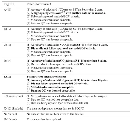
Flag (ID) Criteria for version 3
A (11) (1) Accuracy of calculatedfCO2rec (at SST) is better than 2 µatm.
(2) A high-quality cross-over1,2with another data set is available.
(3) Followed approved methods/SOP3criteria.
(4) Metadata documentation complete. (5) Data set QC was deemed acceptable.
B (12) (1) Accuracy of calculatedfCO2rec (at SST) is better than 2 µatm.
(2) Followed approved methods/SOP criteria. (3) Metadata documentation complete. (4) Data set QC was deemed acceptable.
C (13) (1) Accuracy of calculatedfCO2rec (at SST) is better than 5µatm.
(2) Did or did not follow approved methods/SOP criteria.
(3) Metadata documentation complete. (4) Data set QC was deemed acceptable.
D (14) (1) Accuracy of calculatedfCO2rec (at SST) is better than 5µatm.
(2) Did or did not follow approved methods/SOP criteria. (3) Metadata documentation incomplete.
(4) Data set QC was deemed acceptable.
E (17) Primarily for alternative sensors
(1) Accuracy of calculatedfCO2rec (at SST) is better than 10µatm. (2) Did not follow approved methods/SOP criteria.
(3) Metadata documentation complete. (4) Data set QC was deemed acceptable.
S (15) (Suspend) (1) More information is needed for data set before flag can be assigned.
(2) Data set QC revealed non-acceptable data. (3) Data are being updated (part or the entire data set).
X (15) (Exclude) The data set duplicates another data set in SOCAT.
N (No flag) No data set flag has yet been given to this data set.
U (Update) The data set has been updated.
No data set flag has yet been given to the revised data.
1A cross-over between two data sets is defined as an equivalent distance of less than 80 (Pfeil et al., 2013). This criterion combines distance and
time as ([1x2+(1t×30)2]0.5)≤80 with distancexin kilometres and timetin hours. One day of separation in time is equivalent (heuristically) to 30 km of separation in space.2A high-quality cross-over is defined as a cross-over between two data sets with a maximum cross-over equivalent
distance of 80 km, a maximum difference in sea surface temperature of 0.3◦C and a maximumfCO2rec difference of 5 µatm. Inconclusive
cross-overs with the temperature orfCO2rec difference between the data sets exceeding 0.3◦C or 5 µatm, respectively, do not receive a flag of A.
High-quality cross-overs are rare in coastal waters, near sea ice and in regions of freshwater influence, as a result of high spatial variation, not for lack of measurement quality (Sect. 4.4).3Seven approved methods or SOP (standard operating procedure) criteria need to be fulfilled for a data set
quality control flag of A and B (Sect. 4.4) (after Pfeil et al., 2013). In version 3, the accuracy requirement for equilibrator pressure has been relaxed to 2.0 hPa from 0.5 hPa in earlier SOCAT versions. The six other criteria are the same in SOCAT versions 1, 2 and 3.
weighted and unweighted gridded products. This was both in time and in position. This error was corrected in the grid-ded data products for version 3. Note that this error remains present in the gridded products for versions 1 and 2.
In summary, SOCAT version 3 is a significant update of version 2. It provides a 58-year record (1957–2014) of 14.7 million surface ocean fCO2 values for the global
oceans and coastal seas. It has higher-quality data with better documentation than version 2. Addition of a flag of E has
en-abled inclusion of calibratedfCO2 values from alternative
sensors and platforms. All surface oceanfCO2values now
Surface water fCO2(µatm)
260 280 300 320 340 360 380 400 420 440
JAS 2000s 60°N
0°
60°S
60°N
0°
60°S
60°N
0°
60°S
180° 90°W 0° 90°E 180° 90°W 0° 90°E 180° 1957-69
c)
2000s
1970s
1980s 1990s
2010-14 d)
f) e)
a) b)
Figure 3.Decadal distribution of surface waterfCO2(µatm) for
the global oceans and coastal seas in SOCAT version 3:(a)1957
through 1969, (b) 1970s, (c) 1980s, (d) 1990s, (e) 2000s, and
(f)2010 through 2014. Similar figures are available for versions 1
and 2 (Pfeil et al., 2013; Brévière et al., 2015).
3 Fair Data Use Statement for SOCAT version 3
The Surface Ocean CO2 Atlas provides access to a vast
amount of surface ocean CO2 data from the global oceans
and coastal seas, painstakingly collected by marine carbon scientists around the world over 58 years. These data sets rep-resent an important scientific output by these scientists. Indi-vidual researchers and the marine carbon community make these data public in SOCAT, such that they are available for scientific research and for informing policy (Sects. 7 and 8). Nonetheless, it is important that the data providers receive credit for the data that they collected. This will provide data providers with vital evidence of how their data are being used, enabling successful funding applications for future data collection.
Furthermore, the assembly, quality control and archiving of SOCAT data products involve many data managers and scientists (Tables 3 and 4). Planning meetings and commu-nity events have proved effective in informing SOCAT con-tributors and users, in discussing SOCAT progress and in set-ting SOCAT strategy (Table 5).
The SOCAT Fair Data Use Statement therefore contains an urgent request to generously acknowledge the contribu-tion by SOCAT data contributors and investigators. Ideally users will invite large data providers to contribute to regional studies and, if they do, to co-author relevant papers. Citation of relevant scientific articles by data providers is a good sci-entific practice. The following Fair Data Use Statement
ap-Surface water fCO2(µatm)
260 280 300 320 340 360 380 400 420 440
60°N
0°
60°S
60°N
0°
60°S
180° 90°W 0° 90°E 180° 90°W 0° 90°E 180° JFM
2000s
c)
AMJ 2000s
JAS 2000s
OND 2000s d)
a) b)
Figure 4.Seasonal distribution of surface waterfCO2(µatm) for
the months(a) January through March, (b) April through June,
(c)July through September and(d)October through December in
the years 2000 through 2009 in SOCAT version 3 for data sets with flags of A to E (after Bakker et al., 2014).
plies to SOCAT data products (SOCAT, 2016): the synthesis and gridded SOCAT products are a result of scientific effort by data providers, data managers and quality controllers. It is important that users of the SOCAT products fairly acknowl-edge this effort. This will help generate funding for continu-ation of observcontinu-ational products and promote further sharing of data.
We expect the following from users of SOCAT data prod-ucts:
1. To generously acknowledge the contribution of SOCAT data providers and investigators in the form of invita-tion to co-authorship, reference to relevant scientific ar-ticles by data providers or by naming the data providers in the acknowledgements. Specifically, in regional stud-ies, users should invite large data providers, who fre-quently possess valuable expert knowledge on data and region, to collaborate at an early stage, which may lead to an invitation of authorship. We recognise that co-authorship is only justified in the case of a significant scientific contribution to a publication and that provi-sion of data on its own does not warrant co-authorship.
2. To cite SOCAT and its data products as follows:
version 3: this study;
version 2: Bakker et al. (2014);
version 1 (synthesis data products): Pfeil et al. (2013);
version 1 (gridded data products): Sabine et al. (2013) and Pfeil et al. (2013).
3. To include the following text in the acknowledge-ments: “The Surface Ocean CO2 Atlas (SOCAT) is
Table 3.Activities and participants in SOCAT version 3 and the automation (after Bakker et al., 2014). Regional group leads are in Table 4.
Activity Participants
Global group Bakker (chair), Currie, Kozyr, Metzl, O’Brien, Olsen, Pfeil, Pierrot, Telszewski
Data retrieval, upload,fCO2calculation Landa, Pfeil, Olsen, Smith
Live Access Server for data upload, quality control and data viewers
Smith, O’Brien, Manke, Hankin, Schweitzer
Inclusion of sensors Wanninkhof, Steinhoff, Bakker, Bates, Boutin, Olsen, Sutton
Automation (version 3) O’Brien, Smith, S. D. Jones, Landa, Manke, Olsen, Pfeil, Schweitzer, Bakker
Automation (metadata, version 4) As automation for version 3, plus Shrestha, Ranjeet
Quality control Alin, Bakker, Barbero, Bonou, Castle, Cosca, Currie, Evans, Featherstone,
Green-wood, Harasawa, Hauck, Humphreys, Hunt, Ibánhez, Lefèvre, Metzl, Nakaoka, Pa-terson, Schuster, Skjelvan, Steinhoff, Sullivan, Sutton, Tilbrook, Wada
Data products, archiving Pfeil, Smith, Kozyr, Manke, O’Brien, Schlitzer, Sieger
Matlab code for reading products Pierrot, Landschützer
Website Pfeil, Bakker, Landa, Metzl
Meetings Bakker, Cosca, O’Brien, Steinhoff, Telszewski
Table 4.Regions with their leads in version 3 (after Bakker et al., 2014). The regions are the same as in version 2.
Region Definition Lead(s)
Coastal and marginal seas <400 km from land;
70◦N to 30◦S for 100◦W to 43◦E;
66◦N to 30◦S elsewhere
Alin
Arctic Ocean North of 70◦N for 100◦W to 43◦E;
north of 66◦N elsewhere, incl. coastal waters
Mathis
North Atlantic 70 to 30◦N Schuster
North Pacific 66 to 30◦N Nojiri
Tropical Atlantic 30◦N to 30◦S Lefèvre
Tropical Pacific 30◦N to 30◦S Cosca
Indian Ocean North of 30◦S Sarma
Southern Ocean South of 30◦S, incl. coastal waters Tilbrook, Metzl
Ocean Carbon Coordination Project (IOCCP), the Sur-face Ocean Lower Atmosphere Study (SOLAS), and the Integrated Marine Biogeochemistry and Ecosystem Research program (IMBER), to deliver a uniformly quality-controlled surface ocean CO2 database. The
many researchers and funding agencies responsible for the collection of data and quality control are thanked for their contributions to SOCAT.”
4. To report problems to [email protected].
5. To inform [email protected] of publications in which SOCAT is used.
The Fair Data Use Statement (SOCAT, 2016) replaces the earlier “SOCAT Data Policy” (SOCAT, 2013a; Bakker et al., 2014). The text has been phrased more strongly and examples of the application of the Fair Data Use Statement have been added. The Fair Data Use Statement is available in full on the SOCAT web pages (e.g. http://www.socat.info/SOCAT_fair_ data_use_statement.htm). The revision follows con-cerns raised by SOCAT data providers and
discus-sions among SOCAT scientists at two recent community events (SOCAT, 2014a; SOCAT and SOCOM, 2015).
4 Data assembly and quality control in version 3
4.1 Data retrieval and data upload on the SOCAT Upload Dashboard
Table 5.Meetings for SOCAT version 3 and the ongoing SOCAT automation. The meeting reports are available on the SOCAT website (http://www.socat.info/meetings.html).
Timing Meeting Location Reference
May 2012 Automation planning meeting NOAA-PMEL, Seattle, USA SOCAT (2012a)
July 2012 Progress meeting Epochal Centre, Tsukuba, Japan SOCAT (2012b)
June 2013 SOCAT side event, release of version 2 9th International Carbon Dioxide Conference,
Beijing, China
SOCAT (2013b)
June 2014 Community event IMBER Open Science Conference, Bergen,
Norway
SOCAT (2014a)
October 2014 Automation meeting NOAA-PMEL, Seattle, USA SOCAT (2014b)
September 2015 SOCAT and SOCOM event, release of version
3, launch of automation system, SOCOM science.
SOLAS Open Science Conference, Kiel, Germany
SOCAT and SOCOM (2015)
As in previous versions, all new and updated data sets were put in a uniform format (Pfeil et al., 2013). Similar to ver-sion 2, an expocode was assigned to all data sets, including moorings and drifters (Bakker et al., 2014). In general, an ex-pocode consists of 12 characters, describing the country, the vessel or platform, and the data set start day (Swift, 2008). The expocode 320620090306, for example, indicates a data set collected on the US (32) ship R/VNathaniel B. Palmer (06) with the first day of the cruise on 6 March 2009. There are a few exceptions to this. If two American mooring data sets (which always start with 3164) have the same start date, they will end with “−1” and “−2”, corresponding to an ex-pocode of 14 characters.
In version 3, the SOCAT data managers used the new SO-CAT Upload Dashboard for upload of data and metadata (Ta-ble 1). All data sets previously included in versions 1 and 2 were also uploaded, automatically screened for obvious out-liers and added to version 3 via the SOCAT Upload Dash-board (Table 1). This new capability is an important step in the ongoing SOCAT automation effort and integrates data and metadata upload, (re)calculation of fCO2, automated
data checks, data visualisation and data submission in a sin-gle application which is tightly coupled to the SOCAT QC Editor. Once fully operational in version 4, the Upload Dash-board will allow data providers to upload, verify and submit their data for SOCAT quality control.
Not all data sets had time stamps which included sec-onds. In such cases, multiple occurrences of a time stamp were often present. Artificial seconds were added to data sets with 50 or more duplicate time stamps. For these data sets, evenly distributed artificial seconds were added for each equal time stamp. However, if there were less than 50 dupli-cate times in a data set, a WOCE flag of 4 was generated for the fCO2rec values (or “recommended” fCO2 values;
see Sect. 4.2) with duplicate time stamps during the auto-mated data checks (Sect. 4.3). Adding artificial seconds is time-consuming and there was insufficient time available for adding artificial seconds to all duplicate times in all data sets.
4.2 (Re)calculation offCO2
Data providers reported CO2values asxCO2,pCO2and/or
fCO2, at the equilibration temperature (Tequ) and/or the sea
surface temperature (SST or intake temperature). In order to ensure a coherent SOCAT synthesis product, surface water fCO2 values at sea surface temperature were recalculated
from the reported CO2values using a strict calculation
proto-col with the following procedure (quoting Pfeil et al., 2013):
1. when possible, (re)calculatefCO2;
2. the preferred starting point for the calculations isxCO2, thenpCO2, and finallyfCO2;
3. minimise the use of external data required to complete the calculations.
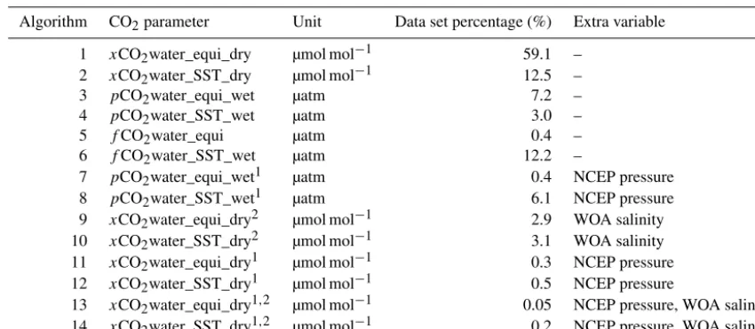
In total, 14 algorithms were used for (re)calculating these “recommended”fCO2 (fCO2rec) values from the xCO2,
pCO2 and/or fCO2 values reported by the data providers
(Table 6). The particular algorithm used for a given data set is included in the data products (Sect. 5). Equations recom-mended by Dickson et al. (2007) were applied for the con-version of the dry CO2mole fraction topCO2, for the
calcu-lation of the water vapour pressure and for the correction of pCO2tofCO2(Pfeil et al., 2013). The temperature
Table 6.Algorithms and surface water CO2parameters used in the calculation of recommendedfCO2(fCO2rec) at sea surface temperature in version 3 (after Pfeil et al., 2013). Algorithm 1 was the preferred method, followed by algorithm 2 and so forth. The algorithm used for each data set is stated in the output files (Table 9). In the case of incomplete reporting, NCEP (National Centers for Environmental Prediction) atmospheric pressure (Kalnay et al., 1996; NCEP, 2014) and WOA (World Ocean Atlas) 2005 salinity (Antonov et al., 2006) were applied.
Algorithm CO2parameter Unit Data set percentage (%) Extra variable
1 xCO2water_equi_dry µmol mol−1 59.1 –
2 xCO2water_SST_dry µmol mol−1 12.5 –
3 pCO2water_equi_wet µatm 7.2 –
4 pCO2water_SST_wet µatm 3.0 –
5 fCO2water_equi µatm 0.4 –
6 fCO2water_SST_wet µatm 12.2 –
7 pCO2water_equi_wet1 µatm 0.4 NCEP pressure
8 pCO2water_SST_wet1 µatm 6.1 NCEP pressure
9 xCO2water_equi_dry2 µmol mol−1 2.9 WOA salinity
10 xCO2water_SST_dry2 µmol mol−1 3.1 WOA salinity
11 xCO2water_equi_dry1 µmol mol−1 0.3 NCEP pressure
12 xCO2water_SST_dry1 µmol mol−1 0.5 NCEP pressure
13 xCO2water_equi_dry1,2 µmol mol−1 0.05 NCEP pressure, WOA salinity
14 xCO2water_SST_dry1,2 µmol mol−1 0.2 NCEP pressure, WOA salinity
1Atmospheric pressure was not reported in the original data file.2Salinity was not reported in the original data file.
An important change relative to earlier versions is that the (re)calculation in version 3 took place using Ferret scripts on the new SOCAT Upload Dashboard after data upload (Sect. 4.1), rather than in Matlab before the bulk upload of the data (Table 1). The implementation of the Ferret scripts enables full integration of SOCAT data submission, (re)calculation offCO2and quality control on a single
soft-ware platform. This streamlines and simplifies the SOCAT data flow. The Matlab code used for the (re)calculation in versions 1 and 2 was transferred to Ferret scripts on the Up-load Dashboard for version 3. The new Ferret scripts were checked by comparingfCO2rec values in version 2
calcu-lated using Matlab and new values calcucalcu-lated using Ferret. Almost all new values were within 0.01 µatm of the value calculated in Matlab, if not identical to it. Significant changes (smaller than 5 µatm) for less than 200 data points were at-tributed to changes in atmospheric pressure from reanalysis (Table 1).
4.3 Automated data checks
A newly developed, automated data checker performed checks on parameters directly influencing the position, time or calculation offCO2rec values (Tables 1 and 7). A WOCE
flag of 4 (meaning a bad data point) was assigned to all fCO2rec values with an incorrect position or time stamp or
otherwise identified as inaccurate. These automated checks were carried out on all data in version 3 after (re)calculation offCO2rec and before submission to the quality control
sys-tem.
Unintentionally, WOCE flags of 4 were also assigned for values which were out of range in parameters which do not
directly affectfCO2rec values, such as wind speed and ship
direction (Table 7). This resulted in a WOCE flag of 4 being given to some good-qualityfCO2rec values in newly added
and updated data sets in version 3. The criteria for the auto-mated checks will be reconsidered for version 4.
Automated data checks were also performed for data sets previously included in versions 1 and 2 (and not updated in version 3). For these data sets all WOCE flags of 4 assigned by the automated data checker, other than for duplicate time stamps, were removed to preserve the data sets as reported for version 2.
4.4 Secondary quality control
Secondary quality control is a key part of the creation of a high-quality data synthesis product. During secondary qual-ity control, scientists, also known as qualqual-ity controllers, as-sess the quality of each new and updated data set by follow-ing a checklist of specific criteria, while also examinfollow-ing the documentation of the data, known as metadata, for complete-ness. The quality controllers assign a data set quality control flag to each data set, based on their findings (Table 2).
Table 7.Criteria for the automated data checks and the action taken in version 3. In the case of duplicate time stamps, artificial seconds were generated. If there were less than 50 duplicate times in the data set, a WOCE flag of 4 was given. For other parameters, a flag of 4 was
automatically assigned to thefCO2rec value if their values were outside a specified range. Criteria not directly affectingfCO2rec values
will be revised for version 4 (Sect. 4.3).
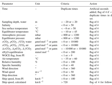
Parameter Unit Criteria Action
Time – Duplicate times Artificial seconds
added; flag of 4 if<50 duplicate times in data set.
Sampling depth, water m <−20 or>20 flag of 4
Salinity – <0 or>50 flag of 4
Sea surface temperature ◦C <−8 or>50 flag of 4
Equilibrator temperature ◦C <−10 or>45 flag of 4
Atmospheric pressure mbar <800 or>1200 flag of 4
Equilibrator pressure mbar <800 or>1200 flag of 4
xCO2,pCO2,fCO2water µmol mol−1or µatm <0 or>10 000 flag of 4
xCO2,pCO2,fCO2air µmol mol−1or µatm <0 or>10 000 flag of 4
1xCO2,1pCO2,1fCO2 µmol mol−1or µatm <−10 000 or>10 000 flag of 4
xH2O equilibration mmol mol−1 <0 or>200 flag of 4
WOCE flag, from PI – <1 or>9 flag of 4
Air temperature ◦C <−35 or>60 flag of 4
Relative humidity % <0 or>100 flag of 4
Specific humidity – <0 or>40 flag of 4
Wind direction ◦ <0 or>360 flag of 4
Wind speed m s−1 <0 or>50 flag of 4
Ship direction ◦ <0 or>360 flag of 4
Ship speed, from PI km h−1 <0 or>100 flag of 4
Ship speed, calculated km h−1 >720 flag of 4 for following
point
The definitions of the data set quality control flags in ver-sion 3 have been revised relative to verver-sions 1 and 2 (Tables 1 and 2) (Wanninkhof et al., 2013b; Olsen et al., 2015). These revised QC criteria were applied to all new and updated data sets in version 3, but not retrospectively to data sets included in earlier versions, unless data providers had updated these. Version 3 has data set quality control flags of A to E and WOCE flags of 2, 3 and 4 for individual fCO2rec values.
For a data set to obtain a data set quality control flag, it needs to meet all the criteria of that specific data set flag (Table 2). All data set flags now have an accuracy requirement for the fCO2rec values. Previously, flags of C and D did not
have an accuracy requirement (Pfeil et al., 2013; Bakker et al., 2014). In version 3, requirements are an accuracy of bet-ter than 2 µatm for flags of A and B, and of betbet-ter than 5 µatm for flags of C and D and of better than 10 µatm for a flag of E (Table 2). The accuracy requirement takes precedent over the criteria that follow (Wanninkhof et al., 2013b; Olsen et al., 2015), implying that, if the accuracy requirement is not met, a data set is given a data set flag with a lower accuracy requirement, appropriate to the accuracy of the data set.
Seven approved methods or SOP (standard operating pro-cedure) criteria need to be met for a data set quality control flag of A and B (after Pfeil et al., 2013):
1. The data are based onxCO2analysis, notfCO2
calcu-lated from the other carbon parameters pH, total alka-linity and dissolved inorganic carbon.
2. Continuous CO2 measurements have been made, not
discrete CO2measurements.
3. The CO2detection is based on an equilibrator system
and is performed by infrared analysis or gas chromatog-raphy.
4. The calibration has included at least two non-zero gas standards, traceable to World Meteorological Organiza-tion (WMO) standards.
5. The equilibrator temperature has been measured to within 0.05◦C accuracy.
6. The intake seawater temperature has been measured to within 0.05◦C accuracy.
7. The equilibrator pressure has been measured to within 2.0 hPa accuracy.
3, replacing the earlier requirement of 0.5 hPa, as an accuracy of 2.0 hPa in pressure is sufficient for achieving an accuracy of 2.0 µatm in fCO2 (Wanninkhof et al., 2013b; Olsen et
al., 2015). The six other criteria are the same in all SOCAT versions.
In version 3, a high-quality cross-over has become a prequisite for a data set flag of A, replacing the earlier re-quirement of “an acceptable comparison (or cross-over) with other data” (Wanninkhof et al., 2013b; Olsen et al., 2015). As in previous versions, a cross-over is defined by an equiv-alent distance of less than 80 km between two data sets (Pfeil et al., 2013). This criterion combines distance and time as ([1x2+ (1t×30)2]0.5)≤80 with distance x in kilometres and timet in days. One day (or 24 h) of separation in time is equivalent (heuristically) to 30 km of separation in space. According to this definition, the maximum time separation (at a spatial distance of 0 km) is 64 h for a cross-over to oc-cur. The new definition of a high-quality cross-over between two data sets requires that differences in sea surface tempera-ture andfCO2rec between the data sets do not exceed 0.3◦C
and 5 µatm, respectively. These criteria reflect the test for a high-quality cross-over between two data sets with a flag of A or B, i.e. each with an accuracy forfCO2rec of better than
2 µatm or a joint accuracy of better than 4 µatm with 1 µatm added to account for differences in time and space. A temper-ature difference of 0.3◦C roughly corresponds to anfCO2
difference of 5 µatm. “Inconclusive” cross-overs, where dif-ferences in temperature orfCO2rec exceed these values, do
not qualify for a data set flag of A in version 3.
It is worth noting that meaningful high-quality cross-overs are rarely found in coastal waters, near sea ice and in regions of freshwater influence (ROFIs), as a result of high spatial variation in sea surface temperature and fCO2rec, not for
lack of measurement quality. Even if a small number of sea surface temperature and fCO2rec values are within 0.3◦C
and 5 µatm, this tends to be a coincidence rather than a mean-ingful correspondence between data sets. This can be illus-trated for the US research shipsNathaniel B. Palmerand the Lawrence M. Gould, which have frequent high-quality overs in the open Southern Ocean but few high-quality cross-overs near Palmer station, where they both make port calls.
In version 3, a data set with a flag of C “did or did not follow approved methods or SOP criteria” (Wanninkhof et al., 2013b; Olsen et al., 2015). This is an amendment from the earlier requirement that the data set “did not follow ap-proved methods or SOP criteria” (Pfeil et al., 2013; Bakker et al., 2014). The new flag of E enables inclusion offCO2
val-ues from calibrated alternative sensors and platforms (Wan-ninkhof et al., 2013b; Olsen et al., 2015). A flag of E re-quires complete metadata and a demonstrable accuracy for fCO2rec of better than 10 µatm by in situ calibration of the
sensor. The WOCE flags for individualfCO2rec values are
defined as 2 (good), 3 (questionable) and 4 (bad) in versions 1, 2 and 3 (Pfeil et al., 2013). New is the requirement to add a comment when assigning WOCE flags of 3 and 4 (Table 1).
As in version 2, five additional guidelines were consid-ered for open-oceanfCO2rec values, away from sea ice. The
guidelines were used for assigning data set quality control flags and WOCE flags (after Pfeil et al., 2013, and Bakker et al., 2014):
1. warming between the seawater intake and the equilibra-tor should be less than 3◦C;
2. warming rate should be less than 1◦C h−1, unless a sharp temperature front is apparent;
3. warming outliers should be less than 0.3◦C, compared to background data;
4. cooling between the seawater intake and the equilibra-tor is unlikely in high-latitude oceans for an indoor mea-surement system;
5. zero or constant temperature difference between the equilibrator and seawater intake usually indicates the absence of SST values.
As for SOCAT version 2, quality controllers were organised into eight regions, each with a group lead (Table 4). The eight regions included the coastal and marginal seas, the Arctic Ocean, the North and tropical Atlantic, the North and tropi-cal Pacific, the Indian Ocean, and the Southern Ocean. The quality controllers gave data sets a quality control flag for each region they crossed. As a final step, the data set quality control flags for the different regions had to be reconciled.
5 Data products in version 3
5.1 Overview of data products
In essence, the data products and data platforms are the same as for earlier SOCAT versions with some modifications (Ta-ble 8). Improvements include a major upgrade of the search and visualisation capabilities of the Data Set Viewer (previ-ously known as the Cruise Data Viewer) and uniform con-tents for the files downloadable from the Data Set Viewer (Tables 1 and 9). Access to the data products is via the SO-CAT website (http://www.socat.info/) and the web addresses for the individual data platforms (Table 8).
Quality-controlled recommended surface ocean fCO2
measurements in a uniform format are available in individ-ual data set files, in regional and global synthesis files and in gridded form (Table 8). These three data products can be accessed via the user-friendly, interactive online Data Set Viewer and Gridded Data Viewer, by downloading data files, or in Ocean Data View (Schlitzer, 2015). Similar to earlier versions, data sets with a quality control flag of A to D and recommendedfCO2values with a WOCE flag of 2 (good)
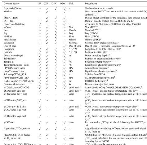
Table 9.Content of the individual data set files (IF) and the synthesis files in SOCAT version 3 (after Bakker et al., 2014). The global synthesis product is available as zip text files (ZIP) at CDIAC and in Ocean Data View (ODV) format (Table 8). Subsets of the global synthesis data set can be created via the Data Set Viewer (DSV), both in the main menu and via the Table of Datasets. The first column lists column headers for the parameters in the files.
Column header IF ZIP DSV ODV Unit Description
Expocode/Cruise – √ √ √ – Twelve-character expocode
Version – √ – √ – Most recent SOCAT version in which data set was added (N) or
updated (U)
SOCAT_DOI – √ √ √ – Digital object identifier for the individual data set and metadata
QC_Flag – √ √ √ – Data set quality control flags A, B, C, D and E
Date/Time/Datetime √ – √ √ – yyyy-mm-dd / hh:mm:ss (ISO8859 and other formats)
yr/Year – √ √ – Year Year (UTC)*
mon – √ √ – Month Month (UTC)*
day – √ √ – Day Day (UTC)*
hh/Hour – √ √ – Hour Hour (UTC)*
mm/Minute – √ √ – Minute Minute (UTC)*
ss/Second – √ √ – Seconds Seconds (may include decimals)*
Day of Year – – – √ Day of year Day of year (UTC) with 1 January, 00:00, as 1.0.
Longitude √ √ √ √ ◦E,◦W Longitude (0 to 360/−180 to 180)*
Latitude √ √ √ √ ◦N,◦S Latitude (−90 to 90)*
Depth water/Depth √ √ √ √ m Water sampling depth*1
Sal/Salinity √ √ √ √ – Salinity on practical salinity scale*
Temp/SST √ √ √ √ ◦C Sea surface temperature*
Tequ/Temperature_Equi √ √ √ √ ◦C Equilibrator chamber temperature*
PPPP/Pressure_Atm √ √ √ √ hPa Atmospheric pressure*
Pequ/Pressure_Equi √ √ √ √ hPa Equilibrator chamber pressure*
Sal interp/WOA_SSS √ √ √ √ – Salinity from WOA2
PPPP interp/NCEP_SLP √ √ √ √ hPa NCEP atmospheric pressure3
Bathy_depth/ETOPO2_depth √ √ √ √ m ETOPO2 bathymetry4
Distance/dist-to-land √ √ √ √ km Distance to major land mass
xCO2air_interp/GVCO2 √ √ √ √ µmol mol−1 AtmosphericxCO2from GLOBALVIEW-CO2 (2014)5
xCO2water_equ_dry √ – – – µmol mol−1 xCO2(water) at equilibrator temperature (dry air)*
fCO2water_SST_wet √ – – – µatm fCO2(water) at sea surface temperature (air at 100 %
humid-ity)*
pCO2water_SST_wet √ – – – µatm pCO2(water) at sea surface temperature (air at 100 %
humid-ity)*
xCO2water_SST_dry √ – – – µmol mol−1 xCO2(water) at sea surface temperature (dry air)*
fCO2water_equ_wet √ – – – µatm fCO2(water) at equilibrator temperature (air at 100 %
humid-ity)*
pCO2water_equ_wet √ – – – µatm pCO2(water) at equilibrator temperature (air at 100 %
humid-ity)*
fCO2rec √ √ √ √ µatm RecommendedfCO2calculated following the SOCAT
proto-col
Algorithm/fCO2_source √ √ √ √ – Algorithm for calculatingfCO2rec (0: not generated; algorithm
1–14, Table 6)
Flag/WOCE_CO2_Water √ √ √ – – WOCE flag forfCO2rec (2: good; 3: questionable; 4: bad)6
fCO2in wet air – – –
√
µatm fCO2(air) calculated for sea surface temperature and 100 %
humidity from GVCO2
Ocean – AirfCO2Difference – – –
√
µatm fCO2difference between water and air
Vessel – – – √ – Name of vessel or platform
√
Available. * If reported by the data originator.1If the intake depth has not been reported by the data originator, an intake depth of 5 m has been assumed.2Sea surface salinity on the practical salinity scale extracted from the World Ocean Atlas (WOA) 2005 (Antonov et al., 2006), available at http://www.nodc.noaa.gov/OC5/WOA05/woa05nc.html, using the data set s0112an1.nc from the “monthly” link at http://data.nodc.noaa.gov/opendap/woa/WOA05nc/ (last access: 1 September 2015). This data set is identical to that SOCAT version 2. 3Atmospheric pressure extracted from the NCEP/NCAR (National Centers for Environmental Prediction/National Center for Atmospheric Research) 40-Year Reanalysis Project on a 6-hourly, global, 2.5◦latitude by 2.5◦longitude grid (Kalnay et al., 1996; NCEP, 2014). This is an update relative to the 2012 data set (NCEP, 2012) used in SOCAT version 2.
4Bathymetry extracted from ETOPO2 (2006) 2 min Gridded Global Relief Data. This data set is identical to that in SOCAT version 2.5GLOBALVIEW-CO2 (2014), downloading the “surface” reference type gives the sine function of latitude versus time for the reference marine boundary layer. This is an update relative to the 2012 version used in SOCAT version 2. 6Individual data set files contain allfCO
Table 10.Gridded products and parameters reported for each grid cell in SOCAT version 3 (after Sabine et al., 2013). Version 3 does not have a monthly climatology.
Parameter Unit Decadal Annual Monthly Monthly 1/4◦×1/4◦
mean mean mean coastal
Number of data sets – √ √ √ √
Number of observations – √ √ √ √
fCO2unweighted mean µatm
√ √ √ √
fCO2data-set-weighted mean µatm
√ √ √ √
fCO2max µatm
√ √ √ √
fCO2min µatm
√ √ √ √
fCO2SD unweighted µatm – –
√ √
fCO2SD weighted µatm – – √ √
Latitudinal average offset from cell centre ◦N – – √ √
Longitudinal average offset from cell centre ◦E – – √ √
fCO2values is the default setting for the Data Set Viewer.
Quality control comments can be accessed via the Data Set Viewer (Table 8). While the SOCAT data products include seawater temperature and salinity, as these are required for (re)calculation offCO2, these two parameters have not been
quality-controlled to the high standards required by the phys-ical oceanographic community (SOCAT, 2014a).
As in earlier versions, each individual data set has a dig-ital object identifier (DOI), which provides a direct link to the metadata, including the name and affiliation of the data provider. This DOI for the data set is available for each rec-ommended surface oceanfCO2value in the synthesis files.
This enables users to easily identify the data provider and to gain access to the original data set and to detailed infor-mation on the data set, including any relevant peer-reviewed journal articles that we are aware of. The Data Set Viewer now enables to search the data collection by data provider. Data providers are also prominently displayed in the Table of Datasets (access via the Data Set Viewer) (Table 8). A more detailed description of the data products follows.
5.2 Individual data set files
Individual data set files are available for all data sets with flags of A, B, C, D and E. Each individual data set has a DOI. The files contain all original CO2measurements and
recom-mendedfCO2values with a WOCE flag of 2, 3 and 4
(Ta-ble 8), as set by the data originator, by the automated range checker or during the secondary quality control. The files also contain other parameters, such as atmospheric pressure from reanalysis, climatological salinity and the atmospheric CO2 mole fraction. Metadata reported by the data provider
accompany the files and links to the original data sets are pro-vided. The files are available in text format at PANGAEA® (https://doi.org/10.1594/PANGAEA.849770).
5.3 Global synthesis product
The global and regional synthesis files contain recommended fCO2 values with a WOCE flag of 2 (good) for data sets
with flags of A, B, C and D (Table 8). A separate syn-thesis file is available for data sets with a flag of E. Each line of the global and regional synthesis files contains the DOI for the corresponding individual data set, as archived at PANGAEA®, thus enabling retrieval of metadata, name of the data provider and the original CO2 values reported by
the data provider (Table 9) (Sect. 5.2). Global and regional files are available as compressed zip text files via CDIAC (http://cdiac.ornl.gov/ftp/oceans/SOCATv3/). Matlab code is available for reading these text files. Regional files for the SOCAT regions (Table 4) only contain data for a specific re-gion with no overlap, so that many data sets on moving ships are split between several regional files. The global synthesis product for data sets with flags of A to D is also available in Ocean Data View format (https://odv.awi.de/en/data/ocean/ socat_fCO2_data) (Schlitzer, 2015).
5.4 Subsetting the global synthesis product
The interactive Data Set Viewer (http://ferret.pmel.noaa.gov/ SOCAT_Data_Viewer/) has powerful search capabilities and an attractive graphical interface following the upgrade for version 3 (Tables 1 and 8). The SOCAT Data Viewer now hosts the Data Set Viewer and the Gridded Data Viewer on a single software platform. The move of the Data Set Viewer onto this platform in version 3 streamlines access to the SO-CAT synthesis and gridded products via a Live Access Server (LAS). The move and upgrade of the Data Set Viewer accom-pany that of the closely associated SOCAT quality control system (Sects. 2 and 4.4).
The Data Set Viewer enables subsetting of the global SO-CAT data collection. The default setting is for data sets with flags of A to E and “valid”fCO2values with a WOCE flag