World Maritime University World Maritime University
The Maritime Commons: Digital Repository of the World Maritime
The Maritime Commons: Digital Repository of the World Maritime
University
University
World Maritime University Dissertations Dissertations
1999
Maritime search and rescue in the Republic of Liberia : a proposal
Maritime search and rescue in the Republic of Liberia : a proposal
for improvement and ratification of the 1979 SAR Convention
for improvement and ratification of the 1979 SAR Convention
Jr. Gono WMU
Follow this and additional works at: https://commons.wmu.se/all_dissertations
Recommended Citation Recommended Citation
DECLARATION
I certify that all the material in this dissertation that is not my own work has been identified, and that no material is included for which a degree has previously been conferred on me.
The content of this dissertation reflects my own personal views, and are not necessarily endorsed by the University.
……… (Signature)
……… (Date)
Supervised by:
Name: Captain Sven – Åke Wernhult Office: Programme Officer
World Maritime University
Assessor:
Name: Mr. Richard J. Hodgson Office: Associate Professor, Institution/organization: WMU
Co-assessor:
ACKNOWLEDGEMENTS
Prise to the Supreme SUGMAD, the HOLY ECK and the MAHANTA the living ECK master and the most loving GOD.
The author is very grateful to the International Maritime Organisation (IMO), the World Maritime University and the Liberia Bureau of Maritime Affairs for affording him the opportunity to study at the World Maritime University in Malmö, Sweden for the period of 17 months.
Special thanks and appreciation to professors P.K. Mukherjee, J-A Jönsson, R.J Hodgson, Captain Sven-Åke Werhult and Lyndell Lundahl of the student services. The library staff of the University, from whom the author acquired very useful knowledge, co-operation and permanent support.
Sincere thanks and appreciation to the Swedish Government and the Malmö City authorities for their kind hospitality during the study in Sweden.
Grateful thanks to all the Nordic Maritime Administrations as well as the British and German Maritime Administrations for their great support and collaboration during the Field training. Thanks as well to all maritime organisations that had been directly and indirectly involved in the 17 months of study at the World Maritime University.
Special appreciation to Mr. Benoni Urey Commissioner of Maritime Affairs Republic of Liberia; Mr Gerald B. Cooper and Mr. Lewerance Barchue, Liberia permanent representatives to the IMO for their inspiration; Colonel Williams, Deputy Minister of National Defence for Administration; Mr. Leamah, Minister of Defence for Coast Guards Affairs and Captain Wallace, commandant of the Liberia National Coast Guards for their useful information. The Director General and staff of the Liberia National Fire Service for their kind co-operation.
ABSTRACT
Liberia is the second largest international registry country and has signed many international maritime safety conventions. But one important area that has been overlooked is the safety of ships along its coast.
The objective of this project is to work towards establishing a search and rescue organisation, and to identify resources that will eventually result into the
implementation of Search and Rescue Convention in Liberia. The integration of civil organisation such as the National Port Authority, the National Fire Service and the National Red Cross with the National Coast Guard and the Military Air Wing in Maritime and Aeronautic Search and Rescue Operation is being considered in this project.
Liberia is a progressive maritime nation that is fully aware of the consequences of maritime casualties, and its impact on the nations social economic development. However, the eight years (1989 to 1997) of civil war completely devastated the political structure, the economic and the National Coast Guards, that is traditionally responsible for Maritime Search and Rescue.
The only solution to meet these objectives will be total commitment of the
Government Ministries, Bureau and Agencies responsible for search and rescue to contribute resources to form an effective search and rescue organisation in Liberia.
Additionally, the Government of Liberia may request for technical and financial assistance from the International Maritime Organisation and friendly countries in the maritime industry.
Training of search and rescue personnel is an important part of the contingency planning. The Liberia Bureau of Maritime Affairs may provide trainer training education at a recognised institution.
The establishment of Maritime and Aeronautic Search and Rescue in Liberia
TABLE OF CONTENTS
Declaration ii
Acknowledgements iii
Abstract iv
Table of Contents v
Map of Liberia ix
List of Tables x
List of Figures xi
List of Abbreviations xii
1 Introduction 1
1.1 Background 1
1.2 Physical Features of the Republic of Liberia 1 1.3 The effects of wind, current and visibility on SAR
operation 2
1.3.1 Visibility and fog 3
1.3.2 Current 3
1.4. Fishing 4
1.5. Shipping 4
1.6 Maritime and aeronautic accidents 5
1.7 Objective for making the study 8
1.8. Research methods 8
1.8.1 Library research 8
1.8.2 Field research 9
1.9 Arrangement of contents 10
2 Search and Rescue Convention (SAR) 11
2.1 General 11
2.2 International Conventions 11
2.3 The International Convention on Maritime Search and
Rescue 1979, and revised convention 14
2.4 General overview of the Search and Rescue Convention,
1979 15
2.4.1 Terms and definitions 15
2.4.2 Organisation 15
2.4.3 Co-operation 15
2.4.4 Preparatory Measures 16
2.4.5 Operational procedures 16
2.4.6 Ships reporting systems 18
2.4.7 Search and rescue resources 18
2.4.7.1 Communication facilities 19
2.4.7.2 Aircraft operating agencies 20
2.6.2 Developing the global SAR plan 24
2.6.3 The SAR Convention and GMDSS 24
2.7 International organisation on maritime search and rescue 25 2.7.1 International maritime organisation (IMO) 25 2.7.2 International Civil Aviation Organisation (I.C.A.O) 26 2.7.3 International Telecommunication Union (ITU) 26 2.7.4 International Radio Medical Centre (C.I.R.M.) 26
2.8 IMO role in promoting maritime safety 27
2.8.1 Life Saving Appliances and safety drills 27
2.8.2 Training manual 28
2.8.3 Distress alerting and signalling 28
2.8.4 GMDSS distress alerting 28
2.8.5 GMDSS ship carriage requirements 29
2.8.6 Abandoning ship and survival techniques 32
2.8.7 Awareness stages 32
2.9 IMO search and rescue manual (IMOSAR) 34
2.9.1 Merchant ship SAR manual (MERSAR) 36
2.10 Global maritime SAR plan 36
2.10.1 Regional Co-operation on SAR 39
3 Communication in SAR 40
3.1 General 40
3.2 Distress communications 40
3.3 Distress signals 40
3.4 Visual, aural and electronic signals 40
3.5 Spoken emergency signals 41
3.6 Electronic signals 41
3.6.1 Digital Selective Calling (DSC) 42
3.6.2 Emergency position Indicating Radio Beacon (EPIRBs) 42
3.6.3 Radar Transponders 42
3.6.4 Automated Mutual Assisted Vessel Rescue system (AMVER) 43 3.7 Introduction to satellite communication 43
3.7.1 The INMARSAT system 44
3.7.2 The space segment 44
3.7.3 The Network Co-ordination Stations (NCSs) 45 3.7.4 The Network Co-ordination Centre (NCC) 45
3.7.5 Coastal Earth Stations (CESs) 45
3.7.6 The Ship Earth Station (SESs) 45
3. 7.7 COSPAS/SARSAT 45
3.7.8 Global Maritime Distress and Safety System (GMDSS) 46
3.7.9 GMDSS communication equipment 48
3.7.10 EPIRBs and ELTs 49
4 Search and Rescue in Liberia 50
4.1 General 50
4.2 International obligation 50
4.4 Response 50
4.5 SAR organisation 52
4.6 Communication 52
4.6.1 National Port Authority 52
4.7 Problem affecting SAR in Liberia 52
4.7.1 Training 53
4.7.2 United Nations Arms Embargo 53
4.7.3 Port 53
4.7.4 Fishing vessels 53
4.8 Communication 53
4.9 Air-traffic Control system (ATS) 53
5 SAR Resources and Equipment in Liberia 54
5.1 General 54
5.2 The Liberia National Coast Guard and Military Air Wing 54 5.2.1 Organisation 54
5.3 National Port Authority (NPA) 55
5.3.1 General 55 5.3.2 Equipment and resources 55
5.4 Robert International Air-port 55
5.5 Merchant and fishing vessels 56
5.6.1 General 56
5.6.2 Merchant vessel 56
5.6.3 Fishing vessel and small craft 56
5.7 Rescue by ships 57
5.7.1 Rescue by fishing boat and pleasure craft 57
5.8 Helicopters 57
5.9 Liberia Maritime Institute 58
5.9.1 Current Statues 58
6 Proposals for Upgrading Existing SAR Operation in Liberia and
for Establishing A Training Programme 59
6.1 General 59
6.2 Proposals and Recommendations 59
6.3 SAR organisation 60
6.4 Finance 61
6.5 SAR education and Training 61
6.6 Communication 61
6.7 National SAR plan 62
6.8 National SAR manual 62
6.9 Vessel reporting system 62
6.10 Emergency medical care for survivors 62
6.11 Summary of proposal 63
Appendices
Appendix 1 Search and Rescue Data Report Form 68
LIST OF FIGURES
Figure 1.1 Map of the Republic of Liberia ix a
Figure 2.1 General concepts of GMDSS 31
Figure 2.2 Liberia Search and Rescue Zone 38
Figure 4.1 Simple of Liberia Search and Rescue
CHAPTER I
1.1 INTRODUCTION
In presenting this document, it is of the conviction that it will be useful to give a brief background of the Republic of Liberia. Formerly founded by the American Colonization Society beginning in 1818, this West African State became independent in July 26, 1847. It has a surface area of 43000 square miles, and is surrounded by 3 neighboring states: Ivory Coast to the East, Sierra Leone to the West, Guinea (Conakry) to the North and the Southern border is the Atlantic
Ocean known as the Gulf of Guinea.
From Cape Mount to Cape Palmas the Liberian coastline is about 156 nautical miles, and with mostly sandy and rocky beaches and small sea cliffs and reefs. The main problem of the coast is the high and dangerous surfs that break on the beach dangerous not only for the swimmers but also for the pirogues of the traditional fishermen. North of the offshore bar a vast system of lagoon runs from the border of Sierra Leone to Monrovia.
The most significant feature of the weather of Liberia is the rainfall. The year is divided up naturally into wet and dry seasons with little change from one day to the next during those seasons. Seasonal variations are relatively small. The Tropical temperature has little difference between the sea surface compared to
that of the overlaying air being normally 1 degree centigrade in all parts of the country. The cooler water is prone to Fog patches, especially along the coastline.
The dry season, which begins in October, is ushered in by two months marked by temperature up to 35 degrees centigrade along the seacoast and 15 degrees
centigrade in the hinterland. The day remains hot, but the night temperature can be as low as 6 degrees centigrade when humidity becomes low. The wet seasons begins with sudden squalls of rain and thunder sweeping westward across the country. During this transitional period the season becomes violent and it is the most difficult one as there are a lot of cases of fishing boasts capsizing and drowning along the coast. The storms increase in frequency until July when the country begins to cool with the westerly wind. In September, the wet season comes to an end, squalls and storms becoming fewer during the midseason.
1.2 PHYSICAL FEATURES OF THE REPUBLIC OF LIBERIA
Liberia coastal region is fairly well known for depth of 40 miles but the rest of the country have no statistic. The coast is generally low sandy and narrow, the ground rises slightly and then descends to form marshes and creeks altering with an precious grassy plains. The country is generally covered by dense forest and the mountains are thickly wooded up to their summits, which finished an attitude of over 1500m.
The principal rivers are Saint Paul River, Farmington River and Cavalla River that form the international boundary between the Republic of Liberia and the Ivory Coast. These rivers are not navigable to a long distance by larger ships. The prevailing geographical formation is said to be a ferruginous and sandstone
covering reddish clay, but in several places, especially the eastern part of Monrovia, eruptive rocks are seen from long beaches.
The population of Liberia is about 3.5 million inhabitants belonging to over sixteen tribal groups. Monrovia the economic capital city is populated with about 20 thousands people most of whom migrated from the other counties to perform official duties and other people came looking for jobs.
The overall economy of the country depends on natural resources such as iron ore, diamond and gold. Forestry also play an important role in the economy, and agriculture product such as rubber, coffee, cocoa, oil palms and coconuts are the major export products. The Liberia Maritime Program has contributed immensely to the over-all economy of the country over the years. The greater part of the country’s goods is transported from and to the country through the port of Monrovia, and to a lesser extent through the Port of Buchana, Harper and Greenville.
1.3 THE EFFECTS OF WIND, CURRENT AND VISIBILITY ON SAR OPERATIONS
The winds along the coast of Liberia is usually NEE to N in November to March and SW in April to November when the Inter-Tropical Convergence Zone (ITCZ) has move North.
1.3.1 VISIBILITY AND FOG
Between Sierra Leone and Cape Palmas (Liberia), (04-22N, 07-44W) poor visibility is most frequent between December and February, reaching 25% to 30% in places. It is less frequent in March to May, varying form 20% to 25% off Sierra Leone to 5% or less off Cape Palmas for the most of the year, usually in rain.
From Cape Palmas to Cavalla River (04-36N, 08-20E), the period from about December to February is not affected by dust haze. There is a sharply marked diurnal variation; although fog and thick haze can occur as often as 20 days in January, it is usually around the dawn period and there is a considerably
improvement by mid-morning. Visibility is liable to fall below fog limits during the Tropical rainstorms. The dust of the dry season and the heavy rain of the wet
season cause navigational problems.
1.3.2 CURRENT Figure 1.1
There is less effect of current along the coast since its effect depends on the strength of the wind force in the tropics. The equatorial counter current generally displays a moderate or high degree of constancy and flow at a speed of ½ to ¼ knot being stronger in rainy seasons than dry season.
During the months of June to August, the current get stronger as it approaches the coast a small region of Sierra Leone and Liberia. This branch again subdivides at the coast, a part turning SE to join the existing SE current, a part turning NW along the coast as far as 15 to 18 degrees North causing the reversal of the normal SE flow. This NW current has a long degree of constancy as shown in Appendix II and average speed of ½.knot. It gradually diminishes as the extent and the
strength of the Equatorial counter current decreases during the dry season.
The main stream of the Equatorial counter current however continues east to be joined by the Southeast coastal current of Liberia. It then enters the Gulf of Guinea where it becomes known as the Guinea current.
The prevailing pattern of current is sometimes affected considerably by violent winds accompanying such a storm. It is estimated that at the speed of 40 knots and over, the wind needs to blow in the same direction for over 48 hours to
produce the maximum currents. Thus it is a particularly slow moving cyclone, that a strong current which may perhaps exceed 2 knots are encountered where the cyclone approaches the coast, still higher tares may be produced owing to the
piling up of water against the coastline. Off the open coast, away from the entrance
surface current in Appendix II. From December to November, the direction and constancy of predominant winds in July and also the main sea temperature is also shown in Appendix II.
Due to the fact that much attention is not paid to the effect of wind, current and other natural phenomena, most of the SAR operations are a failure. During the months of June to August, the current blows as it approaches the coast, a small region of Sierra Leone and Liberia. This branch again subdivides at the coast, a part turning SE to join the existing SE current, another part turning NW along the Coast as far as 15 to 18N causing a reversal of the normal SE flow. This NW current has long Degree of constancy as shown in Appendix II and the average speed is about ½ knot. It
gradually diminishes as the extent and the strength of the Equatorial counter current decreases during the dry season.
The main stream of the Equatorial countercurrent, however, continues east to be joined by Southeast coastal current of Liberia. It then enters the Gulf of Guinea where it becomes known as the Guinea Current.
1.4 FISHING
The Liberian coastal water has provided and continues to provide fishing ground for foreign fishing vessels over the century. The coastal water has far-reaching fishing resources, and seafood provide the source of protein in Liberian food. The water is the home of variety species. These species includes barracuda, red snapper, herring, tuna, mackerel, shrimps and anchovy are the most abundant. The predominate fishing grounds are Ground Cape Mount, Marshall, Bassa Cove, Greenville, and Cape Palmas. Sustenance fishing is carried out throughout the coast as well as in land waters.
Fishing boats make up the largest fleet in recent years, the proliferation of fishing boats both for commercial and sustenance purposes increase safety hazards in Liberia.
1.5 SHIPPING
1.6 MARITIME AND AERONAUTICAL ACCIDENT
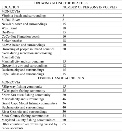
Liberia had maritime accidents over the years ranging from drowning of people along the beaches to capsizing of fishing canoe and fishing boat. Distress messages from merchant vessels were also received along the coast. Statistics of these accident were kept by the National Coast Guard, dating from 1975 to 1990 but were unfortunately destroyed during the nearly ten years civil war.
From 1990 to 1997 the civil war disorganized all military and political institution, and did not permit the recording of accidents, which was at its peak at that time
However, interview conducted in the pirogue fishing community and among beach operators shows that there were numerous cases of drowning along the coast and in the cities during the period 1980 to 1990.
Record on aircraft accident is not available due to the looting of abandoned offices during the civil war. However, the following is a basic statistic of accidents recorded during conversation with some employees of the James Spring Airport in Monrovia. These accidents have no survival due to lack of search and rescue facilities in the country. Some of the pilot in this accident parachuted when they encountered problem with their aircraft, but died because rescue did not arrived.
Table 1 show a list of aeronautic accidents and Table 2 a list of accidents caused by drowning.
AERONAUTIC ACCIDENTS
YEAR TYPE OF AIRCRAFT SURVIVAL
1976 Beech Baron 55 No survival
1981 Falcon 10 No survival
1984 Eurocopter EC 120 No survival
1986 Cessna 340 No survival
Table 1
DROWING ALONG THE BEACHES
LOCATION NUMBER OF PERSONS INVOLVED
MONROVIA
Virginia beach and surroundings 8
St Paul River 8
New-Kru town and surroundings 15
West Point 18
Du-River 15
CoCo-Nut Plantation beach 10
Sinkor beaches 18
ELWA beach and surroundings 10 Drowning of people in inland counties
rivers during recreation and crossing
50
Marshall City
Marshall city and surroundings 15 Greenvillie city and surroundings 12 Buchana city and surroundings 15 Cape Palmas and surroundings 15
FISHING CANOE ACCIDENTS MONROVIA
*Slip-way fishing community 15 *West point fishing community 25 *New.Kru town fishing community 20 Marshall city and surroundings 46 Grand Cape Mount fishing communities 36 Buchana city and surroundings 40 River Cess city and surroundings 30 Sinoe County fishing communities 34 Maryland County fishing communitues 50 Other counties river drowning caused by canoe accidents
65
. Table 2
In the 21.August 1989-sea accident involving two fishing vessels at St. Sulima Sierra Leone and Liberia border, many of the sailors died. The cause of the accident was lack of knowledge of Rules of the Road.
In April 1999, a vessel in distress along the coast of Liberia transmitted a distress signal, but was received by the Guinea Coastal radio station and relayed to Liberia. Liberia was not able to assist the vessel due to lack of SAR facilities.
In addition, the increase in drowning on the beaches across the country is due to lack of lifeguards, and training programs for such important personnel. There is no set rules and regulations that one should meet before operating a beach, i.e. Life Guards and rescue boats to assist any one drowning on the beach.
Numerous maritime disasters together with aeronautic accidents has brought about the integration of Maritime and Aeronautical Search and Rescue. The harmonizing of maritime and aeronautical search and rescue will assist states in meeting there own search and rescue (SAR) needs and the obligations they accepted under the Convention on International Civil Aviation, the International Convention on Maritime Search and Rescue and the International Convention for the Safety of Life at Sea (SOLAS).
SAR operations are usually considered as remedial solutions to accidents at sea, since the impact of a maritime and aeronautic accident largely depends on the degree of success of the SAR operation. The dedicated SAR system means that a 24 hour watch and supervision of all aeronautic and maritime activities in the SAR area is kept and the system is capable of responding to all the peculiar conditions prevailing in the area, so that everything and everybody operates within limited time.
Primary factors such as type of equipment in use, proficiency of SAR personnel, facilities available and the cohesiveness by which the whole operation is being conducted influence the quality of response, (Seaways, October 1989). The single most important factor in any SAR undertaking is how fast the information about an accident reaches a SAR Unit.
There is general conception that the complex and constantly changing maritime environment is contributory to maritime accidents. However, a study conducted by the U.S Coast Guard found that only 12% of maritime casualties are caused by poor visibility. It seems that most accident occur in clear weather with the other vessel clearly in sight, with well-established communication. It should be borne in mind that majority of accidents are caused by human error not by equipment failure and
channels, in coastal waters and even in the open oceans and seas far removed from land. For example, the “Herald of Free Enterprise” and the recent catastrophe of the “Estonia” all bear witness to the above statement.
1.7 OBJECTIVE FOR MAKING THE STUDY
The purpose for making the study is to analyze the present SAR situation regarding maritime and aeronautic search and rescue in Liberia, which is part of the maritime and aeronautic safety development plan as a whole, and suggest the ways and means to improve the system and facilities. The study is aimed at developing a comprehensive search and rescue program in Liberia. It introduces the coastline and climatical condition under which SAR will take place and identifying SAR resources in accordance with the basic requirements of the International Maritime and Aeronautic Search and Rescue Manual and the IMO.
In addition, the study discusses the development of a National Search and Reuse Manual and the Search and Rescue Plan. The integration of the National Coast Guard, National Fire Service, National Port Authority, Telecommunication Co-operation, Ministry of Health and Social welfare and National Red Cross Society and SAR resources providers into a comprehensive SAR program. This document when successfully completed will be used as a blue print for the implementation of Search and Rescue program in Liberia.
1.8 RESEARCH METHODS
In order to get information and data, besides the information given by: Resident professors, visiting professors and lecturers, the author has made some research using two methods. The two, methods are supporting, analysis and discussion of this subject in this paper regarding the maritime and aeronautic safety development concerning search and rescue in Liberia.
1.8.1 LIBRARY RESEARCH
This research was done by collecting information and data from the library of the World Maritime University, Malmö, Sweden and the Liberia Bureau of Maritime Library in Monrovia. The materials used are; text books, reports, the SAR
Convention and related material, International Maritime and Aeronautic Search and Rescue Manual, statistical tables, magazines, literatures and others which were very important and useful.
National Port Authority, the Marine department and Port Manager office, which were related with the maritime safety concerning search and rescue resources.
In addition, interviews were conducted at the Ministry of National Defense with Deputy Minister of Defense for Administration Colonel William concerning the overall Search and Rescue situation in Liberia after the Civil War. The Deputy Minister of Defense for Coast Guard Affairs, Mr. Leamah was interviewed about the current search and rescue operation in Liberia, and he highlighted the difficulties facing the National Coast Guard due to lack of logistics. Colonel Wallace of the National Coast Guard also provided useful information on search and rescue training in the National Coast Guard. The interview was extended to the office of the Director of the National Fire Service where the discussion was centered on the possible integration of his office with the National Coast Guard in Search and Rescue operation.
The final interview was conducted at the Liberia Bureau of Maritime Affairs with the Deputy Commissioner for Administration, Mr. Lami Kromah, about what was the cause of the delay in ratifying the Search and Rescue Convention, 1979 in Liberia. Mr. Kroma explained that every effort is being made to write the National Search and Rescue Plan and meeting is being conducted with the Coast Guard on how to start the SAR programs.
Information and data were obtained during the field trips arranged by the World Maritime University in Sweden, Denmark, Finland, Norway and Germany. Information was also obtained during field training in the United Kingdom.
1.9 ARRANGEMENT OF CONTENTS
The dissertation is divided into 7 (seven) chapters, which are explained below: Chapter I, deals with the introduction in order to describe the geographical and population situation in Liberia, the background of the study and its limitations, the aims and objectives of the dissertation, research methods adopted and arrangement of contents.
Chapter II deals with international SAR, the revised SAR Convention and the Global Maritime Distress and Safety System (GMDSS) legislation, and the role of the IMO in promoting safety at Sea with respect to Global and Regional SAR plan and co-operation.
Chapter III emphasis the importance of communication in SAR operations and the different ways of communicating, with special emphases on electronic and satellite communication system.
of the Liberia Civil War on SAR in the country and how to identify SAR resources in post war Liberia and manage the existing resources and equipment to provide SAR services.
CHAPTER II SEARCH AND RESCUE
2.1 GENERAL
The increase in maritime accident throughout the world since the sinking of the titanic in 1912, has caused concern. Due to the limitation in
communication technology and ship design, ship and its crew where lost at sea without anyone knowing what happen to them. Assistance to ships and persons in distress at sea is the oldest form of fraternity at sea.
Search and Rescue (SAR) is an operation co-ordinated by a rescue coordination center or rescue sub-center, using available personnel and facilities to locate persons in distress, retrieve them, provide for their initial medical or other needs, and deliver them to a place of safety. Obligation to render assistance to ships and people in distress at sea is enshrined in international conventions.
2.2 INTERNATIONAL CONVENTIONS
The international conventions listed below have taken into account the vital need to render assistance to persons and vessels in distress at sea.
• The Convention for the Unification of Certain Rules of Law relating to Assistance and Salvage at Sea. (Brussels, 1910) as amended.
• International Convention on the High Seas, adopted by the United Nations in 1958.
• The International Convention on Maritime Search and Rescue, (Hamburg, 1979, as amended).
Search and rescue provisions are found in the Brussels convention and SOLAS Convention. These conventions are upheld by Article 98 of the Law of the Sea Convention: Duty to render assistance, which states that
• Every state shall require the master of a ship flying its flag, in so far as he can do so without serious danger to the ship, the crew or the passengers:
(a) to render assistance to any person found at sea in danger of being lost; (b) to proceed with all possible speed to the rescue of persons in distress, if informed of their need of assistance, in so far as such action may reasonably be expected of him;
(c ) after a collision, to render assistance to the other ship, its crew and its passengers and, where possible, to inform the other ship of the name of his own ship, it’s port of registry and the nearest Port at which it will call.
According to the Brussels convention every master is bound, so far as he can do so without serious danger to his vessel, her crew and her passengers to render assistance to every body, even though an enemy found at sea in danger of being lost.
The Brussels Convention is an additional improvement of SOLAS Convention Chapter Regulation 10 that imposes obligation upon a master of a vessel to provide assistance, on receiving distress signal from any source such as survival craft, ship, small water craft and aircraft to proceed to the location of emergency and provide the appropriate assistance.
over the sea and, where a circumstance so require, by way of mutual regional arrangement co-operate with neighboring states for this purpose.
In SOLAS Chapter V, Regulation 15 each contacting Government is required to establish, operate and maintain such maritime safety facilities as are deemed practicable and necessary in accordance with the density of the sea going traffic to provide adequate means of rescuing people in distress. A Contracting
government to SOLAS is required to make available information concerning its existing rescue facilities and any plans for future changes.
An additional requirement for passenger vessels on fixed routes to which
Chapter 1 of SOLAS Convention applies became effective on 1 July 1997. They shall have on board a plan for co-operation with appropriate search and rescue services in event of an emergency. The plan shall be developed in co-operation with the ship and the search and rescue services and be approved by the administration. The plan shall include provisions for periodic exercises to be undertaken as agreed by passenger ship and the search and rescue services concerned to test its effectiveness.
The safety of passenger vessels is causing growing concern due to the trend towards ever-larger capacity cruise ships, couple with low standard design and a lack of organized safety evacuation procedures. Mr. William O’Neil, secretary-general of IMO expressed his concern by posing the questions, “How many ships would be needed to rescue 5000 passenger?” he asked. “ And even if they are safely evacuated, how will they be rescued?” How many ships today have the equipment that can pick shipwrecked survivors out of the water, at
Shipbuilding and Machinery and Marine Technology trade fair in Hamburg, Germany. 23 NOVOVEMBER 98 WORLD: SAFETY CONCERNS SURFACE AS CRUISE SHIPS GET BIGGER. By Fleix Chan. (SINGAPORE)
The dream of the 6,200 passenger/2,400 crew America World City may never happen nor may plans for the Cruise Bowl with its 12,000 passengers. Mr. O’Neal’s vision of a future Titanic is disturbing. Taking a closer looks at present search and rescue facilities, Coast Guards helicopters could never handle 5,000 survivors. This will depend on how quickly other vessels reach the scene. If they arrive on time, not all vessels are equipped to pulled people out of the sea. Besides passenger vessels which tend to have platform and fast rescue boats, the average commercial vessel is capable of rescuing two or three people from the sea or survival craft, but this is a slow and painstaking procedure and inappropriate for a 5000 passengers cruise ships, hence a second Titanic. The 50 per cent chance that the rescue would take place at night under severe weather condition is a logistical nightmare. It is about time new technology and regulation on search and rescue is put into contemplation.
The incident of the Titanic when 1500 passengers were shipwrecked reminds us about the consequences when safety technology has not kept up with the
capacity of modern cruise ships. The size and capabilities of SAR facilities and co-ordination in most Sea-area of the world does not match the size of modern cruise ship passenger capacity. The 50 percent possibility of night rescue is a food for thought.
2.3 THE INTERNATIONAL CONVENTION ON MARITIME SEARCH AND RESCUE 1979, AND REVISED CONVENTION
• to develop an international maritime search and rescue plan;
• to promote regional co-operation among search and rescue organizations; • to co-ordinate activities regarding safety on and over the sea among national
and international organizations;
• to encourage government to establish, operate and maintain facilities to assist vessels in distress;
• to provide assistance to persons in distress at sea;
2.4 GENERAL OUTLOOK OF THE SEARCH AND RESCUE CONVENTION, 1979
The search and rescue convention contains six chapters
2.4.1 TERMS AND DEFINATIONS
Chapter 1 comprises Terms and Definations
2.4.2 ORGANIZATION
Chapter 2 of this convention deals with basic structure for establishing a search and rescue Organization. Contracting states are required to send to the
2.4.3 CO-OPERATION
Chapter 3 approved those parties in addition to their own search and rescue establishment should also co-operate with neighboring states. Provisions should be made in the national legislation to empower the parties’ immediate entry into or other territorial sea or territories or rescue units of each other solely for the purpose of search and rescue operations.
Neighboring states should upon establishing SAR agreement provide for expediting entry of RCCs units into each other territorial waters with the least possible formalities. Each party should permit its RCCs:
• to appeal for and render such assistance including personnel, vessels, aircraft or equipment, as may be needed from or by other co-ordination centers.
• to grant any necessary permission for entry of external personnel or equipment into or over its territorial sea or territory, and to make the
necessary arrangements with the appropriate customs, immigration, health and other authorities.
2.4.4 PREPARATORY MEASURES
The RCCs and RSCs should have ready access to information regarding and how to contact them, the position, course and speed of vessels within its area that may be able to provide assistance to persons, vessels or other craft in distress.
2.4.5 OPERATIONAL PROCEDURES
Chapter 5 deals with requirement for parties to ensure continuous radio watches are kept on international distress frequencies. It provides initial action to be taken by search and rescue units upon receiving information of a distress incident.
The operational procedures followed three main emergency phases:
1. Uncertainty phase: when a person has been reported as missing or a vessel or other craft is overdue; or when a person, a vessel or other craft fail to make an expected position or safety report;
2. Alerting phase: when attempts to contact a person a vessel or other craft and inquiries to other appropriate sources have been unsuccessful or when information received indicate that operating efficiency of a vessel or other craft is impaired, but a distress situation is unlikely;
3 Distress phase: when positive information is received that a person a vessel or other craft is in danger and need immediate assistance or further
unsuccessful attempt to establish contact with a person, a vessel has failed and the probability that the vessel is in distress, or that the operating efficiency of a vessel or other craft has been impaired to the extent that a distress situation is likely.
• Co-ordination when two or more parties are involved. • On-scene co-ordination of search and rescue activities • termination and suspension of search and rescue operations • Designation of on-scene co-ordinator and responsibilities. • Designation of co-ordinator surface search and responsibilities • Initiation of search and rescue operation when the position of the search object is unknown.
• Passing information to persons, vessels or other craft for which an emergency phase has been declared.
2.4.6 SHIP REPORTING SYSTEMS
Chapter 6 recommends establishing a ship reporting system individually by parties or in co-operation with other states if necessary to facilitate search and rescue operations. The system should provide up to date information on the movement of vessels in order to reduce the interval between the loss of contact with a vessel and the initiation of search and rescue operations.
The Ship reporting system should provide information on vessel’s movements, including sailing plans and position reports, maintains of a shipping plot and receive report at appropriate intervals from participating vessels. The system should be simple in design and operation and use an internationally agreed standard ship reporting format and procedures of IMO Assembly Resolution A. 648 (16).
2.4.7 SEARCH AND RESCUE RESOURCES
departments for assistance, as private Organization may demand considerable payment for services. Examples of public sources for SAR assistance are: • Broadcasting stations; Communication networks and public information
broadcasts,
• Civil aviation administrations; Air traffic services personnel, communications networks, and departmental aircraft,
• Coastguard and lifeboat authorities; where established this authorities are the primary source of maritime SAR assistance,
• Electric and public works departments; first aid personnel, helicopters, and communication lines,
• Fire departments; the general public turns for help or to report an accident, they may provide rescue units including fire fighting brigades, emergency medical technician and vessels,
• Health departments; hospital and first-aid facilities, ambulances, and emergency medical stations in remote areas,
• Hydrographic and other marine survey departments; marine navigation warnings and information and vessels,
• Lighthouse and pilottage authorities; vessels and crews,
• Marine and fisheries departments; vessels and crews, and vessel reporting systems,
• Military services; military services are the best source of all-weather facilities and trained personnel in SAR capabilities. Police departments; Police departments are public focal point for reporting abnormal observation. They may provide:
- alerting post,
- Communication facilities, - traffic control,
2.4.7.1 COMMUNICATION FACILITIES
Communications are very important to effective SAR operations
system provides means of receiving distress alerts and direct the efforts of responding
facilities. SAR manager should ensure that each RCC has access to the following communications networks:
• air traffic services networks; • amateur radio stations;
• State-owned and private broadcasting stations; • cable, telephone and telegraphic co-operations; • coast radio stations;
• meteorological communication networks; • military communications networks; • railway communications system:
• dedicated SAR communications networks;
• satellite communications systems, e.g., INMARSAT and COSPAS-SARSAT; and transport communications systems.
2.4.7.2 AIRCRAFT OPERATING AGENCIES
Arrangements should be made with aircraft operating agencies and for their co-operation in SAR. They may provide assistance by;
making suitable aircraft and crew available for SAR operations;
• requesting air crew to keep a visual or radio watch for aircraft or vessel lost in the vicinity of their route;
2.4.7.3.MERCHANT VESSELS
International conventions recommend that the master of a vessel, on receiving a message that persons are in distress at sea, should proceed to
assist them when it can be done without undue risk to the safety of the
responding vessel and crew. Vessels at sea are potential SAR assets. Fishing vessels, yachts and small crafts are sources from which volunteer assistance may be obtained.
2.5 PROBLEMS ENCOUNTERED WITH THE 1979 SAR CONVENTION
The SAR Convention of 1979 was designed to provide the framework for search and rescue operations. It and the two-associated manual, together with other resolutions recommendations adopted at the 1979 conference, should ensure that such operations are conducted with maximum speed and efficiency, no matter where the distress incident occurs. However, its productiveness relies in turn on the action taken by the parties to the Convention.
Because the Convention imposes considerable obligations on parties- such as setting up the shore installations, many countries have not ratified the
convention. By the end of 1997, for example, the SAR convention had been ratified by only 56 countries, who’s combined merchant fleets represented less than 50% of the world’s tonnage. Equally important, many of the world’s coastal States had not accepted the Convention and the obligations it imposes.
As a result, the development of 13 areas SAR plans has been relatively slow and by 1995, ten years after the Convention entered into force, provisional SAR plans had only been drawn up for nine regions. It was commonly decided that one reason for the small number of acceptance and the slow pace of
these could best be overcome by amending the Convention. Consequently, a meeting was held in October 1995 in Hamburg, Germany to reflect on the problem and it was decided that there were substantial concerns that require action to be taken into account including:
• experiences of States which have implemented the Convention;
• questions and concerns posed especially by developing States which are not yet parties to the Convention;
• needed improvements to IMOSAR and MERSAR, the two IMO SAR Manuals which are prevented by the present wording of the convention: • need to further harmonize the IMO and ICAO SAR provisions;
• difficulties in finalizing the IMO SAR Plan which result from the present Convention; and
• inconsistent use of Convention terminology and phraseology.
2.6 THE REVISED CONVENTION
The subcommittee on Radio-communications and Search and Rescue
(COMSAR) was requested to revise the Convention. A draft text was prepared and was approved by the 68th session of the MSC in May 1997. It was put forward for adoption by the 69th MSC session in May 1998. It is hoped that revised Convention will enter into force in the year 2000.
In the revised SAR Convention, terms and definitions embody in
• a legal framework;
• assignment of responsible authority; • Organization of available resources; • co-ordination of operational functions; and
• processes to improve the service, including planning, domestic and co-operative relationship and training.
Chapter 2 describes the Organization of SAR services and how national
capabilities are developed. Parties are required to establish rescue co-ordination centers and to operate them on a 24-hour basis with staff having a working knowledge of English.
Chapter 3 contained co-operation among States and Chapter 4 deals with Operating Procedures, but incorporates a Revised Version of the of the original Chapter 4 on preparatory measures. The original Chapter 6 (Ship Reporting Systems) has been updated and renumbered as Chapter 5.
2.6.1 THE IAMSAR MANUAL
The significant innovation of the revision of the SAR Convention is the
importance now being placed on the co-ordination of maritime and aeronautical SAR operations. IMO and the International Civil Aviation Organization (ICAO) have established a Joint Working group on the harmonization of aeronautical and maritime SAR operations. The joint group has its fifth meeting in Colonial Williamsburg, United States in October 1997 and prepared the International Aeronautical and Maritime Search and Rescue (IAMSAR) Manual.
needs and obligations they have accepted under the Convention on
International Civil Aviation, the International Maritime Search and Rescue and the International Convention for the Safety of Life at Sea. The manual provides guidelines for a common aviation and maritime approach to organizing and providing SAR service.
The Mobile Facilities volume is intended to carry rescue units, civil aircraft and vessels to help with performance of a search, rescue or on-scene co-ordination function and with aspects of SAR that pertain to their own emergencies.
The IAMSAR Manual will replace both the MERSAR and IMOSAR Manuals.
2.6.2. DEVELOPING THE GLOBAL SAR PLAN
Major effort has been made in the past few years to improve the implementation of the SAR Convention. One by one the gaps in the 13 SAR areas have been filled, a decisive moment was in September 1997 when coastal States agreed on provisional SAR plans for the Mediterranean and Black Seas.
The development of SAR plans in all the world’s sea areas is important not only to the success of the SAR Convention but to the implementation of another IMO innovation which has already made a major contribution to shipping safety and has already saved many lives at sea.
2.6.3 THE SAR CONVENTION AND GMDSS
The GMDSS is essentially a worldwide network of automated emergency
communications for ships at sea. The basic concept is that searches and rescue authorities ashore as well as shipping in the immediate vicinity of the ship in distress; will be rapidly alerted through satellite and terrestrial communication techniques to a distress incident so that they can assist in a coordinated SAR operation with the minimum of delay.
The 1979 SAR Convention was designed to provide for responding to emergencies and the GMDSS was established to provide it with the efficient communication support needed. Both the GMDSS and SAR are crucial to the future of maritime safety and when both are fully operational, any emergency at sea will result in a distress call and the response to that call will be immediate and effective. The days when ship and it crew could vanish at sea without trace should then hopefully be ended
2.7 INTERNATIONA L ORGANIZATION ON SEARCH AND RESCUE
International standards are set by international organizations formed to promote international co-operation on SAR among nations signatory to the convention. Important international organizations and agencies are described below.
2.7.1 INTERNATIONAL MARITIME ORGANIZATION (I.M.O.)
IMO is a branch of the United Nations that provides machinery for co-operation and exchange of information among governments on technical matters affecting shipping engaged in international trade. It administers the conventions on
Convention, IMO requires merchant vessels to respond to distress signals and carry life saving appliances including radio equipment with automatic alarm devices. In 1979, IMO adopted the International Convention on Maritime Search and Rescue whose aim was to develop International SAR Plan resulting in, no matter where an accident occurs, the rescue of persons in distress at sea will be co-ordinated by a SAR organizations and, when necessary, by co-operation between neighboring SAR organizations.
The International Code of Signals (INTERCO) includes sections on emergencies, distress and SAR.
IMO’s Merchant Ship SAR Manual (MERSAR) comprises procedures for merchant ships involved in SAR.
IMO Search and Rescue Manual (IMOSAR) assist government to implement the SAR Convention, and provides outlines for a common maritime SAR policy. It encourages coastal states to co-operate and provide mutual assistance
2.7.2 INTERNATIONAL CIVIL AVIATION ORGANIZATION (I.C.A.O.)
2.7.2 INTERNATIONAL TELECOMMUNICATION UNION (ITU)
ITU is an intergovernmental agency related to the United Nations. It adopts international regulations and treaties governing all terrestrial and space uses of the frequency spectrum as well as the use of the geostationary satellite orbit within which countries adopt their national legislation. ITU develops standards to facilitate interconnection of telecommunication systems on a worldwide scale. ITU prescribe the frequencies for uncertainty alert, distress, emergency and safety messages. It provides emergency information to organization concerned with Safety of Life at Sea about ship in distress or need of assistance.
2.7.3 INTERNATIONAL RADIO MEDICAL CENTRE (C.I.R.M.)
C.I.R.M is a humanitarian Organization with headquarters in Rome, Italy. It provides humanitarian medical services and assist in arranging the removal of injured or strongly ill seafarers from vessels worldwide. CIRM furnish facilities where no medical advice is accessible.
2.8 IMO ROLE IN PROMOTING MARITIME SAFETY
2.8.1 LIFE SAVING APPLIANCES AND SAFETY DRILLS
IMO has made provision and improvement of life saving equipment and techniques to ensure safety at sea. The Maritime Safety Committee has adopted International Life Saving Appliances Code in order to provide international standards for life-saving appliances required by SOLAS.
Ships are provided with life-saving equipment and survival crafts sufficient for all persons on board and to quickly and safely launched in case of an emergency. These appliances are made to save and maintain life for a specific period of time or until they are rescued.
survival crafts.
2.8.2 TRAINING MANUAL
Life-saving appliances are provided with training manual. Such manual should contain instructions and information in easily understood terms on their use and method of survival. Part of the information should be in the form of audio-visual aid in lieu of the manual. The manual should explain the instruction on
maintenance and safe use of the survival equipment.
2.8.3 DISTRESS ALERTING AND SIGNALLING
development. Passenger vessels, irrespective of size and cargo vessels of 300 GRT and above must carry at least 2 two-way VHF radiotelephone equipment.
2.8.4 GMDSS DISTRESS ALERTING
The basic concept of the GMDSS is that SAR authority ashore, in addition to shipping in the immediate vicinity of a casualty, must be rapidly alerted to a distress incident so that they can assist in a co-ordinated SAR operation with minimum of delay.
IMO specified nine function ship carriage requirements for radio communications equipment in the specific sea areas in which the vessel trades. The nine
functions are:
• Distress alerting; ship to shore.
• Transmitting and receiving distress alerts: ship to ship.
• Transmitting and receiving SAR co-ordination communications. • Transmitting and receiving on-scene communications.
• Transmitting and receiving locating signals.
• Transmitting/receiving maritime safety information (MSI).
• Transmitting and receiving general radio communications from shore-based radio networks.
• Bridge to bridge two way communications.
To achieve ship to shore distress alerting there must be a means of transmitting ship to shore distress alerts by at least two separate and independent methods, each using a different radio communications service.
8.5 GMDSS SHIP CARRIAGE REQUIREMENTS
500 grt) water proof VHF handheld transceivers for on-scene communication, MF communication on 2182 KHz until February 1999. Other equipment will be fitted depending upon the geographical areas through which the ship trade. (UNDERSTANDING GMDSS, Calcutta, D and Tatley, L 1994)travels on
The GMDSS communications system under SOLAS complements the
International Convention on Maritime Search and Rescue (SAR), 1979. It was adopted to develop a global SAR plan, so that no matter where an incident occurs, the rescue of persons in distress will be co-ordinated by a SAR
organization and where necessary, by co-ordination between neighboring SAR countries.
From 1 February 1999, all passenger vessels and all cargo vessels of 300 gross Tons and upward on international voyages must comply with GMDSS.
IMO and the International Hydrographic Organization (IHO) have established World Wide Navigational Warning System (WWNWS). The system divides the world oceans into sixteen areas called NAVAREA. It is for long range NAVAREA warnings and coastal NAVTEX warnings. It provides for globally co-ordinated transmissions with NAVAREA Co-ordinators for each NAVAREA. The purpose of the system is to promulgate rapid transmission and reception of distress messages and navigation and safety warnings to vessels. Warnings which SAR personnel may send over WWNWS include:
• distress alerts
• information about overdue or missing aircraft or vessels Collectively, these types of alerts, combined with navigation and meteorological warnings, are called maritime safety information (MSI).
organizations, confusion exists due to language barriers. The international language of SAR is English, even then certain phases and words can be misinterpreted by the parties at both ends. To overcome this problem, IMO Assembly has adjusted and standardized the English terms used at sea. Where neighboring States use language other than English, it is useful to have
someone at the RCC or on call capable in that language too. Advantage can also be taken of the increasing trend of communication service providers to offer translating services on the telephone. However, every RCC should always have personnel on watch, who is able to speak, read, and write the English language to enable timely and effective communications with aircraft, vessels, and other RCCs.
2.8.6 ABANDONING SHIP AND SURVIVAL TECHNIQUES
Many ships are abandoned or sink without affording the crew enough time to prepare for the emergency. The greatest danger to life after abandoning vessel is the lost of body heat (hypothermia). When body core temperatures fall below 35 degree centigrade the person is suffering from hypothermia. Drowning is the secondary cause of death. Many of those who drown did so because of
incapacitation due to cold.
are included in the code to provide protection against hypothermia. IMO publication, `A pocket guide to cold water survival ´, gives practical advice on cold water survival and how to treat victims.
2.8.7 SEARCH AND RESCUE PHASES
IMO has been concentrating its efforts on developing a worldwide-integrated system to respond to vessels in distress. The most significant of these are the SOLAS conventions of 1974, the International Convention on Maritime Search and Rescue (SAR), and the Global Maritime Distress and Safety System (GMDSS).
2.8 IMO SEARCH AND RESCUE MANUAL (IMOSAR)
The main purpose of IMO SAR manual is to assist government in implementing the objective of the International Convention on Maritime Search and Rescue, 1979. It provide guidelines on maritime search and rescue policy, encouraging coastal states to develop their program on similar framework and enabling neighboring states to co-operate and provide mutual assistance.
2.8.1 MERCHANT SHIP SAR MANUAL (MERSAR)
The purpose of the manual is to provide guidance for those whom during emergencies at sea may require assistance from others or who may be able to render such assistance themselves. In particular, it is designed to aid the master of any vessel who might be called upon to conduct search and rescue
responsibilities for assistance at sea. It is accepted as normal practice for seafarers, certainly there is an obligation upon masters, that they render every assistance within their power in case where a person or persons are in distress at sea (MERSAR) 1993.
2.9 GLOBAL MARITIME SAR PLAN’
The world oceans have been divided into different areas for the development of global SAR Plan. The development of SAR Plans in all world sea areas is important not only to the success of the SAR Convention but to the
implementation of the Global Maritime Distress and Safety System (GMDSS).
Member’s governments within such areas are asked to provide necessary information with view to prepare a provisional maritime SAR Plan in accordance with the provisions of the 1979 SAR Convention. The areas is divided in 13 sea areas, these areas are as follows:
Area-1 North Atlantic Area-2 North Sea
Area-3 Baltic Sea
Area-4 Eastern South Atlantic Area-5 Western South Atlantic Area-6 Eastern North Pacific
Area-7 Western North Pacific Area-8 Eastern South Pacific
Area-9 Western South Pacific Area-10A North West Indian Ocean
Area-10B South West Indian Ocean Area-10C East Indian Ocean
Area-12A Black Sea Area-13 Arctic Ocean
These World Sea Areas are, in addition, sub-divided into smaller regions for the relevant coastal states to develop their SAR plans agreeably As a result, Liberia falls within Area-4 Eastern South Atlantic of the World Sea Areas. Countries within the Area-4 Eastern South Atlantic are;
.1 Angola .2 Benin.3 .3 Cameroon .4 Cape Verde .5 Congo
.6 Equatorial Guinea .7 Gabon
.8 Gambia .9 Ghana .10 Guinea
.11 Guinea Bissau .12 Cote d’Ivoire .13 Liberia .14 Mauritania .15 Morocco
.16 Namibia .17 Nigeria
.18 Sao Tome and Principe .19 Senegal
.20 Sierra Leone .21 South Africa
These countries are obligated to establish MRCC in their respective sea area for the performance of SAR operations. Due to the large number of members in Area-4 it was found prudent to establish committees for area discussions and development of Area Maritime SAR Plans with participation as follows;
1 North Western Sector Committees
Mauritania, Cape Verde, Senegal, Gambia, Guinea-Bissau, Guinea, Sierra Leone, Liberia, Cote d’Ivoire, Ghana and Togo.
2 South-Eastern Sector Committee
Benin, Nigeria, Cameroon, Equatorial Guinea, Sao Tome and Principe, Gabon, Congo, St Helena, Zaire, Angola, Namibia.
2.9.1 REGIONAL CO-OPERATION ON SAR
On the 16th to 20th May 1988 the West African Region held it first seminar and workshop devoted entirely to maritime search and rescue in Lagos, Nigeria. Similar meetings have been held in Asia and the Pacific and in the Caribbean regions. The occasion was organized by IMO and financed by the United
Nations Development Program (UNDP). Liberia was assigned SAR zone during the seminar, see Figure 2 .
The aim of the workshop and seminar were;
• to assist developing countries in the region to establish and improve their maritime search and rescue capabilities in accordance with SOLAS Chapter V.
• to encourage early implementation of the International Convention
on Maritime Search and Rescue, 1979, and also the Global Maritime Distress and Safety System (GMDSS) on regional level.
CHAPTER III
SAR COMMUNICATIONS AND OPERATION 3.1 GENERAL
SAR communication is considered one of the most important and sometimes the weak link in the SAR system. What matters is the overall timeliness and quality of communication from their source to the final destinations. Therefore, all sea, land, air and space segments must be examined to eliminate weak links, delays, and
deterioration of quality. SAR communications must be able to take place reliably and quickly between units in distress and the SAR system, and also between components of the SAR system, nationally and internationally.
3.2 DISTRESS COMMUNICATIONS
Distress communication includes all messages relating to immediate assistance required by persons, aircraft, or marine craft in distress, including medical assistance. Distress communication may also include SAR communications and on-scene
communications. Distress communications take absolute priority over all transmissions; anyone receiving a distress call must immediately cease any transmission that may interfere with the call and listen on the called frequency.
Distress alerts may reach RCCs from diversity of equipment sources and through a variety of alerting posts. Alerting posts includes, coast radio stations (CRSs), Local User Terminals (LUTs) and Mission Control Centres (MCCs) of the Copas-Sarsat System. Other includes Land Earth Stations (LESs) of the Inmarsat System, Air Traffic Services (ATS) units, public safety units such as police and Fire department, and vessels, aircraft, or other persons or facilities that relay distress alert between their source and the responsible RCC, and may even include other RCCs.
3.3 DISTRESS SIGNALS
According to international agreements, certain signs and signals indicate distress or emergency. Such signs or signals are inscribed in the International Code of Signals. Common maritime and aeronautical signals must be listed in the SAR plans, and SRUs should carry a copy of the International Code of signals.
3.4 VISUAL, AURAL AND ELECTRONIC SIGNAL
Visual signing equipment for part of the Life Saving Appliances, such equipment includes:
• Daylight visual signal: fluorescent materials, sea dye markers or smoke signal
• The voice or aural signals are usually considered the most practicable means of communication for directing on-scene operations. The most common facilities used are telephones, radiotelephones and INMASAT. A voice distress signal is preceded by the word mayday. 156.8 MHz (Channel 16) is the international VHF maritime voice distress, safety, and calling frequency. The frequency 156.3 MHz (Channel 06) may be used for communications on-scene.
3.5 SPOKEN EMERGENCY SIGNALS
There are three spoken emergency signals used by aircraft and vessels:
Distress signal: MAYDAY (pronounced M’AIDER) is used to indicate that a mobile craft is in distress and requires immediate assistance, and has priority over all other communication. For example, man overboard message.
Urgency signal: PANPAN (pronounced PAHN-PAHN) is used when the safety of a mobile craft is in jeopardy or an unsafe situation exist that may eventually involve a need for assistance, and has priority over all distress traffic.
Safety signal: SECURITY (pronounced SECURITAY) is used for messages concerning safety of navigation or giving important meteorological warnings.
Any Aircraft commander or vessel captain experiencing a distress situation should declare a distress condition using the MAYDAY signal. However, if these words are not used, and there is any doubt whether an emergency exists, the hearer should assume it is an actual or potential emergency and obtains enough information to handle the emergency intelligently.
3.6 ELECTRONIC SIGNALS
Emergency electronic signals come in the form of radio alarms. International radio alarms are used to alert ships, aircraft and radio stations during an emergency situation. Several frequencies in different radio bands are assigned for distress, urgency, safety, or SAR signals and messages. It is very important that SAR personnel thoroughly understand the frequencies and their authorised use. The frequencies used includes:
Hz, alternating 4-times per second and continued for 30 seconds to 1 minute. It is transmitted on 2182 kHz or 156.8 kHz (Channel 16) during alert or emergency situations to attract attention and actuate automatic alarm devices.
3.6.1 DIGITIL SELECTIVE CALLING (DSC)
Digital selective calling is used for distress alerting and safety calling on terrestrial frequency. The frequencies are HF, MF and VHF. Frequencies assigned for distress and safety purposes are:
• MF band: 2,187.5 kHz
• HF band: 4,207.5 kHz, 6312KHz, 8414.5 kHz, 12577 kHz and 16,804.5 kHz
• VHF band: 156.525 MHz (Channel 70)
These frequencies when used actuate the receiving selectors on all ships that are equipped with digital selective calling regardless of code number. The total duration of All Ship Call signals should be at least 5 seconds.
3.6.2 EMERGENCY POSITION INDICATING RADIO BEACON (EPIRBs)
Two types of maritime satellite Emergency Position Indicating Radio Beacons have been accepted into GMDSS. They are devices that transmit radio signals either on 1.6 GHz (the Inmarsat frequency) or the 406 MHz frequency used by the COPAS-SARSAT system. These are fully automatic, semi-automatic, or hand activated. They may be transmitters, transceivers, beacon only, or a combination. Worldwide
coverage is only possible with satellite EPIRBs operating on 406 MHz as those operating on the aeronautical emergency frequency 212.5 MHz or 243 MHz can only be received when an LUT is within the satellite’s footprint.
3.6.3 RADAR TRANSPONDERS
The main difficulty during SAR operation is simply locating the survivors. In many cases the distress alert will have been sent by the ship or automatically by the satellite EPIRB and survivors will have embarked into survival craft. Radar
transponders are the device that assists rescue units to locate ships and survival craft by day or night in all weather conditions. Receiving and radar pulse activates it. It then sends out a series of pulses that are display on the radar screen of the
3.6.4 AUTOMATED MUTUAL ASSISTANCE VESSEL RESCUE SYSTEM (AMVER)
AMVER is a world-wide-computerised ship reporting system operating exclusively to support SAR and make information available to all RCCs. It is a system for maintaining the dead reckoning navigation position of participating merchant vessels. Any merchant vessel of 1000 gross tons or more on any voyage or greater than 24 hours is welcome to participate by sending movement reports and periodic position reports voluntarily to the AMVER centre in New York via designated coastal or appropriate radio stations. Any vessel between 80 degrees North and 80 degrees south worldwide may participate. The SAR data collected is published periodically to AMVER bulletins and distributed to RCCs.
Where communication link exist, AMBER centre can produce a surface picture of vessels in the area of SAR incidents, together with predicted positions and their characteristics. The surface picture (SURPIC) may be requested in two formats.
1. Circle SURPIC giving latitude and a longitude with a radius of up to 200 miles. 2. Area SURPIC of any shaped area bounded by no more than 100 reference points,
i.e. a square search area would have four reference points. Benefits of participation include:
• Improved likelihood of rapid assistance during emergencies
• Reduced number of calls for assistance to vessels unfavourably located to respond
• Reduce response time to provide assistance
• To provide medical advice or assistance to distress vessel, when a doctor is not on board.
3.7 AN INTRODUCTION TO SATELLITE COMMUNICATIONS
Satellite offered a solution to the problem with radio messages travelling in straight line. Because they do not follow the curve of the Earth’s surface eventually they disappear in space (except on HF). Radio messages sent via a satellite also travel in straight lines, but they can immediately be re-directed from the satellite back to Earth, greatly extending the range of communications. Satellite enables a message to be sent to a satellite and then back t a dedicated station on land that is designed and equipped to deal with such emergencies. It provides an immediate respond to emergency situation.
Inmarsat (International Maritime Satellite Organisation) the convention on Inmarsat was adopted in 1976 by IMO and entered into force in 1979 and Inmarsat became operational in February 1982.
The Inmarsat system was established for the following purposes:
• To make provision for the space segment necessary for improving maritime communication and aeronautical communications as practicable,
• Assisting in improving distress and safety of life, communication for air traffic services.
• Efficiency and management of ships and aircraft communication,
• Maritime and aeronautical public correspondence services and radio determination capabilities.
3.7.1 THE INMARSAT SYSTEM
The major components of Inmarsat are:
• Space segment
• Operations control centre (OCC)
• Coast Earth Stations (CES)
• Network co-ordination stations (NCS)
Inmarsat uses a satellite in each of the areas listed below. Together the satellites provide coverage along the entire equator between 70 degrees latitude north and South, and serve aeronautical, land and maritime users.
Atlantic Ocean Region-East (AOR – E) Pacific Ocean Region (POR)
Indian Ocean Region (IOR)
Atlantic Ocean Region – West (AOR – W)
3.7.2 THE SPACE SEGMENT
The four space crafts in geo-stationary orbit 35700 Km above the equator and located over Atlantic Ocean region – West, Atlantic Ocean region – east, Indian Ocean region and Pacific Ocean region.
3.7.3 THE NETWORK COORDINATION STATIONS (NCSs)