https://doi.org/10.5194/gi-8-277-2019
© Author(s) 2019. This work is distributed under the Creative Commons Attribution 4.0 License.
A universal and multi-dimensional model for
analytical data on geological samples
Yutong He1, Di Tian2, Hongxia Wang2, Li Yao3, Miao Yu1, and Pengfei Chen4
1School of Electronic Information Engineering, University of Electronic Science and Technology, Zhongshan Institute, Zhongshan, Guangdong, China
2College of Instrumentation & Electrical Engineering, Jilin University, Changchun, Jilin, China 3College of Earth Science, Jilin University, Jilin, China
4The 41st research institute CETC, Qingdao, China
Correspondence:Di Tian ([email protected]) and Miao Yu ([email protected]) Received: 26 August 2018 – Discussion started: 8 May 2019
Revised: 29 July 2019 – Accepted: 20 August 2019 – Published: 30 October 2019
Abstract.To promote the sharing and reutilization of geoan-alytical data, various geoangeoan-alytical databases have been es-tablished over the last 30 years. Data models, which form the core of a database, are themselves the subjects of in-tensive studies. Data models determine the contents stored in the databases and applications of the databases. However, most geoanalytical data models have been designed for spe-cific geological applications, which has led to strong het-erogeneity between databases. It is therefore difficult for re-searchers to communicate and integrate geoanalytical data between databases. In particular, every time a new database is constructed, the time-consuming process of redesigning a data model significantly increases the development cy-cle. This study introduces a new data model that is uni-versally applicable and highly efficient. The data model is applied to various geoanalytical methods and correspond-ing applications, and comprehensive analytical data contents together with associated background metadata are summa-rized and catalogued. Universal data attributes are then de-signed based on these metadata, which means that the model can be used for any geoanalytical database. Additionally, a multi-dimensional data mode is adopted, providing geologi-cal researchers with the ability to analyze geoanalytigeologi-cal data from six or more dimensions with high efficiency. Part of the model is implemented with the typical database system (MySQL) and comprehensive comparison experiments with existing geoanalytical data model are presented. The result unambiguously proves that the data model developed in this paper exceeds existing models in efficiency.
1 Introduction
a data model for environmental geochemical surveying and mineral resource exploration in the United States of America (Jr and Miesch, 1977). Lehnert et al. (2000) suggested a data model for the storage of global geochemical data of rocks. Their data model provides a complete summary of essen-tial geochemical data contents and a robust structure with a relational database management system (RDBMS). Numer-ous databases such as GEOROC (Geochemistry of Rocks of the Oceans and Continents), NAVDAT (the North Ameri-can VolAmeri-canic and Intrusive Rock Database), and PetDB (the interactive web-based Petrological Database of the Ocean Floor) have since been constructed based on this model, and it is used by geological researches worldwide. In particular, PetDB has been used for a considerable amount of high-impact research such asNature(Brandl et al., 2013; Carbotte et al., 2013; Cheng et al., 2016; Dick and Zhou, 2014; Helo et al., 2011; Hoernle et al., 2011; Kamenov et al., 2011; Kel-ley, 2014; Samuel and King, 2014; Schlindwein and Schmid, 2016; Straub et al., 2009) and Science (Cottrell and Kel-ley, 2013; Greber et al., 2017; Joy et al., 2012; Kelley and Cottrell, 2009; Mcnutt et al., 2016). A limitation of exist-ing geoanalytical data models is their specificity to particu-lar applications or geological domains and their focus on the description and curation of only a certain portion of geoan-alytical data. For example, RU_CAGeochem is specifically focused on major and trace element concentrations and Sr, Nd, and Pb isotopic ratios of American volcanic rocks (Carr et al., 2014). Another database is focused on lead isotopes of copper ores from the southeastern Alps (Artioli et al., 2016). Many other examples of similarly specific geoanalyti-cal databases and associated models exist (e.g., Artioli et al., 2016; Hellström, 2016; Lopes et al., 2014; Siegel et al., 2012; Strong et al., 2016). The consequence of this development is that each database exists as a separate island, and it is difficult for researchers to communicate and integrate geoanalytical data between databases. In particular, every time a database is constructed, a data model has to be redesigned. This con-sumes considerable amounts of time and prolongs the de-velopment cycle. In addition, the vast majority of models are designed based on relational models, which focus on the construction of relations between different data categories. When users query and utilize the geoanalytical data from different dimensions, these types of models utilize
compli-develop a multi-dimensional data model. Finally, we evalu-ate the model to validevalu-ate its efficiency.
2 Overview of geoanalytical data contents
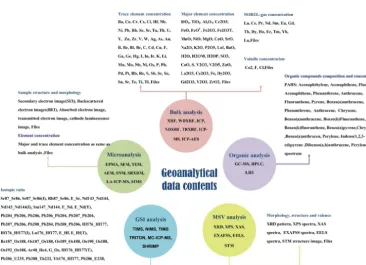
analyt-Figure 1.Process of summarizing the geoanalytical data contents.
Figure 2.Lists of geoanalytical methods and measurement data items.
ical method which is used for the analysis of environmen-tal geological samples. The most common application of this method in the geological literature is the analysis of the 16 kinds of polycyclic aromatic hydrocarbons (PAHs) in soils.
Background information describing the analyzed samples and data quality has to be incorporated, because it is indis-pensable for proper evaluation, efficient recovery, and sort-ing of the compiled data. Hence, background metadata are summarized based on the investigations of the geological re-searchers and the contents of existing databases (Adcock et al., 2003; Lehnert et al., 2000). Table 1 lists details of the background metadata used during the present study. In this study, the background metadata are divided into three parts: sample metadata provide geological researchers with
infor-Table 1.Background metadata of geoanalytical data.
Background metadata
Sample metadata sample type, sample name, sample description
Sampling metadata sampling site description, longitude, latitude, sampling methods, sam-pling depth, samsam-pling institution
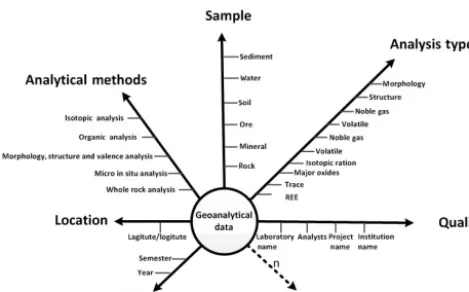
Figure 3. Multi-dimensional conceptual data model (CDM) for geoanalytical data.
mation about geological materials, sampling metadata pro-vide information about environmental conditions in the field, and quality metadata allow geological researchers to make an assessment of data quality and usability (Table 1). The background metadata items listed in Table 1 are the most es-sential information required for every kind of geoanalytical measurement data. More specific attributes are not included in our model.
Geoanalytical data modeling
This section outlines how the novel geoanalytical data model was designed, utilizing the data summarized above. Despite their limitations, the currently relational data mode is the most commonly used pattern for geoanalytical data mod-els. The relational data mode constructs relations between each group of data within the database. This means that more data categories inevitably lead to much more data relations, increasing storage demands and the time required to query the database. Compared to such conventional relational data models (Beynon-Davies, 2004), multi-dimensional models (MDMs), which are widely utilized during the development of big data science and data mining, are single subject-oriented sources for analyzing data based on various dimen-sions (Niemi and Hirvonen, 2003). Multi-dimensional mod-eling approaches share characteristics with fast analysis of shared multi-dimensional information (FASMI). In particu-lar, MDM offers the advantage of a relatively simple and straightforward database design, which nevertheless supports powerful analyses and is relatively well understood by the end users (Hoberman, 2005). As a modeling framework, MDM has a conceptual and a logical phase of design, com-posed of a fact table and several dimension tables (Höpken et al., 2013). Facts comprise numeric and additive character-istics of the data, which can be accumulated along multiple dimensions. Frequently, researchers are interested in analyz-ing geoanalytical measurement data from different metadata
Figure 4. Logical data model (LDM) of the geoanalytical data model.
perspectives. Hence, the MDM approach is ideally suited for the design of geoanalytical data models. Here, the geoanalyt-ical data are the fact data, and other background information are dimension data. The use of the MDM modeling frame-work applied in the present study will allow geological re-searchers to rapidly analyze geoanalytical data based on nu-merous metadata criteria.
2.1 Conceptual data model (CDM)
A conceptual data model (CDM) includes the definition of its universal attributes and a rough design of its structure. It rep-resents the primary phase of data model design, independent from the detailed techniques of computer systems. Figure 3 presents the multi-dimensional CDM we developed for geo-analytical data. Here, with the abstraction of universal con-cepts present in geoanalytical data, the model becomes more flexible and universally applicable. The geoanalytical data are placed in the center of the model, in the form of a fact table. The associated background information is categorized and abstracted as various dimensions which are represented by different axes in Fig. 3. The six dimensions of our CDM are sample, analysis type, analytical methods, location, time, and quality. This arrangement allows geological researchers to analyze geoanalytical data from six different dimensions or any combination thereof. The marks in each dimension represent the detailed measurement conditions. The “n” di-mension is an expansible didi-mension, which can be added ac-cording to the specific model application.
2.2 Logical data model (LDM)
Figure 5.Physical data model (PDM) structure comparison with the Lehnert rock data model.
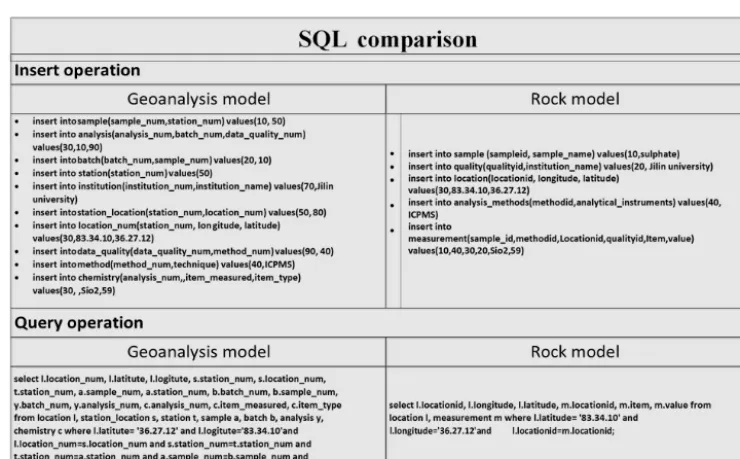
Figure 6.Comparison of insert and query operations in structured query languages (SQLs).
Figure 4 shows the LDM scheme designed for geoanalytical data. Each box in the LDM represents an object, and items in the box are its attributes. The relations between object are represented with lines. There are three kinds of symbols asso-ciated with the lines. The short line denotes “1”, the circle de-notes “0” (which means “maybe”), and the triangle dede-notes “many”. Lines and symbols define the relations between ob-jects. The additional notation foreign key (FK) is added if the attribute in one object uniquely identifies an attribute in another object. For example, the sample ID in the geoana-lytical data object is a foreign key of “sampleid” in the sam-ple object, because they have the same value. By means of this foreign key, the data contents of the two objects are con-nected. For each object, a few extended attributes are added
(Extend_nin Fig. 4). This feature allows developers to add database-specific attributes to this model, increasing its flex-ibility and universal applicability.
3 Implementation and evaluation
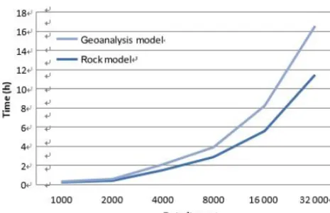
Figure 7. Time spent on data insert operations with increasing amounts of data.
Figure 8. Time requirement for data queries (latitude and longi-tude).
was adopted to implement the two models. A specific data item (rock type: andesite; location: Sycamore Hall; latitude: 36.27.12◦N, longitude: 83.34.12◦W; institution: Jilin Uni-versity; method: ICP-MS; SiO2:58.9; FiO2:1.13) was used as test data and tables related to the data contents were im-plemented. We analyzed the two models from two perspec-tives: developers and users. For developers, the comparison of the PDM structure is shown in Fig. 5, and query op-eration descriptions are presented Fig. 6. The comparison clearly indicates that the geoanalytical data model is more succinct than rock data model and saves time and computer resources. Three model performance indicators (insert time, storage space usage, and retrieval time) were evaluated with the increasing of amounts of data. The results are shown in Figs. 7, 8, and 9, respectively. Figure 7 shows clearly that the process of data insertion is considerably faster for the geoanalytical data model when compared to the rock data model. Figure 9 shows clearly that the storage space usage is relatively less than rock data model. In the case of data query (Fig. 8), the difference in time consumption is even more striking. With an increasing amount of data items, the query time of the geoanalytical data model remains very fast
Figure 9.Space usages of the two data models with increasing amount of data items.
and efficient. In contrast, for the rock data model, query time costs increased exponentially with the increasing amount of data items.
4 Conclusions
The geoanalytical data model presented herein is flexible and appropriate for a broad range of applications to geoanalytical data. The model has the following general characteristics:
1. Its universality allows the model to accommodate any type of geoanalytical data for various geological mate-rials, as well as all significant metadata.
2. The adoption of a multi-dimensional data model frame-work provides geological researchers with the ability to analyze geoanalytical data from different dimensions. In addition to the sample description and location cri-teria commonly used in existed databases, this model provides four additional query criteria (method, quality, time, and analysis).
3. There are minimum data relations between different ob-jects. Relations between different background metadata objects have been avoided in order to construct robust relations between background metadata and measure-ment data. This increases the model’s efficiency when geoanalytical data are inserted or queried while simul-taneously decreasing its space usage.
Data availability. Data in this paper were used to test the efficiency of data insert operations, data query operations, and space usage. The core factor of the data is the amount of data but not the content of the data. The specific data in this paper are cited from an experi-mental result of the authors. The amount of data created was based on a specific item through the program. Users could take advantage of any data to test the experiment and the result will be the same.
Author contributions. YTH and DT conceived and designed the study. YTH performed the experiments and wrote the paper. HW reviewed and edited the paper. LY provided many suggestions about the concept model. MY and PC reviewed and edited the paper. All authors read and approved the paper.
Competing interests. The authors declare that they have no conflict of interest.
Acknowledgements. We would like to thank two anonymous re-viewers for their suggestions and comments that contributed to im-proving the article.
Financial support. This research has been supported by the High-Level Talent Scientific Research Starts Fund Project (grant no. 419YKQN11) and National Major Scientific Instruments and Equipment Development 5 Special Funds (grant nos. 2016YFF0103303, 2011YQ050069).
Review statement. This paper was edited by Mark Paton and re-viewed by two anonymous referees.
References
Adcock, S., Grunsky, E., and Laframboise, R.: A Uni-versal Geochemical Survey Data Model, available at: https://www.researchgate.net/publication/266066484_A_ Universal_Geochemical_Survey_Data_Model, last access: 1 October, 2019.
Artioli, G., Angelini, I., Nimis, P., and Villa, I. M.: A lead-isotope database of copper ores from the Southeastern Alps: A tool for the investigation of prehistoric copper metallurgy[J], J. Archaeol. Sci., 75, 27–39, https://doi.org/10.1016/j.jas.2016.09.005, 2016. Beynon-Davies, P.: Relational Data Model, in: Database Sys-tems, Palgrave, London, https://doi.org/10.1007/978-0-230-00107-7_7, 2004.
Brandl, P. A., Regelous, M., Beier, C., and Haase, K. M.: High mantle temperatures following rifting caused by continental insulation, Nat. Geosci., 6, 391–394, https://doi.org/10.1038/ngeo1758, 2013.
Carbotte, S. M., Marjanovi´c, M., Carton, H., Mutter, J. C., Canales, J. P., Nedimovi´c, M. R., Han, S., and Perfit, M. R.: Fine-scale segmentation of the crustal magma reservoir
beneath the East Pacific Rise, Nat. Geosci., 6, 866–870, https://doi.org/10.1038/ngeo1933, 2013.
Carbotte, S. M., Marjanovi´c, M., Carton, H., Mutter, J. C., Canales, J. P., Nedimovi´c, M. R., Han, S., and Perfit, M. R.: Fine-scale segmentation of the crustal magma reservoir beneath the East Pacific Rise, Nat. Geosci., 6, 866–870, https://doi.org/10.1038/ngeo1933, 2013.
Carr, M. J., Feigenson, M. D., Bolge, L. L., Walker, J. A., and Gazel, E.: RU_CAGeochem, a database and sample repository for Cen-tral American volcanic rocks at Rutgers University[J], Geosci. Data J., 1, 43–48, https://doi.org/10.1002/gdj3.10, 2015. Cheng, H., Zhou, H., Yang, Q., Zhang, L., Ji, F., and Henry, D.:
Jurassic zircons from the Southwest Indian Ridge, Sci. Rep, 6, 26260, https://doi.org/10.1038/srep26260, 2016.
Chmura, A. and Heumann, J. M.: Logical Data Modeling, Inte-grated, 5, 179–203, https://doi.org/10.1007/b100064, 2005. Cottrell, E. and Kelley, K. A.: Redox heterogeneity in mid-ocean
ridge basalts as a function of mantle source, Science, 340, 1314, https://doi.org/10.1126/science.1233299, 2013.
Dick, H. J. B. and Zhou, H.: Ocean rises are products of vari-able mantle composition, temperature and focused melting, Nat. Geosci., 8, 68–74, https://doi.org/10.1038/ngeo2318 , 2014. Evans, A., France, R., Lano, K., and Rumpe, B.: The UML as a
Formal Modeling Notation, Comput. Stand. Interf., 19, 325–334, https://doi.org/10.1016/s0920-5489(98)00020-8, 1998.
Evans, A., France, R., Lano, K., Francea, R., Evansb, A., Lanoc, K., and Rumped, B.: The UML as a Formal Modeling Notation[J], Comput. Stand. Interf., 19, 325–334, https://doi.org/10.1007/978-3-540-48480-6_26, 2014.
Greber, N. D., Dauphas, N., Bekker, A., Ptáˇcek, M. P., Bindeman, I. N., and Hofmann, A.: Titanium isotopic evidence for felsic crust and plate tectonics 3.5 billion years ago, Science, 357, 1271– 1274, https://doi.org/10.1126/science.aan8086, 2017.
Hellström, F.: The Swedish bedrock age database, https://doi.org/10.13140/RG.2.1.1528.8085, 2016.
Helo, C., Longpré, M. A., Shimizu, N., Clague, D. A., and Stix, J.: Explosive eruptions at mid -ocean ridges driven by CO2-rich magmas, Nat. Geosci., 4, 260–263, https://doi.org/10.1038/ngeo1104, 2011.
Hoberman, S.: Data Modeling Essentials, 3rd, The Morgan Kauf-mann Series in Data Management Systems ,Morgan KaufKauf-mann Publishers Inc. San Francisco, CA, USA, 560, available at: https://dl.acm.org/citation.cfm?id=1211351 (last access: 1 Octo-ber 2019), 2005.
Hoernle, K., Hauff, F., Werner, R., Bogaard, P. V. D., Gibbons, A. D., Conrad, S., and Müller, R. D.: Ori-gin of Indian Ocean Seamount Province by shallow recy-cling of continental lithosphere, Nat. Geosci., 4, 883–887, https://doi.org/10.1038/ngeo1331, 2011.
Höpken, W., Fuchs, M., Höll, G., Keil, D., and Lexhagen, M.: Multi-Dimensional Data Modelling for a Tourism Destina-tion Data Warehouse, https://doi.org/10.1007/978-3-642-36309-2_14, 2013.
reduc-for rocks, Geochem. Geophys. Geosyst., 1, 179–188, https://doi.org/10.1029/1999gc000026, 2000.
Linge, K. L., Bédard, L. P., Bugoi, R., Enzweiler, J., Jochum, K. P., Kilian, R., Liu, J., Marin-Carbonne, J., Merchel, S., and Munnik, F.: GGR Biennial Critical Review: Analytical Devel-opments Since 2014, Geostand. Geoanal. Res., 36, 337–398, https://doi.org/10.1111/ggr.12200, 2017.
Lopes, C., Ferreira, A., Chichorro, M. A., Pereira, M. F. C., Almeida, J. A., and Solá, A. R.: Chroniberia: The Ongo-ing Development of a Geochronological GIS Database of Iberia[J], Strati, 2013, https://doi.org/10.1007/978-3-319-04364-7_138, 2014.
Champion, D.: A new database compilation of whole-rock chem-ical and geochronologchem-ical data of igneous rocks in Queensland: a new resource for HDR geothermal resource exploration[C], in: Proceedings of the 2011 Australian Geothermal Energy Confer-ence, editedy by: Rudd, A., Geoscience Australia, Sydney, 239– 244, 2012.
Straub, S. M., Goldstein, S. L., Class, C., and Schmidt, A.: Mid-ocean-ridge basalt of Indian type in the north-west Pacific Ocean basin, Nat. Geosci., 2, 286–289, https://doi.org/10.1038/ngeo471, 2009.