CALAR: Community Aware Location Assisted
Routing Framework for Delay Tolerant Network
Sweta Jain
1, Vinuraj.R
21, 2 Department of Computer Science and engineering, National Institute of Technology, Bhopal, India
Abstract: Infrastructure less communication strategies have
greatly evolved and found its way to most of our real life applications like sensor networks, terrestrial communications, military communications etc. The communication pattern for all these scenarios being identical i.e. encounter based communication; characteristics of each communication domain are distinct. Hence the protocols applied for each environment should be defined carefully by considering its own communication patterns. While designing a routing protocol the main aspects under consideration include delay, connectivity, cost etc. In case of applications having limited connectivity, concept of Delay tolerant network (DTN) is deployed, which assists delivering messages even in partitioned networks with limited connectivity by using store and forward mechanism. Node properties like contact duration, inter contact duration, location, community, direction of movement, angle of contact etc. may be used for designing different routing protocols for DTN. This paper introduces a new protocol that exploits the features of both community based as well as location based routing protocols to achieve higher data delivery ratio in vehicular scenarios. Simulation results obtained show that proposed algorithms have improved delivery ratio compared to existing routing algorithms which use any one of the above property individually.
Keywords—DTN; VANET; Location based; Community based.
1.
Introduction
DTN contains ad-hoc nodes forwarding data through opportunistic contacts [1]. Owing to the sparse network and dynamic nodes, an end-end path communication mode does not exist in DTN. Infrastructure less mode of communication in DTN has its own advantages in areas where setting up a backbone network is tedious and extravagant.
In DTN, nodes may suffer from long delays due to the frequent disconnections and partition of the network. In order to establish reliable communication under above discussed impediments, DTN uses store and forward mechanism for message forwarding [2], [3]. Even though this is the only existing and possible method of communication in DTN, it should be optimized in order to achieve high delivery ratio by adopting proper routing protocols.
Different routing strategies belonging to different class of routing were widely used for message transmission in DTN until concepts of social networks took its attention. Since DTN serves human society, exploiting the social behavior of communicating nodes can facilitate improved data delivery in such networks [4]. So far location based social information i.e. geographical co-ordinates distance between nodes etc. [5] [6] and encounter based social information i.e. contacts of individuals, social similarity, social centrality etc. [7] [8] [9] were widely studied for designing new protocols. Besides
social characteristics, community is also important while developing routing protocols because the nodes from same community may have identical movement and communication patterns compared to nodes belonging to different communities. This property helps a message carrier to find more apt relay to reach destination.
Each class of routing protocol for DTN has its own limitations. For e.g. location based routing forwards data to a node which is geographically closer to destination. Since contact pattern and mobility patterns are not considered, they may select inefficient routing paths and hence can't guarantee optimal delivery ratio. Similarly encounter based protocols logically try to choose best relay nodes using history of encounters. Even though it may provide improved delivery ratio, looping of packets or long delays can occur in these protocols since location information is not taken into account for routing. In community based protocols, routing across the communities faces difficulties because of weak communication opportunity between inter community nodes. In order to overcome the limitations of above mentioned routing classes namely location based and community based, protocols should be defined over multiple matrices. This paper proposes a new routing protocol which incorporates essence of most of the above discussed strategies. Community structure, location information such as coordinates of nodes, distance between nodes, and mobility pattern like movement vector, velocity of nodes have been selectively encapsulated to provide much better delivery opportunities.
Proposed work contributes a routing strategy that can be used in both DTN as well as in Non-DTN environments. This protocol may be of great use in Vehicular Ad-Hoc Networks (VANET) environment, where all the nodes are under continuous motion, due to its ability to combine mobility information with community structure.
The paper is organized as follows. Section II describes about the main concepts of location based and community based routing as well as a brief description of related works. Section III throws light on the proposed strategy and its algorithms. Obtained results based on three different scenarios will be discussed in section IV and section V concludes the paper with a brief description about potential future work.
2.
Related Works
node in the network should be equipped with a GPS device in order to track its position.
Routing based on location information can be classified mainly into two categories: (1) geographical distance based, and (2) mobility pattern based.
In [43], the authors have classified and compared DTN based and non-DTN based geographic routing protocols for VANETS and have suggested when each of the approaches are suitable in vehicular network scenario. For instance, some network applications require faster transmission even though they may tolerate packet loss to a certain extent, in such situations non- DTN geographical-based routing protocols may be used. While some applications require assured delivery but can tolerate delay in packet transmissions, and hence DTN based geographical based routing protocols may be useful in such cases. A hybrid approach whereby one may exploit advantages of both the approaches and improve transmission performance is also possible. DTN based approaches make sure that the packet reaches its destination even if there is some delay, while non-DTN based routing protocols exploit storage and speed of nodes to ensure timely delivery of packets.
Routing protocols based on geographical distance use distance between a node and destination as a metric to forward data, where geographical distance is the distance measured along the surface of the earth. Some of the popular routing protocols in this category are discussed below. In Greedy Perimeter Stateless Routing (GPSR) [13], the neighbor’s position obtained through information exchange procedure will be used to define a greedy strategy which locally chooses the next hop geographically closer to destination. At local maxima (if no candidate node exists in that region which is closer to destination) GPSR uses the right hand rule which includes traversing the interior of a closed polygonal region in clockwise direction to identify the next hop. This is known as routing around the perimeter region. GPSR requires a planar graph constructed from the network model for its proper working.
The Greedy Perimeter Coordinator Routing (GPCR) [14] also requires a planar graph for its operation. GPCR identifies streets and junctions from this planar graph and restricts the greedy forwarding phase by transferring data to nodes at junctions only. These junction nodes will choose more appropriate neighbor nodes to reach the destination. As a repair strategy at local maxima, GPCR also uses perimeter routing strategy as in GPSR. The assumption of always finding a node at junctions makes the protocol impractical at some point of time.
Mobility-Centric Data Dissemination Algorithm for Vehicle Network (MDDV) [15] also follows above discussed strategy. With the use of a GPS system it identifies a candidate relay node which is closer to destination region. It lags behind since there is no route recovery mechanism proposed in this work neither is it equipped with any recovery strategy when the geographic routing is not applicable.
Use of navigation system in GeOpps [16] detects the nodes which may move closer to destination. Calculation of the time required to travel through the shortest path from next point in movement direction to destination will help to find the more appropriate neighbor to forward the message. This strategy is repeated until the data is delivered to the
destination. The requirement to estimate arrival time to even geographically far nodes needs global view of the network and makes the protocol difficult to be implemented in DTN's. Three different modes of data forwarding are introduced in the hybrid routing strategy GeoDTN+Nav [17] namely a greedy mode, a perimeter mode and a DTN mode. Greedy mode and perimeter mode work exactly similar to the working strategy of GPSR and GPCR. When the network becomes sparse, protocol changes its mode of routing into DTN mode to get the benefit of custody transfer. Switching between non-DTN mode and DTN mode is determined by network connectivity which mainly depends upon neighbor’s direction to the destination, neighbor’s delivery quality and the number of hops a packet has traveled.
A location-based overlay for DTN's was proposed by Locus [18]. This protocol keeps the data in a specific area with the help of neighbor devices. The region where the data should belong to is termed as home region and the node which is geographically closer to data's home region is selected as the next hop in data forwarding. But this strategy triggers only if some nodes are there in the home region of data and it requires multiples copies of a data as well.
Study of different protocols under location based routing strategy reveals that most of them depend heavily on geographical distance between the nodes and purely work as greedy algorithm. But when greedy mode fails they introduce some repair strategy which mostly includes brute force approaches to overcome the packet losses.
While establishing communication and navigation systems, we need the live movement information of the user so as to keep the routing in synchronization with the movement of the user in a timely manner. The above mentioned goal can be accomplished by retrieving the movement related information that includes the path already covered by the user and the possible paths that can be undertaken. For this purpose some models are used to facsimile the movement information and are called MOBILITY models. While framing the utility measure, the frequencies with which the nodes meet also need to be considered.
A routing technique called MV Routing [19] uses the node meeting frequency factor. It defines “home community” where the nodes passed by or stayed close to, most frequently and then selects a node having higher utility value for home community as the relay node. This technique facilitates the forwarding of data even to a stationary node. As in the case of stationary nodes, the meeting frequency cannot be determined, the visits to these stationary nodes are taken as a base factor.
Some routing algorithms like VeRo [20] and MoVe [21] use movement vector as the basis to finalize the resultant trajectory. Nodes in VeRo stress upon the locations and angle of changes and forwards packet if the candidate node is going away from it. But MoVe considers the information like velocity and direction to retrieve the shortest possible path between the node encountered and the destination. This information can be collected by exchanging the trajectory information.
One of the possible additives can be the change of degree of node and the mentioned merger is used as it is in CAR [22]. In order to calculate the node trajectory, the Euclidean distance can be considered as a major factor. The node having lesser value of distance from the destination node can be used as the next stop. “Mobyspace” [23] uses the similar technique to establish the source to destination path for delivery of message. In order to calculate the Euclidean distance, the vector includes two important values: the nodes that have already been covered and the amount of time spent at each of them.
A generic Geographical Heuristic Routing (GHR) protocol has been proposed in [44] that can be applied to any DTN geographical routing protocol for taking hop-by-hop forwarding decisions. It adapts simulated annealing and Tabu-search meta-heuristics in VANET routing protocols for taking optimal routing decisions in contrast to greedy decisions taken in most of the VANET routing protocols. In [45], a secure geographic routing protocol called PrivHab has been proposed which makes use of cryptographic techniques to preserve nodes’ privacy. It learns the moving and visiting pattern of the nodes and then selects the best relay node for message forwarding.
In [46], each node builds an inter-contact graph of the nodes to which it contacts and the weights of the links are assigned based on average delay and variance of the delay between two node encounters. This information is used in multi-copy routing protocol for copy- distribution and for taking forwarding decision.
A wide variety of Location based strategies are also used for underwater wireless sensor networks some of which are for delay tolerant applications and some for non delay tolerant applications [42].
DTNs have routing strategies greatly inspired by communication patterns of the humans in the society. The society can be further subdivided into various communities such that inter community communication is a bit strenuous but intra community communication is ultra-fast and easy to handle..
Label Routing, proposed by Hui and Crowcroft [24] uses the social structure to identify the path from source to destination. The name “Label” signifies that a label is associated with each person in a community. Whenever two people meet the labels are identified and the message is transferred to the node closer to the destination community. The process repeats until the message is delivered to the defined destination. Thus here people are used as conveyor for the node related information which can be exchanged when two people meet. This is an example of Pocket Switched Networks (PSNs) [25].
An enhancement to Label was devised by Hui et.al. in a routing protocol called Bubble Rap which uses K-clique based flow of data [26]. In addition to social communities as in the case of Label Routing, social relationships are also utilized in this routing protocol. Each node has two factors associated with it the global social centrality (defined in terms of inter community communication) and the local social centrality (defined in terms of intra community communication). The data transfer from source to destination occurs in two phases. The first phase includes the transfer of data from the source node community to the community containing the destination node which is based on
comparison of global social centrality measure of nodes encountered. The second phase includes the data transfer to the specified node within the destination community and this flow is based on the comparison of local social centrality measure of the nodes encountered until the message reaches its destination.
The data forwarding can even be extended to multicasting using the above mentioned features i.e. social centrality and social community structure. A method incorporating this was proposed by Gao et. al. [27] which uses the social centrality feature in case of single data multicasting and considers even the latter feature for multiple data multicasting. In each of the scenarios, the node with the highest respective value is fixed as the next hop. The delivery probability of nodes is the key measure when the structural part is considered i.e. in multiple data multicasting.
LocalCom [28] is a method proposed to identify the social community structure. The sum of degree of a node and its neighbors is considered as a factor to divide the nodes into communities. A high value of this sum signifies that the nodes should belong to the same community. Following this algorithm, the message is directly forwarded to the destination in a single hop which is based on the hop count distance within the community. If the message is to be forwarded from one community to another, bridges are used. As the first step, the data is forwarded to the bridge in a fashion similar to data forwarding within a community. The selection of best suited bridge is done by pre pruning mechanism. The data is then further transferred on the basis of dynamic information. Thus the inter community data transfer includes pre pruning; to identify the best bridge and data transfer based on dynamic information.
Another measure that can be used to classify nodes into communities can be the transfer delay between the nodes. The nodes having shorter delay can be grouped into a single community. Considering such nodes as friends, an algorithm was proposed called Friendship Based Routing (FBR) [29]. Since the basis of classification is the time delay to transfer, this mechanism holds different communities having a wide variety of delay periods. If we want to transfer a message within a community, the message is sprayed to many nodes belonging to the same community. In case of message to be delivered to some other community, the hop selections are concerned with time. The data can be forwarded to next community only if the transfer delay of the two communicating communities is comparable. Thus a sequence of hops is formed based on the delay and the message is finally handed over to the destination.
Another routing algorithm based on social community structure is known as the Homing Spread Routing Algorithm [30]. It considers the locations that are shared and visited by people with some common motives as “Community Homes”. These community homes are the first to get the data to be forwarded. From here the data can be forwarded to users which can eventually fork out the data to the destination when encountered.
The nodes having highest centrality values are considered to be the community homes. Each of these nodes identifies the best suitable path towards the destination based on the transfer delay. Once the forwarding routes are finalized, the data is forwarded by each of the community homes. The process is continued until the data reaches the destination home.
Another social based algorithm was proposed by Abdelkedar et al. called SGBR [32] which forms social groups node contact frequency with each other rather than with all nodes in the network in the past. Thus this algorithm surpasses the above mentioned community based routing algorithms in the sense that it works only on local information and does not require network wide information each time.
Another forwarding proposal called CiPRO [33] uses the meeting probability of the given nodes in a certain span of time. Hence a message is forwarded to another node only if the meeting probability of that node with the destination is higher than the meeting probability of the current node. Thus in order to optimize the forwarding efficiency, a database of the meeting probabilities of nodes is maintained so as to predict the best possible route from source to destination. An example of similar methodology is presented in a scheme called SocialCast [34] which envisages the interest that the nodes share with each other. The utility measure of nodes is calculated on the basis of the data interest shared among nodes. Thus based on this measure the utility of a given node can be estimated over some given interest. Hence along with the messages the users need to define even the interest so that the most preferable path can be articulated.
ContentPlace [35] is an algorithm that takes into account the cost to access the required object and the interactions of a given user with other users of same or different community. On these measures, a function is calculated and the best data object for a given user interest is extracted. These objects can then be forwarded to all the communities that have strong interactions with the user.
There have been some algorithms proposed that rectify the limitation of overlooking the dynamic nature of users in the social community structure. An example in this league is dLife [36]. It considers the variable values of frequency and duration of interactions among different users at different periods of time. It keeps track of time spans when the interactions are at the peak and the data is forwarded correspondingly.
There is a class of algorithms that takes into account the social structure and data interest along with the dynamic mobility of users among communities or within. SCORP [37] is one such algorithm which stresses upon the data interest of a given node along with the interests of the nodes that have previously been encountered. The message is forwarded to nodes having the same interest as the type of the message that is being forwarded. It considers the common data interest shared by the users.
However, community formation based on social information is different from cluster formation in networks whose main purpose is to improve data delivery in large-scale networks. In [41], a hierarchical routing protocol for DTNs is proposed which is based on optimal selection of cluster head and uses multiple message ferries for inter cluster communication. The cluster head election is based on the residual energy, the
intra-cluster distance, the node degree and the headcount of probable CHs.
Thus after a brief review of the different community based algorithms, it may be concluded that the real time social structure can be very well used to inspire the actual routing algorithms to work efficiently. These algorithms are still rigid when implemented and have a great scope for further amendments. These algorithms also lag behind in terms of utilizing the mobility pattern of nodes. Since the actual users are mobile and dynamic, hence further advanced techniques to continuously monitor the movements and interactions need to be incorporated to obtain the optimal results.
3.
Proposed Work
In DREAM [38], authors proposed mobility based routing scheme, where the source node logically consider an arc of theta degree in the direction of destination and forwards the message to a node residing in that arc. While designing the protocol the angle theta is chosen in such a way that by the time the relay mode reaches the destination, it will still be inside that arc. This process repeats until the message reaches destination. But this architecture does not consider the coverage area of individual nodes. If coverage area is very less, there may be a possibility that by the time relay node reaches the destination, destination may reside in the arc but not essentially in contact range.
To design CALAR, the forwarding metric takes into account the arc in the movement of direction in combination with the community structure. K clique Community detection algorithm is used for identifying distributed as well as overlapping community patterns in the network. Since CALAR considers location as well as community information; protocol is able to overcome the disadvantages of both the categories such as looping, inter community routing etc. Consideration of location based information makes the protocol more suitable for vehicular environment. A. It is assumed that the formed communities maybe overlapping in nature and e ach node is equipped with a GPS device so as to keep track of its location in the network. The communicating nodes in the given network environment are primarily partitioned into overlapping communities using K-clique community detection algorithm on a predefined threshold value. When two nodes meet each other, the message transferring decision has to be taken by considering the following cases:
Suppose node ‘A’ wants to deliver a message to destination node ‘D’ and node ‘A’ meets node ‘B’. The below mentioned scenarios may occur.
Case I:
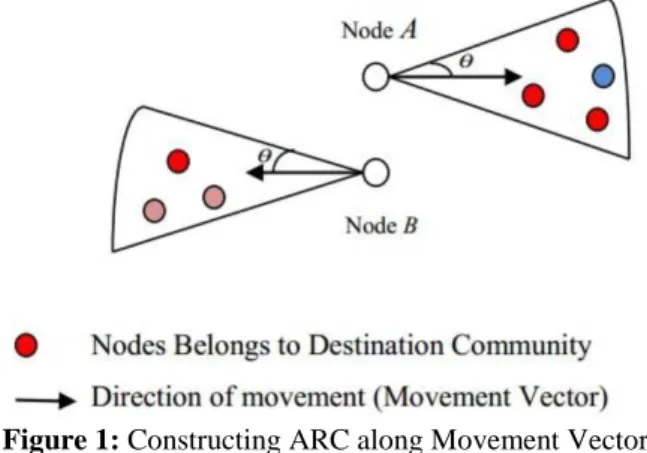
If ‘A’ and ‘B’ belong to different communities as that of ‘D’: Here both ‘A’ and ‘B’ will consider an Arc of 2ө in their direction of movement as shown in Figure 1 and count the number of nodes belonging to destination community inside that arc. If node ‘B’ has a node count greater than node ‘A’, then it will forward the message to ‘B’.
The value of ө should be selected carefully such that by the
checking the density of destination community nodes inside the arc always guarantees that the message will forwarded to a relay node having more chances to meet the destination community nodes.
Figure 1: Constructing ARC along Movement Vector
Both ‘A’ and ‘B’ having no such node indicates that both are away from the destination community. Hence it needs to be checked whether ‘B’ is in the direction of ‘D’. If yes, forward the message to ‘B’. If ‘A’ also moves in the direction of ‘D’ (‘A’ and ‘B’ in the same direction) then replicate the message copy.
Case II:
If node ‘A’ belongs to Destination Community but ‘B’ doesn’t:
Since ‘A’ and ‘D’ belongs to same community there is a higher probability to meet ‘D’ nearby. But to check whether ‘A’ is away from its home community, consider the arcs as in case 1. If ‘A’ has less number of nodes belonging to destination community in its arc as compared to ‘B’, it’s probable that ‘A’ is away from its home community and ‘B’ is going towards destination community. In this case forward the message copy to ‘B’. If ‘A’ is having higher number of such nodes in its arc than ‘B’, then do not forward, since it implies that ‘A’ is closer to destination community.
If both ‘A’ and ‘B’ have nearly equal number of nodes belonging to destination community in their arcs, it is clear that ‘A’ is in home community, both ‘A’ and ‘B’ are close to destination. Now check whether ‘B’ is moving towards the destination. If yes, replicate the message. Since ‘A’ already belongs to D’s community, to reduce overhead ratio replicate only if ‘A’ is away from ‘D’ and ‘B’ is moving towards ‘D’. If both ‘A’ and ‘B’ have less number (nearly zero) of nodes belonging to destination community in their arc, then both nodes may be away from D’s community. By considering the fact that ‘A’ may soon return to its home community, it will not forward the message copy to ‘B’.
Case III:
If ‘B’ and ‘D’ belongs to same community but ‘A’ doesn’t: Since ‘A’ met ‘B’, most probably ‘A’ is in D’s home community. So check whether ‘A’ is moving away or towards the destination. If moving away then forward the copy to ‘B’, else replicate the copy only if ‘B’ is moving towards ‘D’. Even if ‘A’ and ‘B’ meet outside the home community of ‘D’ the above rule is applicable.
Case IV:
If ‘A’, ‘B’ and ‘D’ belong to same community:
Here the probability is high for all the three nodes being near their home community. If not, either ‘A’ and ‘B’ are
away or ‘D’ is. In this case check which nodes move towards ‘D’. If both move towards ‘D’ then replicate the copy. If only
B is moving towards ‘D’ then forward the message. If only
‘A’ is moving then forwarding is not required. Finally if both ‘A’ and ‘B’ move away from ‘D’ then check which one has higher probability to meet more number of nodes belonging to destination community by constructing the arc and forward message to ‘B’, if it is the one.
Algorithm to identify meeting probability of tqo nodes using their movement vectors:
Figures 2-5 show the different movement patterns of a node with respect to a destination node. The algorithm to identify the meeting probability of two nodes using movement vectors and their angle of inclination needs to consider the following cases:
Case I:
Figure 2: Nodes moving parallel
Suppose movement vectors of node ‘A’ and node ‘D’ are parallel (angle between and is same as that of angle between and as shown in Figure 2), then the vertical distance between their movement vectors needs to checked. If it is less than the sum of their coverage range, then in near future they will contact and the messages can be delivered from node A to destination node D. The case where vertical distance between their vectors is more than sum of their coverage area then node A is ignored as a relay as there is very less probability that node ‘A’ and ‘D’ will come in contact.
Case II: If node ‘A’ and ‘D’ move in opposite direction such that their movement vectors are anti-parallel (if the angle between and is ө then angle between and will be
180-ө as shown in Figure 3), then it needs to be checked whether nodes have already crossed each other or not (if ө is less than 90 degree then this denotes that nodes have not crossed each other).
Figure 3: Nodes moving Anti Parallel
greater than their combined coverage range then there is a negligible chance that the two nodes will meet each other. Case III: If movement vectors of nodes ‘A’ and ‘D’ are skew vectors (not parallel and anti-parallel), then check whether they move in the same direction or in opposite direction (if the angle between and is greater than or equal to 90 degree then they are moving in opposite direction as shown in Figure 4). Nodes moving in opposite direction certainly signify minimum chance of meeting between the two nodes.
Figure 4: Skew movement vectors in opposite direction
(Converging vectors) (Diverging vectors)
Figure 5: Skew movement vectors in same direction
On the other hand, if the nodes move in the same direction as shown in Figure 5, then we need to check whether their movement vectors are converging or diverging. This may be done by calculating the difference between and at the current locations of node ‘A’ and ‘D’ and at the next locations. If the difference is incrementing then movement vectors are diverging else converging. If the movement vectors are diverging then node ‘A’ is going away from node ‘D’ and there are rare chances for their contact. But if movement vectors are converging then there is a high probability that the two nodes meet.
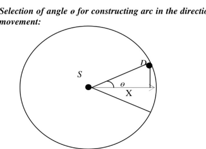
Selection of angle ө for constructing arc in the direction of movement:
Figure 6: Construction of ARC in the direction of Movement
with optimum ө
Suppose ‘D’ is the node staying at the extreme end of node
S’s coverage area (inside the arc). If ‘D’ is stationary, ‘S’
needs to travel X distance to come vertical to node ‘D’ (to make an encounter) as shown in Figure 6. Since nodes ‘D’ is not stationary, while ‘S’ travels X distance, ‘D’ travels X1 distance (may be ‘D’ is moving away from previous location and assuming both nodes have same coverage area). Hence even after ‘D’ travels this X1 distance, nodes must stay in each other’s proximity.
R – X1 > 0 …. (1)
Here R denotes the communication range of nodes.
The X1 distance covered by ‘D’ should lie inside coverage area of ‘S’ (Assuming ‘S’ also traveled X distance).
X = R × cos (ө) .… (2) Time T taken by node ‘S’ to cover distance X at speed v1 = X/v1
Distance X1 travelled by node ‘D’ at speed v2 in T time X1 = v2 × T
= v2 ×(X/v1) X1 = (v2/v1) × X
Replacing X by equation (2) X1 = (v2/v1) × R× cos (ө) …. (3)
Hence equation (1) now becomes:
R – (v2/v1) × R × cos (ө) > 0 …. (4) For getting a guaranteed contact, there should be a minimum
overlap between communication ranges of ‘S’ and ‘D’. Hence, R – (v2/v1) × R × cos (ө) > 1 …. (5) If v2 < v1 then node ‘D’ will always be in the coverage range of node ‘S’, hence one needs to consider the case where v2 > v1.
Since we cannot predict the exact node and its velocity which comes at the extreme end of arc, let us assume that v2 = 2 × v1
Then, 1 – 2 × cos (ө) > (1/R) .... (6) The minimum value of ө satisfying equation 6 will give optimal results.
4. Result Analysis
The performance of the proposed protocol has been evaluated in multiple scenarios generated with the help of ONE simulator [39]. ONE is a java based simulator; where new protocols for DTN can be executed with self-defined scenarios and network parameters. Two vehicular environment scenarios as well as a DTN scenario with default parameters were considered.
4.1 Map Based Movement Model
The first scenario considered is a basic scenario consisting of group of all kind of nodes such as Pedestrians, Cars, and Trams. This is the default settings using in the ONE Simulator. The details of this scenario are given in Table 1 and the properties of each group of nodes are listed in Table 2. A simple map-based movement model is used in the Helsinki City Scenario where trams follow predefined routes. Here two thirds of the remaining nodes are pedestrians and one third is cars. The pedestrians and cars choose random destinations in their route on the map and move there following the shortest path.
Simulations for this configuration were run for a 24 hour time period and the simulation results obtained are shown in Figures 7-10. Performance of CALAR has been compared with two related class of routing protocols, Social based and Location based. The DLife and BubbleRap are two state of
ө
S
X
art social based routing protocols for DTNs. The graph in Figure 7 shows the variation in delivery ratio with varying values of TTL of messages. Message TTL determines the life time of a message in the network before it is removed permanently. As compared to community based routing protocols, CALAR achieved a 78% increase in delivery ratio with a less average latency.
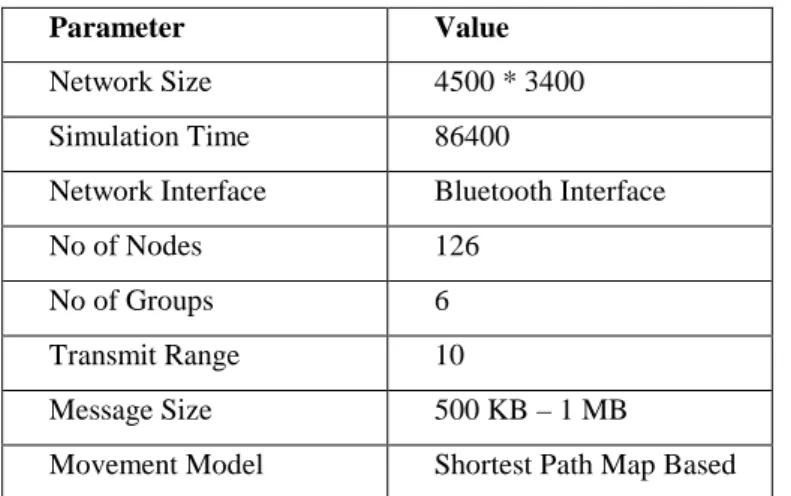
Table 1: Map Based Movement Model
Parameter Value
Network Size 4500 * 3400
Simulation Time 86400
Network Interface Bluetooth Interface
No of Nodes 126
No of Groups 6
Transmit Range 10
Message Size 500 KB – 1 MB
Movement Model Shortest Path Map Based
Table 2: DTN Group Specifications for Map Based
Movement Model
Group Interfaces No. of
Hosts
Speed
1 BT 40 0.5 – 1.5
2 BT 40 2.7 – 13.9
3 BT 40 7 – 10
4 BT 2 7 – 10
5 BT 2 7 – 10
6 BT 2 7 – 10
BT: Bluetooth Transmission HT: High Speed Transmission
Figure 7: Delivery Ratio vs. TTL of CALAR and
Community based routing protocols in Map based movement model scenario.
CALAR is able to achieve such high delivery ratio than other two community based routing protocols, because it considers location information as well as movement direction of nodes while forwarding message copies rather than using a single community metric. Dlife and BubbleRap show similar performance trends due to their common working strategy that solely depends on the community structure with respect to the node movement [40].
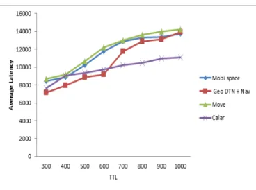
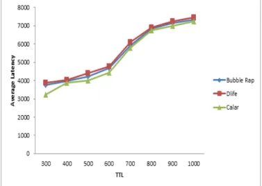
Figure 8 shows the average latency required to deliver a message to its destination. Ability to forward a message to nodes or nodes having more number of neighbors which move in the direction of destination helps CALAR to achieve better delivery performance with lower average latency as compared to other two compared routing protocols namely dLife and BubbleRap.
Figure 8: Average Latency vs. message TTL of CALAR and
Community based routing protocols in Map based movement model scenario.
Figure 9: Delivery Ratio vs. message TTL of CALAR
and location based routing protocols in Map based movement scenario.
Since community structure plays a vital role, this information when combined with location information, results in more effective selection of relay nodes in the routing process of CALAR and hence it obtains better results as compared to other protocols. This also helps in reducing the average latency of message delivery which can be seen from simulation results shown in Figure 10.
Figure 10: Average Latency vs. message TTL of CALAR
and location based routing protocols in Map based movement scenario.
4.2 Working Day Movement (WDM)Model
This is a more practical hybrid setting which consists of nodes following both vehicular and human mobility. This scenario uses Bus movement, working day movement and map based movements as the mobility patterns. WDM is an enhanced movement model which brings more reality to the node movement by modeling three major activities typically performed by humans during a working week first is sleeping at home, second is working at the office, and third is going out with friends in the evening. These three activities are divided into corresponding sub-models between which the simulated nodes transition, depending on the time of the day. There are total 17 groups of nodes and properties of each of the groups are listed in Table 4.
Table 3: Working Day Movement Model
Parameter Value
Network Size 10000 * 8000
Simulation Time 86400
Network Interface
Bluetooth Interface
No of Nodes 150
No of Groups 17
Transmit Range 10
Message Size 500 KB – 1 MB
No of Offices 50
Work Day Length 28800
Table 4: Group Specifications of Settings II
Group Movement
Model
Speed No. of
Hosts
1,3,5,7,9,11,13,15 Bus Movement 7 – 10 2 2,4,6,8,10 Bus Movement 0.8 – 1.4 16
12,14,16 Working Day
Movement
0.8 – 1.4 16
17 Shortest Path
Map Based
7 – 10 6
Both social based as well as location based routing protocols were tested and compared with CALAR in this scenario. Figures 11 and 12 show the variation of delivery ratio and average latency with respect to message TTL of CALAR and other community based routing protocols. Similarly simulation results showing comparison of CALAR with location based protocols for WDM scenario are presented in Figures 13 and 14 respectively. The simulation results clearly depict the performance gain obtained by CALAR. CALAR achieves better delivery ratio when compared to both the categories of routing protocols due to its ability to utilize both location as well community structure while taking routing decisions. Whereas location based routing protocols rely only on the location and movement pattern of nodes and social based routing protocols rely only on community structure of nodes. A hybrid routing protocol such as CALAR takes advantage of both the classes of protocols and hence selects better relays for message forwarding.
Figure 11: Delivery Ratio vs. message TTL of CALAR and
Figure 12: Delivery Ratio vs. message TTL of CALAR and
location based routing protocols in WDM scenario.
Figure 13: Average Latency vs. message TTL of CALAR
and Community based routing protocols in WDM scenario.
Figure 14: Average Latency vs. message TTL of CALAR
and location based routing protocols in WDM scenario.
4.3 Vehicular Environment
The third scenario considered for performance evaluation is a pure vehicular environment consisting of all mobile nodes. The map used for mobility model is derived from Helsinki city scenario. Simulation was done for a 24 hour period. The
details of the vehicular environment are presented in Table 5 and Table 6 respectively.
Table 5: Vehicular Environment Settings
Parameters value
Network size 10000 * 8000 Simulation Time 86400
Network Interface Bluetooth Interface No of Nodes 174
No of Groups 9 Transmit Range 10
Message Size 500 Kb – 1MB
Table 6: Group Specifications of Vehicular Settings
Group No. of
Hosts
Speed Movement
Model
1,3 40 0.5 – 1.5 Shortest Path
Based
2 40 2.7 – 13.9 Map Route Based
(Car Route)
4,5,8 2 7 – 10 Map Route Based
(Tram Route)
6,9 16 0.8 – 1.4 Bus Movement
7 16 7 - 10 Bus Movement
CALAR achieved nearly 35% (Figure 15) increment in delivery ratio as compared to community based routing protocols and nearly 75% increment in delivery ratio as compared to location based routing protocols (Figure 16). The average latency of the routing protocols in the vehicular environment is shown in Figures 17 and 18. In pure vehicular environment, CALAR achieved much better results as compared to other location and community based routing protocols, because of the use of location information in conjunction with community structure for selecting nodes that belongs to the destination community and are moving towards destination.
Figure 15: Delivery Ratio vs. message TTL of CALAR
The mobility traces used for defining map based movements were rigid compared to the mobility traces used in default scenario. More strictness in the mobility model makes less flexibility in communication patterns and area that can be traveled by nodes. Impact of this rigid structure is visible in the delivery ratio of all routing protocols when scenario I and scenario III are compared.
Figure 16: Delivery Ratio vs. message TTL of CALAR and
other location based routing protocols in vehicular scenario.
Figure 17: Average Latency vs. message TTL of CALAR
and other community based routing protocols in vehicular scenario.
Figure 18: Average Latency vs. message TTL of CALAR
and other location based routing protocols in vehicular scenario.
5.
Conclusion
This paper proposes a routing scheme for delay tolerant networks which combines both the social as well as location aspects of mobile nodes in the network. Detailed study of the proposed mechanism shows the relevance of the mechanism for better data delivery in vehicular environments and DTN environments. The strategy used i.e. combining different aspects or properties of nodes been taken care in several works, but the combination of social, location and mobility together explores the feasibility of developing new protocols which will suit for both DTN and Non-DTN environments inevitably. The simulation results of CALAR in different DTN scenarios show its improved performance over other existing community and location based routing protocol due to its better selection of relay nodes that belong to the destination community and are moving towards destination.
References
[1] A. Balasubramanian, B. N. Levine and A. Venkataramani, “DTN Routing as a Resource Allocation Problem,” SIGCOMM07, 2007. [2] Y. Cao and Z. Sun, “Routing in Delay Disruption Tolerant Networks: A Taxonomy, Survey and Challenges,” IEEE Communications Surveys & Tutorials, 2012.
[3] A. Rumpold, “Transmission Protocols for Delay-Tolerant Networks,” Network Architectures and Services, July 2011. [4] F. Xia, L. Liu, J. Li, J. Ma and A. Vasilakos, “Socially Aware Networking: A Survey,” IEEE Systems Journal, Vol. 99, pp.1-18, 2013.
[5] N. Thompson, R. Crepaldi, and R. Kravets, “LOCUS: a Location-based data overlay for Disruption-Tolerant Networks,” CHANTS ’10, ACM Press, pp. 47–54, 2010.
[6] B. Karp and H. T. Kung, “GPSR: Greedy Perimeter Stateless Routing for Wireless Networks”. MobiCom ’00, New York, NY, USA, pp. 243–254, 2000.
[7] A. Lindgren, A. Doria, and O. Schelén, “Probabilistic Routing in Intermittently Connected Networks,” Springer-Verlag GmbH, Vol. 3126 of Lecture Notes in Computer Science, pp. 239–254, 2004. [8] P. Hui, J. Crowcroft, and E. Yoneki, “Bubble Rap: Social-based forwarding in Delay Tolerant Networks,” In Proceedings of the 9th ACM international symposium on Mobile ad hoc networking and computing (MobiHoc ’08), ACM, New York, USA, pp. 241–250, 2008.
[9] E. M. Daly and M. Haahr, “Social Network Analysis for Routing in Disconnected Delay-Tolerant MANETs,” In Proceedings of the 8th ACM international symposium on Mobile ad hoc networking and computing (MobiHoc ’07), New York, USA, pp. 32–40, 2007. [10] P. Hui, A. Chaintreau, J. Scott, R. Gass, J. Crowcroft, and C. Diot, “Pocket Switched Networks and Human Mobility in Conference Environments,” In Proceedings of the 2005 ACM SIGCOMM Workshop on Delay-tolerant Networking, WDTN ’05, New York, USA, pp. 244–251, 2005.
[11] H. Kang and D. Kim, “Vector Routing for Delay Tolerant Networks,” In IEEE 68th Vehicular Technology Conference (VTC ’08), pp. 1–5, 2008.
[12] J. Leguay, T. Friedman, and V. Conan, “Evaluating Mobility Pattern Space Routing for DTNS,” In Proceedings of 25th IEEE International Conference on Computer Communications (INFOCOM ’06), pp. 1 –10, 2006.
[13] B. Karp and H. T. Kung, “GPSR: Greedy Perimeter Stateless Routing for Wireless Networks,” MobiCom ’00, ACM, New York, USA, pp. 243–254, 2000.
[14] C. Lochert, M. Mauve, H. Füßler, and H. Hartenstein, “Geographic Routing in City Scenarios,” ACM SIGMOBILE Mobile Computing and Communications Review, Vol. 9, Issue 1, pp. 69–72, 2005.
[15] H. Wu, R. Fujimoto, R. Guensler, and M. Hunter, “MDDV: A Mobility-centric Data Dissemination algorithm for Vehicular Networks,” In Proceedings of the 1st ACM international workshop on Vehicular ad hoc networks, ACM, pp. 47–56, 2004.
International Symposium on a World of Wireless, Mobile and Multimedia Networks, (WoWMoM ’07), IEEE, pp. 1–6, 2007. [17] P.-C. Cheng, K. C. Lee, M. Gerla, and J. Härri, “GEODTN+ NAV: Geographic DTN Routing with Navigator Prediction for Urban Vehicular Environments,” Mobile Networks and Applications, Vol. 15, Issue 1, pp.61–82, 2010.
[18] N. Thompson, R. Crepaldi, and R. Kravets, “LOCUS: a Location-based Data Overlay for Disruption-Tolerant Networks,” CHANTS ’10, ACM Press, pp. 47–54, 2010.
[19] B. Burns, O. Brock, and B. Levine, “MV Routing and Capacity Building in Disruption Tolerant Networks,” In Proceedings of 24th IEEE International Conference on Computer Communications (INFOCOM ’05, pp. 398 – 408, 2005.
[20] H. Kang and D. Kim, “Vector Routing for Delay Tolerant Networks,” In IEEE 68th Vehicular Technology Conference (VTC ’08), pp. 1–5, 2008.
[21] J. LeBrun, C.N. Chuah, D. Ghosal, and M. Zhang, “Knowledge-based Opportunistic Forwarding in Vehicular Wireless Ad hoc Networks,” In IEEE 61st Vehicular technology conference (VTC ’05), IEEE, Vol. 4, pp. 2289–2293, 2005. [22] M. Musolesi and C. Mascolo, “CAR: Context-aware Adaptive Routing for Delay-Tolerant Mobile Networks,” IEEE Transactions on Mobile Computing, Vol. 8, Issue 2, pp.246 –260, 2009. [23] J. Leguay, T. Friedman, and V. Conan, “Evaluating Mobility Pattern Space Routing for DTNs,” In Proceedings of 25th IEEE International Conference on Computer Communications (INFOCOM ’06), pp. 1 –10, 2006.
[24] P. Hui and J. Crowcroft, “How small labels create big improvements,” In Fifth Annual IEEE International Conference on Pervasive Computing and Communications Workshops, 2007 (PerCom Workshops ’07), pp. 65 –70, 2007.
[25] P. Hui, A. Chaintreau, J. Scott, R. Gass, J. Crowcroft, and C. Diot. “Pocket Switched Networks and Human Mobility in Conference Environments,” In Proceedings of the 2005 ACM SIGCOMM Workshop on Delay-tolerant Networking, WDTN ’05, New York, USA, pp. 244–251, 2005.
[26] P. Hui, J. Crowcroft, and E. Yoneki, “Bubble Rap: Social-based Forwarding in Delay Tolerant Networks,” In Proceedings of the 9th ACM international symposium on Mobile ad hoc networking and computing (MobiHoc ’08), New York, USA, pp. 241–250, 2008.
[27] W. Gao, Q. Li, B. Zhao, and G. Cao, “Multicasting in Delay Tolerant Networks: A Social Network Perspective,” In Proceedings of the tenth ACM international symposium on Mobile ad hoc networking and computing (MobiHoc ’09), New York, USA, pp. 299–308, 2009.
[28] F. Li and J. Wu, “LOCALCOM: A Community-based
Epidemic Forwarding Scheme in Disruption-Tolerant Networks,” In Proceedings of the 6th Annual IEEE communications society conference on Sensor, Mesh and Ad Hoc Communications and Networks (SECON ’09), Piscataway, USA, pp. 574–582, 2009. [29] E. Bulut and B. Szymanski, “Exploiting Friendship Relations for Efficient Routing in Mobile Social Networks,” IEEE Transactions on Parallel and Distributed Systems, Vol. 23, Issue 12, pp. 2254-2265, 2012.
[30] J. Wu, M. Xiao, and L. Huang, “Homing Spread: Community Home-based Multi-copy Routing in Mobile Social Networks,” In INFOCOM, IEEE, pp. 2319–232, 2013.
[31] M. Xiao, J. Wu, and L. Huang, “Community-Aware
Opportunistic Routing in Mobile Social Networks,” IEEE Transactions on Computers, pp. (99) 1-13, 2013.
[32] T. Abdelkader, K. Naik, A. Nayak, N. Goel, and V. Srivastava, “SGBR: A Routing Protocol for Delay Tolerant Networks using Social Grouping,” IEEE Transactions on Parallel and Distributed Systems, Vol. 24, Issue12, pp. 2472–2481, 2013. [33] H. A. Nguyen, S. Giordano, “Context Information Prediction for Social-based Routing in Opportunistic Networks,” Ad Hoc Network, Vol. 10, Issue 8, pp. 1557–1569, 2012.
[34] P. Costa, C. Mascolo, M. Musolesi, G. P. Picco, “Socially Aware Routing for Publish-Subscribe in Delay-Tolerant Mobile Ad Hoc Networks,” IEEE Journal on Selected Areas in Communications, Vol. 26, Issue 5, pp.748–760, 2008.
[35] C. Boldrini, M. Conti, A. Passarella, “Design and Performance Evaluation of Content Place; A Social-aware Data
Dissemination System for Opportunistic Networks,” Computer Networks, Vol. 54, Issue 4, pp. 589–604, 2010.
[36] W. Moreira, P. Mendes, and S. Sargento, “Social-aware Opportunistic Routing Protocol based on User’s Interactions and Interests,” Ad Hoc Networks Lecture Notes of the Institute for Computer Sciences, Social Informatics and Telecommunications Engineering ,Vol. 129, pp. 100-115, 2014.
[37] W. Moreira, P. Mendes, and S. Sargento, “Opportunistic Routing based on Daily Routines,” World of Wireless, Mobile and Multimedia Networks (WoWMoM),IEEE, pp. 1-6, 2012.
[38] S. Basagni, I. Chlamtac, V. R. Syrotiuk, and B. A. Woodward, “A Distance Routing Effect Algorithm for Mobility (DREAM),” MOBICOM-98, pp. 76-84, 1998.
[39] “THE ONE: Opportunistic Network Environment Simulator,” http://www.netlab.tkk.fi/tutkimus/dtn/theone/.
[40] S. Jain, N. K. Kishore, M. C. Chawla, and V.S. Soares, “Composite Mechanisms for Improving Bubble Rap in Delay Tolerant Networks,” The Journal of Engineering, Vol. - , No. - , pp. 1 - 7, 2014.
[41] T. Ali, L.T. Jung, I. Faye, “Classification of Routing Algorithms in Volatile Environment of Underwater Wireless Sensor Networks,” International Journal of Communication Networks and Information Security (IJCNIS) Vol. 6, No. 2, 2014.
[42] E. A. A. Alaoui, S. Agoujil, M. Hajar and Y. Qaraai, “Optimal Cluster Head in DTN Routing Hierarchical Topology (DRHT),” International Journal of Communication Networks and Information Security (IJCNIS) Vol. 8, No. 2, 2016.
[43] R. Anggoro, R. Muslim I and M. A. Hatem, “A Survey on non-DTN and DTN Geographic based Protocols for VANETS,” Proceedings of the 3rd IIAE International Conference on Intelligent Systems and Image Processing , pp. 299-304, 2015.
[44] L. Urquiza-Aguiar, C. Tripp-Barba, and M. A. Igartua, “A Geographical Heuristic Routing Protocol for VANETs,” Sensors (Basel), Vol. 16, Issue 10 pp. 1567, 2016.
[45] A. S. Carmona, S. Robles , C. Borrego, “Privhab+: A Secure Geographic Routing Protocol For DTN,” Computer Communications, Vol. 78, pp. 56–73, 2016.