© 2016 IJSRST | Volume 2 | Issue 4 | Print ISSN: 2395-6011 | Online ISSN: 2395-602X Themed Section: Science and Technology
Querying Unintelligible Data on Geospatial Trajectory Database
Dr. K. Sathesh Kumar1, Dr. S. Ramkumar11
Assistant Professor, Department of Computer Science and Information Technology, Kalasalingam University, Krishnankoil, Virudhunagar, Tamil Nadu, India
1
Assistant Professor, Department of Computer Applications, Kalasalingam University, Krishnankoil, Virudhunagar, Tamil Nadu, India
ABSTRACT
Current GPS technologies collect objects and its movement and store the trajectories periodically in the MOD (Moving Object Database). In such environment, some location errors may arise and some models are unable to capture the changes in trajectories dynamically. Especially, the uncertainty capturing is a challenging one. In order to handle these issues in spatial database, the proposed system develops a new trajectory model to handle the uncertainty and querying on uncertain spatial queries. Initially this develops an adaptable trajectory approach to provide actual positions and temporal changes in uncertainty along with improbable uncertainty ranges. The next part of ongoing implementation provides effective spatial query processing with successful indexing process. This presents the temporal R+ tree indexing with inverted list. This provides an efficient mechanism to evaluate improbable range objects and its spatial queries using Rife-density trajectories.
Keywords: RFID sensors, R+Tree, GSM, Trajectory Model, Road Network, Dynamic Route Map.
I.
INTRODUCTION
The spatial database is defines special data types for geometric objects and allows to store geometric data (usually of a geographic nature) in regular database tables. It provides special functions and indexes for querying and manipulating that data using something like Structured Query Language (SQL). While it is often used as just a storage container for spatial data, it can do much more than that. Although a spatial database need not be relational in nature, most of the well-known ones are [1]. Uncertainty management is a central issue in trajectory databases. The research interests, optimization goals, and methodologies in this domain are indeed rich and diverse. Despite this diversity, these studies are generally established upon a common principle location uncertainty is captured by a certain range centered on the position recorded in the database. This principle was initially discussed by Poser and Jensen in the database literature, which is longer than a decade ago [2]. As of today, GPS is no longer the only primary means for positioning, yet a wide spectrum of technologies are being used to produce trajectory data, including RFID sensors, location estimation with 802.11, smart-phone
sensors, infrared and ultrasonic systems, GSM beacons, and even vision sensors. These positioning systems typically yield different characteristics of trajectory data, which also exhibit various properties as well as degrees of uncertainty.
A. Uncertain Trajectory Models
Uncertain Trajectory Models: There are two major reasons why uncertainty occurs in trajectory data. One is known as measurement error which is caused by limited accuracy of positioning technology, e.g., GPS error. The other is sampling error that originates from discrete sampling of continuous movements of an object, the locations of the object between two sampled positions are unknown [8]. To deal with these uncertainty factors in trajectory data management, a rich body of studies have proposed various uncertainty models. These models commonly represent a trajectory using a sequence of uncertainty areas, so called uncertain trajectory. Each of the uncertainty areas captures the measurement and sampling errors. The main aim of this paper is to establish core foundations for uncertain trajectory management, based on the new modelling method. This requires a wide variety of re-innovations; particularly we focus on three important problems [15]. That are, for time-dependent constrains problem, we introducing a new uncertain trajectory model that represents a trajectory using Pearson distributions, capturing the dynamicity of location uncertainty without any unrealistic assumption and facilitating efficient query processing that infer time-varying densities of location data. For a multivariate positional data, we develop [27] effective methods for estimating time-dependent probability distributions. And finally we used an effective mechanism that indexes evolving-density trajectories, and efficiently evaluates probabilistic range queries using the indexes. As the uncertainty ranges of evolving-density trajectories are unbounded, and vary over time.
II.
RELATED WORKS
In this section, we review existing works in the domains related with the current works Brakatsoulas, et al [1] present three novel algorithms that exploit the trajectory nature of the tracking data, i.e., considering the entire path of a vehicle as opposed to its current position. The incremental map-matching algorithm employs a greedy strategy of sequentially matching portions of the trajectory to the road network.
Li, Xu, et al [2]. Work carried on vehicular ad hoc networks (VANET) by using these vehicles if we imagine that vehicles can communicate with each other.
The taxi companies, though, often set sensor with a long sampling period, such as 1-2 minutes, which is very diverse from ordinary sampling rate of GPS device, such as 1Hz. This is because taxi companies want to reduce communication cost of sending sensor data to the data centre and are only interested in the general location of their vehicles. On the other hand, sensors with a short sampling interval would produce enormous data traffic, resultant in potential network jamming. In our work, we utilize 4000 taxis and 1000 buses equipped with GPS-based mobile sensors. Currently, vehicular ad hoc networks (VANET) have been paid much concentration. Also, we utilize 4000 taxis and 1000 buses prepared with GPS-based mobile sensors in Shanghai city, which constitute GPS-based vehicular networks.
Kuijpers, et al [3] focus on the trajectories that are produced by moving objects and on organizing and querying them in a database. Hence, they think it is more suitable to talk about trajectory databases, rather than to refer to the moving objects that produce these trajectories. It can review our outcome as follows: they give a data model for trajectory data; an capable way of modeling uncertainty; we study transformations for which significant physical properties of trajectories are invariant and we give first-order complete and computationally complete query languages for queries invariant under these transformations. They propose two types of trajectory data. Firstly, we have trajectories, which are curves in the real plane R2 that are rationally parameterized by time (R denotes the set of real numbers).
implementation issues of the proposed framework on top of the OGC-compliant Oracle spatial data model.
Karthikeyani, V. [6], focus the moving object in the spatial temporal concept, the method for acquire and in place of the movements in which the positions of moving objects are sampled at selected points in time. The algorithmic discussion and equation describe object movement focusing accurately. The trajectory based queries are classified in „topological‟ queries, which involve the whole information of the movement of an object and „navigational‟ queries which involve derived information. Trajcevski, Goce, et al [7], deal in a systematic way with the issue of uncertainty of the trajectory of a moving object. Uncertainty is an inherent aspect in databases which store information about the location of moving objects. They introduce a set of novel but natural spatio-temporal operators which capture uncertainty, and are used to express spatio-temporal range queries. We also devise and analyze algorithms to process the operators. The operators have been implemented as a part of our DOMINO project.
III.
METHODOLOGY
The goal of this research is to establish core foundations for uncertain trajectory management, based on the new modeling approach. This requires a wide variety of re-innovations; particularly, this focuses on three important problems and makes the following significant contributions: Moving objects produces trajectories, where Uncertainty those trajectories produce improper results. This section describes a set of data model for trajectories and trajectory samples. This provides an efficient way of modeling uncertainty via network for trajectory samples. This work introduces a new uncertain trajectory model which is named as Rife Density trajectory (RDT) model. The RDT model evolves the popularity of the navigation, query and other aspects of objects. So this can able to easily handle the uncertainty in moving objects.
Contributions
The study proposes a new model for Uncertain Trajectory named as Rife Density Trajectory (RDT) representing the motion along with a road network, and provides an incorporated density clustering for
the possible locations of a moving object at a given time-instant.
This formulates both spatial and Continuous Probabilistic Range Query whose semantics captures the uncertainty model.
This also designs an effective indexing structure as well as efficient processing algorithms for spatial continuous range queries.
This also facilitates the Temporal R+-Tree technique to evaluate the query much faster on uncertain environment.
A. Rife Density Trajectory Model
Covering the pitfalls of the existing uncertain trajectory models, this proposes a new model for capturing and representing the uncertainty of trajectory, termed Rife-density trajectory.
The first contribution of this paper is to introduce a new uncertain trajectory model that represents a trajectory as time-dependent Pearson distributions. In each such distribution, skewness and kurtosis values are acquired with the mean value to represent an actual location, while the standard deviation reflects the degree of an uncertainty range. This model can effectively capture the dynamicity of location uncertainty without any unrealistic assumption, while facilitating efficient query processing. This also provides a flexible framework that allows various approaches including domain-specific models to precisely infer such evolving normal distributions. In the consequence, this introduces a set of key principles that establish the new uncertainty model, and then describe the system framework that supports the model.
Process of RD
The Valuable information like location and uncertain event reports must be converted into raw trajectories for decision making purpose. While scrutinizing the object mobility and uncertainty, a good indication of behavior is vector and motion. Here vector is the direction of the movement and the motion is captured by trajectories which indicate the spatio-temporal characteristics of objects and encode behavior.
unusual do not occur often. In this process the objects and trajectories were stored in the dataset. From the dataset the trajectory status can be monitored.
Actual Position
In order to reduce the noisy data there are several filtering schemes are applied in literature. Such schemes are Kalman filtering for GPS data, particle filtering for RFID and Map matching for network constrained object locations. These approaches provide means that can infer more reliable positions where an object was actually located by eliminating the noisy and redundant data‟s. The Rife-density trajectory model supports such an inferred location as an actual location of the object and helps to predict the future move based on the vector, which serves as the center point of an uncertainty range.
Pearson distribution
The approach develops object‟s location prediction using Pearson distributions. The main objective of using Pearson distribution is as follows
1. This is used to describe the distribution of the sample mean, which is a collection of samples from normal population‟s .To Describe the distribution of the sample mean, which is the collection of samples from a population that is not normal.
The normal distribution of a statistic is a probability distribution for all possible values of the statistic computed from a sample of size n. Here the sampling distribution of the sample mean is the probability distribution of all possible values of the random variable, which are computed from a sample of size n from a population with mean and standard deviation.
The followings are the steps involved in the density calculation function to handle uncertainty.
Steps:
Step 1: Obtain a random sample of size n. Step 2: Compute the mean.
Step 3: Assuming that the sample from a finite population, repeat Steps 1 and 2 until all simple random samples of size n have been obtained.
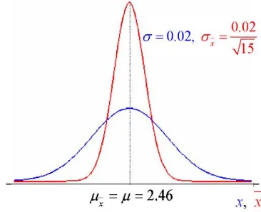
Approximate the sampling distribution of the sample mean by obtaining 200 simple random samples of size n = 20 from the population of weights of pennies minted after 1982 (=2.46 grams and =0.02 grams)
Figure 1. Probability distribution using Pearson
The mean of the 200 sample means for n=20 is still 2.46, but the standard deviation is now 0.0045 (0.0086 for n=5). As expected, there is less variability in the distribution of the sample mean with n=20 than with n=5. Suppose that a simple random sample of size n is drawn from a large population with mean and standard deviation.
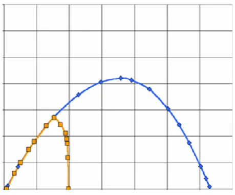
Figure 2. Proposed density trajectory model
B. Spatial Query Processing
results differ for different locations based on the spatial property. To efficiently compute location-based results with the trajectory model there are several number of algorithms used in literature. The proposed Rife Density trajectory model along with KNN query helps to process the spatial query processing.. These algorithms assume that the query location is an exact location point. Spatial query processing which takes a spatial range as the input of user location and performs the dynamic clustering algorithm to a point or a line in existing location based systems. The distance and mobility based spatial queries are more practical when compared with static skyline environments.
Query Processor supports efficient processing of probabilistic range queries on the Rife-density trajectories managed in the system. Specifically the processor implements the well-known filter-and-refinement paradigm. At the filter step, both a temporal R+-tree and a hash table are used to quickly prune those trajectory records whose time or position attributes are irrelevant to a given query condition. At the refinement step, the query processor evaluates whether each candidate resulted from the filtering step actually satisfies the given query (probability) condition. This process is performed by calling probability computation functions that are built-on Pearson densities in a precise manner.
Spatial probabilistic range queries are possibly the most common query type on uncertain trajectories, as they can effectively retrieve uncertain objects or trajectories using solid mathematical foundations in probability theory.Algorithm 1 presents the overall mechanism for processing spatial range queries, consisting of the filtering phase in Lines 1, 2 and 3and the ranking phase in Lines 7–12.
The proposal introduces an efficient mechanism for probabilistic range queries on Rife-density trajectory databases. The framework first extends the definition of probabilistic range queries on Rife -density trajectories. Then it presents access methods to index Rife -density trajectories, as well as an algorithm for assessing the optimal queries based the indexes. Note that other probabilistic query types (e.g., probabilistic nearest neighbor queries) can also be evaluated over rife-density trajectories using existing KNN query-processing methods, as the uncertain trajectory model offers full
information in terms of probability distribution at each position, which is sufficient for the probabilistic distance measures used in previous works.
C. Indexing Method
The third contribution is to present an effective mechanism that indexes evolving-rife density trajectories, and efficiently evaluates probabilistic range queries using the indexes. The proposal introduces a Indexing method to address the query processing in uncertain environment problem. To address this problem, the study utilizes a temporal R+–tree as well as a reverse key index and hash table for quickly identifying a candidate set of uncertain trajectories, by dynamically computing the rank for each point and service. This helps to satisfy a given query condition. This process does not affect by any uncertainty object queries and results. The process does not a part of information loss during probabilistic query processing.
SR Index
organize any-dimensional data by representing the data by a minimum bounding box. R+–tree is an extension of the R–tree. In contrast to R–tree bounding rectangles of the nodes at one level don‟t overlap in this structure.
Figure 3. Temporal R+-Tree
This feature decreases the number of searched branches of the tree and reduces the time consumption for searching. In the R+–tree it is allowed to split data objects so that different parts of one object can be stored in more nodes of one tree level. If a rectangle overlaps another one, this decomposes it into a group of non overlapping rectangles which cover the same data objects. This process increases space consumption but allows zero overlap of the nodes and therefore reduces the time consumption for service retrieval.
Every node bounds with its children and a node can have many objects in it. The leaves point in the tree represents the actual objects and the height is always log n (it is height balanced). The main advantage of using temporal R+ trees in the RDT model is follows.
Nodes are not overlapped with each other in R+ trees, Point of Interest based query results are covered by at most one node.
A acyclic path is followed and appropriate nodes are visited than with the R-tree
The spatial query framework with uncertainty consists of five steps. Given a query, this first find all sub graphs that intersect with the query range. Next, this uses the Filter Trees of these sub graphs to retrieve the points whose strings are potentially similar to the query string.
In the third step, this prunes away some of these candidate points by calculating the lower and upper bounds of their distances to the query point, using VR. The fourth step is to further prune away some candidate points using the exact edit distance between the query string and strings of remaining candidates. After this step, the string predicate has been fully explored. In the final step, for the remaining candidate points, this checks their exact distances to the query point and return those with distances within r.
Objects in R+-Trees:
The location point tree saves the location points along with the temporal detail. The system identifies the service by using the spatial index key which will be stored on the Temporal R+-Tree. To speed up query processing in uncertain trajectory database the reverse indexes has applied. This finds all the objects‟ which is related to the temporal data and finds the subspace scopes by the Temporal R+ tree where the subspace spatial scopes are stored in the leaf nodes as data entries. Moreover to support query processing this follows similar ideas of existing R-tree and R*-tree to maintain a series of digests for all index nodes in the tree structure. And this also uses the reverse index to handle the direction in trajectories.
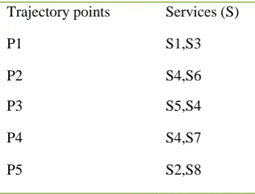
Figure 4. Location and service point
Table 1. Location point and available services in the location
Trajectory points Services (S)
P1 S1,S3
P2 S4,S6
P3 S5,S4
P4 S4,S7
P5 S2,S8
The above table 4.1 represents the location point and available services in the location. The system can able provide appropriate services for the query based on the location point and temporal based service list. This helps in two ways. One is the retrieval time has reduced. And the next is managing uncertainty in trajectories in the tree helps to avoid wrong results.
Algorithm 1 : Temporal R+- tree
Steps:
1. Initial location source with respect point p1,p2..pn and time T1,T2..Tn
2. For every point in the source P do
a. Initialize service S1…Sn for respective points.
b. Set index for every service
3. Get rank for each service and store into the ascending order.
4. Store the node in the top level based on the rank 5. Prune the other items from the TR+tree.
The above algorithm represents the data extraction from temporal R+ tree based on the user query. This initially collects location points and its respective time. After that this will enable the service extraction from repository using TR+ tree.
Spatial Reverse index (SR-index)
The location based reverse index helps to track all the service related to the user query. For fast search SR index method has been proposed to provide appropriate service, the point selection also helps to avoid the uncertainty in service selection by location based servers. The proposed system designed a variant of skyline reverse index that is optimized for multidimensional temporal points with reference keys and is thus named the spatial reverse index (SR-index). This access method successfully incorporates point coordinates into a conventional reverse index with small extra space which is owing to a delicate compact storage scheme for fast accessibility. Meanwhile an SR-index preserves the spatial locality of data points and temporal details, and comes with an R+- Tree built on every reverse list at little space overhead. Finally it offers two competing ways for skyline query processing in location based search. This can consecutively merge multiple lists very much like merging traditional reverse lists by unique id of each object. This can also leverage the LP trees to browse the points of all relevant lists in ascending order of their distances to the query point by CSP.
IV.
CONCLUSION
This work re-modulates the existing trajectory models to handle the uncertainty in trajectory database. The system proposed a new and effective approach to modelling the uncertainty of trajectories, as their modeling powers are insufficient to capture several important properties of trajectory data. To complement this, this proposed the Rife-density trajectory model that represents a trajectory as time-dependent Pearson distributions. This then introduced Rife density trajectory model along with effective indexing technique. The usage of temporal R+ Tree with inverted list improved the searching efficiency, which is suitable for vector based data searching that effectively infer time-varying densities of location data. This also developed an efficient mechanism to process spatial range queries on indexed Rife-density trajectories.
V.
REFERENCES
[1]. Brakatsoulas, Sotiris, et al. "On map-matching vehicle tracking data." Proceedings of the 31st international
conference on Very large data bases. VLDB
Endowment, 2005.
area." Wireless, Mobile and Sensor Networks,
2007.(CCWMSN07). IET Conference on. IET, 2007.
[3]. Kuijpers, Bart, and Walied Othman. "Trajectory databases: Data models, uncertainty and complete query languages." Database Theory–ICDT 2007. Springer Berlin Heidelberg, 2006. 224-238.
[4]. Liu, Hechen, and Markus Schneider. "Querying moving objects with uncertainty in spatio-temporal databases." Database Systems for Advanced
Applications. Springer Berlin Heidelberg, 2011.
[5]. Hajari, Hadi, and Farshad Hakimpour. "A Spatial Data Model for Moving Object Databases." arXiv preprint
arXiv:1403.3304 (2014).
[6]. Karthikeyani, V., and I. ShahinaBegam. "Different Direction Flow Analysation Algorithm (DDFAA) Of Moving Object Using Spatial
[7]. Trajcevski, Goce, et al. "The geometry of uncertainty in moving objects databases." Advances in Database
Technology—EDBT 2002. Springer Berlin Heidelberg,
2002. 233-250.
[8]. Pelekis, Nikos, et al. "Clustering uncertain trajectories." Knowledge and Information Systems 28.1 (2011): 117-147.
[9]. F. Diebold, T. Gunther, and A. Tay, “Evaluating density forecasts with applications to financial risk management,” Int. Econ. Rev., vol. 39, no. 4, pp. 863– 883, Nov. 1998.
[10]. Z. Ding, “UTR-Tree: An index structure for the full uncertain trajectories of network-constrained moving objects,” in Proc. 9th Int. Conf. MDM, Beijing, China, 2008, pp. 33–40.
[11]. Z. Ding and R. H. Güting, “Uncertainty management for network constrained moving objects,” in Proc. 15th
Int. Conf. DEXA, Berlin, Heidelberg, Germany, 2004,
pp. 411–421.
[12]. E. Frentzos, K. Gratsias, and Y. Theodoridis, “On the effect of location uncertainty in spatial querying,” IEEE
Trans. Knowl. Data Eng., vol. 21, no. 3, pp. 366–383,
Mar. 2009.
[13]. J. Hightower and G. Borriello, “Location systems for ubiquitous computing,” IEEE Comput., vol. 34, no. 8, pp. 57–66, Aug. 2001.
[14]. K. Hornsby and M. J. Egenhofer, “Modeling moving objects over multiple granularities,” Ann. Math. Artif.
Intell., vol. 36, no. 1–2, pp. 177–194, Sept. 2002.
[15]. Jain, E. Y. Chang, and Y.-F. Wang, “Adaptive stream resource management using Kalman filters,” in Proc.
2004 ACM SIGMOD Int. Conf. Manage. Data, pp. 11–
22.
[16]. A S. Jensen, H. Lahrmann, S. Pakalnis, and J. Runge, “The INFATI data.” TIMECENTER, Tech. Rep. TR-79. 2008.
[17]. H. Jeung, H. T. Shen, and X. Zhou, “Mining trajectory patterns using hidden Markov models,” in Proc. 9th Int.
Conf. DaWaK, Regensburg, Germany, 2007, pp. 470–
480.
[18]. B. Kanagal and A. Deshpande, “Online filtering, smoothing and probabilistic modeling of streaming data,” in Proc. 2008 IEEE 24th ICDE, Cancun, Mexico, pp. 1160–1169.
[19]. D. E. Knuth, The Art of Computer Programming, Vol.
3, Sorting and Searching, 2nd ed. Redwood City, CA,
USA: Addison Wesley Longman Publishing Co., Inc., 1998.
[20]. B. Kuijpers, B. Moelans, W. Othman, and A. A. Vaisman, “Analyzing trajectories using uncertainty and background information,” in Proc. 11th Int. Symp. SSTD, Aalborg, Denmark, 2009, pp. 135–152.
[21]. B. Kuijpers and W. Othman, “Trajectory databases: Data models, uncertainty and complete query languages,” J. Comput. Syst. Sci., vol. 76, no. 7, pp. 538–560, Nov. 2010.
[22]. A. LaMarca and E. de Lara, Location Systems: An Introduction to the Technology behind Location
Awareness. San Rafael, CA, USA: Morgan and
Claypool Publishers, 2008.
[23]. H. Liu and M. Schneider, “Querying moving objects with uncertainty in spatio-temporal databases,” in Proc.
16th Int. Conf. DASFAA, Hong Kong, China, 2011, pp.
357–371.
[24]. H. Lu, B. Yang, and C. S. Jensen, “Spatio-temporal joins on symbolic indoor tracking data,” in Proc. IEEE
27th ICDE, Hannover, Germany, 2011, pp. 816–827.
[25]. H. J. Miller, “A measurement theory for time geography,” Geographical Anal., vol. 37, no. 1, pp. 17– 45, 2005
[26]. Emrich, T., Kriegel, H. P., Mamoulis, N., Niedermayer, J., Renz, M., & Züfle, A. (2014, April). Reverse-nearest neighbor queries on uncertain moving object trajectories. In International Conference on Database
Systems for Advanced Applications (pp. 92-107).
Springer International Publishing.
[27]. Eleazar Leal, Le Gruenwald, Jianting Zhang and Simin You, "TKSimGPU: A Parallel Top-K Trajectory
Similarity Query Processing Algorithm for GPGPUs",
Proceedings of the 2015 IEEE International Big Data Conference, Oct 29-Nov 1 2015, Santa Clara
[28]. Jianting Zhang, Simin You and Le Gruenwald, "Spatial Join Query Processing in Cloud: Analyzing Design
Choices and Performance Comparisons", Proceedings