ISSN Online: 2152-2219 ISSN Print: 2152-2197
DOI: 10.4236/jep.2019.102015 Feb. 15, 2019 260 Journal of Environmental Protection
An Integrated Method for the Selection of
Optimum Locations for Landfilling Utilizing
GIS: A Case Study of the State of Kuwait
Meshal Mohammad Abdullah
1,2*, Sabah Al-Jenaid
3, Waleed Khalil Zubari
4, Jasem Al-Ali
51Department of Ecosystem Science and Management, Texas A&M University, College Station, TX, USA
2Natural Environmental Systems and Technology (NEST) Research Group, EcoLife Science Research and Consultation,
Hawally, Kuwait
3Geoinformatics Department, College of Graduate Studies, Arabian Gulf University, Manama, Bahrain
4Water Resources Management Program, College of Graduate Studies, Arabian Gulf University, Manama, Bahrain 5Geography Department, College of Social Science, Kuwait University, Shuwaikh, Kuwait
Abstract
With the rise of urbanization, change in lifestyles, and food habits, the amount of Municipal Solid Waste (MSW) has been rapidly increasing with the composition constantly changing. Landfilling is the common approach for waste management in Kuwait, and around 90% of municipal wastes are disposed in landfill sites. Therefore, this study focused on the integration of different methods for the process of allocating optimum sites for MSW land-fills, in four main stages. The first stage focused on utilizing the gap analysis method for the identification of effective criteria for landfill site selection, by comparing the criteria in Kuwait with the World Bank guidelines, US EPA, and Australia EPA, to suggest the best criteria for landfill site selection. These criteria were applied in the second and third stages to determine suitable lo-cations for landfill sites using the Geographical Information System (GIS). In the last stage, the suitable areas were evaluated by studying the socioeconomic aspects such as distance to waste generation center, the proximity of existing roads, and lifespan to select optimum locations for landfilling. The results in-dicated that only one site with a total area of 12 km2 was considered optimum for MSW landfill sites in Kuwait. Therefore, moderate suitability areas were indicated to support and provide decision makers with more options. The moderately suitable sites are also suitable for landfilling, but they need to be designed carefully in order to avoid negative impacts on the environment and human health. Therefore, we conclude that there is an urgent need to apply the integrated waste management system in Kuwait, as well as to develop a long-term strategic plan.
How to cite this paper: Abdullah, M.M., Al-Jenaid, S., Zubari, W.K. and Al-Ali, J. (2019) An Integrated Method for the Selec-tion of Optimum LocaSelec-tions for Landfilling Utilizing GIS: A Case Study of the State of Kuwait. Journal of Environmental Protec-tion, 10, 260-275.
https://doi.org/10.4236/jep.2019.102015
Received: March 24, 2018 Accepted: February 12, 2019 Published: February 15, 2019
Copyright © 2019 by author(s) and Scientific Research Publishing Inc. This work is licensed under the Creative Commons Attribution International License (CC BY 4.0).
DOI: 10.4236/jep.2019.102015 261 Journal of Environmental Protection
Keywords
Municipal Solid Waste, ModelBuilder, Gape Analysis, Spatial Analysis, Waste Management
1. Introduction
Population growth and changes in socio-economic structures increase the per capita consumption leading to more waste production, which has a detrimental impact on the environment [1] [2]. Municipal Solid Waste Management (MSWM) is considered one of the most crucial environmental challenges that developing countries face today [3][4], as landfills are the common practices in most urban areas in developing countries because of their cost effectiveness [5]. Landfill site selection is also a critical issue in the urban planning process due to its enormous impacts on the economy [6], ecology, health, and environment [7] [8][9].
Therefore, it is necessary to consider sanitary landfills which include an engi-neered facility for MSW, which is designed and operated to minimize public health and environmental impacts [10]. Sanitary landfills should be intended to protect humans and the environment from emitted gasses and fluids by using impervious liners, gas collection vents, and leachate collection pipes [11] [12]. Many landfills are designed for a lifespan of 20 or 30 years and still require post closure monitoring for up to 30 years to ensure that their environmental effects are controlled [13] [14]. Due to the negative impacts of landfilling on the envi-ronment and human health, selecting new proper landfill sites requires spatial process as well as identifying effective criteria [15][16]. The criteria associated with landfill sitting can be grouped into three main categories, namely, engi-neering and infrastructure, environmental and socio-cultural, and economical [17][18]. These criteria prohibit a landfill from being placed within a particular area. The selected criteria should be met by all acceptable landfill locations [19].
Geographic Information Systems (GIS) is one of the most common tools used in selecting landfill sites. GIS can manage and analyze varied amounts of data associated with the process of setting up solid waste landfills, as well as its flex-ibility, numerical efficiency in calculations involving combinations and statistical exploration of spatial variables [20]. Previous studies also illustrate that the inte-gration of GIS and multi-criteria analysis is a powerful method for the selection of landfill sites [2] [21]. Moreover, GIS plays a significant role in providing a cost effective and efficient analysis of landfill site attributes; however, it can be limited to the lack of available data [17].
DOI: 10.4236/jep.2019.102015 262 Journal of Environmental Protection presents an integrated approach for the selection of suitable locations for landfil-ling. The major objective is to develop a methodology for the selection of opti-mum landfill sites by integrating the ecological, social, and economical aspects using the Geographical Information System (GIS) and gap analysis technique. Specific objectives include: 1) developing a proper list of guidelines for the selec-tion of landfill sites in Kuwait using the cap analysis approach, and 2) integrat-ing environmental and socioeconomic criteria to select optimum locations for landfilling in Kuwait by utilizing GIS.
2. Methods and Materials
2.1. Study Area
The State of Kuwait is located in the northwestern corner of the Arabian Gulf. It encompasses an area of approximately 17,818 square kilometers extending be-tween latitudes 28˚30'N and 30˚05'N, and longitudes 46˚33'E and 48˚30'E (Al Baz and Al Sarawi, 2000). Kuwait has a desert climate, hot and dry with occa-sional rain, mostly in the spring. Rainfall varies from 75 to 150 mm per year across the country. The summer seasons are relatively hot and are often accom-panied by dust storms where the average daily temperatures in summer range from 42˚C to 46˚C. The prevailing wind is in the northwest direction, and hu-midity increases during late summer with thunderstorms. However, the weather gets colder in late November, dropping temperatures to as low as 3˚C at night; daytime temperature is in the upper 20˚C range (Ministry of Planning, 2007).
2.2. Methodology
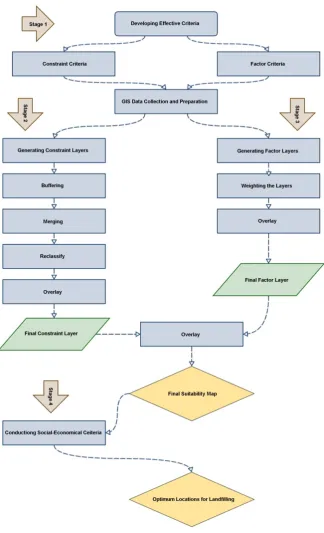
This study incorporates four stages for the selection of new MSW landfill sites in Kuwait (Figure 1). These stages include 1) the identification of sufficient criteria for site selection using gap analysis method, 2) determining unacceptable areas, 3) weighting the acceptable areas, and 4) studying the socioeconomic factors to evaluate the suitability of the selected areas in order to determine optimum loca-tions for landfilling. The second and third stages were accomplished using spa-tial analysis and ModelBuilder in ArcGIS to produce suitability maps highlight-ing “suitable” geographic areas derived from weighted and combined map layers based on the established criteria in stage one.
2.2.1. Identification of Suitable Criteria for Landfill Site Selection
DOI: 10.4236/jep.2019.102015 263 Journal of Environmental Protection Figure 1. Study methodology.
2.2.2. GIS Data Collection and Preparation
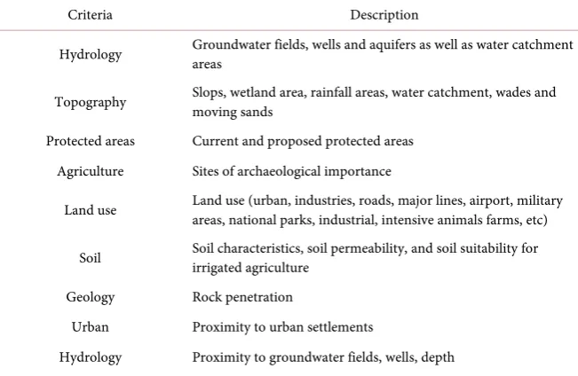
DOI: 10.4236/jep.2019.102015 264 Journal of Environmental Protection Table 1. Selected criteria for the selection of MSW landfill sites in Kuwait.
Criteria Description
Hydrology Groundwater fields, wells and aquifers as well as water catchment areas
Topography Slops, wetland area, rainfall areas, water catchment, wades and moving sands
Protected areas Current and proposed protected areas Agriculture Sites of archaeological importance
Land use Land use (urban, industries, roads, major lines, airport, military areas, national parks, industrial, intensive animals farms, etc)
Soil Soil characteristics, soil permeability, and soil suitability for irrigated agriculture
Geology Rock penetration
Urban Proximity to urban settlements
Hydrology Proximity to groundwater fields, wells, depth Agriculture and protected areas Proximity to agriculture fields and protected areas
of their related cantons from the study, such as seismic zones, fault lines, arc-heological and historical areas, and vegetation types and communities. Further-more, some of the available data have been collected in an analog format. They were first digitized into vector format by using on-screen digitizing and then in-troduced to the GIS system. All data were stored in the same coordinate system in order to display them together, and were all transferred to Universal Trans-verse Mercator (UTM) projection (WGS 1984, Zone 38N).
The digital elevation model (DEM) was built up by using 3D analysis tools. Contour lines and spot heights maps were used in building DEM map. The slope layer was derived from the DEM by using the surface function in the spatial analysis tools. However, depth to groundwater layer was created from the water level contour lines of Kuwait Group in the GIS software using the spatial analys-es tools. Then, the differencanalys-es between the groundwater levels and DEM were extracted using raster calculator in the spatial analyses tools to create the depth of groundwater layer.
2.2.3. Determining Unacceptable Areas
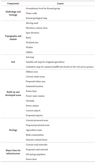
DOI: 10.4236/jep.2019.102015 265 Journal of Environmental Protection Table 2. Collected GIS layers.
Component Layers
Hydrology and Geology
Groundwater level for Kuwait group Water wells
Kuwait geological map
Topography and climate
Moving sand Elevation contour lines Spot elevation Basin Wetland area Wadies Sabkha
Soil
Soil map
Suitable soil map for irrigated agriculture
Limitation map for sanitary landfill sites based on the soil survey project.
Build up and developed areas
Military area Current urban areas Proposed urban area Industrial location Power lines Power water station Oil fields
Power station Current airport Proposed airports
Ecology
Current protected areas Proposed protected areas Agriculture areas Birds communities Intensive animal farms
Major lines for infrastructure
Current road networks Proposed road network Oil and gas pipelines Power lines
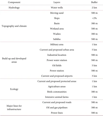
DOI: 10.4236/jep.2019.102015 266 Journal of Environmental Protection Table 3. Constraint criteria and buffer distance.
Component Layers Buffer
Hydrology Water wells 2 km
Topography and climate
Moving sand 500 m
Slops <2%
Basin 300 m
Wetland area 500 m
Wadies 300 m
Sabkha 500 m
Build up and developed areas
Military area 1 km
Current and proposed urban area 5 km
Industrial location 500 m
Power water station 500 m
Oil fields 5 km
Power station 500 m
Current and proposed airports 3 km
Ecology
Current and proposed protected areas 1 km
Agriculture areas 1 km
Birds communities 300 m
Intensive animal farms 1 km
Major lines for infrastructure
Current and proposed roads 500 m Oil and gas pipelines 300 m
Power lines 500 m
unsuitable land). Each group layers were merged to create a constraint layer for each group, and then the six constraint group layers were combined using the overlay function to create the final constraint map.
2.2.4. Weighting the Acceptable Areas
DOI: 10.4236/jep.2019.102015 267 Journal of Environmental Protection Table 4. Factor criteria.
Component Description
Soil Suitable soil irrigated agriculture Urban Proximity to current urban areas Road networks Proximity to main roads
Hydrology Depth to groundwater
Agriculture areas Proximity to agriculture Protected areas Proximity to protected areas
from 500 m (considered as a low suitability area) to 5000 m (considered as a high suitability area). Groundwater factor was weighted based on how deep the groundwater was from the surface, where the high depth areas were given low values as a high suitable area, while the low depth areas were given high values as low suitable areas. Factor layers were also converted into raster format, reclassi-fied into different classes, and overlaid together using the weighted overlay func-tion in the spatial analysis tools.
2.2.5. Final Suitability Map
This approach consisted of the identification of locations that may present fa-vorable conditions to waste disposal. The various layers prepared for environ-mental aspects were intersected to screen out unsuitable lands. The final con-straint layer and the final factor layer were merged together using raster calcula-tor to produce the final suitability map. A custom scale of 1 to 4 was chosen for this overlay since only four classes are appropriate for the final suitability maps. These four classes’ areas comprise restricted, low suitability, moderate suitabili-ty, and high suitability. The high suitability locations were taken into considera-tion in the final stage.
2.2.6. Selecting the Optimum Locations
After the identification of suitable sites, the last stage is to evaluate these sites to locate the optimum locations by considering the socioeconomic aspects, namely waste transportation distance, proximity to roads network, and lifespan.
Waste transportation distance: It is estimated that a distance of more than
50 km from the waste generation center will take more than 40 minutes of driv-ing. For this purpose, all areas located outside this range were eliminated.
Proximally to roads network: Landfill location must also be close to roads
network in order to facilitate transportation and consequently reduce relative costs. However, the areas that are intersecting with roads network with a dis-tance of 3 km were extracted.
Landfill lifespan: It is one of the critical criteria that must be considered due
equa-DOI: 10.4236/jep.2019.102015 268 Journal of Environmental Protection tion [25]:
Population
R VI d
w
= ×
In which VI is the required volume for the landfill per year, R is the specific solid waste projection rate (= 1.4 kg/capita/Day), W is volumetric weight of solid waste after compacted (800 kg/cubic meter), and D is number of day in one year (365 day/year).
3. Results
3.1. Criteria Evaluation
The results showed that Kuwait regulations covered the lowest number of the World Bank guidelines compared with Australia and USA. The Australian guidelines covered about 70% of the World Bank guidelines, USA covered about 50%; however, Kuwait was the lowest, with 35%. Various gaps have been identi-fied between Kuwait and other countries. However, these gaps may not be a weakness in the regulations of the countries due to regional, climatic, and topo-graphic differences. Therefore, these gaps were reviewed in order to select the ones that are applicable to desert environments such as Kuwait, and eliminate the ones that are not applicable. We found that most of these criteria are appli-cable and were considered in our analysis. Eighteen criteria were modified and added to the Kuwait regulations. We then generated a new list of criteria for the selection of municipal solid waste landfill sites in Kuwait, which was applied in this study to select suitable locations for landfilling in Kuwait. We also selected the needed information in order to assess each creation in the list. The new list of guidelines and needed data are summarized in the form of a table (Table 5). The results showed that the major weaknesses were concentrated in four com-ponents including lifespan, land use, site access and transportation, and socioe-conomic factors.
3.2. Optimum Locations for Landfill Sites
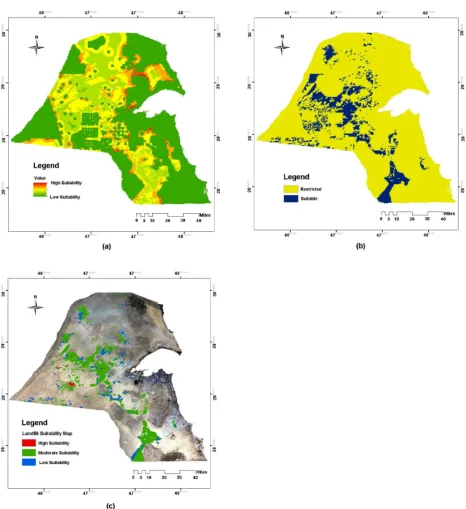
The final factor layer (Figure 2(a)) and the final constraint layer (Figure 2(b)) were merged using raster calculator to produce the final suitability layer (Figure 2(c)). The final suitable locations were classified into four classes including high suitability, moderate suitability, low suitability, and restricted based on the number of criteria covered by each class. The results showed that only 24.3 km2 of the entire country are highly suitable for landfilling. However, 1548 km2 are considered moderate suitability, 347 km2 are considered low suitable, and 14,367 km2 are restricted areas for landfilling. This illustrates that only few areas are highly suitable for landfill sites where all the selected criteria were met.
DOI: 10.4236/jep.2019.102015 269 Journal of Environmental Protection Table 5. List of guidelines for the selection of suitable locations for landfilling in Kuwait.
Component Criteria KEPA Modified Required maps
Lifespan
Depth of landfill from 10 to 25 m √ Depth of groundwater + geological
Land space and volume with a capacity to fill for at least 20
years √ -
Solid waste density of 800 - 1000 kg/cubic meter √ -
Topography and climate
Away from areas of high wind √ Climate
Away from wetland areas should be at least 500 m Sabkah + wetlands
Slopes topography about 2% √ Digital elevation model
No wades within 300 meters of landfill site √ Wades
Away from the underground recourse area √ Oil fields + oil wells Away from rainfalls areas should be at least 500 m √ Depression: watershed Away from moving sand areas should be at least 500 m √ Moving sand areas
Soil
Availability of soil cover (for this purpose clay is the
best type of soil cover) √ Soil profile
Soil should be impermeable in the landfill area (soil permeability should be less than 10−7 cm/s in order to
be used as landfill liner)
√ Soil profile
Special consideration for suitability soil for revegetation √ Soil suitability
Geology and hydrology
No stream within 300 meters of landfill site √ Digital elevation model No fault lines within 500 meters or significantly fractured
geologic structure √ Geological structure
Water catchment should be more than 500 meters
of landfill site √ Basin
Depth of the groundwater at least 10 meters √ Depth of groundwater Away from seismic impact zones at least 100 m √ Potential seismic zones Away from the groundwater wells, filed and recharge areas
(2 km) √ Groundwater water filed + wells + aquifers
Special consideration for aquifers (2 km) √ Groundwater aquifers
Land use
Major lines of electrical transmission or other infrastructures
should be at least 500 m √ Power lines + oil and gas pipelines + oil trenches Residential developments should be at least 2 km from landfill √ Land use
Airport area should be at least 1.5 km from landfill √ Land use Avoid sitting within 1.5 km from archeological and historical
areas √ Land use
No sitting within 2 km from socio-politically sensitive areas (agriculture areas, military areas, national parks,
entertainment areas and intensive animal's farms) √ Land use Endangered species breeding and significant protected areas as
well as areas that might lose habitat or have biodiversity
impacts should be at lest 500 meters from landfill √
Bird nests + protected area + vegetation areas + land suitability for revegetation
Site access and transport
Close to the road network √ Road network
Transfer station, if needed, should be 2 hours of travel time
from landfill site √ Road network
Economic factors Waste travel time of 30 minuets √ Road network
DOI: 10.4236/jep.2019.102015 270 Journal of Environmental Protection Figure 2. Suitable locations for Landfill sites in Kuwait: (a) Final factor layer, (b) Final constraint layer, and (c) Final suitability layer.
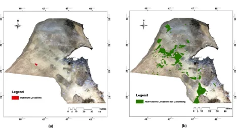
DOI: 10.4236/jep.2019.102015 271 Journal of Environmental Protection generation at least 15 years (in case of starting the operation in 2015). Therefore, areas less than 4.5 square kilometers were eliminated. The results showed that only one location was greater than 4.5 km2; however, the remaining areas were less than 1 km2 to end up with only one optimum location with a total area of 12
km2 (Figure 3(a)) which can serve for at least 15 years (Table 6).
Since only one location was considered as an optimum location for landfilling, we relaxed the criteria to provide other alternative areas to support decision makers in Kuwait with alternative solutions. Alternative areas were extracted from the moderate suitability areas in the final suitability layer, which were also considered suitable areas. The same economic aspects criteria (including the waste transportation, distance to roads and landfill lifespan) were also applied to these areas. As a result, several alternative areas were located as suitable areas for landfill sites in Kuwait with a total area of 1328 km2 (Figure 3(b)). However, these locations could be considered suitable areas, but not optimum areas since they did not meet all the selected criteria. Therefore, they will require special implementation process to prevent any environmental disturbance.
4. Discussion and Conclusions
Our results show that developing a list of suitable criteria is a critical stage in the selection of suitable locations for landfilling. It is also necessary to integrate both environmental and socioeconomic aspects as the results show that the socioeco-nomic aspects including waste transportation distance, proximity to roads net-work, and lifespan play an important role in evaluating the suitable locations for landfilling.
We also find that the use of GIS model in the selection of suitable landfill sites incorporating the evaluation of multiple criteria has many advantages. Firstly, GIS is a powerful tool that enables organized and systematic analysis of spatial data. For instance, large amounts of data including thirty layers covering several different criteria are integrated and analyzed together, which is difficult to process without using the GIS spatial analysis. Secondly, the results of the analy-sis can also be presented in the form of functional output maps. Finally, the model and its operational procedures can be visually simplified and represented as a schematic diagram (flow chart). Therefore, GIS technology proves to be an effective tool that can be used in the landfill site selection. This system has the capability to handle a huge amount of spatial data and evaluate changes in sce-narios as well as to save huge amounts of time.
DOI: 10.4236/jep.2019.102015 272 Journal of Environmental Protection Figure 3. (a) Optimum Locations for landfilling after conducting the socioeconomic criteria, and (b) alternative locations for landfilling after relaxing the selected criteria to support decision makers.
Table 6. Total area for future potential landfill locations in Kuwait.
Suitable locations (after conducting the social-economic factors) Optimum locations Alternative locations
Total area (km2) 24.3 12 1328
gas and lechate collection, as well as groundwater monitoring. In addition, wind direction is another issue that must be considered in selecting landfill sites in the north and medial central areas of Kuwait, since the predominant wind direction in Kuwait is north-west [28], which may move the pollutant gases to urban areas. Furthermore, the moderate suitability sites located in southern areas are close to Al Wafra agriculture areas, which may also be affected if landfills are se-lected in close proximity.
[image:13.595.56.536.378.417.2]DOI: 10.4236/jep.2019.102015 273 Journal of Environmental Protection suitable sites for MSW landfills to minimize their negative impacts on human health and the environment, as well as to develop a long-term strategic program (for the next ten to fifteen years) to conduct alternative environmental friendly options instead of landfilling.
This work presents an integrated methodology for selecting MSW sites by conducting and integrating environmental and socioeconomic criteria using GIS. We also believe that the developed methods in this work can be applicable to the selection of landfill sites at any location. However, in the next stage, we believe that it is important to conduct ground trothing field visit to evaluate these locations in the field, especially the alternative locations as several loca-tions are identified and ranked from the highest to the lowest suitability. It is al-so important to update the criteria for landfill site selection in Kuwait as several gaps are identified. Therefore, we recommend using the selected criteria in this project to update the Kuwait EPA criteria.
Conflicts of Interest
The authors declare no conflicts of interest regarding the publication of this pa-per.
References
[1] Motlagh, Z.K. and Sayadi, M.H. (2015) Siting MSW Landfills Using MCE Metho-dology in GIS Environment (Case Study: Birjand Plain, Iran). Waste Management, 46, 322-337. https://doi.org/10.1016/j.wasman.2015.08.013
[2] El Maguiri, A., Kissi, B., Idrissi, L. and Souabi, S. (2016) Landfill Site Selection Us-ing GIS, Remote SensUs-ing and Multicriteria Decision Analysis: Case of the City of Mohammedia, Morocco. Bulletin of Engineering Geology and the Environment, 75, 1301-1309.
[3] Quadros, R., dos Santos, G.V., Tavares, A.N. and Bajay, S. (2015) Brazilian Research in Municipal Solid Waste Biogas: How Large Is It and How Far Has It Gone? Jour-nal of Solid Waste Technology & Management, 41, 95-105.
[4] Eiselt, H.A. and Marianov, V. (2015) Location Modeling for Municipal Solid Waste Facilities. Computers & Operations Research, 62, 305-315.
https://doi.org/10.1016/j.cor.2014.05.003
[5] Favery, R.L.T., et al. (2016) Study of Influential Factors on the Compaction of Mu-nicipal Solid Waste in Lysimeters. Journal of Solid Waste Technology & Manage-ment, 42, 548-558.
[6] Leme, M.M.V., et al. (2014) Techno-Economic Analysis and Environmental Impact Assessment of Energy Recovery from Municipal Solid Waste (MSW) in Brazil. Re-sources, Conservation and Recycling, 87, 8-20.
https://doi.org/10.1016/j.resconrec.2014.03.003
[7] Grisey, E. and Aleya, L. (2016) Assessing the Impact of Leachate Plumes on Groundwater Quality in the Etueffont Landfill (Belfort, France). Environmental Earth Sciences, 75, 1-18. https://doi.org/10.1007/s12665-016-5725-z
[8] Atta, M., Yaacob, W.Z.W. and Jaafar, O.B. (2015) The Potential Impact of Lea-chate-Contaminated Groundwater of an Ex-Landfill Site at Taman Beringin Kuala Lumpur, Malaysia. Environmental Earth Sciences, 73, 3913-3923.
DOI: 10.4236/jep.2019.102015 274 Journal of Environmental Protection
[9] Zania, V., Psarropoulos, P.N., Karabatsos, Y. and Tsompanakis, Y. (2008) Inertial Distress of Waste landfills. Computers & Structures, 86, 642-651.
https://doi.org/10.1016/j.compstruc.2007.07.011
[10] Younes, M.K., et al. (2015) Integrating Approach to Size and Site at a Sanitary Landfill in Selangor State, Malaysia. Environmental Engineering Research, 20, 268-276. https://doi.org/10.4491/eer.2015.0054
[11] do Carmo Nascimento, I.O., et al. (2016) Post-Treatment of Sanitary Landfill Lea-chate by Coagulation–Flocculation Using Chitosan as Primary Coagulant. Water Science and Technology, 74, 246-255. https://doi.org/10.2166/wst.2016.203
[12] Fernandes, A., Santos, D., Pacheco, M.J., Ciríaco, L. and Lopes, A. (2016) Electro-chemical Oxidation of Humic Acid and Sanitary Landfill Leachate: Influence of Anode Material, Chloride Concentration and Current Density. Science of the Total Environment, 541, 282-291. https://doi.org/10.1016/j.scitotenv.2015.09.052
[13] Arendse, L. and Godfrey, L. (2002) Waste Management Indicators for National State of Environment Reporting. Environmental Report, Centre for Scientific and Industrial Research (CSIR), South Africa, Pretoria.
[14] Armstrong, M. and Rowe, R. (1999) Effect of Landfill Operations on the Quality of Municipal Solid Waste Leachate. Proceedings of 3rd International Landfill Sympo-sium, Cagliari, 1999, 81-88.
[15] Chang, N.-B., Parvathinathan, G. and Breeden, J.B. (2008) Combining GIS with Fuzzy Multicriteria Decision-Making for Landfill Siting in a Fast-Growing Urban Region. Journal of Environmental Management, 87, 139-153.
https://doi.org/10.1016/j.jenvman.2007.01.011
[16] Nas, B., et al. (2010) Selection of MSW Landfill Site for Konya, Turkey Using GIS and Multi-Criteria Evaluation. Environmental Monitoring and Assessment, 160, 491-500. https://doi.org/10.1007/s10661-008-0713-8
[17] Siddiqui, M.Z., Everett, J.W. and Vieux, B.E. (1996) Landfill Siting Using Geo-graphic Information Systems: A Demonstration. Journal of Environmental Engi-neering, 122, 515-523. https://doi.org/10.1061/(ASCE)0733-9372(1996)122:6(515)
[18] Xi, B., et al. (2010) An Integrated Optimization Approach and Multi-Criteria Deci-sion Analysis for Supporting the Waste-Management System of the City of Beijing, China. Engineering Applications of Artificial Intelligence, 23, 620-631.
https://doi.org/10.1016/j.engappai.2010.01.002
[19] Sadek, S., El-Fadel, M. and Freiha, F. (2006) Compliance Factors within a GIS-Based Framework for Landfill Siting. International Journal of Environmental Studies, 63, 71-86. https://doi.org/10.1080/00207230600562213
[20] Vatalis, K. and Manoliadis, O. (2002) A Two-Level Multicriteria DSS for Landfill Site Selection Using GIS: Case Study in Western Macedonia, Greece. Journal of Geographic Information and Decision Analysis, 6, 49-56.
[21] Sekulović, D.J. and Jakovljević, G.L. (2016) Landfill Site Selection Using GIS Tech-nology and the Analytic Hierarchy Process. Vojnotehnički glasnik, 64, 769-783. https://doi.org/10.5937/vojtehg64-9578
[22] Kuwait-EPA (2001) Decision No. 210/2001, Kuwait Al Youm, Appendix of Issue No. 533—Year 47. Kuwait Environment Public Authority.
[23] Kuwait-EPA (2003) The Rehabilitation Strategy of the Closed Municipal Waste Landfill Sites in Kuwait. Kuwait Environmental Public Authority.
[24] Kuwait-Municipality (2008) Municipal Solid Waste Quantities. Municipality of Kuwait: Landfill Site Management Department.
Ma-DOI: 10.4236/jep.2019.102015 275 Journal of Environmental Protection
nual Sanitary Landfills. Pan American Center for Sanitary Engineering and Envi-ronmental Science.
[26] Heimlich, J.E., Hughes, K.L. and Christy, A.D. (1992) Integrated Solid Waste Man-agement. Publication Louisiana Cooperative Extension Service.
[27] Şener, B., Süzen, M.L. and Doyuran, V. (2006) Landfill Site Selection by Using Geo-graphic Information Systems. Environmental Geology, 49, 376-388.
https://doi.org/10.1007/s00254-005-0075-2