© 2015, IRJET.NET- All Rights Reserved
Page 1626
Automatic Detection and Reconstruction of Building Footprints from
Single VHR SAR Images
Smt. Arpita Sushrut Halewadimath
11
Lecturer, Electronics and Communication, KLS VDRIT Haliyal, Karnataka, India
---***---Abstract -
The spaceborne synthetic aperture radar(SAR) systems acquire imagery with very high spatial resolution (VHR), supporting various important application scenarios, such as damage assessment in urban areas after natural disasters. Focusing on the analysis of urban areas, which is of prime interest of VHR SAR, a method is presented for the automatic detection and reconstruction of building radar footprints from VHR SAR scenes. The main aim of the project is to automatically detect and to perform the 2D reconstruction of building radar footprints from single VHR SAR images. Finally the results show that the method has a high overall detection rate and that the radar footprints are well reconstructed, in particular
for medium and large buildings. The radar footprint
map extracted with the proposed method can be used to derive different information, such as the buildup presence index. It can also be used as a feature in the classification of the build-up areas.
Key Words: Very high spatial resolution (VHR),
Synthetic aperture radar (SAR), Building detection,
Production system, Building reconstruction.
1. INTRODUCTION
The spaceborne synthetic aperture radar (SAR) systems acquire imagery with very high spatial resolution (VHR), supporting various important application scenarios, such as damage assessment in urban areas after natural disasters. Focusing on the analysis of urban areas, which is of prime interest of VHR SAR, a method is presented for the automatic detection and reconstruction of building radar footprints from VHR SAR scenes.
The radar footprint map extracted with the proposed method can be used to derive different information, such as the buildup presence index. It can also be used as a feature in the classification of the build-up areas (e.g., according to residential and commercial areas). Indeed, radar footprints in single SAR images lack the information about the exact dimensions (length, width, height) and the location of the optical footprint of buildings. In order to derive them, the method could be combined with an iterative simulation and matching scheme as presented for
instance in for the building height extraction. In this context, the capability of the proposed method to extract the individual scattering contributions of a building in the SAR image could be used to improve the matching function as the simulator is also able to distinguish between the different contributions.
The main novelties of the proposed method are, the capability to accurately detect the radar footprint of individual buildings using only one SAR scene without the need for ancillary data, the possibility to estimate the reliability of the detected features and footprint hypothesis through a set of fuzzy functions, the flexibility to handle gable and flat roof buildings at different sizes and at various settings and the expansibility of the approach, which allows the definition of new scattering
classes and rules according to specific image
characteristics or user requirements. These characteristics make the approach valuable for supporting different application scenarios,
In the last decade, very high spatial resolution (VHR) spaceborne remote sensing sensors acquiring data with meter or submeter resolutions became widely available. These data have the potential to be employed for various important application scenarios, such as the monitoring of changes in urban areas [1], [2], the characterization of urban areas (e.g., slum mapping) [3], [4], the surveillance of the effects of violent conflicts [5], and the crisis management after natural disasters [6], [7]. For the latter application scenario, spaceborne VHR synthetic aperture radar (SAR) sensors, such as Cosmo-SkyMed [8] and TerraSAR-X [9], are of particular interest, due to their independence on the solar illumination and the relative insensitivity to the weather conditions [10], [11].
© 2015, IRJET.NET- All Rights Reserved
Page 1627
and interoperability among the different satellite systemshave improved substantially to facilitate international
satellite-based disaster-response capacities. Third,
through a number of international scientific and technical
coordination bodies, international cooperation
mechanisms were established. The main task of them is to perceive the specifications, basic observations, and monitoring requirements of current and future observing systems fully or partially dedicated to disaster management tasks.
Remote sensing satellites equipped with optical and synthetic aperture radar (SAR) imaging sensors can provide important information due to their ability to map affected areas of interest quickly and in a censorship free manner.
In such imagery, features from individual urban structures, such as buildings, can be identified in their characteristic settings in urban settlement patterns. Both the spatial extent of urbanized areas and the spatial characterization of building volume are crucial parameters to estimate affected population, estimate infrastructural damage, and enumerate economic losses resulting from the emergency event.
The development of methods for the automatic detection and reconstruction of building radar footprints from single very high resolution (VHR) synthetic aperture radar (SAR) images is a difficult task for two main reasons, the very high complexity of VHR SAR images and the need to develop efficient algorithms that can be applied to large images in order to be used in real applications.
The acquisition of more and more high-resolution SAR data over urban areas results in an urgent demand on interpretation methods for such images.
It is suitable for common buildings with different shapes. Due to imaging conditions, buildings may differ in shapes in different SAR images.
The main novelties and advantages of the proposed method are:
The capability to accurately detect the radar footprint of individual buildings using only one SAR scene without the need for ancillary data. The possibility to estimate the reliability of the
detected features and footprint hypothesis through a set of fuzzy functions.
The flexibility to handle gable and flat roof buildings at different sizes and at various settings. The expansibility of the approach, which allows the definition of new scattering classes and rules according to specific image characteristics or user requirements. These characteristics make the
approach valuable for supporting different application scenarios,
In addition, in SAR data, the hypotheses are based on different information (combination of height and topology) compared to ours (presence and semantic meaning of scattering features). Moreover, a way is introduced to quantitatively evaluate the hypotheses to automatically select the best one. The method uses the layover and double-bounce features for their construction of buildings. However, this approach proposed exploits the shadow information and introduces the concept of semantic meaning and membership grade for each primitive and footprint hypothesis. Moreover, the work was intended as a tool for the investigation of the limits and merits of information extraction from single images, and was not optimized for building reconstruction purposes.
It can also be used as a feature in the classification of the build-up areas (e.g., according to residential and commercial areas). Indeed, radar footprints in single SAR images lack the information about the exact dimensions (length, width, height) and the location of the optical footprint of buildings. In order to derive them, the method could be combined with an iterative simulation and matching scheme as presented for instance the building height extraction. In this context, the capability of the proposed method to extract the individual scattering contributions of a building in the SAR image could be used to improve the matching function as the simulator is also able to distinguish between the different contributions.
One of the main drawbacks of VHR SAR is the complexity of the images, mainly owing to the speckle effect and the side-looking geometry of the SAR sensor, hampering the interpretation of the data by non-SAR experts. This is particularly true for urban areas, where the data are mainly characterized by layover, multi bounce, and shadowing effects of the buildings.
1.1 Introduction to Synthetic-Aperture Radar (SAR)
© 2015, IRJET.NET- All Rights Reserved
Page 1628
1.2 Basic principles of SAR
SAR which is one of the active remote sensing techniques, transmits a microwave signal toward a target and receives its reflection (amplitude and phase) back to the sensor or antenna. Normally, the wavelength is in the order of 1cm to 1 m, corresponding to a frequency range of about 30 GHz to 300 MHz. SAR creates relatively high ground (pixel) resolution because it simulates a long antenna by combining electrical signals received by its sensor as it moves along a particular flight track.
SAR technology has provided terrain structural information to geologists for mineral exploration, oil spill boundaries on water to environmentalists, sea state and ice hazard maps to navigators, and reconnaissance and targeting information to military operations.
The rate or pulse repetition frequency at which pulses are transmitted and received may be constant or may vary over time.
2. Results and Discussion
The method shows in overall a high detection rate. False alarms are mostly related to the scattering from objects different from buildings (e.g. trees) that show radar footprints similar to those of buildings structures can be easily masked, either using a prioriinformation about the presence of rivers, or by extracting the rivers directly from the SAR scene. In general, the proposed method detected and reconstructed quite precisely the radar footprints of medium- and big-size buildings that fulfill the rectangular model. Radar footprints of small adjacent buildings aligned in regular patterns are also detected, but in some cases are considered as belonging to a single building.
Fig.1
Input imageThe above figure is taken as input image for the building detection. This input image is been processed for the successive stages in order to carry out building detection.
Fig.2 Speckled Image and Directional Dependent mask
result
The above two figures show the speckled image and the
directional dependent masking result. Speckle noise is
introduced to the input image. Afterwards, the image is
filtered with a Gamma MAP filter in order to reduce the
signal variability due to speckle. Both the unfiltered and
filtered images are used by the algorithm. The basic
features composing building radar footprints in VHR SAR
images are extracted from the calibrated image.
© 2015, IRJET.NET- All Rights Reserved
Page 1629
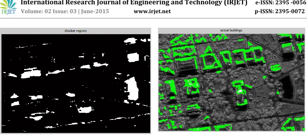
Fig.4 Shadow regionThe above figures show the bright region and shadow region detection. The detection of bright region has been carried out by using some primitive features of the input image. According to the aforementioned assumptions on building shapes, these are bright linear features with different thicknesses, and dark areas. The former are usually related to double-bounce scattering or, as the line thickness increases, to layover areas, where the roof or the facade scattering may be dominant depending on the building characteristics. The latter are due to building shadows and low-return areas.
Fig.5 Probable Candidates of building
The above figure shows the Probable Candidates of building. This step gives us a clear idea owing to the extracted features, the area of location of the buildings to be detected in the input image.
Fig.6 Actual buildings
The above figure shows actual buildings detected. Starting from the set of simple extracted bright linear features and dark areas, the method merges adjacent features in order to compose bigger objects. This is done by a production system applied to the vector domain, after a conversion from slant range to ground range, and is aimed at compensating for errors in the feature extraction step. The conversion from slant to ground range allows us to define the parameters of the method in the ground domain, which is independent on the incidence angle. After their generation, composed objects are given as input to the production system.
Fig. 7 Final buildings
© 2015, IRJET.NET- All Rights Reserved
Page 1630
3. CONCLUSION
The proposed technique can be applied to single VHR SAR images. It extends state-of-the-art feature extraction and composition steps to more structured primitives using a production system and by introducing the concept of semantic meaning. This has been done in order to compensate for the lack of information due to the fact that only one VHR SAR image is used as input. The semantic meaning represents the probability that an object belongs to a certain scattering class and is calculated via fuzzy MFs. Therefore, it allows the technique to select the most reliable primitives and footprint hypotheses during its processing steps.
In particular, the method shows very high detection rates in the case of medium and large buildings, exhibiting also a good capability to reconstruct their radar footprints. The number of false alarms is limited, and these are mostly related to other man-made structures or trees which show radar signatures similar to those of buildings. The proposed technique also reconstructs the detected radar footprints. The goal of this work is to provide as output a map.
REFERENCES
[1] F. Pacifici and W. J. Emery, “Pulse coupled neural networks for automatic urban change detection at
very high spatial resolution,” in Proc. 14th
Iberoamerican Conf. Pattern Recognit.—Progr.
Pattern Recognit., Image Anal., Comput. Vis., Appl., 2009, pp. 929–942.
[3] T. Kemper, A. Wania, and M. Pesaresi, “Supporting slum mapping using very high resolution satellite data,” in Proc. 33rd Int. Symp. Remote Sens. Environ., Sustain. Millennium Develop. Goals, 2009, pp. 480– 483.
[4] I. Baud, M. Kuffer, K. Pfeffer, R. Sliuzas, and S.
Karuppannan, Understanding heterogeneity in
metropolitan India: The added value of remote sensing data for analyzing sub-standard residential areas,” Int. J. Appl. Earth Observ. Geoinf., vol. 12, no. 5, pp. 359–374, Oct. 2010.
[5] D. Brunner, G. Lemoine, F.-X. Thoorens, and L. Bruzzone, “Distributed geospatial data processing functionality to support collaborative and rapid emergency response,” IEEE J. Sel. Topics Appl. Earth Observ. Remote Sens., vol. 2, no. 1, pp. 33–46, Mar. 2009.
[6] D. Al-Khudhairy, “Geo-spatial information and technologies in support of EU crisis management,” Int. J. Digit. Earth, vol. 3, no. 1, pp. 16–30, Mar. 2010. [7] S. Voigt, T. Kemper, T. Riedlinger, R. Kiefl, K. Scholte,
and H. Mehl, “Satellite image analysis for disaster and crisis-management support,” IEEE Trans. Geosci. Remote Sens., vol. 45, no. 6, pp. 1520–1528, Jun. 2007. [8] F. Caltagirone, G. De Luca, F. Covello, G. Marano, G.
Angino, and M. Piemontese, “Status, results, potentiality and evolution of COSMOSkyMed, the Italian earth observation constellation for risk management and security,” in Proc. IEEE IGARSS, Jul. 2010, pp. 4393–4396.
[9] R.Werninghaus and S. Buckreuss, “The TerraSAR-X mission and system design,” IEEE Trans. Geosci. Remote Sens., vol. 48, no. 2, pp. 606–614, Feb. 2010. [10]D. Brunner, G. Lemoine, and L. Bruzzone, “Earthquake
damage assessment of buildings using VHR optical and SAR imagery,” IEEE Trans. Geosci. Remote Sens., vol. 48, no. 5, pp. 2403–2420, May 2010.
[11]P. Gamba, F. Dell’Acqua, and G. Trianni, “Rapid damage detection in the Bam area using multitemporal SAR and exploiting ancillary data,” IEEE Trans. Geosci. Remote Sens., vol. 45, no. 6, pp. 1582–1589, Jun. 2007.
BIOGRAPHIES
Serving as Lecturer, Department of Electronics and Communication. KLS VDRIT Haliyal. Completed M.Tech in Digital Communication and Networking. Has an academic experience of 2 years.