ISSN (Online) : 2319 - 8753
ISSN (Print) : 2347 - 6710
I
nternationalJ
ournal ofI
nnovativeR
esearch inS
cience,E
ngineering andT
echnologyAn ISO 3297: 2007 Certified Organization, Volume 2, Special Issue 1, December 2013
Proceedings of International Conference on Energy and Environment-2013 (ICEE 2013)
On 12th to 14th December Organized by
Department of Civil Engineering and Mechanical Engineering of Rajiv Gandhi Institute of Technology, Kottayam, Kerala, India
APPLICATION OF RAPID IMPACT ASSESSMENT MATRIX
(RIAM) METHOD FOR THE FEASIBILITY STUDY OF
A MOBILITY HUB IN KOTTAYAM
B.K. Bindhu K. Jipin Sumi Manilal K.V. Vishnumaya
Assistant Professor, Dept. of Civil Engineering, RIT, Kottayam Kerala, India
M.Tech Scholar, Dept. of Civil Engineering RIT, Kottayam Kerala, India
M.Tech Scholar, Dept. of Civil Engineering RIT, Kottayam Kerala, India
M.Tech Scholar, Dept. of Civil EngineeringRIT, Kottayam Kerala, India
ABSTRACT: Traffic congestion reduces a city’s potential for creating prosperity. The mobility hub will
be a one-stop facility for visitors to access all modes of transport. A detailed environmental impact
assessment (EIA) is unavoidable before venturing a new Project and to study the effects due to an existing project. Since the assessment of the magnitude and potential of most of the impacts is purely subjective, RIAM technique has been applied for the EIA of mobility hub at Kottayam. From the RIAM output, it was found that the negative impact on environment and human health is more than the positive impacts on cultural and socio-economical aspects. Suitable mitigation measures were suggested in order to reduce the adverse impacts in future so as to create a sustainable environment.
NOMENCLATURE PC Physical / Chemical BE Biological / Ecological SC Sociological / Cultural EO Economic / Operational
1. INTRODUCTION
reference provided for the EIA, and the capacity of the assessors to cover a wide range of issues.
To overcome the drawbacks in the execution and reporting of EIA, the Rapid Impact Assessment Matrix (RIAM) was developed by Pastakia [3]. This method seeks to overcome the problems of recording subjective judgments by defining the criteria and scales against which these judgments are to be made; and by placing results in a simple matrix that allows for a permanent record of the arguments in the judgment process [4].
Kottayam is a place of tourism importance and has a vast network of rivers, backwaters, ancient religious places, and hill stations. But the town needs an urgent solution to the ubiquitous traffic blocks and serpentine queues of vehicles. A mobility hub was proposed by Government of Kerala at Kottayam keeping in view of many objectives namely accomplishment of seamless mobility with safety, a minimized ecological footprint and an attractive public realm. Railway-road-water transport facilities would be toned up and ancillary facilities such as parking areas and recreational centres rolled out as part of the project.
The proposed mobility hub will also have a helipad. Thus it helps for the seamless integration of modes at the rapid transit station and safe and efficient movement of people with high levels of pedestrian priority. There is a vibrant, mixed-use environment with higher land use intensity and will have a strategic parking management. There is a flexible planning to accommodate growth and change and effective partnerships and incentives for increased public and private investment.
One of the key issue that comes in the way of the development of the area is that the area identified for the hub is one of the most ecologically fragile area around Kottayam town as it forms part of the rich paddy fields of the Vembanad wetland region, though paddy cultivation had been discarded for the past many years in the area. However, the region plays a crucial role in the flood control of not only the town, but also the entire nearby areas. Sewage disposal is going to be a big problem and the project will lead to problems like large resource consumption, destruction of benthic flora, fauna and microbial population, water logging, constructional and operational problems.
As it is difficult to assess the magnitude and potential of both negative and positive impacts, RIAM has been developed for comparing different options, including working with mitigating measures on specific negative (or positive) impacts. The system allows for direct evaluation and comparison of components from different sectors, and provides a transparent record for future use.
Based on RIAM output in terms of relative figures and tables, the comparative statement of various components of impact over an environment was developed and presented in this paper.
2.METHODOLOGY
RIAM-ideal tool environmental evaluations
RIAM involves recording subjective judgments by defining the criteria and scales against which these judgments are to be made. The process of selecting components for an EIA which are then assessed
against criteria is known as „scoping‟.
– Sociological / Cultural (SC);
– Economic / Operational (EO)
The important assessment criteria fall into two groups:
– (A) Criteria that are of importance to the condition, and which can individually change the score
obtained;
– (B) Criteria that are of value to the situation, but individually should not be capable of changing the
score obtained. The sum of the group (B) scores is multiplied by the product of the group
(A)scores to provide a final assessment score (ES) for the condition. The process can be expressed by
(1), (2) and (3)
(A1) x (A2) = AT (1)
(B1) + (B2) + (B3) = BT (2)
(AT) x (BT) = ES (3)
Where,
(A1) and (A2) are the individual criteria scores for group (A) (B1) to (B3) are the individual criteria scores for group (B) AT is the result of multiplication of all (A) scores
BT is the result of summation of all (B) scores ES is the assessment score for the condition.
Group (A) criteria
Importance of condition (A1): It is a measure of the importance of the condition, which is assessed against the spatial boundaries or human interests it will affect. The scales are defined as given in Table 1.
TABLE 1. GROUP (A) CRITERIA –
IMPORTANCE (A1)
Value Condition
4 important to national/international
interests
3 important to regional/ national
2 important to areas immediately
outside the local condition
1 important only to the local condition
0 no importance
TABLE 2. GROUP (A) CRITERIA-MAGNITUDE OF CHANGE (A2)
Group (B) criteria
Permanence (B1): This defines whether a condition is temporary or permanent as per the scale given in Table 3.
TABLE 3. GROUP (B) - PERMANANCE (B1)
Study Area and Data Collection
The proposed mobility hub site is located in Kodimatha in Kottayam. A site visit was carried to the proposed area for mobility hub. Necessary data required for performing EIA as obtained from the site visit, Town planning office, Pollution Control Board (PCB).The methodology involves the collection of data and information according to certain guidelines and with reference to the existing data sources. Primary survey involved a questionnaire survey with the people residing near to the site and with other stakeholders. From the questionnaire survey conducted among the local people residing in and around the dump site more information were collected regarding the health aspects, surface water, ground water and air quality. Secondary data was obtained for getting information about the quality control. Analysis of water samples collected from the field showed that the surface water and ground water in the locality were of inferior quality.
Reversibility (B2): This defines whether the effect is reversible or not as per the scale given in Table 4.
TABLE 4. GROUP (B) - REVERSIBILITY (B2)
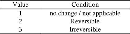
Value Condition
1 no change / not applicable
2 Reversible
3 Irreversible
TABLE 6. RANGE BANDS USED IN RIAM
RIAM Range value Range value Description of range band
108 to 72 E 5 Major positive change / impact
71 to 36 D 4 Significant positive change / impact
35 to 19 C 3 Moderate positive change / impact
10 to 18 B 2 Positive change / impact
1 to 9 A 1 Slight positive change / impact
0 N 0 No change / status quo/not applicable
-1 to –9 -A -1 Slight negative change / impact
-10 to –18 -B -2 Negative change / impact
-19 to –35 -C -3 Moderate negative change / impact
-36 to –71 -D -4 Significant negative change / impact
-72 to -108 -E -5 Major negative change / impact
3.
RESULTS AND DISCUSSIONS3. 1 Study Area
Kottayam is a city in the Indian state of Kerala, spread over an area of 55.40 km2.The proposed site‟s
geographical position is in between Latitude 90°35‟ north and Longitude 76°30‟ East. Kottayam has an average elevation of 3 meters from sea level.The study area that has been identified would fall roughly on the western side of the railway line crossing the Kodimatha area and eastern side of MC Road. Kodoor river marks the northern boundary. The nearest Highway is NH 220. There is a problem of congestion in this unit. The area is mostly covered with wet lands and paddy fields and crowded with settlement. Its
geographical position is in between Latitude 9°35‟ north and Longitude 76°30‟ East. The regional climate of the project site is more of humid in nature. The average temperature varies between 20-35°C.
The average rainfall in the region is around 3600mm. The dominant wind direction is north east during
morning hours and north west during evening hours.
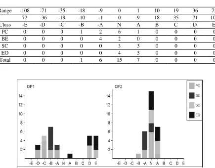
3.2 Application of RIAM
TABLE 8. SUMMARY OF SCORES IN RIAM REPORT (WITH PROJECT)
Range -108 -71 -35 -18 -9 0 1 10 19 36 72
72 -36 -19 -10 -1 0 9 18 35 71 108
Class -E -D -C -B -A N A B C D E
PC 0 2 4 2 2 0 0 0 0 0 0
BE 0 0 0 5 1 0 0 0 0 0 0
SC 0 0 1 0 0 0 0 0 0 3 2
EO 0 1 0 0 0 0 1 0 0 2 3
Total 0 3 5 7 3 0 1 0 0 5 5
TABLE 9. SUMMARY OF SCORES IN RIAM REPORT (WITHOUT PROJECT)
Range -108 -71 -35 -18 -9 0 1 10 19 36 72
72 -36 -19 -10 -1 0 9 18 35 71 108
Class -E -D -C -B -A N A B C D E
PC 0 0 0 1 2 6 1 0 0 0 0
BE 0 0 0 0 4 2 0 0 0 0 0
SC 0 0 0 0 0 3 3 0 0 0 0
EO 0 0 0 0 0 4 3 0 0 0 0
Total 0 0 0 1 6 15 7 0 0 0 0
FIGURE 1. GRAPHICAL REPRESENTATION OF RIAM
where,
is more than positive impact on cultural and socio-economic aspects. The environmental management plans has to be implemented properly and made an effective solution for the above negative impacts. The resources of future generation should be sustained without polluting and over exploiting.
3.2.Mitigation Measures
Doubling of railway makes many homeless. Sufficient rehabilitation measures have to be adopted for them. Green belt can be provided to cop up with air pollution. Widening of various inland canal that crisscross the area and widening of drains for proper waste treatment can be done. Proper laws should be enforced for the protection of biodiversity. Implementation of Environmental management plan and sustainable waste management system has to be adopted to tackle the pollution. With proper synchronization between different government departments and public participation, the project hopefully will become a fruitful venture.
4.CONCLUSIONS
RIAM method was proved to be an efficient technique for the feasibility study of mobility hub in Kottayam. The result showed that the project will impart both positive and negative impacts. The project will find solutions to problem related with congestion, unemployment, socio-economic development. Integration of environment management policies suggested to the whole Kottayam district along with the development of mobility hub, will cause very minor effect to the environment and tend to be a safest development unlike other cities.
REFERENCES
[1] W. Larry Canter, 1996. “Environmental Impact Assessment”, McGraw-Hill, Inc, Singapore.
[2] Bisset R., 1998. “Developmentsin EIA Methods In: P.Walthern (ed.) Environmental Impact Assessment- Theory and Practice”. Unwin
Hyman, UK.
[3] Pastakia, C.M.R., 1998. “The Rapid Impact Assessment Matrix (RIAM) – A New Tool for Environmental Impact Assessment, In: Kurt
Jensen (ed), Environmental Impact Assessment Using the Rapid Impact Assessment Matrix (RIAM)”, Olsen & Olsen, Fredensborg,
Denmark.
[4] Guillemo Espinoza, Barabara Richards, 2002. “Fundamentals of Environmental Impact Assessment”