3 APPROACH AND METHODOLOGY
3.1 THE EIA PROCESS
Environmental Impact Assessment (EIA) is a systematic process that identifies and evaluates the potential impacts (positive and negative) that a Project may have on the biophysical and socio-economic environment, and identifies mitigation measures that need to be implemented in order to avoid, minimise or reduce the negative impacts and also identifies measures to enhance
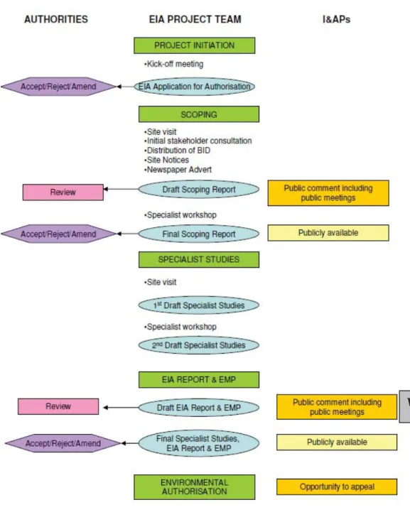
positive impacts. The overall EIA process required for developments in South Africa is shown schematically in Figure 3.1. The EIA is not fully a linear process, but one where several stages are carried out in parallel and where the assumptions and conclusions are revisited and modified as the project
progresses. The following sections provide additional detail regarding the key stages in this EIA process. These stages are:
x Scoping Phase;
x Specialist Study Phase; and
Figure 3.1 EIA Process Flow Diagram
3.2 SCOPING PHASE
The first phase of the EIA process is a Scoping Study, with an emphasis on public involvement. The various tasks and consultation activities undertaken thus far by ERM are described and summarised below.
3.2.1 Initial Site Visit and Project Initiation
As part of the project initiation ERM carried out an initial site reconnaissance visit on 2 March 2012. The purpose of the site visit was to familiarise the project team with the project proposal and affected project area and to begin the environmental and social screening and scoping process.
3.2.2 Public Participation
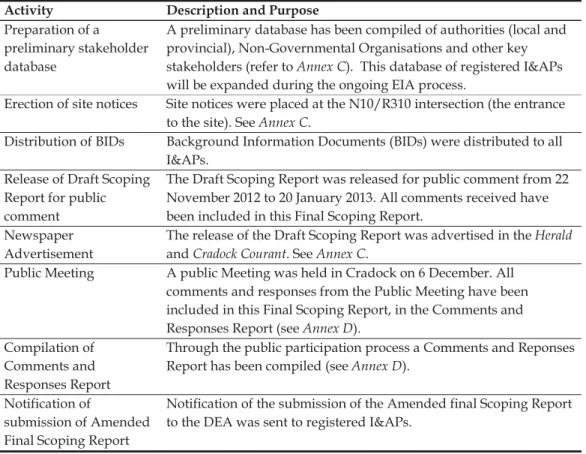
Table 3.1 details the public participation tasks that were undertaken during the Scoping Phase.
Table 3.1 Public Participation Tasks: Scoping Phase
Activity Description and Purpose Preparation of a
preliminary stakeholder database
A preliminary database has been compiled of authorities (local and provincial), Non-Governmental Organisations and other key stakeholders (refer to Annex C). This database of registered I&APs will be expanded during the ongoing EIA process.
Erection of site notices Site notices were placed at the N10/R310 intersection (the entrance to the site). See Annex C.
Distribution of BIDs Background Information Documents (BIDs) were distributed to all I&APs.
Release of Draft Scoping Report for public comment
The Draft Scoping Report was released for public comment from 22 November 2012 to 20 January 2013. All comments received have been included in this Final Scoping Report.
Newspaper Advertisement
The release of the Draft Scoping Report was advertised in the Herald and Cradock Courant. See Annex C.
Public Meeting A public Meeting was held in Cradock on 6 December. All comments and responses from the Public Meeting have been included in this Final Scoping Report, in the Comments and Responses Report (see Annex D).
Compilation of Comments and Responses Report
Through the public participation process a Comments and Reponses Report has been compiled (see Annex D).
Notification of
submission of Amended Final Scoping Report
Notification of the submission of the Amended final Scoping Report to the DEA was sent to registered I&APs.
3.2.3 Authority Consultation
Authority consultation and involvement in the EIA process thus far included:
Submission of an EIA Application for Authorisation form to DEA on 6 June 2012. DEA’s Acknowledgement of Receipt and approval to proceed with the Scoping Study was received on 20 June 2012, DEA Reference 14/12/16/3/3/2/359, see Annex E.
Submission of Final Scoping Report to DEA on 27 March 2013. DEA’s Acknowledgement of Receipt was received on 20 June 2012.
DEA Rejection Letter of the Final Scoping Report on the 25 November 2013 (see Annex E).
DEA’s Response to ERM’s queries on the Final Scoping Report Rejection and final instructions for the Final Scoping report Amendment dated 6 March 2014 (see Annex E).
DEA Acceptance of the Amended Final Scoping Report on the 7 July 2014 (see Annex E).
3.3 SPECIALIST STUDIES PHASE
During the Specialist Study phase, the appointed specialists gathered data relevant to identifying and assessing environmental impacts that might occur as a result of the Project. They assisted the project team in assessing potential impacts according to a predefined assessment methodology included in the Scoping Report. Specialists have also suggested ways in which negative impacts could be mitigated and benefits could be enhanced.
The independent specialists responsible for the specialist studies are listed in
Table 3.2.
Table 3.2 Independent Specialist Studies and Appointed Specialists
Specialist Study Specialists and Organisation Qualifications Archaeology and Heritage Tim Hart (ACO Associates cc.)
Liesbet Schietecatte PhD Archaeology, University of Cape Town MA Catholic University of Leuven (Belgium), MSc. Archaeology University of Cape Town
Landscape and Visual Steven Stead (VRM Africa) BA Hons (Human Geography and Geographic Information Management Systems), University of Kwa-Zulu Natal Ecology (Flora and Fauna) Simon Todd MSc, Cum Laude
Conservation Biology University of Cape Town Agriculture Kurt Barichievy MSc. (Hydrology) UKZN,
Pietermaritzburg (2006 – 2009) Pr.Sci.Nat
Socio-economic Lindsey Bungartz
Mischa Minné
BSocSci (Hons) Environmental Management
Mphil, Distinction. Climate Change and Sustainable Development, University of Cape Town
Specialist Study Specialists and Organisation Qualifications
Palaeontology Graham Avery PhD Archaeology, University of Cape Town.
MA Archaeology, University of Cape Town.
The specialist reports and declarations of independence are included in Annex F to Annex J with the exception of the socio-economic study undertaken by ERM’s social specialists Lindsey Bungartz and Mischa Minné, which is presented in Chapters 6 and 12 of this EIR. Please note that the social specialists are employed with and form part of the ERM team and therefore act as independent environmental/ social practitioners.
3.4 INTEGRATION AND ASSESSMENT PHASE
The final phase of the EIA is the Integration and Assessment Phase. The assessment of impacts proceeds through an iterative process considering three key elements:
a) Prediction of the significance of impacts that are the consequence of the Project on the natural and social environment.
b) Development of mitigation measures to avoid, reduce or manage the impacts.
c) Assessment of residual significant impacts after the application of mitigation measures.
A synthesis of the specialist studies, which addresses the key issues identified during the Scoping Phase, is documented in this EIR. Relevant technical and specialist studies are included as appendices to this EIR.
This Draft EIR Revision 2 has been made available to I&APs for a public comment period and registered and identified I&APs have been notified of the release of the Draft EIR Revision 2 and where the report can be reviewed. Comments received on the Draft EIR Revision 2 will be assimilated and the EIA project team will provide appropriate responses to all comments. A Comments and Responses Report will be appended to the Final EIR, which will be submitted to DEA for decision-making.
All registered I&APs will be notified when an Environmental Authorisation has been issued by DEA. A 40-day appeal period will follow the issuing of the Environmental Authorisation.
3.5 IMPACT ASSESSMENT METHODOLOGY 3.5.1 Impact Assessment Process
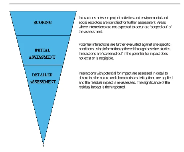
The following diagram (Figure 3.2) describes the impact identification and assessment process through scoping, screening and detailed impact
assessment. The methodology for detailed impact assessment is outlined in
Section 3.5.2 below.
Figure 3.2 Impact Assessment Process
3.5.2 Impact Assessment Methodology
The purpose of impact assessment and mitigation is to identify and evaluate the significance of potential impacts on identified receptors and resources according to defined assessment criteria and to develop and describe
measures that will be taken to avoid or minimise any potential adverse effects and to enhance potential benefits.
Definition of Key Terminology
x Project - The features and activities that are a necessary part of the Project Proponent’s development, including all associated facilities without which the Project cannot proceed. The Project is also the
SCOPING
SCREENING
DETAILED ASSESSMENT
Interactions between project activities and environmental and social receptors are identified for further assessment. Areas where interactions are not expected to occur are ‘scoped out’ of the assessment.
Potential interactions are further evaluated against site-specific conditions using information gathered through baseline studies. Interactions are ‘screened out’ if the potential for impact does not exist or is negligible.
Interactions with potential for impact are assessed in detail to determine the nature and characteristics. Mitigations are applied and the residual impact is re-assessed. The significance of the residual impact is then reported.
collection of features and activities for which authorization is being sought.
x Project Site - The (future) primary operational area for the Project activities. Private transport corridors (ie, those dedicated for use solely by Projectoperational activities) are included as part of the Project Site.
x Project Footprint - The area that may reasonably be expected to be physically touched by Project activities, across all phases. The Project Footprint includes land used on a temporary basis such as construction lay down areas or construction haul roads, as well as disturbed areas in transport corridors, both public and private. Note that for the purposes of this Project the Project Footprint will be referred to as the PV Footprint.
Impact Types and Definitions
An impact is any change to a resource or receptor brought about by the presence of a project component or by the execution of a project related activity. The evaluation of baseline data provides crucial information for the process of evaluating and describing how the project could affect the bio-physical and socio-economic environment.
Impacts are described according to their nature or type, as summarised in
Table 3.3.
Table 3.3 Impact Nature and Type
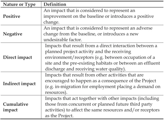
Nature or Type Definition
Positive An impact that is considered to represent an improvement on the baseline or introduces a positive change.
Negative
An impact that is considered to represent an adverse change from the baseline, or introduces a new undesirable factor.
Direct impact
Impacts that result from a direct interaction between a planned project activity and the receiving
environment/receptors (e.g. between occupation of a site and the pre-existing habitats or between an effluent discharge and receiving water quality).
Indirect impact
Impacts that result from other activities that are encouraged to happen as a consequence of the Project (e.g. in-migration for employment placing a demand on resources).
Cumulative impact
Impacts that act together with other impacts (including those from concurrent or planned future third party activities) to affect the same resources and/or receptors as the Project.
Assessing Significance
Impacts are described in terms of ‘significance’. Significance is a function of the magnitude of the impact and the likelihood of the impact occurring. Impact magnitude (sometimes termed severity) is a function of the extent, duration and intensity of the impact. The criteria used to determine
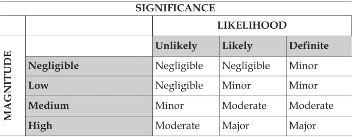
significance are summarised in Table 3.4. Once an assessment is made of the magnitude and likelihood, the impact significance is rated through a matrix process as shown in Table 3.5 and Table 3.6.
Significance of an impact is qualified through a statement of the degree of confidence. Confidence in the prediction is a function of uncertainties, for example, where information is insufficient to assess the impact. Degree of confidence is expressed as low, medium or high.
Table 3.4 Significance Criteria Impact Magnitude
Extent
On-site – impacts that are limited to the boundaries of the development site.
Local– impacts that affect an area in a radius of 20km around the development site.
Regional– impacts that affect regionally important environmental resources or are experienced at a regional scale as determined by administrative boundaries, habitat type/ecosystem.
National– impacts that affect nationally important environmental resources or affect an area that is nationally important/ or have macro-economic consequences.
Duration
Temporary – impacts are predicted to be of short duration and intermittent/occasional.
Short-term– impacts that are predicted to last only for the duration of the construction period.
Long-term– impacts that will continue for the life of the Project, but ceases when the project stops operating. Permanent– impacts that cause a permanent change in the affected receptor or resource (e.g. removal or destruction of ecological habitat) that endures substantially beyond the project lifetime.
Intensity
BIOPHYSICAL ENVIRONMENT: Intensity can be
considered in terms of the sensitivity of the biodiversity receptor (i.e. habitats, species or communities).
Negligible – the impact on the environment is not detectable.
that natural functions and processes are not affected. Medium – where the affected environment is altered but natural functions and processes continue, albeit in a modified way.
High – where natural functions or processes are altered to the extent that they will temporarily or permanently cease.
Where appropriate, national and/or international standards are to be used as a measure of the impact. Specialist studies should attempt to quantify the magnitude of impacts and outline the rationale used.
__________________________________________________
SOCIO-ECONOMIC ENVIRONMENT: Intensity can be
considered in terms of the ability of people/communities affected by the Project to adapt to changes brought about by the Project.
Negligible – there is no perceptible change to people’s livelihood.
Low - people/communities are able to adapt with relative ease and maintain pre-impact livelihoods. Medium – people/communities are able to adapt with some difficulty and maintain pre-impact livelihoods but only with a degree of support.
High - affected people/communities will not be able to adapt to changes or continue to maintain-pre impact livelihoods.
Likelihood - the likelihood that an impact will occur Unlikely The impact is unlikely to occur.
Likely The impact is likely to occur under most conditions. Definite The impact will occur.
Once a rating is determined for magnitude and likelihood, the following matrix can be used to determine the impact significance.
Table 3.5 Significance Rating Matrix SIGNIFICANCE LIKELIHOOD MA GN ITU D
E Unlikely Likely Definite
Negligible Negligible Negligible Minor
Low Negligible Minor Minor
Medium Minor Moderate Moderate
High Moderate Major Major
Table 3.6 Significance Colour Scale
Negative ratings Positive ratings
Negligible Negligible
Minor Minor
Moderate Moderate
Major Major
Table 3.7 Significance Definitions
Significance definitions Negligible
significance
An impact of negligible significance (or an insignificant
impact) is where a resource or receptor (including people) will not be affected in any way by a particular activity, or the predicted effect is deemed to be ‘negligible’ or ‘imperceptible’ or is indistinguishable from natural background variations. Minor
significance
An impact of minor significance is one where an effect will be experienced, but the impact magnitude is sufficiently small (with and without mitigation) and well within accepted standards, and/or the receptor is of low sensitivity/value. Moderate
significance
An impact of moderate significance is one within accepted limits and standards. The emphasis for moderate impacts is on demonstrating that the impact has been reduced to a level that is as low as reasonably practicable (ALARP). This does not necessarily mean that ‘moderate’ impacts have to be reduced to ‘minor’ impacts, but that moderate impacts are being managed effectively and efficiently.
Major significance
An impact of major significance is one where an accepted limit or standard may be exceeded, or large magnitude impacts occur to highly valued/sensitive resource/receptors. A goal of the EIA process is to get to a position where the Project does not have any major residual impacts, certainly not ones that would endure into the long term or extend over a large area. However, for some aspects there may be major residual
impacts after all practicable mitigation options have been exhausted (i.e. ALARP has been applied). An example might be the visual impact of a development. It is then the function of regulators and stakeholders to weigh such negative factors against the positive factors such as employment, in coming to a decision on the Project.
Once the significance of the impact has been determined, it is important to qualify the degree of confidence in the assessment. Confidence in the prediction is associated with any uncertainties, for example, where
information is insufficient to assess the impact. Degree of confidence can be expressed as low, medium or high.
Mitigation Measures and Residual Impacts
For activities with significant impacts, the EIA process is required to identify suitable and practical mitigation measures that can be implemented. The implementation of the mitigations is ensured through compliance with the Framework Environmental Management Programme (EMPr). After first assigning significance in the absence of mitigation, each impact is re-evaluated assuming the appropriate mitigation measure(s) is/are effectively applied, and this results in a significance rating for the residual impact.
3.6 IDENTIFICATION OF MITIGATION MEASURES
For the identified significant impacts, the project team, with the input of the client, has identified suitable and practical mitigation measures that are implementable. Mitigation that can be incorporated into the project design, in order to avoid or reduce the negative impacts or enhance the positive impacts, have been defined and require final agreement with the client as these are likely to form the basis for any conditions of approval by DEA.
3.7 SPECIALIST STUDY METHODOLOGY
3.7.1 Botany, Terrestrial Ecology and Avifauna
A botany, terrestrial ecological and avifaunal specialist study was undertaken by Simon Todd of Simon Todd Consulting (see Annex F). As part of this study, a desktop study was carried out of publicly available scientific
publications to investigate the ecology and biodiversity of the affected project area. A site visit was undertaken where the different biodiversity features, habitat, vegetation and landscape units present at the site were identified and mapped in the field. This included generating a fine-scale vegetation map for the site which identified and mapped the different plant communities present. Walk-through-surveys were conducted across the site and all plant and
plant species at the site were conducted and the location of all listed plant species observed was recorded using a GPS. Active searches for reptiles and amphibians were also conducted within habitats likely to harbour or be important for such species. The presence of sensitive habitats such as
wetlands or pans and unique edaphic environments such as rocky outcrops or quartz patches were noted in the field if present, recorded on a GPS and mapped onto satellite imagery of the site. The impact assessment phase involved the determination of the nature of likely impacts of the development and recommendations on mitigation.
3.7.2 Archaeology, Heritage and Palaeontology
A palaeontological, archaeological and cultural heritage specialist study, as described below, was undertaken by Tim Hartand Liesbet Schietecatte of ACO Associates and Graham Avery (see Annex G).
Palaeontology
A desktop palaeontological study was undertaken for the Site. The 1:250 00 Geological Series 3318 Cape Town map was consulted for background
information. The focus was to illustrate the potential of sub-surface sediments through the geological context and observations in the general vicinity. The impact assessment phase involved the determination of the nature of likely impacts of the development and recommendations on mitigation.
Archaeology
A desktop study was carried out of publicly available scientific publications to determine the archaeological history of the affected project area. In addition, an archaeological field survey was undertaken of the affected project area. Archaeological materials and structures were inventoried, with GPS positions, with approximate age and descriptions recorded as necessary. No
archaeological material was removed from the project area, but recorded and photographed in situ. The impact assessment phase involved the
determination of the nature of likely impacts of the development and recommendations on mitigation.
Heritage
Publications of the history of the affected project area were investigated and informed the specialist study. A heritage field survey was undertaken in order to identify existing heritage structures in the affected project area. These heritage structures were inventoried, with their GPS positions, age and
descriptions recorded. The impact assessment phase involved the determination of the nature of likely impacts of the development and recommendations on mitigation.
3.7.3 Landscape and Visual
A landscape and visual impact assessment study was undertaken by Stephen Stead of VRM Africa (see Annex H). A site visit was undertaken where visual features and the landscape setting of the site were recorded. An assessment was also made as to what degree people who make use of these locations (e.g. a nearby holiday resort) would be sensitive to change(s) in their views,
brought about by the Project. These receptors were then identified, as well as Key Observation Points (KOPs) (those sensitive receptors who had views of the Project) particularly those relating to intersections of major roads, arterial and scenic routes, as well as urban areas, settlements and farmsteads. The landscape character was then surveyed in terms of scenic quality (landscape significance) and receptor sensitivity to landscape change (of the site) in order to define the visual objective for the project site. Photomontages using panoramic photographs were used to determine the degree of visibility of the Project and change in views of the surrounding landscape. The impact assessment phase involved the determination of the nature of likely impacts of the development and recommendations on mitigation.
3.7.4 Agriculture
An agriculture impact assessment study was undertaken by Kurt Barichievy of SiVest engineering (see Annex I). A detailed desktop assessment was undertaken for the Drennan Site and surrounds land. The objective of this study was to broadly evaluate the soil and land use of the sites and receiving environment by interrogating relevant climate, topographic, land-use and soil datasets. By utilising the available data resources the relevant specialist was able to broadly assess the current soil, agricultural and land use characteristics and provide a basis for a more detailed and spatially relevant assessment. Furthermore a detailed soil survey was conducted for the Drennan Site. At each sample point a hand auger was used to identify and describe the diagnostic horizons to form and family level according to the Soil
Classification Working Group (1991). The soil characteristics such as depth, texture and limiting layers were also noted. At each auger point the relevant soil and land use data was recorded and the location of the auger point captured using a handheld GPS. This information was combined to produce detailed soil polygon and soil depth maps.
The agricultural potential of the site was also determined. The soil information gained from the survey along with the land use assessment was combined with climate, water resource, crop information and topographic data in order to provide a spatial classification of the land based on its agricultural
potential. A study of local agricultural practices was also carried out. Finally the impact assessment utilised the findings of the soil survey and agricultural potential assessment in order to determine reference conditions of the soil and agricultural resources. Potential soil and agricultural impacts, as a
result of the proposed activities, were described and any major impacts/fatal flaws identified for consideration by the pertinent authorities.
3.7.5 Socio-economic
The socio-economic specialist study was undertaken by ERM social specialists, Lindsey Bungartz and Mischa Minné (see Annex J for the Social Specialist Declaration of Independence). The study began with the compilation of a baseline description. The baseline description was derived from a range of secondary data (including but not limited to census data, existing reports, development plans and other strategic planning documents) and primary data collection. The primary data used for the baseline is based on information provided by the directly-affected landowners and issues raised through the public consultation process.
The impact assessment phase incorporated the identification and assessment of socio-economic impacts (direct, indirect and cumulative) that may result from the construction and operation phases of the project. Mitigation
measures that address the local context and needs were recommended as the final phase of the study.
Geotechnical and Geohydrological Reports
At this stage of the project detail geotechnical studies have yet to be
undertaken. A detailed geotechnical report is not deemed necessary for this environmental and social impact assessment to be completed. Likewise, a detailed geohydrological study is not deemed necessary for this
environmental and social impact assessment to be completed. Potential impacts of groundwater, surface water and erosion are assessed in Chapter 7.
3.8 ASSUMPTIONS AND LIMITATIONS
Environmental Impact Assessment is a process that aims to identify and anticipate possible impacts based on past and present baseline information. As the EIR deals with the future there is, inevitably, always some uncertainty about what will actually happen in reality. Impact predictions have been made based on field surveys and with the best data, methods and scientific knowledge available at this time. However, some uncertainties could not be entirely resolved. Where significant uncertainty remains in the impact assessment, this is acknowledged and the level of uncertainty is provided. In line with best practice, this EIR has adopted a precautionary approach to the identification and assessment of impacts. Where it has not been possible to make direct predictions of the likely level of impact, limits on the maximum likely impact have been reported and the design and implementation of the project (including the use of appropriate mitigation measures) will ensure that these are not exceeded. Where the magnitude of impacts cannot be predicted with certainty, the team of specialists have used professional experience and available scientific research from solar facilities worldwide to judge whether a
significant impact is likely to occur or not. Throughout the assessment, this conservative approach has been adopted to the allocation of significance.
3.8.1 Gaps and Uncertainties
Inevitably knowledge gaps remain. For instance, there is an incomplete understanding of cumulative impacts as it is not known how many of the proposed solar power facilities in the vicinity of the Site will be granted authorisation and selected as projects in the IPP procurement process.
Gaps in Project Description
x Regarding the location of solar arrays, the assessment is based on a preferred and refined layout derived from revisions of earlier layouts, to accommodate environmental sensitivities. Although the final layout has been confirmed, the precise locations of the solar arrays may be subjected to fine-scale siting that would allow for more detailed geotechnical studies. This will also seek to ensure that all locations remain in areas of low sensitivity as defined by this study and that the specialists will sign off the revised positions.
x At this stage it is unknown, although unlikely, whether a borrow pit for rock or soil material will be required for the construction of project infrastructure.
Gaps in Baseline Information
x Ecological limitations; a limitation associated with the sampling approach was the narrow temporal window of sampling. Ideally, a site should be visited several times during all the different annual seasons to ensure that the full complement of plant and animal species present are captured. However, this is rarely possible due to time and cost constraints and therefore, the data captured is representative of the species at the site. The vegetation at the time of the site was in a reasonable condition for
sampling. Although a full plant species list was compiled for the site from the site visit, this was complemented by a list of any listed species which are known from other studies to occur in the broad vicinity of the site. The lists of amphibians, reptiles and mammals for the site are based on those observed at the site as well as those likely to occur in the area based on their distribution and habitat preferences. This represents a sufficiently conservative and cautious approach which takes account of the study limitations.
Gaps in Understanding of Impacts
x It should be noted that as large scale solar power facilities are new to South Africa, the impacts associated with them have not been scientifically researched in the context of their occurrence in this country, and therefore the specialists have used the precautionary principal where necessary in undertaking their respective impact assessments.