i
KENYATTA UNIVERSITY
SCHOOL OF ENVIRONMENTAL STUDIES
DEPARTMENT OF ENVIRONMENTAL PLANNING AND
MANAGEMENT.
THE POTENTIAL OF ROOF CATCHMENT AS A FLOOD MANAGEMENT STRATEGY AT MAVOKO SUB-COUNTY IN MACHAKOS COUNTY.
BY
CHRISTINE MUSYAWA NDONYE.
N36/2785/2010
A RESEARCH PROJECT SUBMITTED IN PARTIAL FULFILLMENT OF
REQUIREMENTS FOR THE AWARD OF A BACHELOR’S DEGREE COURSE IN ENVIRONMENTAL PLANNING AND MANAGEMENT.
ii
DECLARATION.
This research study is my original work and has not been presented to any other examination
body. No part of this research should be reproduced without my consent or that of The Kenyatta
University.
Christine Musyawa
N36/2785/2010
Signature_______________ Date _____________
Declaration by the Supervisor
This research has been submitted with my approval as the Kenyatta University Supervisor.
Mr. Kirui
iii
DEDICATION
This work is dedicated to Kenyatta University; Department of Environmental Planning and
iv
ACKNOWLEDGEMENT
First and foremost, I would like to express my deepest appreciation to God for availing the
opportunity to carry out the Research Project. I also wish to thank the Department of
Environmental Planning and Management for their support throughout this research. Their
support has been invaluable to the completion of the field work and this report. I am grateful to
Mr. Alan Kirui for guiding and advising me on this project and for his availability for
consultation during the entire period, patience and assistance in developing this study.
My gratitude goes to the residents of Mavoko sub-county for giving me an opportunity to
administer questionnaires in their homes and undertake focus group discussions for taking their
time to answer my questions based on the study. I also thank institutions such as WRMA,
WRUA’s as well as other institutions back in Machakos that provided information and
background data.
Finally, my sincere thanks go to my fellow colleagues and my family for their unconditional
v ABSTRACT
The traditional approach for coping with urban flooding has been linear whereby all the
rainwater that has fallen over a wide area is conveyed to and managed by sewers or rivers lines.
When the carrying capacity is insufficient, possible counter measures are considered only to the
line; denoting the upsizing of the sewer, widening of the rivers or increasing the pumping
capacity. Due to heavier and unpredictable rainfall, the water conveyance system in the whole
sub-county is limited, thus requiring upgrading of another method of containing the excess
water.
The water management approach worldwide is currently in transition, with a shift evident from
purely centralised infrastructure to greater consideration of decentralised technologies, such as
rainwater harvesting (RWH). Initiated by recognition of drivers including increasing water
demand and increasing risk of flooding, the value of RWH is beginning to filter across the
academic-policy boundary. However, in Kenya, implementation of RWH systems is not straight
forward due to social and technical barriers, concerns and knowledge gaps exist, which currently
restrict its widespread utilisation. (Ward, S., Butler, D., Barr, S. and Memon, F.A. 2009)
Rainwater harvesting as a supplementary source of water has not received any serious attention.
This research investigates the potential of roof catchment collection, storing and using rainwater
in Mavoko sub-county, Machakos County.
The importance of this study lies in severe flooding in some areas of Mavoko particularly in its
satellite town which are experiencing rapidly population and development growth in the
sub-county. So many people are affected when floods occur and furthermore the current water supply
vi
Mavoko has a tropical climate, with rainy months from March to May and October to December,
with approximately 118 days of rain in the year and an annual precipitation of 40 inches (Kenya
Meteorology Department, 2011). Considering the chronic water scarcity in the sub-county, a
considerable amount of homes have elevated or underground water storage tanks installed to
provide water for their daily use. These two observations make rainwater catchment systems a
great option to be considered because the approach takes advantage of the opportunities the
vii List of figures.
Figure 2.1: Theoretical Framework………….……….24
Figure 2.2: Conceptual Framework……….26
Figure 3.1: Location map of Mavoko Sub-county………….………..29
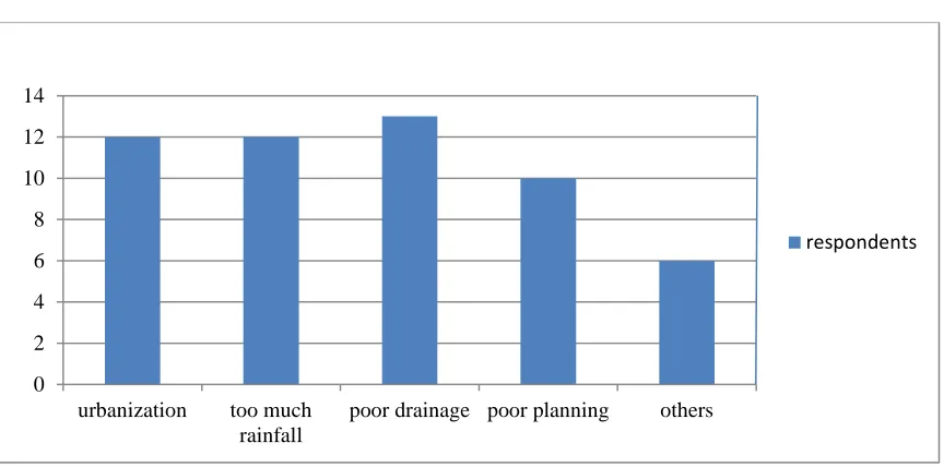
Figure 5.1: Major causes of floods in Mavoko sub-county………..47
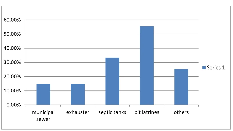
Figure 5.2: Methods of sanitation disposal………..……….50
Figure 5.3: Percentages of persons displaced by floods………...51
Figure 5.4: Different roofing materials………..52
Figure 5.5: Percentages of water users in different sources of water………54
Figure 5.6: Water bill……….55
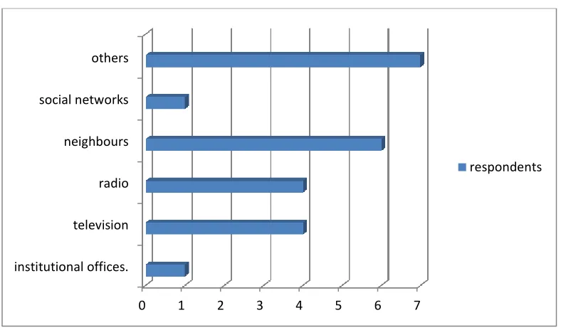
Figure 5.7: Sources of disaster information………...56
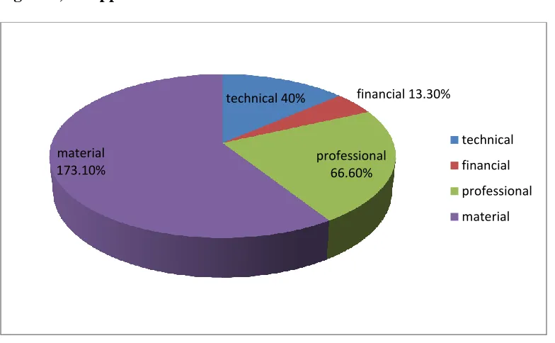
Figure 5.8: Support received from disaster related institutions……….57
Figure 5.9: Effectiveness of the relevant institutions……….58
viii ACRONYMS
ADC- African District Council
DEAP- District Environmental Action Plan.
DMCs- Disaster Management Committees.
DOC- Disaster Operations Centers.
IWRM- Integrated Water Resource Management.
LNC- Local Native Council.
KMD- Kenya Meteorological Department.
KRA- Kenya Rainwater Association.
MDGs- Millennium Development Goals.
MWI- Ministry of Water and Irrigation.
NLM- New Life Mission.
RHM- Rainwater Harvesting and Management.
RWH- Rain Water Harvesting.
WASREB- Water Services Regulatory Board
WRM- Water Resource Management.
WRUAs- Water Resource Users Associations.
ix
Table of Contents
DECLARATION. ... i
DEDICATION ... iii
ACKNOWLEDGEMENT ... iv
ABSTRACT ... v
List of figures. ... vi
Acronyms ... viii
Operational terms ... xiv
Chapter Outlines ... xv
CHAPTER ONE: ... 1
1.1 Background of the study. ... 1
1.2 Problem statement. ... 3
1.3. Research questions. ... 4
1.4. Research objectives. ... 4
1.5. Research premises. ... 4
1.6. Justification. ... 5
1.7. Significance of the study. ... 7
1.8. Scope of the study. ... 7
x
CHAPTER TWO. ... 10
LITERATURE REVIEW ... 10
2.1 Introduction. ... 10
2.2 Causes of Floods. ... 10
2.3 The Consequences of Floods... 12
2.4 The Potential of Roof Catchment. ... 14
2.4.1. Existing rainwater harvesting projects. ... 15
2.5 Institutional Capacity. ... 17
2.5.1 Ministry Of Water and Irrigation. ... 17
2.5.2 Water Act, 2002. ... 18
2.5.3 Kenya Rainwater Association (KRA). ... 19
2.5.4 Disaster Management. ... 19
2.5.5 Case study. Nairobi national museum, Nairobi- Kenya ... 20
2.5.6 Level of institutional Involvement ... 20
2.5.7 Community participation. ... 21
2.6 Gap Identification in the Existing Literature... 22
2.7 Theoretical Framework. ... 22
2.8 Conceptual Framework. ... 24
xi
AREA OF STUDY. ... 27
3.1 Introduction ... 27
3.2. The physical set up. ... 27
3.2.1. Location and extent. ... 27
3.2.2. Topography and drainage. ... 30
3.2.3. Geology and soils. ... 31
3.2.4. Climate and physical features. ... 33
3.3Ecological set up. ... 33
3.3.1. Vegetation and soils... 33
3.3.2. Wildlife. ... 34
3.4. The economical set up. ... 34
3.4.1. Agriculture. ... 34
3.4.2. Trade and commerce and industry. ... 35
3.4.3. Transport and communication. ... 36
3.5. Social set up ... 36
3.5.1. Population. ... 36
3.5.2. Housing. ... 37
3.5.3. Archeology and cultural heritage ... 38
CHAPTER FOUR. ... 40
xii
4:1. Introduction. ... 40
4.2. Research Design. ... 40
4.3. Nature and Sources of the Data. ... 40
4.3.1. Primary Data Sources ... 41
4.4. Population Description. ... 41
4.5. Sampling Methods... 41
4.5.1. Sample Size ... 41
4.6. Method of Data Collection. ... 42
4.6.1. Primary data collection. ... 42
4.6.2. Secondary data collection instruments ... 43
4.6.3. Data Collection Process ... 44
4.7. Data Analysis and Presentation ... 44
4.8. Reliability and Validity ... 45
CHAPTER FIVE. ... 46
DATA PRESENTATION, ANALYSIS AND DISCUSSION. ... 46
5.1 Introduction. ... 46
5.2 Profile of the respondents. ... 46
5.3 Consequences of the floods. ... 48
5.4 Potential of roof catchment. ... 53
xiii
CONCLUSION AND RECOMMENDATIONS. ... 60
6.1 Summary of the findings. ... 60
6.2 Conclusion. ... 60
6.3 Recommendations. ... 61
6.4 Areas for further study. ... 62
REFERENCES. ... 64
Appendices A. ... 66
Appendices B. ... 71
Appendices C. ... 73
xiv
Operational terms.
Aquifer- underground formation / soil/ rock which can yield water.
Artificial recharge- any man made scheme of facility that adds water to an aquifer.
Bore well- small diameter wells which are generally deeper than open wells.
Catchment area-
Dug wells- traditionally used large diameter wells. A pit excavated in the ground until the
water table is reached. Usually supported on sides by brick or stone wall.
Ground water- the water retained in the inter-granular pores of soil or fissures of rock
below the water table.
Rainwater harvesting- the capturing of rainwater before it reached the ground and its
storage on tanks for its use. Is also the deliberate collection of rainwater from a surface
(catchment) and store it to provide a water supply.
Run off- water flowing on the surface after a long rain within.
Recharge- the process of surface water percolating naturally to the ground
Water table- the level of water within it granular pores of soil or fissures of rock, below
xv
Chapter Outlines
Chapter one gives an in-depth overview of the background to the problem, statement of the
problem research questions, objectives, premises significance, and justification of the study and
the scope of the study.
Chapter Two provides a critical review of the existing relevant literature, culminating in the
identification of gaps and the conceptual framework.
Chapter Three outlines the area of study in terms of its physical and socio-economic set up.
Chapter Four discusses the research methodology, focusing on the nature of data, sampling
procedures and methods of data collection and analysis.
Chapter Five deals with data analysis and discussions and finally;
1
CHAPTER ONE:
INTRODUCTION.
1.1 Background of the study.
Among the natural phenomena, flood is one of the biggest destroying factors in developing
countries which always bring numerous people's life, property and assets to the hazard. The
growing population, urban development and industrialization are the main factors that have
undesirable consequences in the hydrology of watershed region in the cities. developing
countries experience urban flood during rain seasons due to the limited water percolation to the
earth’s surface as a result of impermeable surface which a has been introduced by man. It is
therefore tangible that we require some construction of transition and collection of surface runoff
and integrated management to reduce the flood (Ngigi, 2003:944).
According to Singh et al (2005:214), Water-related disasters such as floods, droughts and water-
borne diseases affect more than 200 million people each year and claim more lives than war. The
damage done by water-related disasters thwarts sustainable development and perpetuates
poverty. Over the last 10 years, disasters of hydrological, meteorological and climatic origin
have been responsible for over 90% of all deaths due to natural disasters. More than 2,000
water-related disasters on all scales occurred during the last decade. Asia and Africa were the most
affected continents, with floods accounting for half of these disasters and water-borne and
vector-disease outbreaks accounted for a significant fraction of remaining disasters. In term of
2
According to RELMA, (2007), Africa is considered a water-scarce continent with most of
countries regularly experiencing extreme water shortage during periodic dry spells. Rapid
population growth and inefficient use of resources increases the deficit between available
supplies of water and the needs of the people.
As a resource dwindle and water demand increases, large scale water supply projects become
unviable. There is need to decentralize water supply to household and small community level.
There is great potential to make better use of water resources by harvesting rainwater and storing
it locally for household and productive purposes (ibid, 2007).
The lack of water is the largest constraints to sustainable livelihoods in many parts of Africa.
Rapid runoff during the rainy season frequently results in a high proportion going to waste or
even becoming destructive. Harvesting rainwater where and when it falls presents opportunities
to address both water scarcity and floods at local level (Vohland & Barry, 2009: 120).
Many cities in Kenya, especially Nairobi suffers from the same malady. Nairobi is blessed with
two monsoon seasons and receives more than 1000mm of rain spread out comfortably across the
year, yet if suffers from severe water shortage. Flooding in Nairobi has become an annual ritual
causing deaths and massive destruction. Eleven people were killed by floods in Nairobi in 2001;
exact numbers of the people who drowned not confirmed and 21 more people have been
drowned in flood waters since then (Anon, 2000).
Mavoko sub-county also faces regular floods which when they occur brings the area to a
standstill. Crossing roads during the rain seasons becomes impossible especially in areas with
marrum roads making rains in this area are more of menace than a relief. Rain water is allowed
3
The rainwater harvesting in Mavoko sub-county can serve dual purpose of controlling floods and
reducing water scarcity. If the rainwater harvesting potential in this area is utilized optimally it
would be possible to meet as much as 42% of the water demand.
1.2 Problem statement.
Floods have been major problems to residents of Mavoko sub-county. Every time it rains the
area is full of floods, life are disrupted, dirty and unhealthy as rain water mixes with sewer waste
from sewer lines, septic tanks, and soaks pits and flows through the rapidly upcoming residential
and industrial areas. Rain literally becomes a curse but once rain and the water logging are far
behind the same area will be thirst again
The rapid expansion of the town has led to sealing off of large surface areas, increasing the speed
and volume of storm water run-off. Furious flooding damages property, consumes people’s lives,
exposes and damages water pipelines and chokes drainage channels with debris, spilling raw
sewage into the streets which has health implications such as cholera. As a result of increasing
surface cover, rain water is prevented from percolating into the ground. Some of the town
residents have opted for boreholes as an alternative to the intermittent water supply. However the
boreholes are now experiencing inadequate yields due to poor recharge of the water table. The
urban-industries, residential and commercial sectors demand for water is growing by leaps and
bounds yet these sectors do little to augment its water resources. Therefore this research tries to
answer the question that why rain has become a curse in Mavoko sub-county by assessing the
4 1.3. Research questions.
The main questions of this study will be; how can rainwater be effectively utilized to reduce
flooding in Mavoko sub-county.
The following specific questions will arise to answer this main question.
a) What are the causes of floods in Mavoko sub-county?
b) What are consequences of floods in Mavoko?
c) What is the potential of roof catchment as a flood management strategy?
d) Do the relevant institutions have the capacity of supporting roof catchment?
1.4. Research objectives.
The main objective of this research is to propose measures that can be effectively used to curb
flooding of Mavoko sub-county.
a) To assess the causes of flooding Mavoko sub-county.
b) To examine the consequences of flooding in Mavoko.
c) To assess the potential of roof catchment to address flooding in Mavoko.
d) To evaluate the institutional capacity to support roof catchment as a flood management
strategy.
e) To recommend appropriate measures of managing floods in Mavoko.
1.5. Research premises.
a) Rapid urbanization is the cause of floods in Mavoko sub-county.
b) Floods have no consequences in Mavoko area.
c) Roof catchment has no potential as a flood management strategy.
5 1.6. Justification.
Water is an integral part of ecosystems functioning as its presence or absence has a bearing on
the ecosystems services it provides. Relatively larger amount of water is used to generate the
ecosystem services needed to ensure provisioning of basic supplies of food, fodder and fibers.
Today rainfed and irrigated agriculture use 7,600 litres of freshwater globally to provide food.
During the 2000 UN Millennium Summit, world leaders from developed and undeveloped
countries committed themselves to eight time-bound goals as a blue print to accelerate
development. The resultant plan is set forth in the Millennium Development Goals (MDGs).
Goal 7 of MDG addresses the environment and water with targets that provide the goal to
“halve, by 2015, the proportion of the population without sustainable access to safe drinking
water and basic sanitation”. In relation to water, this implies provision of safe water for drinking
as well as for hygiene. Therefore roof catchment it plays a critical role in meeting the millennium
development goals, especially those concerning hunger, poverty, health and biodiversity. An
additional of 1,600 km3 of water is required annually to meet the millennium development goal
on hunger reduction which addresses only half of the people suffering from hunger. (Jennie
Barron, 2009).
In the present scenario management and distribution of water has become centralized. People
depend on government system, which has resulted in disruption of community participation in
water management and collapse of traditional water harvesting system. As the water crisis
continues to become severe, there is a dire need of reform in water management system and
revival of traditional systems. Scientific and technological studies need to be carried out to assess
6
Mavoko sub-county acts as a dormitory for the people working in Nairobi, Machakos, Kajiado
County among other counties contributing to increased human population and rapid residential,
commercial and industrial developments have led to increased paved area which reduces the rate
of water percolating to the ground resulting to floods which causes massive losses in terms of
life, property, destruction of settlement, facilities and agricultural products and economic burden
to the community, also flooding water carries with it sewerage waste from default sewer lines
which has health effect on people, causes siltation of water bodies and deposition of invasive
plant species. Therefore there is need to manage flooding in order to be able to stabilize the
sub-counties economy, reduce massive deaths and health effects, increase agricultural production and
reduce damage of settlement and other facilities.
Mavoko area receives plenty of rain as it is blessed with rain regime, the long rains during April
to June and the short rains between October and December. It receives an average rainfall of
750mm. in spite of this, the sub-county faces water shortage, which is attributed the fact that the
sub-county acts as a dormitory for workers in Nairobi and other nearby centers such as
Machakos town contributing to the current population of 137,211 people making it almost
impossible for the sub-county to adequately meet the escalating water demand. Also many areas
in Mavoko sub-county depend on borehole water and an average of 3500 cubic meter of water is
extracted daily, leading to a decline in groundwater level (Machakos DEAP 2009-2013). Water
harvesting will provide means of recharging ground water thereby maintaining the balanced
situation of the resource.
This project done now will help in preventing floods in low lying areas, replenishing of ground
7
during summer seasons and help in the availability of clean water with reduced salinity and
presence of iron salts.
1.7. Significance of the study.
The beneficiaries of this study are the residents of Mavoko Sub-County, real estate and industrial
owners who for the past years have encountered great losses as a result of floods. The
beneficiaries also will be able to augment the water supplied MAVWASCO during dry season
when there is water rationing and also reduce water bills.
There are numerous positive benefits for harvesting rainwater. The technology is low cost,
highly decentralized empowering individuals and communities to manage their water. It has been
used to improve access to water and sanitation at the local level. In agriculture rainwater
harvesting has demonstrated the potential of doubling food production by 100% compared to the
10% increase from irrigation.
1.8. Scope of the study.
Mavoko sub-county covers an area of 693 km², with an average population of 137,211.
Stretching from KAPA/Airport area where it borders with Nairobi County and covers Katani,
Ruai on Kangundo road through Muthwani-Lukenya, Makutano (Kyumbi) where it Borders
Machakos Town. It covers Kapiti plains to the south west towards Kitengela area where it
borders with Kajiado County, then to Embakasi at Nairobi County border. (USAID, Kenya).
This study focuses on the potential of roof top catchment as a strategy to control floods in
Mavoko sub-county. The study will cover the following satellite towns in which hosts half of the
population of the sub-county with a population of 111,742 (Machakos DEAP, 2009-2013)
8 1.9. Limitation.
Time,
Time has always been a limited factor, especially due to the fact that rainwater harvesting has not
been being practiced; it might take long to gather enough data for research.
Inaccessibity.
Mavoko area has black cotton soil which is inaccessible especially during the rain seasons. Some
areas of Mavoko sub-county have no defined access roads.
Inadequate information.
The meteorological department might not be willing to give information and data regarding the
amount and frequency of rainfall received in the area.
Also the community might not be willing to discuss anything related to floods maybe because it
reminds them of hoe they suffer every time it occurs, loss of their loved ones or loss of hope in
mitigation of this disaster.
Hostile community.
Community not willing to give information as they believe nothing can be done to help their
situation. They argue that so many researches have been done in the past and so far no solutions
9
The following measures were taken to address the above challenges. In order to be able to save
time I conducted reconnaissance before to familiarize myself with the areas and that made it
easier to traverse the area, use of gumboots which made it possible to navigate the muddy roads.
As it was not possible to get all the information necessary for the research from meteorological
department and the community published information such as DEAPs and internet were used to
fill in the gap and lastly, I was able to convince the community who are the key beneficiaries of
10
CHAPTER TWO.
LITERATURE REVIEW.
2.1 Introduction.
Roof catchment has been practiced over the past 2000 years. The earliest evidence in Africa
relates to cisterns in the western Mediterranean Coastal Desert in Egypt which date back to
roman times. At present 2000-3000 cisterns in the region are still operational with their sizes
ranging from 200-300 cubic meters (Shata, 1982). Tradionally, people have collected and stored
rainwater running from eaves of their thatched roofs in earthenware pots.
Along the east coast of Africa, rainwater collection systems known locally as djabias have been
constructed in several countries and are still in used until today. For example, in Manda, Pate and
Wasini islands in coastal region of Kenya. These consist of rectangular tanks made of coral
blocks and were traditionally plastered with local cement made from burning and crushing coral.
These systems often had a small purpose-built catchment area to complement roof run off. By
the first half of 20th century, roof catchments were often build at missions, churches and in
schools (ibid, 1982).
2.2 Causes of Floods.
There are numerous types and causes of floods which include; urban flooding is caused by
rainfall overwhelming drainage capacity in urban areas, the impact can be very high because the
areas affected are densely populated and contain vital infrastructure. Continuing development in
flood-prone areas increases the risk.
Future Flooding, Foresight OST, (2004) states that, the cost of urban flooding could rise to
11
The following factors tend to be the cause of increased urban flood; Ageing drainage
infrastructure- where by a lot of sewerage and drainage network is old and in poor condition,
more buildings- the development of new structures cover previously permeable ground
increasing the amount of surface water running off into drainages and sewers, Increased paving-
increasing proportions of impermeable ground in existing developments as people build patios
and pave over front gardens, and lastly, climate change- wetter winter and heavier summer
shower are expected to put more pressure on urban drainage. Climate models predict that winter
rainfall will increase by 20-30% by 2080s.
Natural floods: This type of floods is caused naturally by overflow of huge volume of water from
rivers, lakes, coastal or heavy rains or downpours, tsunamis and hurricanes. They could be
riverine floods caused by rivers. Estuarine floods caused by a combination of sea tidal surges and
storm-forces winds or coastal floods caused by tsunamis and cyclones.
Catastrophic floods: This type of floods is caused by significant or unexpected events such as
dam breakages. Heavy rains causes rise of water levels in dams, rivers, lakes and water starts to
overflow to the adjoining areas causing deluge.
Snow floods: floods caused by snow melting as global temperature rises as a result of global
warming making the snow caps to melt faster. Continuous and faster snow melting and rises the
level of oceanic water which consequently raises the level of water in rivers causing floods.
The satellite towns majorly experience urban floods due to the increased paved areas, natural
floods due to reduced vegetation cover and increased amount of rainfall over the years and
12 2.3 The Consequences of Floods.
Flooding, when the soil percolation capacity is overwhelmed and cannot drain effectively, the
surface run-off the overflow travels down roads paths and floods low lying areas causing damage
distress and loss of life. (Balmforth, D. et al, 2006).
Extreme floods have serious impacts on social, economic, environmental, political, and cultural
factors of a given area, therefore, calling for a need of more coordinated post-audits following
extreme floods to provide possible guidelines for communities to implement to limit long term of
these impacts. (Friesema et al, 1979).
Economic effect,Economic hardships due to a temporary decline in tourism, rebuilding costs, or
food shortages leading to price increases which is a common effect after severe floods.
Chronically wet houses, high linked to increased respiratory problems such as asthma and other
illnesses which results to increase spending on medical services. (West and Lenze, 1994:127). In
developing countries floods have distinctive long-term effects. They can be divided into three
categories: first, the consequences for human health which include death, physical injury, disease
transmission, malnutrition and loss of morale; secondly, the consequences for agriculture which
include destruction of farm products and reduced agricultural productivity; and finally, the
impacts on housing and infrastructure which include damage of settlements and utilities such as
schools, health facilities and churches. The duration and significance of the impacts depend on
the levels of resources available to easy recovery and on the scope of the devastation (Alexander
1993:525).
According to Montz and Tobin (1998) Tobin and Montz (1994a) in evaluating how extreme
13
experience long lasting impacts on the house price. Estates within unaffected areas and with
limited damage seem to be unaffected, however, the prices go up for some estates in affected
areas because following the flood, estate owners replace all the appliances, paint and carpets
generally increasing the houses in value to reflect the sprucing up.
After a disaster a community goes through four phases that overlap: the emergency, restoration,
replacement reconstruction, and commemorative betterment period. Each of these phases takes
about ten times longer than the previous one. The rate of recovery is related to the extent of
damage, community capacity in terms of the available recovery resources, the prevailing
pre-disaster trends, and community leadership and planning (Haas, Kates and Bowden, 1977).
Losses of floods are considered to be direct or indirect. Direct flood losses are difficult to
quantify and it is even more difficult to evaluate indirect flood losses. Direct losses are the
number of business and homes destroyed, while indirect losses include migration from the area
as a result of the flood, tax losses as consumers shop outside the damaged area and what are the
costs of outbreaks of waterborne diseases (Hanchett. S, Akhter, J. and Akhter, K.R, 1998:226-7).
Lastly, pollution, Surface run-off can be a major source of pollution. It picks up potential
harmful substances from surface including; oil, house-hold chemicals, fecal materials among
others and transfer them to watercourses. When combined sewer overflows in time of heavy
rainfall, excess foul water is discharged directly into water bodies. Untreated discharges pose
risks to human health as they may contain toxins and pathogens such as virus that causes
14 2.4 The Potential of Roof Catchment.
Rainwater harvesting is mostly referred to as an “emerging technology”; despite the fact that
rainwater cisterns are not a new concept. In the Middle East in 2000 B.C, middle-class dwellings
stored rainwater in cisterns for use as a domestic supply as well as private bathing facilities for
the wealthy. (Consulting- Specifying Engineer, 2011).
Rainwater catchment can be done at a domestic level for household uses, industrial level for use
in factories or at agricultural level for irrigation purposes. The rainwater can be stored differently
for all these uses though, the way it is collected is always the same. (Ferrera, 2010).
Water is one of those resources which have to be used with caution. This is true in countries
which have a tropical climate. In particular reference to Kenya, where dry condition prevails, and
scarcity of water during dry season is more rampant. The scarcity of water is more felt by those
who have livestock and crops. But, this can be overcome by harvesting the rain water during the
rainy season. .
A rainwater collection system can be an excellent alternative source for constant supply of good
quality water. Like all other sources of water, rainwater harvesting has advantages. The
advantages are: Water Quality; rainwater is purer than the water treated with chlorine as
rainwater is generally one of the better sources of an alternate water supply when compared with
other sources of water that may be available this is because; rain water is created through the
natural process of evaporation, contains minerals and compounds necessary for healthy growth
of life of both livestock and crops, Savings in terms of water bill. Rainwater is a source of water
that can provide a cost effective and alternative source of good quality water, Simple
15
can easily build their own system with readily available materials and local people can easily be
trained to build one, minimizing its cost. Ease to operate and maintain - The operation and
maintenance of a household rainwater collection system is controlled by the individual without
having to rely upon the maintenance practices of a municipally controlled water system,
Convenience - Rainwater collection provides a convenient source of water at the immediate
place where it will be used or consumed. It also provides an essential reserve in times of
emergency or breakdown of public water supply systems, particularly during natural disasters.
The technology is flexible and adaptable -. The systems can be built to meet almost any
requirements. Poor households can start with a single small tank and add more when they can
afford them. It is also adapted to suit most individual circumstances and to fit most any
household’s budget. It can improve the engineering of building foundations when cisterns are
built as part of the substructure of the buildings, as in the case of mandatory cisterns. And lastly,
the physical and chemical properties of rainwater may be superior to those of groundwater or
surface waters that may have been subjected to pollution, sometimes from unknown sources.
2.4.1. Existing rainwater harvesting projects.
John. E. Gould and Erick Nissen- Pertson, (1994), argue that, rainwater catchment systems are
probably better developed in Kenya than in any other country in Africa. In Eastern Kenya the
history of constructing rainwater catchment system goes back several decades. These include
variety of rock, roof and ground catchment systems as well as other related low-cost appropriate
water supply technologies such as surface dams and shallow wells. In 1950s, a number of rock
catchment systems were build by the local authority in Kitui. Some of these were refurbished in
16
with the increasingly widespread use of mabati as a roofing material in the recent decades. Major
roof projects began in the late 1970s with the implementation of a number of designs developed
by UNICEF at the now defunct village technology unit. In North Kitui the Catholic church
promoted cement jars, while Action Aid built hundreds of basket work-framed (ghala baskets)n
demonstration tanks at schools. Most of these tanks failed after a couple of years due to fungal,
bacterial or termite attack of basketworks (Lee and Vesscher, 1998).
Application of an appropriate roof catchment technology can make possible the utilization of
rainwater as a valuable and necessary water resource. Rainwater harvesting has been practiced
for more than 4, 000 years, and, in most developing countries, is becoming essential owing to the
temporal and spatial variability of rainfall. Rainwater harvesting is necessary in areas having
significant rainfall but lacking any kind of conventional, centralized government supply system,
areas which are prone to floods due poor soils which do not allow percolation and less
vegetation cover and also in areas where good quality fresh surface water or groundwater is
inadequate or lacking (Vohland & Barry, 2009)
Latin American countries and the Caribbean have annual rainfall ranging from 500 mm to more
than 1 300 mm just like in Mavoko sub-county, with falling during a few months of the year,
with little or no precipitation during the remaining months. Rooftop rainwater harvesting in this
these countries has been effective for more than three centuries, and rain harvested water has
been the basis of domestic water supply on many small islands in the Caribbean. Although the
use of rooftop catchment systems has declined in some countries, it is estimated that more than
500 000 people in the Caribbean islands depend at least in part on such supplies. Further, large
17
use rainwater harvesting as an important source of water supply for domestic purposes,
especially in rural areas (Herweg & Ludi, 1999).
Rooftop and artificially constructed catchments, in United States naval at Bahamas, rainwater of
average capacities of 70 000 liters is collect from rooftops and store it in cisterns Industries also
use rooftop rainwater, and a preliminary assessment has been made of using Nassau International
Airport as a catchment. In multi-storeyed apartment buildings and other areas serving large
concentrations of people such as hotels and restaurants, water supplies are supplemented by
water from rooftop catchment cisterns in this area (Hadwen, P. 1987).
The Islas de la Bahía off the shores of Honduras meet a substantial portion of their potable water
needs using rainwater from rooftop catchments. Similarly, rooftop catchments and cistern
storage provide a significant water supply source for a small group of islands off the northern
coast of Venezuela.
In a recent rural water-supply study, the continued use of rooftop and artificially constructed
catchments was contemplated for those parts of rural Jamaica lacking access to river, spring, or
well water sources. It is thought that more than 100 000 Jamaicans depend to a major extent on
rainwater catchments (Thomas, E.N. 1980).
2.5 Institutional Capacity.
Many institutions and organizations in Kenya support roof catchment, among them include:
2.5.1 Ministry Of Water and Irrigation.
The Ministry was established in January 2003 with the goal of conserving, managing and
18
under the department of irrigation, drainage and water storage. It has various units in district
level which reports on flood situation.
The Ministry of Water and Irrigation has the following reforms, Water Resources Management
Authority and the Water Services Regulatory Board.
Under the water sector reforms, the Ministry transferred management of and operation of water
services to the Water Services Regulatory Board (WASREB) from mid 2005 which is now
in-charge of providing water services in different regions across the country. NGOs, CBOs and any
other community self help groups are required to enter into agreements with the respective
regional water service boards with regard to use of water supply facilities owned by the
community organisations.
2.5.2 Water Act, 2002.
The water act, 2002, provides for developing Catchment Management Strategy for protection
and control of water resources. It specifically provides protection of catchment areas. This is a
significant enabling provision, which, in practical application may substantially reduce flood
hazards. RBOs are important institutions for IWRM. The regional offices of the WRM are
already established in six different catchments. The WRMW regional offices are required to
formulate Catchment Management Strategy and facilitate formation of WRUAs to assist in
co-operate management of water resource and resolution of conflicts (Flood Management Strategy,
19 2.5.3 Kenya Rainwater Association (KRA).
Works in arid and semi-arid areas across Kenya in implementing rainwater harvesting and
management (RHM) projects. These projects aim at improving access to water; improve
livelihoods, food security; and reduce poverty for rural communities. Community members work
in partnership with KRA and donors to ensure a sustainable and successful project. A KRA
Technical Assistant is permanently based at every site to manage the project development;
oversee construction; build community capacity; liaise with local Government; and generally be
a focal point to ensure project success. New Life Mission Water, Food Security, and Child and
Gender Rights, Mashuru Division (2010–2013) is one of KRAproject which focuses on the
promotion of RHM as a means of improving the livelihoods of the vulnerable Maasai
community in Mashuru division, Kajiado County. In partnership with New Life Mission (NLM),
this KRA/NLM project is targeting over 7,000 beneficiaries in this county. The project has
improved water access by constructing farm ponds, school roof catchment systems, shallow
wells, and improving livelihood options by integrating vegetable gardens, drip irrigation, and
environmental conservation.
2.5.4 Disaster Management.
DOC which is under the ministry of special programmes is responsible for management of
disasters through DMCs at district levels. DOC co-ordinates post disasters related activities of
various ministries up to the district level, provides drinking water for the evacuated people in
relief campus. KMD provides weather forecasts and early food warning DOC makes assessment
of magnitude of impending flood and its disaster potential, informs Provincial Disaster
20
multidisciplinary teams at district and community level.(Flood Management Strategy Plan,
2009).
2.5.5 Case study. Nairobi national museum, Nairobi- Kenya
According to the Urban Water Harvesting Manual, 2004, The Nairobi national museum has been
used as venue for the rainwater harvesting exposition for the last years. The purpose of the
exposition is to demonstrate various water harvesting technologies and products available with
regard to the domestic and agricultural sectors. The museum itself had in the past suffered water
shortage during droughts when the city council of Nairobi rationed water.
In the museum roof water from the mammalian building and snake park building are diverted to
the storage tanks and used for irrigation purpose.
The impacts of these tanks have been enormous. A lot of people from both urban and rural areas
have appreciated the technology. Some are even ready to invest in similar schemes.
The tanks fill twice in a year during the long and short rains with total harvested rainwater of
470,000 litres. The Nairobi city council sells water at the rate of ksh 17-34 per cum. Thus saving
accruing from water harvesting (Anon, 1998).
2.5.6 Level of institutional Involvement
According to UNHCR, 2008:17, cisterns are principal source of water for residences in several
Caribbean islands. The level of governmental participation varies in different countries. For
example in Caribbean islands, governments regulate the design of rainwater harvesting systems.
In the U.S. Virgin Islands, the law requires that provision be made in the construction of all new
21
requires that roofs be guttered and that cisterns for storage are constructed having a volume that
relative to the roof size, the intended use of the building, and the number of floors the building
will have. For a normal single-level, residential building, the law requires that 400 1 of storage
cistern be provided for each m2 of roof area. Cistern construction is further regulated by the
Virgin Islands Building Code to insure the structural integrity of these cisterns, which usually
form an integral part of building foundations.
Building code, 1996 states that, in Virgin Islands, all new residences in Barbados are required to
construct water storage facilities if the roof area or living area equals or exceeds 3 000 square
feet. This is also mandatory for all new commercial buildings with a roof area of 1,000 square
feet or more. A rebate of $0.50 per gallon of installed tank capacity, up to the equivalent of 25%
of the total roof area, will be given as an incentive by the Barbados Water Authority (UNHCR,
2008:14).
2.5.7 Community participation.
Gavida, J. (1993) contents that, community participation, promotion and support of local
organizations in planning, implementation and monitoring of rainwater harvesting systems is
essential to achieve their sustainable operation. Establishment of partnerships between public
sectors, NGOs and community organizations is a requisite to make efficient use of all the
capacities available at local level. Effective community participation requires training and
support activities to strengthen community organizations and to develop individual and
collective skills necessary for planning, construction and operation of rainwater catchment
22 2.6 Gap Identification in the Existing Literature.
In the departments, there is no section to deal exclusively with flood management issues. The
procedure for monitoring is ad-hoc and there are no field staffs dedicated to keep track of flood
situation or to take preventive or remedial measures during or after floods.
A number of flood protection works were built in different river basins before or immediately
after independence. MWI has no financial or organizational mechanism for their routine repairs
and maintenance specific schemes for major repairs are planned and implemented from time to
time without an overview plan. (JICA 1990), and (National Water Master Plan, 1992). No
significant follow up has been taken for the implementation of the proposed flood control
measures.
Major floods occur every year. However, there is no comprehensive or organized compendium
of research that evaluates the long-term impacts from these events. There are no relocation plans
Studies which have been done, there is no consensus about the long-term social impacts from
flood as disasters. A bibliography completed in 1996 identifies few studies on socioeconomic
aspects of flooding in the U.S. (Wiener 1996). Descriptive case studies indicate that after a
flood, trends already in place are reinforced. The trends, whether positive or negative may be
accelerated by the disaster (Haas, Kates and Bowden 1977). A flood in a community that was
experiencing rapid economic development would accelerate the trend of economic development.
2.7 Theoretical Framework.
Flood management is an evolving field of science. Hence, it is possible to study the evolutionary
possibilities by observing different evolutionary paths, and thus, better understand the
23
management policy exists. Due to shifting anthropogenic pressures (Yin and Li, 2001), climate,
the failure of current flood management policy, or the emergence of a dominant worldview,
society will evolve or modify a system to cope with floods. Thus, society will adopt one or
another evolutionary path, the traditional path or the alternative path.
It is assumed that more productivity, resulting from farming and industry, can occur when floods
are less frequent. This assumption is based on research conducted in Bangladesh, where it was
shown that more productivity occurs in poldered areas (Datta, 1999). Hence, a scenario in which
floods are controlled will lead to greater productivity increases. However, this assumption is only
true if flood management infrastructure is adequately operated and maintained.
Vis et al (2001) suggest that the central concept of a system of dike compartments is controlled
flooding, limiting the affected area and minimising the flood damage. This suggests that even
though flooding is allowed the floods are still totally controlled by humans. The principle behind
a system of dike compartments is that dikes with an inflow gate and an outflow gate surround
each compartment. Compartment has different flooding probabilities based on the value of the
land within the compartment. Moreover, considering that such a strategy is utilizing current
systems of dikes, the restoration or improvement of the ecology is unlikely to occur. Hence, this
strategy aims to: reduce flood risk, both by keeping flood probability low and by reducing the
flood damage; maintain economic productivity in the floodplain areas; and minimize social
impacts that may arise from more radical strategies.
Living with floods as a flood management policy focuses entirely on a society’s ability to live or
co-exist with floods rather than fight against floods; any damage that arises from a flood is
eliminated. Primarily, society adapts to the natural flood conditions and develops the land in
24
minimize risk by reducing the damage inflicted by floods to nearly zero; be totally aware of
floods as they form a part of the society’s daily life; and aim to minimize environmental
degradation by maintaining the natural system.
Figure2.1: Theoretical Model
Key
Traditional path/resistance
Alternative path/resistance
Control to dynamic
Control to living with floods
Source: Yin and Li, (2001).a
2.8 Conceptual Framework.
Mavoko sub-county acts as a dormitory for workers in Nairobi and other nearby centers such as
Machakos town this factor has contributed to the ballooning of populations contributing to the
current population of 137,211 people making it almost impossible for the sub-county to
adequately meet the escalating water demand and consequently resulting to increased
Natural phase Control High control
Dynamic control
25
urbanization and development. Many areas in Mavoko sub-county such as Syokimau, Utawala,
Sabaki, Joska, Kamulu. Kyumbi, Katani are dependent on bore wells and an average of 3500
cubic meter of water is extracted daily, leading to a decline in groundwater level.
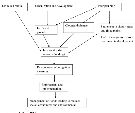
According to the conceptual framework developed, roof catchment and improvement of existing
policies and regulations is the key to zero-flooding drive within the Mavoko area. Rainwater
harvesting will ensure precautionary measure that will ensure urban floods are managed and
support in implementation of different rain harvesting methods.
Efforts from every quarter will be required towards reducing floods within the area with
26 Fig 2.2: Conceptual Framework.
Source: Author (2014).
Too much rainfall Urbanization and development. Poor planning
Increased paving
Development of mitigation measures.
Settlement in sloppy areas and flood plains.
Lack of integration of roof catchment in development. Clogged drainages
Increased surface run-off (flooding)
Enforcement and implementation.
27 CHAPTER THREE.
AREA OF STUDY.
3.1 Introduction.
Mavoko sub-county the former Municipal Council of Mavoko is one of the oldest Councils in
the country with its evolution dating back to 1940, when it began as Local Native Council (LNC)
then became an African District Council (ADC). The Town came into existence through trading
with the main business activity being centred at the old town area next to the railway station. It
became an Urban Council, curved from the County Council of Masaku now Machakos County in
1974 and got upgraded to a Town Council in 1987 and to a Municipal Council status in 1993.
The Council being a service provider operates under the Local Government Act. The Council has
core functions of planning all development activities within its area of jurisdiction (ESIA study,
2010).
3.2. The physical set up.
3.2.1. Location and extent.
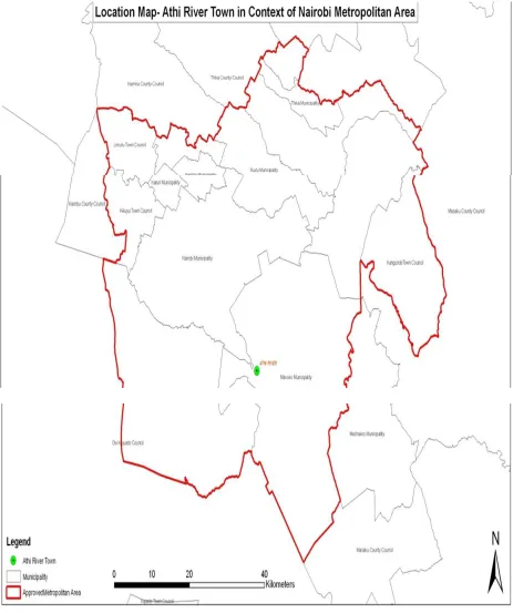
Mavoko sub-county covers an area of 693 km sq stretching from KAPA/ Airport area where it
borders with Nairobi County, and covers Katani, Ruai, Kangundo Road through
Muthwani-Lukenya, Makutano(Kyumbi) to the east where it boarders Machakos Town. It covers Kapiti
Plains to the south west towards Kitengela area where it borders with Kajiado County then to
Embakasi in Nairobi County and it is located 1° 27′ 0″ S, 36° 59′ 0″ E.The research is intended
to cover the following areas; syokimau, Athi river, and mlolongo which are setillite towns of
Mavoko Sub-County. This towns according to the (2009) census carries almost 50% the
28
commercial, residential, and industrial development which has resulted to increased paved
29
Figure 3.1: Location map of Mavoko Sub-County in the context of Nairobi Metropolitan
30 3.2.2. Topography and drainage.
The Mavoko area has gentle slope topography which is generally flat in most part of the area
with a gradient of not more than 3%, lying at an altitude of 1500m to the east and 1530m towards
the west. most of the land area has been under the influence of man due to the development
activities mainly from the construction industry to soil deposition from construction sites which
has shaped most of the land area giving it a new look. This has actually resulted to approximately
more than 70% of the entire area’s earth surface is covered by civil and structural works.
Mavoko sub-county in Machakos County is largely in a semi-arid zone and the amount and
frequency of precipitation is quite erratic. The sub-county lies within the drainage basin of River
Athi. The general drainage pattern is from West to East. Athi River and its tributaries, most of
which dry up during the dry spell, Ground water potential in the sub-county ranges from
moderate to low. This is because of the massive nature of the parent basement rock. Because the
rock bearing formation carries a high quantity of soluble minerals, most of the ground water is
saline.
Water Supply the Mavoko Water and Sewage Company is responsible for supplying potable
water to the residents and businesses in Mavoko county and its environs. Currently the
sub-county receives water from a variety of sources with the bulk of the water coming from Nairobi
through a piped system. The other source of water is the Nol-Turesh water pipeline that emanates
from Mt. Kilimanjaro, boreholes that the Mavoko Water and Sewage Company contracts out to
various service providers. The water from boreholes generally has a high saline content which
31
exploring ways of rehabilitating a disused dam to generate a considerable amount of water for
the growing population in Mavoko sub-county and its surroundings.
Due to increase in population and economic activities, the water resource is continuously
becoming scarce. Consequently, conservation measures such as afforestation, construction of
sub-surface dams along the river valleys and construction of dams and pans to capture surface
water run-off can improve both surface and ground water availability. The community in some
areas however are trying to remedy this situation. An example is the community of Muusini
village which has constructed a total of 16 sub-surface dams/weirs across rivers Makilu and
Syuuni in Kalama division to act as water retention points.
Unplanned development of small scale enterprises (Jua Kali) without proper infrastructural
services has led to an increase in pollution of the water courses especially in the major towns.
Examples are the garages within Machakos town that are located within Kariobangi and Grogan
areas. These cause pollution of the Iiyini River through oil spills, inappropriate handling of the
oil residues, exhaust fumes, etc. The problem is especially aggravated during the rainy season
when the pollutants find their way into the river courses. (Machakos DEAP, 2006).
3.2.3. Geology and soils.
According to Geaverts, 1964, The lithology of the Mavoko area comprises various geological
sequences. The volcanic rocks in the area are represented by Upper Athi Series consisting of
sediments and Lake Beds, Athi Tuffs and Kapiti phonolite. The thickness of these volcanic
varies decreasing towards the south and southeast as they reach the limit of the lava flows.
Immediately below the volcanics are the undifferentiated crystalline rocks of the Mozambique
32
shallow seated and have been encountered by several of the numerous Boreholes drilled in the
vicinity of the area.
The Upper Athi Series forms part of the extensive Athi tuffs and lake beds occurring as a result
of consolidation of fragmental volcanic material which was deposited shallowly into water after
eruption and a series of sediments and tuffs lying between the Nairobi and the Kapiti phonolite.
They are also taken to include beds of the Kerichwa Valley series where the phonolite and
trachytes are absent. Everywhere with Kapiti Phonolite, the unit underlies associated volcanic
rocks and is oldest lava of the succession. This has been confirmed by several borehole sections,
which have revealed that the sub-volcanic floor over which the Kapiti Phonolite was extruded
was irregular and cut in Precambrian rocks. The lava was laid down on an eroded surface
covered in places by Tertiary conglomerates and grits (Fairburn, 1963), formed part of the first
Miocene flood eruptions. The rock is distinctive in hand specimens by its large white crystals of
feldspar and waxy-looking nephelines which are set in a fine grained dark green to black or dark
bluish-grey groundmass. The basement system of this area comprises crystalline rocks of
Precambrian age which are exposed in the south west of Kitengela in Kajiado County where the
volcanic cover has been removed by erosion. They are predominantly biotite gneises, frequently
migmatitic and rich in hornblende.
Vertisols: these are referred to as black cotton soils. They are characterized by cracking clays
with low water permeability and high water holding capacity. The soils although moderately
fertile, have poor drainage and become water logged when wet. The soils are found on plateaus
and low lying flat lands in the district. They are used in production of cotton, chickpea and
33 3.2.4. Climate and physical features.
Mavoko sub-county climate is semi arid with a hilly terrain with altitude of 1000 to 1600 meters
above sea level. It has two rainy seasons, the long and the short rain seasons. The sub-county has
a bimodal rainfall pattern with the long rains seasons starting at the end of March and continues
up to May, while the short rains season starts at the end of October and lasts till December. The
annual average rainfall ranges between 500mm to 1300mm. Mean monthly temperatures vary
between 180C and 250C. The coldest month is July while October and March are the hottest.
This area is covered with dry bushes and savanna grassland with scattered trees. The most
widespread vegetation type in this area is the semi-arid deciduous thicket and bushland such as
acacia. (Aron M, May, 30th.2013 retrieved 31st, 11, 2013).
3.3Ecological set up.
3.3.1. Vegetation and soils
The Athi-Kapiti ecosystem are the Grass plain maim habitat is dominated by Cynodon,
Themeda, Cypress, and Digitaria species; Dry forest, Olea Africana, Croton dichogamus,
Brachylaena hutchinsii, and Calodendrum; Riverine forest/valley forest, Acacia xanthophloea,
Euphorbia candelabrum, Apodytes dimidiate, Canthium schimperiana, Elaeodendron buchananii,
Ficus eriocarpa, Aspilia mossambicensis, Rhus natalensis, and Newtonia species.The vegetation
34 3.3.2. Wildlife.
The Types of Wildlife include;Zebra, Wildebeest, Cokes’heartbeest, Elands, Giraffes,
Thomson’s Gazelle, Grant Gazelle, Buffalo, Waterbuck, Oribi, Lion, Cheetah, Leopards,
Warthogs, Ostriches, Impalas, DikDik, Hyena, Reedbucks.
Wildlife is mostly found in the private ranches such as Maanzoni ranch though they also occur in
other areas. The wildlife migrates during dry seasons in search of pasture between Kajiado and
Machakos/Makueni counties and their numbers depend on the seasons over the year.
3.4. The economical set up.
3.4.1. Agriculture.
The land with high potential of agricultural production in Mavoko sub-county is in areas such as
Athi-river, utawala and Muthwani. There are two types of agricultural systems in the sub-county
namely: Rainfed Agricultural and Irrigation Agricultural System. Major crops grown in this area
which are rainfed are maize, beans, millet, cowpeas, peas, green grams, chick peas, dolichos,
sweet potatoes, arrow roots, Irish potatoes and cassava. Those depend on irrigation are mostly
fruits and vegetables. They include; bananas, pawpaw, mangoes, passion fruits, avocados,
loquats, apples, tomatoes, cabbage, guavas, onions, French beans, carrots, kales, okra, karalla,
duohi, tundoori, turia, valore, thin and big chilies (Machakos District Planning Unit, 2006).
Large scale farming in Mavoko sub-county include flower farms which takes place mostly in
Athi-river and Lukenya areas. Some of large farms are Waridi, Primarosa, Banbros and Sun-rose
among others. Subsistence agriculture is also practiced, with maize and drought-resistant crops
such as sorghum and millet being grown due to the areas semi-arid state. These crops are highly
35
destroy farm products resulting to limited yields, hunger to the affected community which
accelerates community susceptibility to disasters.
Livestock production is practiced in both high and low potential areas of the sub-county.
Dairy-Farming (mostly zero grazing) is more predominant in the high potential areas of athi-river,
Utawala, Ruai, and kyumvi. All ranches are in the low potential areas of Lukenya and Kapiti and
most of them keep beef animals. Others include; Goat, Sheep Poultry farming, Pigs, Rabbit,
Donkey, and Bee Keeping. Annual occurrence of floods affects the growth of pasture and
increases animal water borne related diseases leading to massive deaths of livestock.
3.4.2. Trade and commerce and industry.
The sub-county is relatively industrialized with cement industries, meat processing, quarrying,
manufacturing industry, real estate, hotel industry and flower farms. The Cement industries are:
Bamburi cement, Portland cement, Mombasa cement, Savanna cement, National and Athi river
mining cement. Manufacturing industries included; Devki steel millers, Saj ceramics. Real
estates are; Sunset blouvered, Jam city, 360. Green Park, Lukenya Hills, Moke Gardens, Delta
plains, Sheshe, Parkview among others. The Hotels are; Millennium hotel, Green Gardens,
Connection Hotel, Interchange motel, and Intercontinental Hotel. Mavoko is also the home to
farmers Kenya meat commission (KMC).
However, the sub-county also plays host to the open air market concept with major market days
where large amounts of produce are traded. Fruits, vegetables and other food stuffs like maize
36 3.4.3. Transport and communication.
Approximately 510 Ha of land comprising 5% of total land area was provided for transportation.
This encompasses land set aside for roads, railway, petrol services stations, lorry parks and car
parks. The main routes include; Nairobi – Mombasa highway (A109) which carries a significant
amount of daily traffic, Nairobi-Namanga Road (A104). (ESIA Study April, 2011), there are also
unclassified roads minor roads linking minor centers within the area. Mavoko sub-county also
has a railway station built in 1920 along the Mombasa Nairobi line. These minor roads linked to
the satellite towns under the study are constructed using murram which is oftenly washed away
by surface run-off when it rains. This makes it impossible to access the remote areas and rescue
flood victims.
3.5. Social set up
3.5.1. Population.
The sub-county satellite towns are growing residential area due to its proximity to the Nairobi
city hence acting as a dormitory to workers working in the city. The population growth rate for
the sub-county is 1.7% and for Athi River Township is 5.2%.With the most populated areas of
the sub-county being towns of Mlolongo, Athi-river and Kyumvi (ESIA study, 2010).
According to the population census of (1999), Mavoko had a population of 48,260 where by
22,000 people of this population lived in urban areas of the sub-county. The Physical
Development Research Project which was done in 2004 the total population was 61,809 people,
2008 estimates the population within the jurisdiction of the Mavoko sub-county was