Article
1
Radar Data Analyses for a Single Rainfall Event and
2
their Application for Flow Simulation in an Urban
3
Catchment Using the SWMM model
4
Mariusz Barszcz
5
Department of Hydraulic Engineering, Warsaw University of Life Sciences – SGGW, 02-776 Warsaw, Poland;
6
[email protected]; Tel.: +48-22-593-5284
7
8
Abstract: In this study, regression analyses were used to find a relationship between the rain gauge
9
rainfall rate R and radar reflectivity Z for the urban catchment of the Służewiecki Stream in
10
Warsaw, Poland. Rainfall totals for 18 events which were measured at two rainfall stations were
11
used for these analyses. Various methods for determining calculational values of radar reflectivity
12
in reference to specific rainfall cells with 1-km resolution within an event duration were applied.
13
The influence of each of these methods on the Z-R relationship was analyzed. The correction
14
coefficient for data from the SRI (Surface Rainfall Intensity) product was established, in which the
15
values of rainfall rate are calculated based on parameters a and b determined by Marshall and
16
Palmer. Relatively good agreement between measured and estimated rainfall totals for the
17
analyzed events was obtained using the Z-R relationships as well as the correction coefficient
18
determined in this study. Rainfall depths estimated from radar data for two selected events were
19
used to simulate flow hydrographs in the catchment using the SWMM (Storm Water Management
20
Model) hydrodynamic model. Different scenarios were applied to investigate the stream response
21
to changes in rainfall depths, in which the data both for 2 existing as well as 64 virtual rain gauges
22
assigned to appropriate rainfall cells in the catchment were included.
23
Keywords: urban catchment; radar reflectivity; rainfall rate; Z-R relationship; SWMM model; flow
24
simulation
25
26
1. Introduction
27
Monitoring and prediction of rainfall events and their consequences are of primary importance
28
to hydrology [1-3]. In many small urban catchments, there is a problem with obtaining rainfall data
29
necessary for hydrological applications. In the case of taking measurements using rain gauges, there
30
is often a problem resulting from their low density in the catchment or as a result of them
31
temporarily turning off due to failure. Applying data registered at rainfall stations as input data for
32
hydrological models requires, in the majority of cases, the spatial interpolation of rainfall data [4].
33
One of the means of measuring rainfall depth is to make use of weather radar technology.
34
Information obtained on the basis of weather data provides the most detailed information in regards
35
to the spatial and temporal distribution of rainfalls [5]. These features potentially improve the
36
simulation and forecasting of stream flows [6-10].
37
The demand for a better understanding of hydrological processes at different spatial scales
38
requires the application of more integrated and advanced techniques of rainfall detection and
39
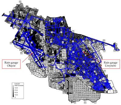
estimation rather than applying only data from conventional networks of ground based rain gauges
40
[11]. Due to their ability to capture the spatial characteristics of rainfall fields well and their
41
evolution in time, radar rainfall estimates are playing an increasingly important role in urban
42
hydrological applications [12-16]. The use of more detailed and distributed models increased the
43
demand for good quality, high resolution inputs, which promotes the use of radar rainfall data in
44
urban hydrology [17].
45
The use of radar data in hydrological applications requires expanding on knowledge on the
46
topic of the uncertainty of radar data [18]. The main flaw of radar observations is the imprecision of
47
the obtained rainfall data [19-21], which results from the fact that it is an indirect measurement.
48
Weather radar do not measure rainfall directly but rather the back scattered energy from
49
precipitation particles from elevated volumes, and an algorithm should be developed and calibrated
50
against the rain gauge network [22].
51
This research uses regression analyses to compare the relationship between the rain gauge
52
rainfall rate R and radar reflectivity Z to find a proper Z-R relationship for the investigated
53
catchment area of the Służewiecki Stream in Warsaw, Poland. The analysis was carried out on the
54
basis of rainfall data which were registered at 2 rainfall stations in the analyzed catchment for a few
55
single rainfall events as well as obtained as a result of processing radar data. On the basis of the
56
established Z-R relationship, the rainfall depth for the analysed events was calculated and compared
57
with respective data measured using rain gauges. Such a comparison was also carried out on the
58
basis of data established directly from the SRI (Surface Rainfall Intensity) as well as data calculated
59
upon applying an established value of the correction coefficient.
60
Rainfall depth for two selected events which were obtained on the basis of radar data using
61
various methods and registered using rain gauges were applied to simulate flows in the analysed
62
catchment with the use of the hydrodynamic SWMM model. The values of peak flow and outflow
63
volume, which were calculated for the analysed rainfall-runoff events were compared with
64
respective parameters of the hydrograph measured in two cross-sections of the Służewiecki Stream
65
(located at two subcatchment outlet profiles).
66
As described in the paper [23], it appears that the uncertainty on the simulated peak flow is
67
significant, reaching for some conduits in the small urban catchment of Cranbrook (London) 25%
68
and 40% respectively for frontal and convective events. For some events, radar data input resulted in
69
better flow simulations whereas for other events, the rain gauge data input resulted in better flow
70
simulations [24].
71
2. Materials and Methods
72
2.1. Description of the studied area
73
In quantitative rainfall analysis, data registered at the Okęcie and Ursynów rainfall stations,
74
located in the area of the analysed Służewiecki Stream catchment in Warsaw, were applied. In the
75
quantitative analysis regarding the flows, hydrographs measured in the Kłobucka and Rosoła
76
cross-sections were used (see Figure 1).
77
Figure 1. Drainage and measuring system of the Służewiecki Stream catchment in Warsaw;
80
cross-sections (outlet-profiles) and rainfall stations: 1 - Rosoła, 2 - Kłobucka, 3 – Okęcie, 4 – Ursynów.
81
The area of the subcatchment for the Kłobucka cross-section is 16.5 km2, with a share of effective
82
impermeable surfaces (hydraulically connected with storm sewers) equal to approx. 23%. Warsaw
83
Chopin Airport, from which rainwaters are directed to the Służewiecki Stream by a storm water
84
drainage system, occupies the vast majority of the area of this catchment. The Służewiecki Stream, in
85
the segment from its source to the Kłobucka cross-section (6.5 km in length), is closed along almost
86
the entire length. In the area of the airport, retention tanks with a total capacity of 42,490 m3, which
87
have a large influence on the transformation of flows in the watercourse, are found.
88
The area of the subcatchment to the Rosoła cross-section is 43.0 km2. The share of effective
89
impermeable surfaces is approx. 26.0%. A part of this catchment, which is drained by the Grabowski
90
Drainage Ditch, is mainly agricultural and forest-type land. The remaining part of the catchment,
91
drained by a drainage system, is used for industrial, commercial, transportation and multi-family
92
residential development purposes. It is characterized by a large share of impermeable surfaces. The
93
average slope of the Służewiecki Stream is approx. 1.5‰, and slopes of the areas in the catchment
94
are usually less than 1%.
95
Rainfall depths at the Okęcie and Ursynów rainfall stations were registered using electronic
96
tipping bucket rain gauges. The first of them is controlled by the Institute of Meteorology and Water
97
Management – National Research Institute (Polish: IMGW-PIB), while the second – by the Division
98
of River Engineering in Warsaw University of Life Sciences – SGGW. Water levels on the basis of
99
which flows were calculated were registered using a hydrostatic sensor of the “Diver” type.
100
Służewiecki Stream
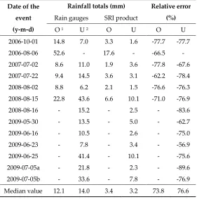
1
3
4
watercourses
drainage pipes / storm sewer closed tanks
open reservoirs outlets / flow gauges rainfall stations / rain gauges
Grabowski Ditch Służewiecki Stream
Vistula River
2.2. The SWMM model for the studied area
101
To stimulate flow in the analysed catchment in response to single rainfall events, version 5.0.022
102
of the SWMM (Storm Water Management Model) was applied. SWMM is a fully dynamic
103
rainfall-runoff model, as well as being a fully distributed deterministic model. The model is
104
characterized by a large number of parameters, which are mainly physically measurable
105
characteristics of the catchment and hydrometeorological conditions. An extensive description of the
106
model can be found in the manual [25]. Numerous examples of its application for simulating flow in
107
urbanized catchments can be found in the scientific publications of various authors [26-30].
108
The adaptation of the SWMM model for the analysed catchment relied on creating objects in the
109
model which represent the physical elements of the actual hydrological and hydraulic system of the
110
catchment, and next - on determining the values of their parameters and calibration. In order to
111
assess and identify the parameters of the objects in the model, the authors used characteristics of real
112
objects measured in field and identified based on the available studies, as well as values of
113
parameters recommended in the tables of the manual [25].
114
Figure 2. The storm drainage system, subcatchments and rain gauges (two existing and 64 virtual
115
objects) in the SWMM model for the studied area.
116
The following objects were accounted for in the SWMM model, which had been adapted for the
117
analysed catchment (see Figure 2):
118
the existing rain gauges at the Okęcie and Ursynów rainfall station (assigned to two rainfall
119
cells with an area of 1 km2, which correspond to appropriate pixels on the map in the SRI radar
120
product);
121
Rain gauge Ursynów Rain gauge
virtual rain gauges, in which the rainfall depths were estimated on the basis of radar data
122
(assigned to 64 rainfall cells covering the area of the catchment);
123
subcatchments, which had been distinguished in the catchment in order to account for the
124
spatial diversity of land use in the catchment and the share of impermeable surfaces connected
125
with this (4,565 objects);
126
open channels, watercourses and drainage pipes (2,271 objects);
127
road culverts and bridges;
128
retention tanks, pumps and valves used to regulate flow, working together with the tanks.
129
2.3. Methods of radar data analysis
130
Upon processing values of radar reflectivity registered by the radar, we obtain different
131
meteorological and hydrological products. One of these products is SRI (Surface Rainfall Intensity),
132
which presents a picture of rainfall intensity R in a layer characterized by a constant height above the
133
surface of the ground [31]. The Institute of Meteorology and Water Management - National Research
134
Institute, which carries out measurements in Poland using radars and makes SRI products available,
135
when calculating precipitation (rainfall) rate R on the basis of registered radar reflectivity Z, makes
136
use of Equation (1) – presented in inverse order, i.e. expressing Z by R, based on a and b coefficients
137
determined by Marshall and Palmer [32], which equal 200 and 1.60 respectively [31].
138
= , (1)
where Z is radar reflectivity (mm6·m-3), R is the rainfall rate (mm·h-1), a and b are constants.
139
140
The work used the SRI product obtained as a result of processing reflectivity data derived from
141
the C-Band Doppler radar located approx. 30 km north of the Okęcie and Ursynów rainfall stations
142
(in the town of Legionowo). The applied SRI product presents values of rainfall intensity in the area
143
covered by the radar in a layer located at a height of 1 km above the surface of the ground, with 1 km
144
resolution and 10-minute intervals.
145
A specialized programme – RAPOK (developed at the IMGM-PIB) was used to analyse the
146
values of rainfall intensity on the basis of the SRI product, making it possible to generate radar data
147
in the form of a file compatible with the Microsoft Excel format for the area covering the analysed
148
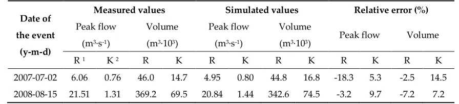
catchment (fields in a shape close to a square, containing 156 pixels with 1 km resolution). From data
149
for 156 pixels, values of rainfall intensity for 66 pixels located in the Służewiecki Stream catchment
150
were selected and used for analyses in accordance with the scope of the present work. Figure 3
151
shows a sample SRI product map in the RAPOK programme, corresponding to one of the analysed
152
rainfall events which occurred on 02.07.2007 at 21:40. On the basis of rainfall intensity values R
153
derived from the SRI product for 66 pixels, the corresponding values of radar reflectivity Z were
154
calculated for each of the analysed events (at individual time intervals of rainfall duration). The
155
calculations were carried out on the basis of relation (1) based on a and b coefficients amounting to
156
200 and 1.6, respectively, determined by Marshall and Palmer.
157
Figure 3. SRI product (map of rainfall intensity) and area covering the analyzed catchment (156
159
pixels).
160
Next, regression analyses were applied in an effort to establish the values of parameters a and b
161
in Z-R relationship (Equation (1)) for the investigated catchment area of the Służewiecki Stream in
162
Warsaw. The analysis was carried out on the basis of values of rainfall intensity measured at the
163
Okęcie and Ursynów rainfall stations for 18 events and corresponding values of radar reflectivity. A
164
regression line in a logarithmized variable logZ and logR set was obtained. In this analysis, in order
165
to establish the calculational values of radar reflectivity for each of the events in relation to the points
166
in the catchment corresponding to the locations of the Okęcie and Ursynów rainfall stations, five
167
different methods were applied. They differed in terms of the number of data (ranging from 1 to 4
168
values of radar reflectivity, corresponding to nodes in pixels in which rainfall stations are located) on
169
the basis of which the calculational values of radar reflectivity were established at individual time
170
intervals of rainfall duration. To establish them, the following were assumed: 1) one value of radar
171
reflectivity obtained in two pixels for the node located nearest with regards to the point where the
172
given rainfall station is located; 2) the lowest value of reflectivity for nodes in a given pixel; 3) the
173
highest value of reflectivity; 4) the average value of reflectivity calculated on the basis of data for
174
four nodes; 5) the value of the median for data from four nodes in corresponding pixels. The
175
influence of each of these methods on the values of parameters a and b in Equation (1) was analysed,
176
and thus, the compatibility of the estimated rainfall totals for the analysed events with the
177
corresponding data measured at rainfall stations.
178
Rainfall depths measured using rain gauges as well as obtained on the basis of the SRI product
179
for 18 rainfall events were used to establish the ratio of these data in individual time intervals of
180
rainfall duration (10 minutes), and next, their values of the average (correction coefficient) for all
181
data. The established value of the correction coefficient amounting to 3.6 was used to calculate
182
rainfall depths for the analysed events on the basis of data from the SRI product, which were
183
compared with data measured using rain gauges.
184
3. Results and discussion
186
3.1. Radar reflectivity-rainfall rate relationships
187
The Z-R relationship (Equation (1)), with coefficients derived by Marshall and Palmer, is
188
commonly used for radar rainfall estimation. In a further part of the work, it was indicated that
189
rainfall totals calculated for the analyzed events using this relationship were much lower than those
190
measured using rain gauges. As a result of this, an attempt was made to establish Z-R relationships
191
which offer better rainfall rate estimation in the investigated catchment area as compared to that of
192
Marshall-Palmer. Eighteen rainfall events, which were measured simultaneously at the Okęcie and
193
Ursynów rainfall stations (6 and 12 events respectively) as well as using a weather radar, were
194
accepted for this analysis. The events were characterized by different rainfall totals, ranging from 8.6
195
to 52.6, and 6.2 to 43.6 (see Table 1), registered respectively at the Okęcie and Ursynów rainfall
196
stations. Five various methods of establishing calculational values of radar reflectivity for each of the
197
events in reference to the points in the catchment corresponding to the location of the Okęcie and
198
Ursynów rainfall stations which had been described in the previous chapter were used. Five Z-R
199
relationships (differing in terms of the values of a and b coefficients) were obtained in reference to
200
each of the rainfall stations. On the basis of these relationships and calculational values of radar
201
reflectivity, the rainfall depths (totals) for the analysed events were estimated and compared with
202
corresponding data measured at the rainfall stations. The application of Equations (2) and (3),
203
established using only 12 events measured at the Ursynów rainfall station was found to result in the
204
highest compatibility of these data in reference to all analysed events. The relationships were
205
characterized by correlation coefficients amounting to 0.84 and 0.83 respectively. These relationships
206
were assumed for calculating rainfall depth on the basis of radar data corresponding to the Okęcie
207
and Ursynów rainfall stations.
208
= 64 . , (2)
= 66 . ,
(3)
Symbols designated as in Equation (1).
209
210
Equations (2) and (3) were obtained using two methods in which the calculational values of
211
radar reflectivity were established respectively on the basis of one value of reflectivity (determined
212
for the node located nearest in terms of the point where the Ursynów rainfall station is located) as
213
well as the value of the median for data from four nodes of the pixel in which the Ursynów rainfall
214
station is located. Z-R relationships, which were established applying three remaining methods (in
215
reference to events measured at the Ursynów rainfall station), were characterized by correlation
216
coefficients in the range of 0.80 to 0.85. Values of a and b parameters in these relationships, which
217
were established on the basis of the lowest value of reflectivity for nodes at a given pixel, the highest
218
value of reflectivity and the average value of radar data for four nodes in the pixel, were a = 42 and
219
b = 1.17, a = 86 and b = 1.32, a = 65 and b = 1.25 respectively.
220
In literature, there is high variability of the Z-R relationship (Equation (1)) coefficients. The
221
value of coefficients a and b, established in many analyses in different regions of the world, fall
222
within ranges from 16.6-730 and 1.16-2.87 respectively [31]. The values of parameter a can change
223
of 1 ≤ b ≥ 3 [33-35]. According to other data [36, 22], values of a and b fall within the respective ranges
225
of 31-500 and 1.1-1.9. The values of coefficients established in this study are within the ranges
226
obtained by other authors.
227
3.2. Comparison of radar estimates with rain gauge measurements
228
Rainfall totals for 18 events which were obtained directly from the SRI product (in which the
229
values of rainfall rate were calculated based on parameters a and b determined by Marshall and
230
Palmer) as well as were calculated applying correction coefficient for data from the SRI product
231
(equal to 3.6) and estimated on the basis of Z-R relationships (2) and (3) established in this work,
232
compared with corresponding data measured using rain gauges at the Okęcie and Ursynów rainfall
233
stations (see Table 1-2).
234
Compatibility assessment of the rainfall totals for the analysed events obtained on the basis of
235
radar data and measured using rain gauges was carried out with the use of values of relative error
236
(Equation (4)). A value of 25% was assumed as limiting for acceptance. The results were further
237
assessed using the Nash-Sutcliffe Efficiency coefficient - NSE [37, 28-29]. Model performance can be
238
evaluated as satisfactory if NSE > 0.50, good if NSE > 0.65 and very good if NSE > 0.75 (with NSE = 1
239
being the optimal value) [38].
240
= − ∙ 100%, (4)
where RE is the relative error, x is the calculated value, x0 is the measured value.
241
242
Table 1. Rainfall totals using rain gauges and SRI product data.
243
Date of the
event
(y-m-d)
Rainfall totals (mm) Relative error
(%) Rain gauges SRI product
O 1 U 2 O U O U
2006-10-01 14.8 7.0 3.3 1.6 -77.7 -77.7
2006-08-06 52.6 - 17.6 - -66.5 -
2007-07-02 8.6 11.0 1.9 3.6 -77.8 -67.6
2007-07-22 9.4 14.5 3.6 3.1 -62.2 -78.4
2008-08-02 8.8 6.2 2.1 1.5 -76.6 -76.3
2008-08-15 22.8 43.6 6.6 10.1 -71.0 -76.9
2008-08-16 - 15.2 - 2.5 - -83.6
2009-05-30 - 13.5 - 5.0 - -62.7
2009-06-16 - 10.5 - 2.6 - -75.0
2009-06-23 - 7.8 - 3.4 - -56.9
2009-06-25 - 41.4 - 10.1 - -75.6
2009-07-05a - 21.8 - 2.3 - -89.6
2009-07-05b - 33.6 - 7.8 - -76.9
Median value 12.1 14.0 3.4 3.2 73.8 76.6
1, 2 Rain gauges: O – Okęcie, U - Ursynów
244
Rainfall totals for the analysed events which were determined directly from the SRI radar
245
lower than corresponding data measured using rain gauges (see Table 1). In regards to 18 events at
247
the Okęcie and Ursynów rainfall stations, the values of the median of relative error were 73.8 and
248
76.6% respectively (calculated for absolute values of relative error). The estimation accuracies of
249
rainfall totals using SRI radar product, as assessed by the NSE values, were -0.19 and -0.89,
250
respectively for data at the Okęcie and Ursynów rainfall stations. These values indicate an
251
unacceptable level of performance.
252
The results of this analysis indicate that a calibration step that compares radar predicted rainfall
253
to “true rainfall” is still needed. Radar users are required to modify, on their own, the radar data by
254
means of rain gauges located within the target catchment in order to remove the bias [39-41].
255
Relatively few tests of gauge-based adjustment methods have been conducted on small urban scales
256
and all of them have concluded that, on these scales, more dynamic and localized adjustments are
257
required [12, 42]. In studies carried out in Northern France for a long, heavy rainfall event that
258
resulted in flooding and heavy damage, strong underestimation of the estimated rainfall total based
259
on radar data was observed, despite considerable improvement in radar technology and algorithms
260
[43]. In an analysis carried out in Malaysia using hourly rainfall data, more than 80% of data
261
obtained from the radar were overestimated when compared to rain gauge observations [44]. As
262
described in the work [45], when comparing the C-band and X-band rainfall totals to those resulting
263
from tipping bucket rain gauges, one may note that the X-band radar tends to underestimate, while
264
C-band radar generally overestimates them.
265
266
Table 2.Rainfall totals using rain gauges and SRI product data.
267
Date of the
event
(y-m-d)
Rainfall totals (mm) Relative error (%)
Eq. (2) Eq. (3) SRI · 3.6 Eq. (2) Eq. (3) SRI · 3.6
O 1 U 2 O U O U O U O U O U
2006-10-01 15.8 5.0 16.5 4.4 11.9 4.2 6.7 -29.0 11.6 -36.7 -19.7 -40.6
2006-08-06 61.6 - 62.1 - 63.5 - 17.1 - 18.1 - 20.6 -
2007-07-02 5.6 12.6 6.3 11.7 6.9 12.8 -35.2 14.2 -27.3 6.2 -20.1 16.5
2007-07-22 20.1 14.9 19.6 15.5 12.8 11.3 114 3.0 109 6.8 36.1 -22.3
2008-08-02 7.0 4.2 7.4 5.7 7.4 5.3 -20.2 -32.9 -15.5 -7.7 -15.7 -14.7
2008-08-15 24.7 37.2 30.2 35.6 23.8 36.2 8.1 -14.6 32.5 -18.3 4.4 -17.0
2008-08-16 - 10.7 - 12.0 - 9.0 - -29.4 - -20.9 - -41.1
2009-05-30 - 20.7 - 21.0 - 18.2 - 53.0 - 55.3 - 34.5
2009-06-16 - 8.1 - 8.3 - 9.5 - -23.2 - -20.8 - -9.8
2009-06-23 - 10.5 - 10.8 - 12.1 - 34.0 - 38.5 - 54.9
2009-06-25 - 46.1 - 53.7 - 36.3 - 11.3 - 29.7 - -12.3
2009-07-05a - 10.1 - 12.5 - 8.2 - -53.7 - -42.6 - -62.6
2009-07-05b - 31.2 - 27.1 - 27.9 - -7.1 - -19.4 - -16.8
Median val. 18.0 11.6 18.1 12.3 12.3 11.7 18.7 26.1 22.7 20.8 19.9 19.7
1, 2 Rain gauges: O – Okęcie, U - Ursynów
268
Values of the median of relative error determined on the basis of the sum of rainfall measured
269
using rain gauges and calculated using Z-R relationship (Equation (2)) for the analysed events at the
270
estimation accuracies of rainfall totals using this equation, as assessed by the NSE values, were, in
272
both cases, 0.85. This value indicates a very good level of performance. The values of the median of
273
the relative error, established in the analysis using Z-R relationship (Equation (3)) for events at the
274
Okęcie and Ursynów rainfall stations, were 22.7 and 20.8% respectively. The NSE coefficients were
275
0.82 and 0.78. For this statistic, model performance can be evaluated as very good. The established
276
Equations (2) and (3), the application of which requires the identification of calculational values of
277
radar reflectivity on the basis of data for one and four nodes in a given pixel, offer better rainfall rate
278
estimation in the investigated area compared to Marshall-Palmer`s relationship. Using three other
279
Z-R relationships, which were established on the basis of the lowest value of reflectivity for data in
280
nodes in a given pixel, the greatest value of reflectivity and the average value for data in four nodes
281
of a pixel (described in greater detail in the previous chapters), the values of the median of relative
282
error for events at Okęcie and Ursynów rainfall stations of 27.6 and 27.9%, 28.0 and 26.6% and 23.8
283
and 23.4% were obtained. The values of the median of relative error established using the correction
284
coefficient for data from the SRI product (SRI · 3.6) were 19.9 and 19.7% respectively for the Okęcie
285
and Ursynów rainfall stations, The obtained values of NSE, i.e. 0.90 and 0.80, indicate a very good
286
level of performance. In this study, carried out using various methods, both underestimation and
287
overestimation of the estimated rainfall total based on radar data was observed. The highest
288
agreement between rainfall totals which were estimated for the analyzed events based on radar data
289
and using rain gauges were noted when the correction coefficient for data from the SRI product was
290
used and upon applying Z-R relationships (Equation (2) and (3)).
291
3.3. Simulation of flow using different rainfall data
292
Rainfall depths measured at rain gauges and estimated from weather radar data for two
293
selected events were applied to simulate hydrographs in two cross-sections of the Służewiecki
294
Stream using the SWMM model. The results of simulations of peak flows and outflow volumes,
295
obtained in the Kłobucka and Rosoła cross-sections (see Figure 1), have been compiled in Tables 3
296
and 4. Rainfall-runoff events occurring on 2 July 2007 and 15 August 2008 were used for these
297
analyses. The events are characterized by diverse values of parameters. The rainfall totals for these
298
events were 8.6 and 22.8 mm and 11.0 and 43.6 mm, which were measured respectively at the Okęcie
299
and Ursynów rainfall stations. Values of peak flow and outflow volume of direct hydrographs
300
measured in the Kłobucka and Rosoła cross-sections have been given in Table 3.
301
302
Table 3.Results using rainfall depths measured at rain gauges.
303
Date of
the event
(y-m-d)
Measured values Simulated values Relative error (%)
Peak flow
(m3·s-1)
Volume
(m3·103)
Peak flow
(m3·s-1)
Volume
(m3·103) Peak flow Volume
R 1 K 2 R K R K R K R K R K
2007-07-02 6.06 0.76 46.0 14.7 4.95 0.80 44.8 16.8 -18.3 5.3 -2.5 14.5
2008-08-15 21.51 1.31 369.2 69.5 20.84 1.44 342.6 74.5 -3.2 9.7 -7.2 7.2
1, 2Cross-sections (outlet-profiles): R – Rosoła, K – Kłobucka
304
Assessment of the agreement between measured (observed) and simulated values of
305
ASCE [46] for single events. A value of 25% was assumed as the cut-off level for model acceptance
307
[47].
308
The values of relative error (RE) which were calculated for the analyzed events in two
309
cross-sections of the Służewiecki Stream in response to rainfall depths measured at two rain gauges
310
(uniformly distributed over two adequate areas in the catchment), ranged from -18.3 to 9.2% and -5.5
311
to 14.5% (see Table 3) respectively in relation to peak flows and outflow volumes. The simulated
312
values of parameters of the hydrograph obtained from the SWMM model were lower than the
313
assumed level of model acceptance (25%).
314
Different scenarios were applied to investigate the stream response to changes in rainfall depths
315
estimated from radar data for the analyzed events. Six scenarios in which rainfall depths for two
316
single events (in individual time intervals of the rainfall duration) were established according to the
317
following methods:
318
Scenario 1: directly on the basis of data from the SRI radar product (values of the intensity of
319
rainfall in a given node of a pixel which had been calculated based on the a and b coefficients
320
determined by Marshall and Palmer) for 66 rain gauges, which correspond to the pixels on SRI
321
product maps (including for 64 virtual and 2 existing rain gauges at the Okęcie and Ursynów
322
rainfall stations, located in cells with a surface area of 1 km2 covering the area of the analysed
323
catchment);
324
Scenario 2: upon applying Z-R relationship (Equation 2) and calculational values of radar
325
reflectivity for 66 rain gauges (obtained for one specified node in 66 pixels, the location of which
326
in each pixel corresponded to that established in two pixels for nodes located closest in terms of
327
the points at which the Okęcie and Ursynów rainfall stations are located);
328
Scenario 3: on the basis of data from the SRI product for 66 rain gauges and correction
329
coefficient amounting to 3.6;
330
Scenario 4: upon applying Z-R relationship (Equation 3) and calculational values of radar
331
reflectivity for 66 rain gauges (values of the median established in 66 pixels on the basis of data
332
for four nodes in each pixel);
333
Scenario 5: upon applying Z-R relationship (Equation 2) and calculational values of radar
334
reflectivity (established in two pixels for the node located nearest to the points at which the
335
existing rainfall stations are located) for rain gauges in Okęcie and Urysnów rainfall stations
336
(the point rainfall depths established for these rain gauges were uniformly distributed over two
337
adequate areas in the catchment);
338
Scenario 6: on the basis of data from the SRI radar product for 2 rain gauges at existing rainfall
339
stations and a correction coefficient amounting to 3.6 (the rainfall inputs were assumed to be
340
uniformly distributed over two areas).
341
348
Table 4.Results using rainfall depths estimated from radar data.
349
Date of
the event
(y-m-d)
Simulated values Relative error (%)
Peak flow
(m3·s-1)
Volume
(m3·103) Peak flow Volume
R 1 K 2 R K R K R K
Scenario 1
2007-07-02 0.82 0.10 6.0 1.6 -86.5 -87.5 -87.0 -88.9
2008-08-15 2.48 0.78 47.4 16.9 -88.5 -40.2 -87.1 -75.7
Scenario 2
2007-07-02 5.83 0.82 52.4 14.5 -3.8 8.4 14.0 -0.9
2008-08-15 22.03 1.66 394.2 90.3 2.4 26.4 6.8 29.9
Scenario 3
2007-07-02 5.35 0.77 50.2 15.5 -11.7 1.7 9.1 5.7
2008-08-15 19.68 1.64 331.8 82.2 -8.5 25.3 -10.1 18.3
Scenario 4
2007-07-02 5.21 1.00 56.0 19.1 -14.1 31.7 21.8 30.4
2008-08-15 22.95 1.85 441.3 94.8 6.7 40.8 19.6 36.5
Scenario 5
2007-07-02 5.55 0.70 46.3 12.6 -8.5 -7.5 0.7 -14.3
2008-08-15 17.35 1.58 273.5 71.6 -19.4 20.8 -25.9 3.0
Scenario 6
2007-07-02 5.40 0.78 46.6 14.9 -10.9 3.4 1.3 1.6
2008-08-15 16.90 1.55 261.0 69.3 -21.4 18.2 -29.3 -0.2
1, 2Cross-sections (outlet-profiles): R – Rosoła, K – Kłobucka
350
Values of peak flow and outflow volume in the Rosoła and Kłobucka cross-sections obtained
351
using the SWMM model in simulations carried out on the basis of data from the SRI radar product
352
(Scenario 1), were much lower than respective values measured in these cross-sections. In response
353
to the above-mentioned hygrogram parameters, the values of relative error were from -88.5 to
354
-40.2%, and from -88.9 to -75.7% respectively (see Table 4). For a small urban catchment, large
355
differences are observed in the peak flows simulated by radar and rain gauges due to the inherent
356
uncertainties from both rainfall estimates [14], which is confirmed by the results of this analysis. As
357
described in the work [48], the quality of radar-derived precipitation data without gauge-adjustment
358
is insufficient for use in flood risk management. Adjusting radar data son that it more closely
359
resembles the observations of rain gauges will consequently improve the results obtained with
360
distributed simulation models [49]. The results of flow simulations for five above-mentioned
361
scenarios in which the Z-R relationships established in this work along with the correction
362
coefficient were applied are described in a further part of the work.
363
Upon applying rainfall depths estimated on the basis of Z-R relationship (Equation 2) and
364
calculational values of radar reflectivity (established on the basis of radar data for a single given
365
node in each pixel), peak and total flow values obtained from the SWMM model were, in most cases,
366
-3.8 to 26.4% and from -0.9 to 29.9%, respectively. For two out of eight cases, the errors were higher
368
than the value of 25%, which had been assumed as the limiting value for acceptance. Good
369
agreement between measured and simulated values of parameters was also obtained in reference to
370
Scenario 3 in which the values of rainfall were calculated on the basis of data from the SRI product
371
for 66 rain gauges accounting for the correction coefficient. The relative error was higher than 25% in
372
only one case. In the analysis for Scenario 4, carried out applying rainfall depths estimated on the
373
basis of the Z-R relationship (3) and calculational values of radar reflectivity (established on the basis
374
of radar data for four nodes in each pixel), a lower agreement between the measured and simulated
375
values of the parameters of the hydrograph were obtained than for Scenario 2 (in which the
376
calculational values of reflectivity were established only on the basis of data from one node in each
377
pixel). The values of relative error ranged from -14.1 to 40.8% and 19.6 to 36.5% respectively in
378
regards to peak flows and outflow volumes. In four cases, the errors were higher than 25%.
379
In the analysis carried out for Scenario 5, in which the Z-R (2) relationship and calculational
380
values of radar reflectivity established for pixels in which the Okęcie and Ursynów rainfall stations
381
were located (calculated point rainfalls were uniformly distributed over two adequate areas) were
382
applied to calculate rainfall depths, high agreement between simulated and measured peak flow and
383
outflow volumes was obtained. The values of relative error were found to be from -19.4 to 20.8% and
384
from -25.9 to 3.0% respectively. Only in one case was the relative error slightly higher than 25%. In a
385
respective analysis carried out for Scenario 2, in which the calculational values of radar reflectivity
386
were determined for 66 pixels (applied to calculate the amount of rainfall for 66 rain gauges), similar
387
results of the simulation were obtained – the relative errors were higher than the level of acceptance
388
in two cases. Good agreement between the analysed parameters of the hydrograph was also
389
obtained in regards to Scenario 6, for which the rainfall depths were calculated on the basis of data
390
from the SRI product for 2 rain gauges and the correction coefficient. Only in one case was the
391
relative error higher than the value marking the level of acceptance. The obtained relative errors
392
(compiled in Table 4) indicate that the results of this analysis are comparable to those obtained for
393
corresponding Scenario 3, in which radar data for a much higher number of rain gauges in the
394
analysed catchment were used to carry out the simulation.
395
5. Conclusions
396
Different methods have been applied to estimate rainfall depths (totals) from radar data for 18
397
analysed single events. Calculated rainfall totals were compared with corresponding data measured
398
using rain gauges at two rainfall stations located in the analysed urban catchment. The
399
hydrodynamic SWMM model was used to simulate peak flow and outflow volume of hydrograph in
400
two cross-sections of the Służewiecki Stream in response to radar rainfall depths estimated for two
401
selected events using six methods.
402
The conducted analyses enable the following conclusions to be drawn:
403
1. Rainfall totals for the analysed events obtained directly from the SRI radar product (in which
404
the values of rainfall rate are calculated based on parameters a and b determined by Marshall
405
and Palmer) were much lower than the rainfall totals measured for these events at rainfall
406
stations. The values of the relative error ranged from -89.6 to -56.9%. The results of this analysis
407
indicate that a calibration step that compares radar estimated rainfall and rain gauge rainfall is
408
necessary. Respective values of relative error, ranging from -88.9 to -40.2%, were calculated for
409
parameters of the hydrograph simulated in response to rainfall depths obtained from the SRI
410
2. Based on rainfall depths measured at rainfall stations and obtained from the SRI radar product
412
for the analysed events (in individual time intervals of rainfall duration), the average value of
413
the ratio between these data amounting to 3.6 was determined. Rainfall totals which had been
414
calculated for individual events applying this correction coefficient and data from the SRI
415
product were characterized by an absolute value of the relative error median of 20%. The
416
obtained values of the NSE coefficient indicate a very good level of performance.
417
3. The Z-R relationships (2) and (3) determined in this study, the application of which requires the
418
identification of calculational values of radar reflectivity on the basis of data in one and four
419
nodes of a given radar map pixel, offer better rainfall rate estimation in the investigated area as
420
compared to Marshall-Palmer`s relationship (the values of coefficients a and b determined by
421
Marshall and Palmer differ significantly from those established in this work). The values of the
422
median of relative error, determined in the analysis using these relationships for events in two
423
rainfall stations, were between 11.6 and 18.1% respectively. The calculated rainfall totals were
424
both underestimated and overestimated.
425
4. Relative errors, which were obtained in a similar analysis using three other Z-R relationships
426
(established on the basis of the lowest and highest values of radar reflectivity as well as the
427
average value for data in four nodes of a given pixel), were significantly higher than those
428
calculated in the analysis applying Z-R relationship (Equation (2) and (3)). The absolute values
429
of the median of the relative error calculated on the basis of rainfall totals for events analysed at
430
individual rainfall stations ranged from 23.4 to 28.0%. As the values of relative error indicate,
431
the method applied to determine the calculational values of radar reflectivity was important.
432
5. In simulations carried out using the SWMM model in reaction to rainfall depths which had
433
been calculated for the analysed events using the correction coefficient for data from the SRI
434
product and estimated on the basis of the determined Z-R (Equation (2)) relationship, relatively
435
good agreement was achieved between the measured and simulated peak flow and outflow
436
volume values. The values of the relative error were, in most cases, lower than the assumed
437
cut-off level of model acceptance (25%). In this analysis, about 56% of peak flow and outflow
438
volume values obtained from simulations were overpredicted when compared to flow gauge
439
observations. For some events, radar data input resulted in better flow simulations than using
440
rain gauge data input.
441
6. The estimation errors of hydrograph parameters in some cases were not in agreement with
442
values of errors which had been calculated for respective rainfall totals, e.g. when rainfall total
443
error was relatively large and negative, the respective peak flow error was small and positive.
444
7. Using rainfall depths estimated from radar data for only 2 existing rain gauges (cells with 1 km
445
resolution) as well as 66 (including 64 virtual) rain gauges in the catchment, a similar range of
446
relative error values for simulated peak flows and outflow volumes was found, but different
447
values of errors in individual corresponding cases were obtained.
448
Acknowledgments: Information regarding radar data: The source of data is the Institute of Meteorology and
449
Water Management - National Research Institute. Data from the Institute of Meteorology and Water
450
Management - National Research Institute were processed.
451
Conflicts of Interest: The authors declare no conflict of interest.
452
References
453
1. He, X.; Sonnenborg, T.O.; Refsgaard, J.C.; Vejen, F.; Jensen, K.H. Evaluation of the value of radar QPE data
454
and rain gauge data for hydrological modeling. Water Resour. Res. 2013, 49, 5989–6005,
455
DOI:10.1002/WRCR.20471.
456
2. Li, Z.; Yang, D.; Hong, Y.; Qi, Y.; Cao, Q. Evaluation of radar-based precipitation estimates for flash flood
457
forecasting in the Three Gorges Region. In Proceedings of the International Association of Hydrological
458
Sciences, Guangzhou, China, August 2014, DOI:10.5194/piahs-368-89-2015.
459
3. Bouilloud, L.; Delrieu, G.; Boudevillain, B.; Kirstetter, P.-E. Radar rainfall estimation in the context of
460
4. Jatho, N.; Pluntke, T.; Kurbjuhn, C.; Bernhofer, C. An approach to combine radar and gauge based rainfall
462
data under consideration of their qualities in low mountain ranges of Saxony. Nat. Hazards Earth Syst. Sci.
463
2010, 10, 429-446,DOI:10.5194/nhess-10-429-2010.
464
5. Mittermaier, M.P. Introducing uncertainty of radar-rainfall estimates to the verification of mesoscale
465
model precipitation forecasts. Nat. Hazards Earth Syst. Sci. 2008, 8, 445-460,DOI:10.5194/nhess-8-445-2008.
466
6. Abon, C.C.; Kneis, D.; Crisologo, I.; Bronstert, A.; David, C.P.C.; Heistermann, M. Evaluation the potential
467
of radar-based rainfall estimates for streamflow and flood simulations in the Philippines. Geomatics,
468
Natural Hazards and Risk 2015, 7, 1390-1405, DOI:10.1080/19475705.2015.1058862.
469
7. Atencia, A.; Mediero, L.; Llasat, M.C.; Garrote, L. Effect of radar rainfall time resolution on the predictive
470
capability of distributed hydrologic model. Hydrol. Earth Syst. Sci. 2011, 15, 3809-3827,
471
DOI:10.5194/hess-15-3809-2011.
472
8. Berne, A.; Krajewski, W.F. Radar for hydrology: Unfulfilled Promise Or unrecognized potential?. Adv.
473
Water Resour. 2013, 51, 357-366, DOI:10.1016/j.advwatres.2012.05.005.
474
9. Borga, M. Accuracy of radar rainfall estimates for streamflow simulation. J. Hydrol. 2002, 267, 26-29,
475
DOI:10.1016/S0022-1694(02)00137-3.
476
10. Yang, D.; Koike, T.; Tanizawa, H. Application of distributed hydrological model and feather radar
477
observations for flood management in the upper Tone River of Japan. Hydrol. Process. 2000, 18, 3119-3132,
478
DOI:10.1002/hyp.5752.
479
11. Somorowska, U. Annual and seasonal precipitation patterns across lowland catchment derived from rain
480
gauge and weather radar data. Journal of Water and Land Development 2012, 17, 3-10,
481
DOI:10.2478/v100025-012-0001-4.
482
12. Wang, L.-P.; Ochoa-Rodríguez, S.; Van Assel, J.; Pina, R.D.; Pessemier, M.; Kroll, S.; Willems, P.; Onof, C.
483
Enhancement of radar rainfall estimates for urban hydrology through optical flow temporal interpolation
484
and Bayesian gauge-based adjustment. J. Hydrol. 2015, 531, 408–426, DOI:10.1016/j.jhydrol.2015.05.049.
485
13. Wang, L.N; Simões, M.A.; Rico-Ramirez, S.; Ochoa, J.; Leitão, J.; Maksimović, Č. Radar-based pluvial flood
486
forecasting over urban areas: Redbridge case study. In Proceedings of IAHS on Weather Radar and
487
Hydrology, Exeter, UK, April 2011.
488
14. Schellart, A.N.A.; Shepherd, W.J.; Saul, A.J. Influence of rainfall estimation error and spatial variability on
489
sewer flow prediction at a small urban scale. Adv. Water Resour. 2012, 45, 65-75,
490
DOI:10.1016/j.advwatres.2011.10.012.
491
15. Rafieeinasab, A.; Norouzi, A.; Kim, S.; Habibi, H.; Nazari, B.; Seo, D.-J.; Lee, H.; Cosgrove, B.; Cui, Z.
492
Toward high-resolution flash flood prediction in large urban areas—analysis of sensitivity to
493
spatiotemporal resolution of rainfall input and hydrologic modeling. J. Hydrol. 2015, 531, 370–388,
494
DOI:10.1016/j.jhydrol.2015.08.045.
495
16. Villarini, G.; Smith, J.A.; Baeck, M.L.; Sturdevant-Rees, P.; Krajewski, W.F. Radar analyses of extreme
496
rainfall and flooding in urban drainage basins. J. Hydrol. 2010, 381, 266-286,
497
DOI:10.1016/j.jhydrol.2009.11.048.
498
17. Thorndahl, S.; Einfalt, T.; Willems, P.; Nielsen, J.E.; Veldhuis, M.-C.; Arnbjerg-Nielsce, K.; Rasmussen,
499
M.R.; Molnar, P. Weather radar rainfall data in urban hydrology. Hydrol. Earth Syst. Sci. 2017, 21,
500
1359-1380, DOI:10.5194/hess-2016-517.
501
18. Peleg, N.; Ben-Asher, M.; Morin, E. Radar subpixel-scale rainfall variability and uncertainty: lessons
502
learned from observations of a dense rain-gauge network. Hydrol. Earth Syst. Sci. 2013, 17, 2195-2208,
503
DOI:10.5194/hess-17-2195-2013.
504
19. Krajewski, W.F.; Villarini, G.; Smith, A. Radar-rainfall uncertainties. Bull. Am. Meteorol. Soc. 2010, 91, 87-94,
505
DOI:10.1175/2009BAMS2747.I.
506
20. Kirstetter, P.E.; Delrieu, G.; Boudevillain, B.; Obled, C. Towards an error model for radar quantitative
507
precipitation estimation in the Cévennes-Vivarais region, France. J. Hydrol. 2010, 394(1-2), 28-41,
508
DOI:10.1016/j.jhydrol.2010.01.009.
509
21. Delrieu, G.; Bonnifait, L.; Kirstetter, P.-E.; Boudevillain, B. Dependence of radar quantitative precipitation
510
estimation error on the rain intensity in the Cévennes region, France. Hydrol. Sci. J. 2014, 59 (7), 1308-1319,
511
DOI:10.1080/02626667.2013.827337.
512
22. Dhiram, K.; Wang, Z.H. Evaluation on Radar Reflectivity-Rainfall Rate (Z-R) Relationships for Guyana.
513
23. Gires, A.; Onof, C.; Maksimović, Č.; Schertzer, D.; Tchiguirinskaia, I.; Simoes, N. Quantifying the impact of
515
small scale unmeasured rainfall variability on urban runoff through multifractal downscaling: A case
516
study. J. Hydrol. 2012, 442-443, 117-128, DOI:10.1016/j.jhydrol.2012.04.005.
517
24. Schellart, A.; Liguori, S.; Krämer, S.; Saul, A.; Rico-Ramirez, M.A. Comparing quantitative precipitation
518
forecast methods for prediction of sewer flows in a small urban area. Hydrol. Sci. J. 2014, 59:7, 1418-1436,
519
DOI:10.1080/02626667.2014.920505.
520
25. Rossman, L.A. Storm water management model user`s manual version 5.0; National Risk Management
521
Research Laboratory, U.S. Environmental Protection Agency: Cincinnati, OH, USA, 2010.
522
26. Hsu, M.H.; Chen, S.H.; Chang, T.J. Inundation simulation for urban drainage basin with storm sewer
523
system. J. Hydrol. 2000, 234(1), 21-37, DOI: 10.1016/S0022-1694(00)00237-7.
524
27. Barszcz, M. Influence of applying infiltration and retention objects on the runoff of rainwater on a plot and
525
catchment scale - case study of the Służewiecki Stream subcatchment in Warsaw. Pol. J. Environ. Stud. 2015,
526
24, 57-65, DOI:10.15244/pjoes/29197.
527
28. Li, Ch.; Liu, M.; Hu, Y.; Gong, J.; Xu, Y. Modeling the quality and quantity of runoff in highly urbanized
528
catchment using storm water management model. Pol. J. Environ. Stud. 2016, 25, 1573-1581,
529
DOI:10.15244/pjoes/60721.
530
29. Wu, J.Y.; Thompson, J.R.; Kolka, R.K.; Franz, K.J.; Stewart, T.W. Using the Storm Water Management
531
Model to predict urban headwater stream hydrological response to climate and cover change. Hydrol.
532
Earth Syst. Sci. 2013, 17, 4743-4758, DOI:10.5194/hess-17-4743-2013.
533
30. Krebs, G.; Kokkonen, T.; Valtanen, M.; Koivusalo, H.; Setala, H. A high resolution application of a
534
stormwater management model (SWMM) using genetic parameter optimization. Urban Water J. 2013, 10,
535
394-410, DOI:10.1080/1573062X.2012.739631
536
31. Moszkowicz, S.; Tuszyńska, I. Meteorologia radarowa. Podręcznik użytkownika informacji radarowej IMGW
537
(Radar Meteorology. IMGW Radar Information User’s Manual); Instytut Meteorologii i Gospodarki Wodnej:
538
Warszawa, Poland, 2006. (In Polish)
539
32. Marshall, J.S.; Palmer, W.McK. The distribution of raindrops with size. J. Meteorol. 1948, 5, 165-166,
540
DOI:10.1175/1520-0469(1948)0052.0.CO;2.
541
33. Morin, E.; Krajewski, W.F.; Goodrich, D.C.; Gao, X.; Sorooshian, S. Estimating Rainfall Intensities from
542
Weather Radar Data: The Scale-Dependency Problem. J. Hydrometeorol. 2003, 4, 782-797,
543
DOI:10.1175/1525-7541(2003)004<0782:ERIFWR>2.0.CO;2.
544
34. Battan, L.J. Radar Observations of the Atmosphere; The University of Chicago Press: Chicago, USA, 1973,
545
DOI:10.1002/qj.49709942229.
546
35. Smith, J.A.; Krajewski, W.F. A modeling study of rainfall rate-reflectivity relationships. Water Resour. Res.
547
1993, 29, 2505-2514, DOI:10.1029/93WR00962.
548
36. Chumchean, S. Improved Estimation of Radar Rainfall for Use in Hydrological Modelling. PhD Thesis,
549
University of New South Wales, Sydney, 2004.
550
37. Nash, J.E.; Sutcliffe, J.V. River flow forecasting through conceptual models. Part I: a discussion of
551
principles. J. Hydrol. 1970, 10(3), 282-290, DOI:10.1016/0022-1694(70)90255-6.
552
38. Moriasi, D.N.; Arnold, J.G.; Van Liew, M.W.; Bingner, R.L.; Harmel, R.D.; Veith, T.L. Model evaluation
553
guidelines for systematic quantification of accuracy in watershed simulations. Transactions of the ASABE
554
2007, 50, 885-900.
555
39. Emmanuel, I.; Andrieu, H.; Tabary, P. Evaluation of the new French operational weather radar product for
556
the field of urban hydrology. Atmos. Res. 2012, 103, 20-32, DOI:10.1016/j.atmosres.2011.06.018.
557
40. Gires, A.; Tchiguirinskaia, I.; Schertzer, D.; Schellart, A.; Berne, A.; Lovejoy, S. Influence of small scale
558
rainfall variability on standard comparison tools between radar and rain gauge data. Atmos. Res. 2014, 138,
559
125–138, DOI:10.1016/j.atmosres.2013.11.008.
560
41. Libertino, A.; Allamano, P.; Claps, P.; Cremonini, R.; Laio, F. Radar estimation of intense rainfall rates
561
through adaptive calibration of the Z-R relation. Atmosphere 2015, 6, 1559–1577,
562
DOI:10.3390/atmos6101559.
563
42. Borup, M.; Grum, M.; Linde, J.J.; Mikkelsen, P.S. Dynamic gauge adjustment of high-resolution X-band
564
radar data for convective rain storms: Model-based evaluation against measured combined sewer
565
43. Pauthier, B.; Bois, B.; Castel, T.; Thévenin, D.; Smith, C.C.; Richard, Y. Mesoscale and local scale
567
evaluations of Quantitative Precipitation Estimates by Weather Radar Products during a heavy rainfall
568
event. Advance in Meteorology 2016, Volume 2016, DOI:10.1155/2016/6089319.
569
44. Ramli, S.; Tahir, W. Radar Hydrology: New Z/R Relationship for Quantitative Precipitation Estimation in
570
Klang River Basin, Malaysia. Int. J. Environ. Sci. and Develop. 2011, 2, DOI:10.7763/IJESD.2011.V2.128.
571
45. Paz, I.; Willinger, B.; Gires, A.; Ichiba, A.; Monier, L.; Zobrist, C.; Tisserand, B.; Tchiguirinskaia, I.;
572
Schertzer, D. Multifractal comparison on reflectivity and polarimetric rainfall data from C- and X-Band
573
radars and respective hydrological responses of a complex catchment model. Water 2018, 10(3), 269,
574
DOI:10.3390/w10030269.
575
46. American Society of Civil Engineers (ASCE). Criteria for evaluation of watershed models. J. Irrig. Drain.
576
Eng. 1993, 119(3), 429-442, DOI:10.1061/(ASCE)0733-9437(1993)119:3(429).
577
47. Ozga-Zielińska, M.; Brzeziński, J. Applied hydrology; Wydawnictwo Naukowe PWN: Warszawa, Poland,
578
1997. (In Polish).
579
48. Winterrath, T.; Rosenow, W.; Weigl, E. On the DWD quantitative precipitation analysis and nowcasting
580
system for real-time application in German flood risk management. In Proceedings of IAHS on Weather
581
Radar and Hydrology, Exeter, UK, April 2011.
582
49. Löwe, R.; Thorndahl, S.; Mikkelsen, P.S.; Rasmussen, M.R.; Madsen, H. Probabilistic online runoff
583
forecasting for urban catchments using inputs from rain gauges as well as statically and dynamically