SPATIAL NETWORK ANALYSIS FOR NAVIGATION SYSTEM BASED ON 3D GAME ENGINE
M.U. Ujang, K.H. Sharkawi, and A. Abdul-Rahman
Department of Geoinformatics,
Faculty of Geoinformation Engineering and Sciences, Universiti Teknologi Malaysia,
81310 UTM Skudai, Johor, Malaysia.
Tel: +607-5530916 Fax: +607-5566163
E-mail: {uznir | hafiz | alias}@fksg.utm.my
Abstract
Enhanced 3D game engine was first developed for computer games, become more compliant and versatile thus enables it to be integrated with GIS applications for them to boost up the 3D capabilities. 3D navigation is one of the 3D GIS components that benefited from this technology. Extreme competitions in computer related industries have trailed it to the development of new amazing technologies. Visualizing geospatial data in 3D environment is more relevant for navigation systems rather than using symbolic 2D maps because 3D visualization can provides users with the real spatial information (colors and shapes) and the 3D models resembles the real world objects. Landmarks and other features that can be very helpful when navigating in the real world are easily spotted in the 3D environment but hardly available in 2D maps. By incorporating a database, users can even carry out some spatial analyses that greatly improve the system’s reliability. Among the most frequently spatial analysis used in a navigation system is the network analysis. In 3D environment, network analysis requires a proper network structure to execute the analysis. This paper describes the development of 3D navigation system in 3D (indoor and outdoor) environment by utilizing a freely available 3D game engine couple with geographical network analysis elements.
KEY WORDS: Network Analysis, GIS, Navigation, Visualization
1. INTRODUCTION
The incorporation of 3D visualization and analysis with GIS can greatly improve the users’ comprehension on the spatial problems that occur and assist them in decisions making process. The visualization also improves the reliability of the GIS application as an effective decision making tool. Fritsch (2003) and Fritsch and Kada (2004) discussed on visualization using game engine for indoor and outdoor environments and listed several engines such as Quake III for indoor and Unreal engine 2 for both indoor and outdoor visualization.
Implementations of network analysis (i.e. shortest path analysis) mostly are based on each application objectives. For instance, disaster based or emergency applications in inner-city areas need shortest path routine to navigate in sophisticated surrounding architecture. System that could provide a shortest route inside of a building can helps a person to locate safety routes in evacuation processes. For example people in fire, rescue missions and other emergency operations. Shortest path routines are useful in assisting human navigation. There are a number of navigations. Additional navigation applications in this domain like pedestrian navigation and even for car navigation on roads or in racing circuit using computer game engine is worth to mention. Balstrom (2001) listed some of the applications that need this kind of routine e.g. searching the nearest restaurant, a petrol station, jungle trekking on the mountain/hills, locating the emergency exit doors during fire (emergency) in a building. The connectivity between levels or floors in multilevel buildings is certainly being very useful and interesting to be investigated.
The remainder of this paper reviews the general aspect of 3D CAD Network, 3D game engine, introduces the engine used in this research and describes the experiments on developing 3D navigation system for indoor and outdoor environment with some analyses by utilizing a freely available 3D game engine as a navigation tool coupled with programming efforts.
2. 3D CAD NETWORK
Computer-aided design (CAD) is a computer technology that aid in the design of a product. Many areas used CAD to do the drafting in conceptual design phase. CAD been use as a replacement for traditional drafting that is time consuming. It enables designers to work on computer screen, print and save for future editing. Among fields that used CAD are such as engineering-based, industrial design, software applications and including mapping in geographical information system (geoinformation science).
GIS and CAD more used in developments of plans and products (i.e. bridges, tunnels) as well as visualization, surveying and location-based services, Zlatanova and Prosperi (2006). In this paper, Autodesk Map 2004 software is used to generate the 3D network. This software is a CAD software and capable to generate 3D network by using 3D polyline function. Based on this 3D network data structure, it can be manipulate to perform the spatial network analysis. The 3D network consists of the group of connecting nodes (points) which enables system to recognize and select desired information from the 3D CAD data structure.
3. 3D GAME ENGINE
In 3D games, the reactions of the Non-Player Characters (NPC) or computer-controlled characters are determined by the engine’s AI. Artificial Intelligence (AI) is another important component (after the renderer) in 3D game engine in order for the games to response to any interactivity made by players. AI can be described as the ability of a machine, software or virtual characters to think and react like human beings. Games’ artificial intelligence also refers to techniques used by the virtual characters to react and interact with the human characters. One of the elements in AI is the path finding algorithm. Next section describes the 3D engine used in this research which is the Truevision3D engine.
3.1 The Truevision3D engine
The Truevision3D (TV3D) engine is a highly optimized engine that is developed upon the DirectX platform and fully support the DirectX8.1 and DirectX 9.0 features. The engine uses hundreds of built in shaders that adapts to computer products in order to take the advantage of current and future hardware. Apart from being optimized for indoor and outdoor environments rendering, it also supports multiple programming languages such as Visual Basic 6, Visual Basic.Net, C++, C# and Delphi, developers (programmers) can develop 3D games and applications using the programming language that suited their programming skills.
The engine comes with integrated Newtonian physics engine, based upon the Newton Game Dynamics physics engine with features such as direct integration for engine objects, including meshes, actors, terrain and accurate collision detection and friction solver with configurable accuracy. The engine’s SDK is available for free for non-commercial use but for developers that wish to commercialize their products (applications), the license can be obtained at a very affordable cost.
4. THE DEVELOPMENT OF THE 3D NAVIGATION SYSTEM
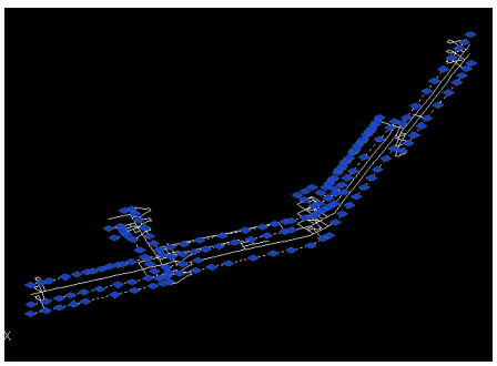
The basic structure for the 3D network is a group of connecting nodes that consists of x, y and z (height) values. The system will extract the values for the network analysis calculation.
Figure 1: Generated 3D CAD network
After we have established a 3D network for the indoor area, important information like IDs, distances, and potential candidates of nodes need to be retrieved, they are very important for the algorithm and can be extracted and assigned with proper IDs. By putting ID to each node, then the network is now applicable for Dijkstra’s algorithm.
The next step is to calculate the distance between the connected nodes (i.e. successor and predecessor nodes). It is not necessary to calculate the distance between all the nodes in the network as this will consume a lot of time. If node #1 is connected to node #2 and node #3, then the calculation will be based on those three nodes. To accomplish that, information on predecessor and successor nodes is important. To make computers understand which nodes are connected or not, therefore the network data file must be examined thoroughly. From here the data file will be examined in order to find the useful data and to determine the connected/reachable node.
Figure 2: The Shortest Route Calculation Windows
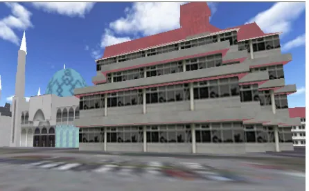
The second component of the system is the outdoor navigation. The 3D outdoor navigation is developed to navigate users from location A to location B and at the same time provides them with the real spatial information of the area e.g. shapes of buildings, structures, and other objects. As mentioned in the previous sections, 2D navigation systems are proven to be useful in locating the desired locations, but with 3D navigation system, users can see how the real environment looks like, marks out the possible navigational landmarks (i.e. distinct-permanent objects or buildings) and familiarized themselves with the routes. Figure 3 shows the outdoor environment in the navigation system.
This navigation system, like in most 3D games, allows users to walk around and explore the outdoor environment. In detail, the system provides users with the following functionality e.g. users can set a desired destination and navigate to it, and retrieves information of the surrounding buildings.
Figure 3: 3D buildings with real textures in the outdoor environment
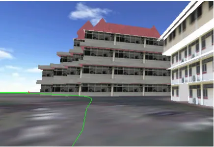
As mentioned before, the network analysis in this research is used to determine the shortest path from point A to point B based on the available paths. Users can select their destination and the system will determine the shortest path from the network. The path network is a combination of static and dynamic nodes. Static nodes represent the permanent paths existed in the real world and unlikely to change in the future unless there are no other ways meanwhile dynamic nodes marks the temporary paths that only available for a short period of time. With the dynamic nodes, users can add or delete nodes to create or update new paths in case there are changes occur in the real world. If the determined shortest path is somehow blocked or inaccessible, the algorithm will find another route to reach the destination. The shortest path will be marked with navigational markers (arrows, lines) to guide users to their selected destination as shown in the Figure 4.
Figure 4: The system navigates users along the shortest path
Since data is a very important element in GIS-related application, database plays a crucial role in storing and managing those data. The attributes database is then linked with its spatial objects (3D buildings). All stored data can be edited, added or deleted during the runtime. The database is developed using proper DBMS software so that users can manage (add, edit or delete) the stored data externally (using the DBMS itself) and easier to convert the database from or to other database format.
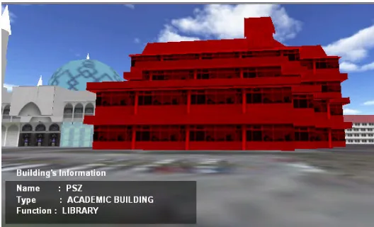
Spatial query on 2D environment is a common function in most GIS software. Since database can be incorporated with this program, it is possible for users to generate spatial query on a 3D objects in the 3D world. The engine’s ability to select 3D object via Point-and-shoot (clicking on the object) technique allow users to retrieve information related to the 3D buildings by clicking on the buildings. The information displayed is retrieved directly from the attributes database as mentioned in the previous section. Users can add, edit or delete the information during runtime or using the DBMS itself.
Figure 5: A simple 3D spatial query on the forefront building
5. CONCLUSIONS
3D engines are originally developed for 3D games. However, as the technology grows, we have seen their applications being implemented for 3D geoinformation. The previous discussions show that the 3D engine works for virtual navigation purposes (with some GIS functionalities e.g. spatial analyses). Again, it clearly shows that the 3D engine with GIS elements significantly enhanced the navigation system. For future work, the approach could be extended or incorporated with mobile devices and real-time positioning.
ACKNOWLEDGEMENTS
We would like to thank our research grant sponsor, Malaysian Ministry of Science, Technology and Innovation (MOSTI) and Universiti Teknologi Malaysia Research Management Centre (RMC) for their support (research grant number: Vote 79197).
REFERENCES
Balstrom, T. (2001). Identifying Least Cost Routes in Mountainous Terrain. Earth Science Research Institute, Redlands California, Unpublished.
Coors, V., C. Kray, K. Laakso, and C. Elting, (2004). Presenting Route Instructions on Mobile Devices. Book Chapter in “Geo-Visualization”, 2004. Book Sections, 2004.
Coors, V., J. Haist, and T. Reitz. (2006). A Web 3D Services for Navigation Applications. Innovations in 3D Geo Information Systems. Springer-Verlag Vol. 1, No.1, pp. 15-28.
Fritsch, D. (2003). 3D Building Visualization – Outdoor and Indoor Application. Photogrammetric week. 2003
Fritsch, D. and M. Kada (2004). Visualisation Using Game Engines. XX ISPRS Congress 2004, Commission IV. Istanbul, Turkey.
Meijers, M., S. Zlatanova and N. Pfeifer (2005). 3D Geoinformation Indoors: Structuring for Evacuation. Proceedings of Next Generation 3D City Models. Vol. 1, No.1, pp. 11-16.
Shi, P., and S. Zlatanova (2005). Evacuation route calculation of inner buildings. Geoinformation for disaster management. Springer-Verlag, Vol. 1, No.1, pp. 1143-1161.