FOR
SOUTHEAST
ASIA
An Economic Analysis
of Alternative Mangrove
Management Strategies
in
Koh Kong
Province, Cambodia
Camille
Bann
EEPSEA
RESEARCH REPORT
SERIES
ARCHIV
107388
EEPSEA is
supported by a consortiumof
donors and administered by IDRC.Mailing address: Tanglin PO Box 101, Singapore 912404.
Visiting address: 7th Storey RELC Building, 30 Orange Grove Road.
Tel: 65 235 1344 Fax: 65 235 1849
Comments should be sent
tothe
author, CamilleBann at Flat
5, 28 Charleville Road, LondonW14 9JH, United Kingdom, Tel/Fax: 44 171 381 3193
The Economy and Environment Program for South East Asia
(EEPSEA) was
established inMay 1993
to support research
and training in environmental andresource
economics.Its
objective is
to
enhance local capacityto undertake the
economic analysisof
environmentalproblems and policies. It uses a networking approach, involving courses, meetings, technical
support, access
to literature
andopportunities for
comparative research. Member countriesare Thailand, Malaysia, Indonesia,
the
Philippines, Vietnam, Cambodia, Laos, China,PNG
andSri Lanka.
EEPSEA's
funding ' is provided by a. consortiumof
donors. Asof
December1996,
thisSponsors Group consisted
of
IDRC (Canada), Sida (Sweden),Danida
(Denmark), CIDA(Canada), ODA (UK),
the
Ministriesof
Foreign Affairsof
Norway
and the Netherlands andthe MacArthur Foundation (USA).
EEPSEA
Research Reports are the outputsof
research projects supported by EEPSEA. Theyhave been peer reviewed and edited. In some cases, longer versions are available from the
authors.
EEPSEA
also issues a Special Papers Series, consistingof
commissioned papersemphasizing research methodology.
EEPSEA
is supported by a consortiumof
donors and administered by IDRC.Mailing address: Tanglin PO Box 101, Singapore 912404 Visiting address: 7th Storey RELC
Building, 30 Orange Grove Road Tel: 65 235 1344 Fax: 65 235 1849
ECONOMY AND ENVIRONMENT PROGRAM
FOR SOUTHEAST ASIA
An
Economic Analysis
of
Alternative
Mangrove
Management Strategies
in Koh Kong
Province, Cambodia
Camille Bann*
November 1997
* The research team would like to thank the Ministry of Environment in Phnom Penh and Koh Kong, and the
Provincial Government in Koh Kong for their support throughout this project
TABLE OF CONTENTS
page
EXECUTIVE SUMMARY 1
1.0 Introduction 5
2.0 Background 6
2.1 Mangrove Distribution in Cambodia 6
2.2 Mangrove Distribution in Koh Kong Province 7
2.3 Ecological Characteristics 8
2.4 Socio-Economic Data 9
3.0 Research Framework 10
3.1 Research Objective 10
3.2 Key Analytical Steps 11
3.3 Research Components 12
4.0 Identification Of Main Productive Uses and Ecological 12
4.1
Functions For Valuation
Total Economic Value 12
4.2 Measuring the Economic Value of Mangrove Characteristics 14
5.0 Household Survey 16
5.1 Summary of Socioeconomic Conditions in Study Area 16
5.2 Koh Kapik 18
5.3 Koh Sra Lao 19
5.4 Lamdam 20
6.0 Valuation of Mangrove Goods and Services 22
6.1 Values Selected for Economic Analysis 22
6.2 Direct Use Values 22
6.3 Indirect Use Values 42
6.4 Summary of Results 44
7.0 Economic Analysis of Shrimp Farms 45
7.1 Shrimp Farming in Koh Kong 45
7.2 Survey Results 49
7.3 Financial Cost- Benefit Analysis of Shrimp Farming 49
7.4 Environmental Cost Benefit Analysis (CBA) 51
7.5 Equity Concerns 53
7.6 Intensive versus Extensive Shrimp Farming 53
7.7 Improved Farming Practices and Sustainability 54
7.8 The Shrimp Farm Association in Koh Kong and Problems faced 54
8.0
by the Shrimp Industry
Selection and Specification of Management Options Management 57
9.0
Zoning System
Crop Cultivation in Upland Area and the Issue of Relocation 60
9.1 Wonk Ka Thak Village 61
9.2 Village Number 4 62
9.3 The Cost of Relocation 63
9.4 Conclusions and Recommendations 64
10.0 Conclusions and Recommendations 64
REFERENCES 68
page
Table 2.1 Protected Areas located in the Coastal and Marine Zone of Cambodia 8
Table 2.2 Estimated Rate of Mangrove Forest Degradation, 1995 8
Table 2.3 Key Socio-Economic Indicators 9
Table 3.1 Land Cover / Use in Peam Krasaop Wildlife Sanctuary 11
Table 4.1 Total Economic Value of Mangrove Resource 13
Table 4.2 Identification of Key Productive Use Values and Ecological Values 15
Table 4.3 Valuation Techniques Commonly used to Value the Different Value
Components of a Mangrove Resource
15
Table 5.1 Net Income per Household, Based on Survey Information 17
Table 6.1 Types of Fuel Used by Households 23
Table 6.2 Summary of Charcoal Value and Use 23
Table 6.3 Summary of Gas Value and Use 23
Table 6.4 Summary of Fuelwood Use and Value 24
Table 6.5 Use and Value of Fuelwood Assuming Charcoal Is Unavailable 24
Table 6.6 Net Benefits per Kiln Per Year 27
Table 6.7 Estimates of the Quantity of Mangrove Wood Used for Charcoal
Production
28
Table 6.8 Estimated Number of Trees in One Hectare of Mangrove Forest 29
Table 6.9 Key Data Relating to Charcoal Production in Koh Kong 30
Table 6.10 Cost of House Construction and Repair 31
Table 6.11 Summary of Expenditure on Fishing Equipment 33
Table 6.12 Koh Sra Lao: Summary of Benefits from Fishing, per Species 34
Table 6.13 Koh Kapik: Summary of Benefits from Fishing, per Species 35
Table 6.14 Lamdam: Summary of Benefits from Fishing, per Species 36
Table 6.15 Horsecrab: Collection Practices 37
Table 6.16 Stone Crab: Collection Practices 37
Table 6.17 Shrimp: Collection Practices 37
Table 6.18 Fish: Collection Practices 37
Table 6.19 Areas Fished 38
Table 6.20 Net Benefits per Village 38
Table 6.21 Net Value per Product 38
Table 6.22 Amount Borrowed 39
Table 6.23 Catch Effort by Gear Type 41
Table 6.24 Summary of Net Benefits 44
Table 6.25 Average Net Benefits to Households 45
Table 6.26 Results from Other Studies 46
Table 7.1 Data on Shrimp Farms in Cambodia 47
Table 7.2 Shrimp Farms in Koh Kong, 1996 Statistics 47
Table 7.3 Shrimp Production, Koh Kong 48
Table 7.4 Summary of the Size and Age of Shrimp Farm 49
Table 7.5 Relationship between Farm Productivity and Age 50
Table 8.1 Broad Description of Possible Management Zones for Mangroves in
Koh Kong Province
58
Table 8.2 Broad Management Options for Mangrove Resource in Koh Kong 59
Table 8.3 Benefits of Sustainable Management 60
Box 5.1 Logging Activities in Koh Kong 22
An
Economic Analysis
of
Alternative
Mangrove
Management
Strategies
in Koh
Kong Province, Cambodia
Camille Bann
Executive Summary
This report presents an economic analysis of the different uses of the mangrove resource of Koh Kong province, Cambodia. The objective of the study is to provide information on the economic benefits and operational practices of key activities in the area that might be employed in the identification of an economically optimal management strategy for the mangrove resource. A parallel objective of the study has been to train a team of Cambodians in survey techniques, data collection and analysis, and ultimately on
the economic appraisal of natural resource use.
Mangrove ecosystems are valuable, both in terms of their direct use and indirect
use values. Direct use values are the products and uses derived directly from the mangrove (e.g., fuelwood, food, construction materials, and use of the area as a site for human settlement). Indirect use values are the ecological services provided by mangroves which support indirectly economic activities. Ecologically, mangroves act as a natural barrier to shoreline erosion, reduce the effects of storm surges and flooding, maintain water quality, and support a wide range of wildlife. All of these ecological functions
indirectly support economic activities and therefore are of value.
Perhaps the most well-known ecological service provided by mangroves is the
support they provide to local and commercial fisheries. Mangroves act as nurseries and
shelters for many species of commercially important finfish and crustaceans.
The mangrove areas in Koh Kong province cover an area of 63,700 hectares and
have been described as ecologically and economically significant to Cambodia and all
other countries situated around the Gulf of Thailand. Furthermore, this environment is the only site in all of continental Southeast Asia considered appropriate for the establishment of a coastal biosphere reserve. The mangrove forests and related environments of Koh
Kong are therefore of vital international importance for nature conservation.
Most of the mangrove areas in Cambodia have been designated within the protected areas system, such as Peam Krasaop Wildlife Sanctuary. Koh Kapik and associate islets situated within Peam Krasaop Wildlife Sanctuary, have been nominated as
a wetland of international importance under the Ramsar Convention. However, management plans for these areas are yet to be developed.
As for other mangrove areas in Cambodia, the mangroves of Koh Kong, which currently support a number of households, are threatened largely by the clearing of mangroves for intensive shrimp farms, and for commercial and domestic charcoal production. Charcoal production, which is illegal, has recently been stopped by the provincial government, leaving a number of families unable to support themselves, even
through fishing due to declines in fish productivity. No other viable employment alternatives
In certain circumstances using the mangrove resource for productive purpose, such as charcoal productive or shrimp farming, may be justified. Typically, however, such
decisions are based narrowly on the potential financial returns. The alternative uses of the mangrove resource and the many important environmental values of mangroves that are
subsequently lost, often irreversibly, as a result of these productive activities are ignored.
This is a serious oversight in cases where the economic value of a mangrove's resources
and natural services exceed the gains from productive uses.
One reason why the full range of mangrove values are not considered in the appraisal process, is that many of these values are not sold in conventional markets. They
therefore do not have market prices (e.g., forest products such as fuelwood and the storm
protection function of a mangrove). This shortcoming often means that decisions are
biased towards development options whose output is marketed and therefore easily measured (e.g., shrimp farming). However, such a partial evaluation of the mangrove ecosystem runs the risk of supporting development options that are in fact not economically optimal.
In order, therefore, to make rational management decisions for the mangroves of
Koh Kong, the full range of benefits and costs associated with the different uses of the
mangrove ecosystem must be evaluated. Such a comprehensive approach can provide information to decision makers on the environmental and social costs and benefits of different management options, and is therefore one important tool for meeting the objective
of sustainable management.
This study presents an economic evaluation of the two key uses of the mangrove resource in Koh Kong - local community use and commercial shrimp farming.
Since local people are heavily dependent on the mangrove resource, community- based alternatives to unsustainable and destructive practices are seen as central to the success of any management strategy in Koh Kong.
A survey of 90 households was undertaken in three villages within Koh Kapik - the study area (Koh Sra Lao, Koh Kapik, and Lamdam) to provide information on the traditional
uses of the mangrove area by local communities. The research focused on the economic
valuation of non-timber forest products collected by households from the mangrove area:
fuelwood, construction materials, and crabs, shrimp, fish and snails. The charcoal industry, which was active at the time of survey, was also studied.
The survey results show that 94% of the population are in-migrants, attracted to the area by the potential returns from fishing and charcoal production at a time when population and hence resource exploitation was low. The greatest influx into the area
occurred during the period 1985-90. A high proportion of households are now in debt and
unable to leave the area due to lack of funds.
Nearly 90% of households are dependent on fishing for their livelihood. However,
fish productivity has reportedly declined dramatically in recent years due to the increased
number of fishers, the loss of mangrove areas due to the construction of shrimp farms, and
water pollution from these farms. Households in Koh Sra Lao claim to have turned to charcoal production because of low fishing yields, while many villagers in Lamdam are
reportedly involved in logging activities in nearby Koh Kong Island. If these explanations
are correct a linkage can be made among shrimp farming, declines in fish yields, and
changes in the activities of local people resulting in new and additional stresses on the resource base.
EEPSEA Research Report Series
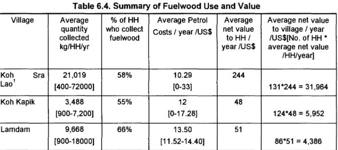
Local fishing benefits are estimated at US$84 per hectare (the benefits from
commercial fishing have not been estimated). Fuelwood is valued at US$3.50 per hectare. Valuation of the many indirect functions of the mangrove resource was not possible due to data limitations. However, a qualitative assessment of these indirect values reveals that many are considered to be of great importance and value, such as the storm
protection function of the mangroves and biodiversity benefits.
Following the closure of the charcoal kilns, the Government intends to fully regenerate the mangrove forest, and then regulate and legalise the charcoal industry. It is recognised that local people need to produce charcoal because they cannot afford to buy
fuel. However, what level of charcoal production would be sustainable for the area is as yet
unclear, and would require careful consideration in any future management plan.
Results from this study suggest that sustainable charcoal production could provide benefits of US$413 per hectare. Charcoal production would only be allowed in areas where the mangrove has already been disturbed or replanted, and not in areas of high ecological
value such as within Koh Kapik.
An important result of this study, is that on a narrow financial analysis alone (without accounting for the wider environmental and social costs imposed by the industry) shrimp farming in Koh Kong is unprofitable and unsustainable. Farms are typically abandoned after five years of operation.
While 50% of farms made a profit in the past year, overall shrimp farms in the area
suffered an average loss of US$1,103 per hectare. Largely due to problems with disease (associated with poor water quality management), it is rare for farms to have two
successful harvests a year, and in some cases both harvests have failed. Individual farms have reported losses ranging from US$40,000-$240,000.
The real costs of shrimp farming are in fact much higher than this. The analysis does not account for the environmental costs associated with shrimp farming such as loss
of mangrove areas, water pollution, and the associated declines in fish productivity. Social equity issues are also of top concern because many local people feel marginalised by the shrimp farms, and because the benefits from shrimp farming are gained largely by Thai
investors, not by Cambodia.
Future management of the shrimp farming industry requires a focus on sustainable practices, not short-term profit, and greater involvement of the local community.
An integrated management strategy for the mangrove areas needs to be developed which: safeguards the important ecological functions of the mangroves; allows sustainable traditional productive uses of the mangrove by local communities;and supports a sustainably managed commercial shrimp farming industry in designated areas. A zoning system is proposed consisting of a core area representing areas of high ecological value such as Koh Kapik. This area could be afforded total protection, or permitted to be utilized
for sustainable local use. The remaining area--the multiple use area--could be used for sustainable traditional uses, and shrimp farming and charcoal production in appropriately identified zones.
A further issue, supported by local authorities, is that of relocating families out of the sensitive mangrove areas. Land is available in upland areas in the province where crop cultivation is possible alongside fishing. The standard of living in the villages within Koh
families. Households in the area have thus expressed an interest in relocation, if land is allocated to them. While an in-depth assessment of the suitability of the assigned location for relocation was not possible during the time frame of this study, the possibility of voluntary relocation is not completely ruled out. Relocation may be necessary to afford complete protection of ecologically valuable areas and may potentially improve the living
standards of the local people. Relocation compensation (support) is estimated at US$1,940
per household to cover the cost of house construction and living expenses up to the first harvest.
The mangroves of Koh Kong are central to the livelihood of coastal households, are
of high ecological importance and represent a base for sustainable economic exploitation
if
carefully managed. These substantial benefits of the mangrove ecosystem will be forgone
if the mangrove areas are lost or damaged through uncontrolled resource use and
EEPSEA Research Report Series
1.0 INTRODUCTION
There are estimated to be 85,100 hectares of mangroves in Cambodia in fringe coastal areas along the Gulf of Thailand (Mekong River Commission, UNDP, FAO, 1994).
The vast majority (63,700 hectares) are located in Koh Kong Province.
While the total area of mangrove forest in Cambodia is small compared to
surrounding countries in the Gulf of Thailand, these forests, particularly in Koh Kong
Province, have been relatively undisturbed until recently. However, Cambodia's mangroves
are now under intense pressure from competing resource uses. Two important threats to
the mangrove resource are the clearance of mangrove areas for intensive shrimp farming
and charcoal production'. Neighbouring countries such as Thailand and Vietnam have
seen widespread destruction of their natural coastal resources as a result of unmanaged exploitation. Sound management strategies for Cambodia's mangrove areas are urgently needed to avoid a similar outcome.
Mangrove ecosystems are valuable, both in terms of their direct use and indirect use values. Direct use values are the products and uses derived directly from the mangrove (e.g., fuelwood, food, construction materials, and use of the area as a site for human settlement). Indirect use values are the ecological services provided by mangroves which indirectly support economic activities. Ecologically, mangroves act as a natural barrier to shoreline erosion (and stabilize fine sediments, thereby helping coasts to accrete), reduce the effects of storm surges and flooding, maintain water quality, and support a wide range of wildlife. All of these ecological functions indirectly support economic activities and therefore are of value. For example, the storm protection function of a mangrove may have indirect value through the protection afforded to coastal property
and economic activities.
Perhaps the most well-known ecological service provided by mangroves is the support they provide to local and commercial fisheries. Mangroves are well-known for their
high biological productivity and their consequent importance to the nutrient budget of
adjacent coastal waters. They export organic matter, mainly in detritus form (leaf litter) to
the marine environment, thereby providing a highly nutritious food source for animals found in the mangrove areas as well as for those in neighbouring estuarine and marine
ecosystems. Mangroves also support off-shore fisheries by acting as nurseries and
shelters for many species of commercially important finfish and crustaceans.
Often, local coastal communities are dependant on the natural resources that mangroves provide in the form of food, firewood, construction materials and medicine, and on their ecological services and functions for their livelihood. The impact on local
livelihoods of activities that damage mangrove areas is therefore a fundamental consideration in the design of management plans. This is certainly a key factor in Koh
Kong, since local people are heavily dependent on the mangrove resource. Community-
based alternatives to current unsustainable, destructive, and in some cases inequitable practices are thus central to the success of any management strategy in Koh Kong.
In certain circumstances, using the mangrove resource for productive purpose, such
1 Other threats to mangroves in Cambodia include: Klim chan production; clearance for salt farms; and uncontrolled exploitation for firewood. Klim Chan is a sweet smelling perfume produced from a certain type of tree found in the mountain areas of Koh Kong. Mangrove wood is burned in Klim Chan kilns in order to produce the perfume. There were estimated to be 37 Klim Chan kilns (MOE/IDRC, 1994). Each kiln uses, on average,
as charcoal production or shrimp farming, may be justified. Typically, however, such decisions are based narrowly on the potential financial returns. The alternative uses of the mangrove resource and the many important environmental values of mangroves that are
subsequently lost, often irreversibly, as a result of these productive activities are ignored.
This is a serious oversight in cases where the economic value of a mangrove's resources
and natural services exceed the gains from productive uses.
One reason why the full range of mangrove values are not considered in the appraisal process, is that many of these values are not sold in conventional markets.
These values/products therefore do not have market prices (e.g., forest products such as
fuelwood and the storm protection function of a mangrove). This shortcoming often means that decisions are biased towards development options whose output is marketed and
therefore easily measured (e.g., shrimp farming). However, such a partial evaluation of the mangrove ecosystem runs the risk of supporting development options that are in fact not economically optimal.
In order to make a rational choice between conservation and development options, or between a decision to halt, modify or continue with an activity that is inflicting damage
on a mangrove, alternative management options must be properly evaluated. This entails a comprehensive cost benefit analysis (CBA) which incorporates the full range of benefits
and costs associated with the different uses of the mangrove ecosystem. A comprehensive
CBA can provide information to decision makers on the environmental and social costs and
benefits of different management options, and is therefore one important tool for meeting the objective of sustainable management.
2.0 BACKGROUND2
2.1 Mangrove Distribution in Cambodia
The Cambodian coastline extends some 435km between the Thai border and the Vietnamese border. It includes a large estuary in the northern part (Koh Kong Province) and the great bay of Kompong Som. Three provinces and one independent resort city lie
along the coastline with a population of slightly more than 675, 000 inhabitants. Of the total populace, 476, 000 reside in Kampot Province, 120, 000 in Kompong Som, 79,000 in Koh
Kong, and the rest in Kep Resort City. Four main islands (Koh Kong, Koh Rong, Koh Rong
Sanlem, and Koh Thmey) and a number of small islands are located nearshore. The three
main islands off-shore are Koh Tang, Koh Pring and Koh Polowaii. The total Exclusive
Economic Zone (EEZ) area is estimated to be 42,000 km2, about 23% of Cambodia's land
area3.
Mangrove forests occur in Cambodia's three coastal Provinces on the Gulf of Thailand--Koh Kong (where they are most abundant), Kompong Som (where there are only
a few patches on the shore), and Kampot. While mangrove forests spread almost all along the coastline, large, and dense forests are found at the main estuarine areas--Peam
Krasaop, Andong Tuk, Sre Ambel, Chak Sre Cham, and the Delta of Prek Kampot.
It was estimated in the past that mangrove forest covered only 37,000 ha (Chea Peng Chheang, Department of Fisheries). The Land Cover maps published by the Mekong
2
This Section is based on ADB, 1996
3 Cambodia's coastline and EEZ is relatively small compared with neighbouring countries. Thailand has a
coastline of 3, 219 km long and an EEZ of 85, 800 sq km, while Viet Nam has a coastline of 3,444 km long and
EEPSEA Research Report Series
River Commission/UNDP/FAO (1994), however, show that in 1992/3, the mangroves consist of about 85,100 ha. Of these land area, 63,700 ha are located in Koh Kong
Province, 13,500 ha in Sihanoukville, and 7,900 ha in both Kampot Province and Kep
Resort City.
A degree of uncertainty surrounds current estimates on Cambodia's mangroves. The data were derived largely from a 1:25,000 aerial photographs taken in December 1994
that have not been systematically ground truthed due to safety and security constraints.
The GIS land use maps that have been made by interpreting the 1991 aerial photographs
were not systematically ground truthed either. Reports were based on small scale projects and on on-site reconnaissance of selected areas that are accessible by boat or road; there
are very limited aerial reconnaissance in the vicinity of Koh Kong province.
2.2 Mangrove
Distribution
in Koh Kong ProvinceKoh Kong province covers an area of 11,160 km2 and borders Thailand to the west,
Pursat province to the north, Kompong Speu province to the northeast, Kampot and Kompong Speu province to the east and southeast and the South China Sea and Thailand
to the south and south west. The coastline is approximately 260 km long. The Cardamon Mountain range surrounds one side of the the coast of Koh Kong province while islands
and ocean are on the other side. Koh Kong is divided into seven districts: Dongtung,
Mondulsema, Koh Kong, Kirisakor, Botumsakor, TmarBing, and Sre-Ambul.
Koh Kong has the vast majority of mangrove forests in Cambodia, with some of the
last remaining areas of pristine mangroves in Southeast Asia. Mangroves are spread along Dongtung, Mondulsema, Koh Kong, Kirisakor, Botumsakor, and Sre-Ambul districts.
The mangrove areas in Koh Kong province have been described as ecologically
and economically significant to Cambodia and all other countries situated around the Gulf of Thailand. Furthermore, this environment is the only site in all of continental Southeast Asia considered appropriate for the establishment of a coastal biosphere reserve. The mangrove forests and related environments of Koh Kong are therefore of vital international importance for nature conservation.
Most of the mangrove areas have been designated within the protected areas system under the Royal Decree Creation and Designation of Protected Areas' signed on
November 1, 1993 by King Sihanouk (Table 2.1). These protected areas include the Peam Krasaop Wildlife Sanctuary (31,022 ha), and Botum Sakor National Park (171,250 ha). In addition, Koh Kapik (12, 000 ha) and associate islets situated within Peam Krasaop Wildlife Sanctuary, have been nominated as a wetland of international importance under the Ramsar Convention (AWB 1994). All of these areas are under the responsibility of the Ministry of Environment (MOE). Management plans for these areas are yet to be developed.
In recent years, mangrove forest areas have been severely degraded. The exact extent of this degradation is not known. Table 2.2 presents the estimates of the rate of mangrove forest degradation in Cambodia. In Koh Kong, most of the degraded areas are in Mondulsema and Dongtung districts where mangrove areas have been converted to
intensive shrimp farms (Dongtung District) and where extensive cutting for charcoal production has occurred. Degradation is also evident in Peam Krasaop Wildlife Sanctuary.
Table 2.1. Protected Areas located in the Coastal and Marine Zone
of
CambodiaName Area (ha) Province
National Parks
Phnom Bokor 140, 000 Kampot
Kep 5, 000 Kampot
Ream (Preah Sihanouk) 15, 000 Kompong Som
Botum Sakor 171, 250 Koh Kong
Kirirom 35, 000 Koh Kong, Kampong
Speu Wildlife Sanctuaries
Peam Krasaop 23, 750 Koh Kong
Phnom Samkos 333, 750 Koh Kong
Aural 253, 750 Koh Kong, Pursat,
Kampong Channang,
Kampong Speu Multiple Use Mgt. Areas
Dong Peng 27, 700 Koh Kong
Source: ADB, May 1996
Table 2.2. Estimated Rate
of
Mangrove Forest Degradation, 1995Province/City Total Areas (ha) Area of
degradation (ha) Density degradation (%) Koh Kong 63,700 1,500 40-50 Kompong Som 13, 500 800 35-40 Kampot 7, 900 400 50-60
Source: ADB, May 1996 2.3 Ecological Characteristics
An initial field study (DNCP/MOE 1995) found 42 species of trees and shrubs
belonging to 20 families in the mangrove forest of Koh Kong. The most dominant species
are of the family Rhizophaceae (species Mucronata and Apiculata); family Combretaceae
with genera Lumnitora; and, family Avicenniacae with genera Avicennia.
Mangrove forest zonation in Koh Kong is believed to be similar to plant community structure in Chattaburi province Thailand. The edges of the estuaries and canals are
dominated by Rhizophora apiculata and R. mucronata. Further inland are Avicennia and
Bruguiera followed by Xylocarpus, Ceriops and Lumnitzera. Finally, a combination of Nypa
fruticans and others can be found in the transitional zones between true mangroves at the seaward edge and inland forest (rear mangroves) which are dominated by Melaleuca trees.
EEPSEA Research Report Series
2.4 Socio-Economic Data
Koh Kong has an estimated population of 80,000. Population density in the province is low compared to other parts of the country, especially provinces in the Mekong
Basin. Dongtung (where Koh Kong provincial town is located) and Sre Ambul districts have
the highest population.
Approximately 54% of the population are adults (16 years of age and older) and an
estimated 51% of the provincial population is composed of women. This is different from other provinces in Cambodia where women represent 54-60% of the adult population. There are approximately 119 villages with an average of 650 persons, excluding 7-10 families of resettled people. In-migration is an important issue in Koh Kong because of
perceived economic opportunities available there.
According to local population statistics, 90% of the population are ethnic Khmer,
5.58% Muslim, 2.34% ethnic Thai, 1.84% ethnic Vietnamese, and 0.16% Chinese. These figures demonstrate that, contrary to popular belief, Koh Kong province is not populated by
large numbers of ethnic Thais. However, there is a strong Thai influence in the form of language, foreign investment, and currency use.
The main types of employment in the Koh Kong are: fishing, farming, government staff, collection of non-timber forest products (NTFP), trading, woodcutting, and charcoal production. Most farmers in Koh Kong province are located in Dongtung and Sre-Ambul
Districts. Many coastal people are farmers as well as fishermen.
Khmers living along the coast have many types of jobs, but are mainly fisherfolk, government staff, and up to recently--charcoal producers. A much smaller population of Thais is also involved in most professions. Most of the Muslim population are fishermen, while most Vietnamese are traders and labourers.
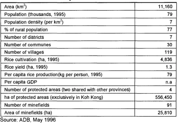
Table 2.3. Key Socio-Economic Indicators
Area (km2) 11,160
Population (thousands, 1995) 79
Population density (per km2) 7
% of rural population 77
Number of districts 7
Number of communes 30
Number of villages 119
Rice cultivation (ha, 1995) 4,836
Rice yield (ha, 1995) 1.3
Per capita rice production(kg per person, 1995) 79
Per capita GDP n.a
Number of protected areas (two shared with other provinces) 4
ha of protected areas (exclusively in Koh Kong) 556,450
Number of minefields 91
Area of minefields (ha) 25,810
3.0 RESEARCH FRAMEWORK 3.1 Research Objective
The objective of the study was to provide information on the economic benefits and
operational practices of key activities in the area. This information is important for the identification of an economically optimal integrated management strategy for the mangrove resource in Koh Kong Province.
The Study Area: Koh Kapik
The main study area is Koh Kapik, the proposed Ramsar site. Research on this area may be used as basis for suggesting an optimal management strategy for the total mangrove area of Koh Kong. Koh Kapik is close to the Thai border, southeast of Koh Kong
town. The area (12,000 hectares) includes all of Koh Kapik with associated islets together
with part of the mainland between Prek Thngo and Prek Khlang Yai. A much wider area which includes this site is a designated Wildlife Sanctuary--Peam Krasaop (31, 022 ha).
Table 3.1 presents land cover and use in Peam Krasaop Wildlife Sanctuary (refer to
Coastal Zone Land Use Cover Map).
There are three villages in the area -- Koh Kapik, Koh Sra Lao, and Lamdan. All of these villages are dependent on the mangrove resource for their livelihood. The area of
Koh Kapik is valuable for the large area of mangroves and rear mangrove communities which are representative of the coasts of Cambodia and Thailand and which have been largely destroyed elsewhere. Although some areas are under threat of disturbance, there
are large areas of old growth mangroves such as Rhizophora apiculata and Lumnitzera
littorea with an abundance of epiphytes.
Three major vegetation types have been identified (AWB/SSE 1994):
Mangrove: Most of the members of the mangrove community are characteristic of areas which are inundated only at some high tides and where there is a large degree of freshwater influence. The islands and creeks are typically fronted by Rhizophora apiculata, one of the most common of the mangrove species present, and stands of Nypa palms.
Immediately behind this fairly narrow strip of Rhizophora is an interesting mixture of other
mangrove species, the most common of which are: Brugiera gymnorrhiza, B. sexangula, Ceriops tagal, Lumnitzera littorea, Heritiera littoralis, Xylocarpus granatum, Hisiscus tiliaceus, Phoenix palludosa, Acrosthicum speciosum, Aegialitis sp. and, Acanyus sp.
'Rear mangrove' community: On some of the islands and on the mainland between Prek Khlang Yai and Prek Thngo, the mangrove community forms a narrow band.
It is followed by a community above the high tide mark and probably only subject to
freshwater inundation during the wet season. This community is dominated by Melaleuca leucodendron.
Beach strand vegetation: At the south side of Koh Kapik, and on the sandy areas of some of the islands, there are small areas of typical beach strand vegetation dominated
EEPSEA Research Report Series
Table 3.1. Land Cover / Use in Peam Krasaop Wildlife Sanctuary
Description of Land Cover Hectare
Mangrove Forest
Mangrove forest 0-5m 2,025
Mangrove forest 5-15m 2,018
Mangrove forest greater than 15m 4,145 Cleared mangrove forest area (Rhizophora) 2,634 Upper mangrove forest (rear mangrove forest) 25
Mangrove fern 116
Other Vegetation Cover
Nypa 357
Melaleuca leucadendron / Rear mangrove 2,196
Broad leaf evergreen forest 4,279
Secondary forest 3,254
Bushland 163
Bushland and trees/low density 18
Shrubland 153
Shrubland and scattered trees 69
Grassland 672
Grassland and scattered trees 338
Grassland and trees / low density 72
Agricultural Land
Orchard 103
Upland crops 29
Rice field 171
Other land use / land cover
Active shrimp farm 219
Abandoned shrimp farm 292
Charcoal kilns (aggregate area) 28
Villages 3
Temple/Pagoda 44
Beaches 7,547
Permanent water body 51
TOTAL 31,022
Source: Integrated Resource Information Centre, Phnom Penh (IRIC 1997)
3.2 Key Analytical Steps
(i) Identification of key productive uses and ecological functions of the mangrove resource which may be included in the economic valuation process (Section 4).
(ii) Economic valuation of traditional uses of mangroves and qualitative discussion
of ecological functions (Section 6)
(iii)Economic analysis of shrimp farming (Section 7)
(iv) Selection and specification of management options that are technically and
politically feasible, and generate sustainable returns from the resource base (Section 8).
(v) Discussion of crop cultivation in upland areas and the issue of relocation (Section 9).
3.3 Research Components
(i) A survey of 90 households in three villages within Koh Kapik area was conducted to provide the primary data needed to quantify the scale and value of traditional mangrove uses. Both marketed and unmarketed goods are included
in the analysis. The survey included research on the charcoal industry in Koh
Kong which was still active at the time of survey.
(ii) Survey of eight shrimp farms in the area to provide information for economic
evaluation of shrimp farming in Koh Kong.
(iii) Forest inventory to determine number of trees in one hectare of forest to provide
information on the mangrove area required to produce a given quantity of charcoal.
(iv) Market survey to provide qualitative information for economic valuation.
(v) Survey of households in upland areas in order to assess the viability of relocation.
4.0 IDENTIFICATION OF MAIN PRODUCTIVE USES AND ECOLOGICAL FUNCTIONS FOR VALUATION
4.1 Total Economic Value
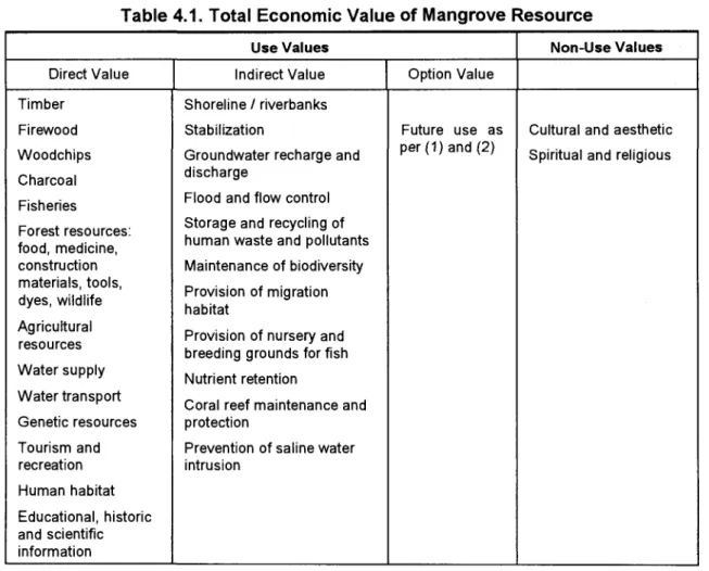
The Total Economic Value (TEV) of a natural resource such as mangroves provides a framework for valuation (Table 4.1). TEV comprises direct use value, indirect use value,
option value, and existence value. The relative importance of the individual components of
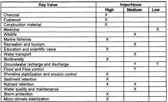
TEV for a given mangrove area is site specific. An understanding of the study area is therefore necessary to identify key values that should, where possible, be included in the economic analysis. The key productive use values and ecological values for Koh Kong are
identified in Table 4.2 and discussed in more detail in Section 6.
4.1.1 Direct use value
Direct use values are the values derived from the direct use or interaction with a mangrove's resources and services. Direct use values include both consumptive uses of a mangrove's resources (e.g., fuelwood collection, hunting, and fishing) and non-
consumptive uses of a mangrove's 'services' (e.g., recreation, tourism, and in-situ research and education). Direct use of mangroves could involve both commercial and non-
commercial activities. Non-commercial activities are often very important for the
subsistence needs of local populations. 4.1.2 Indirect use value
Indirect use values are the indirect support and protection provided to economic activity and property by the mangrove's natural functions, or regulatory 'environmental'
services. For example, the storm protection function of a mangrove system may protect
agricultural production, infrastructure, properties, and even human lives. Groundwater recharge might replenish aquifer supplies in the area used for domestic agricultural and
EEPSEA Research Report Series
Table 4.1. Total Economic Value
of
Mangrove ResourceUse Values Non-Use Values
Direct Value Indirect Value Option Value
Timber Shoreline / riverbanks
Firewood Stabilization Future use as Cultural and aesthetic Woodchips Groundwater recharge and per (1) and (2) Spiritual and religious Charcoal discharge
Fisheries Flood and flow control Forest resources: Storage and recycling of
food, medicine, human waste and pollutants
construction Maintenance of biodiversity materials, tools,
Provision of migration
dyes, wildlife
habitat
Agricultural Provision of nursery
and
resources
breeding grounds for fish Water supply
Nutrient retention Water transport
Coral reef maintenance and Genetic resources protection
Tourism and Prevention of saline water recreation intrusion Human habitat Educational, historic and scientific information 4.1.3 Option value
Option value is a type of use value in that it relates to future use of mangroves. Option value arises because individuals may value the option to be able to use a mangrove some time in the future. Thus there is an additional 'premium' placed on preserving a mangrove system and its resources and functions for future use. Option value may be
particularly important if one is uncertain about the future value but believes it may be high,
and if current exploitation of the mangrove or its conversion to other uses results in
irreversible effects. For example, mangrove resources may be underutilized today but may have a high future value in terms of scientific, educational, commercial and other economic
uses. Similarly, the environmental regulatory functions of the mangrove ecosystem may
become increasingly important over time as economic activities develop and spread in the region.
Bequest values are a special category of option values. Such values arise from individuals placing a high value on the conservation of mangroves for future generations to
use. The motive is the desire to pass something on to one's descendants. Bequest values
may be particularly high among the local populations currently using or inhabiting a mangrove in that they would like to see their way of life and culture that has 'co-evolved' in conjunction with the forest passed on to their heirs and future generations.
Option and bequest value are difficult to assess as their estimation involves some assumptions concerning future incomes and preferences, as well as technological change.
4.1.4 Non-use values
Non-use values are derived neither from current direct nor indirect use of the mangrove. There are individuals who do not use the mangrove but nevertheless wish to
see them preserved 'in their own right'. These 'intrinsic' values are often referred to as
existence values. Existence value is derived from the pure pleasure in something's existence, unrelated to whether the person concerned will ever be able to benefit directly or indirectly from it. Existence values are difficult to measure as they involve subjective valuations by individuals unrelated to either their own or other's use, whether current or future. However, several economic studies have shown the 'existence value' of ecosystems constitutes a significant percentage of total economic value.
4.2 Measuring the Economic Value
of
Mangrove CharacteristicsValuing a mangrove resource essentially means valuing the characteristics of a system (see TEV framework in Table 4.1). The purpose of the economic analysis is to
make the total economic value of the mangrove resource explicit (in monetary terms), such
that the value of the resource may be incorporated more fully in the economic assessment process. This is necessary for a fair comparison to be made between alternative uses of the mangrove resource. The different valuation techniques that might be employed to value the different characteristics of a mangrove are summarised in Table 4.3.
The direct use values of mangrove resources and services are relatively
straightforward to measure, usually involving the market value of production gains. The indirect use value of an environmental function is related to the change in the value of production or consumption of the activity or property that it is protecting or supporting.
However, as this contribution is typically not marketed and is only indirectly connected to
economic activities, indirect use values are difficult to value. The first step to valuation is
deciding whether the service supports economic productivity or is protecting economic activities and property. Where economic production is being supported, the value of these functions can be measured through changes in productivity
-
in other words, the value of productivity gained (or lost) of marketed goods and services as a result of environment improvement (degradation). Where economic activity or property is being protected, the value can be expressed in terms of preventive expenditures that would be required if the function were degraded or irrevocably disrupted; the damage costs avoided by these functions operating normally; the costsof
replacing these functions with alternatives; or the relocation costs required if these functions were lost (Barbier et al. 1991).Ideally, when analysing the economic benefits of alternative management options,
the TEV of the mangrove resource under each option would be assessed and compared.
However, valuing all the characteristics of the mangrove resource would be time
consuming and costly, and in certain cases impossible, given data limitations. Furthermore, valuation of all benefits is usually only necessary under certain circumstances (when it is necessary to determine whether the mangrove should be preserved or to determine its total contribution to the welfare of society). Where the research objective is to determine if
an alternative use or conversion of mangrove resources should proceed, partial valuation of a mangrove's net benefits is typically sufficient. That is, valuation of a few key mangrove benefits may be enough to indicate that the loss to society (foregone benefits) of
converting or diverting mangrove resources is not economically justifiable.
It is therefore important to identify the key productive uses and ecological function
of the mangrove system under study, in order that research efforts may be concentrated on
EEPSEA Research Report Series
example where the required physical data are unavailable. In such cases, a detailed qualitative assessment should be provided. Based on the information currently available,
an assessment of the importance of the direct and indirect values of the mangroves of Koh
Kong is presented in Table 4.2.
Table 4.2. Identification
of
Key Productive Use Values and Ecological ValuesKey Value Importance
High Medium Low
Charcoal X Fuelwood X Construction material X Medicine X Wildlife X Marine fisheries X
Recreation and tourism X
Education and scientific value X
Water transport X
Biodiversity X
Groundwater recharge and discharge ? ?
Flood and Flow control ?
Shoreline stabilization and erosion control X
Sediment retention X
Nutrient retention X X
Water quality and maintenance X
Storm protection X
Micro climate stabilization X
Table 4.3 Valuation Techniques Commonly used
to
Value the Different Value Componentsof
a Mangrove ResourceTEV Valuation Technique
Direct Use Values
Use ValuesTimber Market analysis
NTFPs (e.g. fish, nypa, medicine, traditional Market analysis, price of substitutes, indirect hunting and gathering) substitution approach, indirect opportunity cost approach, value of changes in
productivity, barter exchange approach Travel cost method, hedonic prices Educational, recreational and cultural uses Hedonic prices, [replacement cost] Human habitat
Indirect Use Values
Erosion prevention (shoreline) Damage costs avoided Erosion prevention (riverbanks) Preventive expenditure Storage and recycling of human waste and Value of changes in production
pollutants [Relocation costs]
Maintenance of biodiversity [Replacement costs] Provision of migration habitat
Provision of nursery grounds Provision of breeding grounds Nutrient supply
Nutrient regeneration
Coral reef maintenance and protection
Option Value Contingent valuation method
5.0 HOUSEHOLD SURVEY
There are three villages (Koh Sra Lao, Koh Kapik, and Lamdam) and approximately 581 households in Koh Kapik. A survey of 90 households (Koh Kapik village: 36
households; Koh Sra Lao: 36 households; and, Lamdam: 18 households) representing
15% of the total was undertaken in December 1996. The survey was necessary to provide the information needed to quantify the importance of the mangrove area for traditional
uses4i. Information on the three study villages based on the survey results is presented
below.
5.1 Summary
of
Socioeconomic Conditions in Study AreaPopulation has grown rapidly in the three study villages over the last 15 years,
largely as a result of in-migration. Economic factors explain this trend, with migrants attracted by the high potential returns from fishing and charcoal production in what was,
prior to the late 80s, an area of low population and resource exploitation. Overall, only 6% of households originate from Koh Kong Province. The remaining population originates from 13 of the 18 provinces in Cambodia5. The majority (36%) originate from the other coastal provinces of Kampot and Sihanoukeville, and from Kandal province and Phnom Penh 22%
(Diagram 1).
A high percentage (76%) of migrants came to the area during the period 1980-1995.
The greatest influx of people was between 1985-90 (37%). Prior to 1980, in-migration was relatively low (3%), and since 1995 it has fallen to 10% (Diagram 2).
By comparison, out-migration is minimal. It is estimated that 2% of the population
has moved to other areas in the past 5 years, either to study or to get married6. A key
reason for the lack of movement out of the area, despite the low living standards now facing the majority of households, is the fact that a lot of people lack the resources to move
being heavily in debt.
An estimated 87% of households are dependent on fishing for their livelihood (for 65.5% of households fishing is their only form of income). At the time of survey 6% of households were involved in charcoal production (only in Koh Sra Lao) and 8% were involved in other activities such as trading fish or general products (Diagram 3). As of January 1997 no charcoal kilns were in operation in Koh Sra Lao and it is assumed that ex-
charcoal producers will now turn to fishing as their only alternative means of income. This increases to 93% the number of households dependent on fishing.
As many as 90% of households (excluding charcoal producers) claim that it was harder to fish than it was five (5) years before. The main reasons are: more fishermen
(40%), loss of mangrove area (31 %), water pollution caused by shrimp farms (16%), illegal
fishing, and use of modern fishing equipment (16%), and loss of mangroves due to
charcoal production (3%). See Diagram 4).
Given the declines in fish yields, interviewees were asked what alternatives existed
to fishing and charcoal production. The majority felt that there are no alternatives
4 Preliminary information gathered on an initial field visit (July 26-31 1996) was used to design the main survey
questionnaire. At this time a questionnaire was pre-tested on three households in Koh Sra Lao village.
5 Cambodia has 18 provinces, and one commercial city Sihanoukville (also known as Kompong Som) 6 Education in Koh Kong province is poor. There are only 47 schools in the province (IDRC/MOE, 1995).
EEPSEA Research Report Series
(66%),15% of households said they would return to their birth village, 10% would farm in upland areas, 3% would collect upland wood, and, 4% would trade (Diagram 5). Those who would return to birth village are typically those who still have land in their birth village and
are not in debt. Thus, they can afford to make the move.
Only 15% of households claim not to face any economic problems. The main
economic problems faced by other families include: poverty/low standard of living (34%);
loss or lack of fishing equipment (28%); declining fish productivity (18%); health problems
(10%); food security (9%); illegal check points (8%); and other reasons such as too many
children and shortage of water in the dry season (5%). See Diagram 6.
The main environmental problems cited by households include: storms and unstable climate patterns (66%), deforestation (36%), water pollution created by shrimp farms (9%),
use of illegal fishing techniques (14%), loss of fish (8%), and catching of wild water birds
(1 %). See Diagram 7.
Nearly all households interviewed (94%) consider themselves totally dependent on
the mangrove forest or for it to be very important to them. Only 2% did not consider mangroves important to their livelihood (Diagram 8).
The vast majority of households (93%) were not supportive of the shrimp farms in
the area. The main reason for this were: water pollution caused by the farms leading to the
loss of fish (60%); loss of mangroves (9%); restricted access to fishing areas (4%); and the
shortage of fresh water (1 %). See Diagram 9.
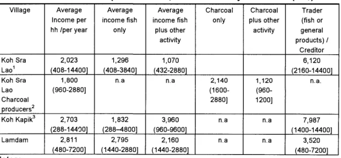
Households were asked to estimate their monthly income. Annual income estimates derived from this information are presented in Table 5.1. The highest incomes were in Lamdam and the lowest incomes in Koh Sra Lao.
Table 5.1. Net Income per Household, Based on Survey Information (US$) Village Average Average Average Charcoal Charcoal Trader
Income per income fish income fish only plus other (fish or hh /per year only plus other activity general
activity products) /
Creditor
Koh Sra 2,023 1,296 1,070 6,120
Lao' (408-14400] (408-3840] (432-2880] (2160-14400]
Koh Sra 1,800 n.a n.a 2,140 1,120 n. a.
Lao (960-2880] (1600- (960-
Charcoal 2880] 1200]
producersz
Koh Kapik3 2,703 1,832 3,960 n.a n.a 7,987
(288-14400] (288-4800] (960-9600] (1400-14400]
Lamdam 2,811 2,795 2,160 n.a n.a 3,520
(480-7200] (1440-2880] (1440-2880] (480-7200] Notes:
1 Other employment in addition to fishing in Koh Sra Lao include: soldier, nurse, lottery ticket seller; charcoal
kiln worker (employed to collect wood or put charcoal into bags).
2 Other employment undertaken by charcoal producers in Koh Sra Lao include: video seller, repair man,
fishing.
3 Other employment in addition to fishing in Koh Kapik include: policeman, seller of general products
Traders/creditors had the highest incomes ranging from US$3,520-7,989. Income
from fishing ranged from US$1,296-2,795 per year, and income from charcoal ranged from
US$1,120-2,140.
Background information pertaining specifically to the three study villages is discussed in succeeding pages.
5.2 Koh Kapik?
The population of Koh Kapik is estimated to be 1,149, consisting of 225 households. The people are mostly ethnic Khmer (with around 10 Thai and Vietnamese families). The nearest markets are Dong Tung (50km away) and Park Klong market (40 km
away).
Only 11 % of households originate from Koh Kong Province. Other households are
from: Kampot (22%); Sihanoukeville (19%); Takeo (14%); Kandal (11%); Phnom Penh
(8%); Kompong Speu (6%); Pursat (3%); Kompong Cham (3%); Siem Reap (3%). Most
migrants (72%) moved to Koh Kapik between 1980-1995 (pre-1980: 8%; post-1995: 6%).
Based on the survey information, the average income per household per year is
US$2,703. Most household (91.5%) depend on fishing as their source of income (80.5% only fish, while 11 % fish, run a small shop, or serve as local policeman). Few (8.5%) are
involved in the trade of either fish or general goods.
Fish is sold to traders in the village (there are reportedly six traders in the village)
and then exported to Thailand. Most fishermen own boats and only a few has to borrow money in order to support their fishing activities.
All interviewees claimed that it was harder to fish now than it was five years ago.
The main reasons for this were: increased number of fishermen from within the village and
outside such as from Thailand (47%); loss of mangrove forest to shrimp farms and
charcoal production (47%); water pollution from shrimp farms (31 %); and, the use of illegal
equipment and fishing methods (e.g. use of dynamite and poisonous substances) and
modern fishing equipment by outsiders (19%).
When questioned about alternative livelihoods to fishing, 64% believed there was
no alternative. Others said that they would: farm in upland (11 %); return to birth village (19%); trade (3%); and collect wood in the upland (3%).
About 25% of the families claimed to have no problems. The main economic problems facing other families (in order of importance) are: poverty, declining fish productivity, food security, illegal check points, loss and lack of fishing equipment, and too many children.
The main environmental problems are considered to be: storms and unstable rain
patterns (72%), deforestation (36%), illegal fishing techniques (19%)8, water pollution of shrimp farms (17%), loss of fish (8%), and others (6%).
Approximately one-third of all the households see themselves as totally dependent
on mangroves, the remaining two-thirds of households consider the mangrove important.
7 Information based on discussions with village chief - Mr Heng Chhoeun and 36 household surveys.
EEPSEA Research Report Series
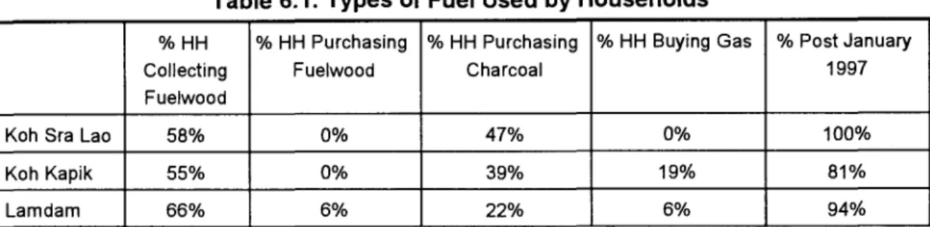
The main products collected from the mangrove area are: fuelwood, snails, and
crabs. The village recognised the importance of the mangrove resource as a habitat for
crab, fish, and local aquatic animals on which they depend for food.
Wildlife in the area includes lizards, leopard, wild pig, deer, pangolin, porcupine, and hornbill. Wildlife is reportedly not collected by the villagers.
Nearly all interviewees (97%) are unhappy about the shrimp farms (3% did not
answer). Construction of a dike apparently restricted the flow of the river from many to one
waterway that is filling with silt and restricting the depth of the river. Complaints have been made to the government, but there has been no response. The main problems with shrimp farms include: water pollution leading to loss of fish (64%); loss of mangroves (11%);
restricted access to fishing area (8%); and, shortage of fresh water (3%). 5.3 Koh Sra Lao9
The population of Koh Sra Lao is estimated to be 1,046 made up of 226
households. The ethnic origin of villagers are Khmer, Thai, and Cham. The nearest local
market is Dong Tong, located 40 km from the village.
Originally the village consisted of only 10 households, but it has grown rapidly as a result of in-migration. Only 3% of households are originally from Koh Kong province. The remaining population has migrated from: Kampot (31%), Kandal (17%), Phnom Penh
(14%), Prey Veng (11%), Sihanoukeville (6%), Takeo (6%), Svay Reing (3%), Banteay
Meancheay (3%), Pursat (3%), Battambang (3%), and Kompong Speu (3%).
For households not involved in charcoal production, 100% of migrants moved to the
area between 1980-1995, with the highest influx (50%) in the 1985-1989 period. For
charcoal producers, migration to the area did not start until 1985. About 50% of charcoal producers moved to the island after 1995. The majority of charcoal producers (60%) were previously farmers in their home village.
The majority of the people in the village are fishermen. At the time of survey, 84%
of households were dependent on fishing for their livelihood (for 66% of households, fishing is their only source of income); 13% were involved in charcoal production and 3%
were buying and selling fish or general products. It is assumed that charcoal producers will
now turn to fishing as their only alternative source of income following the destruction of their kiln, raising the number dependent on fishing to 97%.
In the past, everyone in the village fished. It is claimed that people in the village
turned to charcoal production because of the fall in fish yields (especially in the rainy season). The only alternative to charcoal production in the rainy season is to sell their
labour.
An estimated 98% of fishermen borrow money in order to buy fishing equipment.
The loan is paid off by supplying the creditor with a certain percentage of the fish catch.
Fish is sold to Park Klong market, Mondlesema District, 30km from the village.
A high percentage of households (81%) find it more difficult to fish now than
compared to 5 years ago. The main reasons for this are: more fishermen 50%; loss of mangrove due to shrimp farms 27%; water pollution from shrimp farms 8%; loss of
mangrove due to charcoal production 4%; and, illegal fishing 8%.
A small number of families (between 4-10) have gardens located in the upland area
and grow coconut, banana, cassava, sugarcane, mango, and jackfruit. Cassava is sometimes sold. One household started to cultivate tekke fish in the past year (the viability
of this activity is not known). Illegal logging is evident in the upland areas of Koh Sra Lao.
Hemp is illegally grown by local people in Koh Kong Province financed by Thai
investors. Some women in Koh Sra Lao are occasionally employed to take the leaves off
the plant. Normally 1 kg of fruit can be prepared in a day for which they are paid 25Baht.
This is not a popular job as payment is so low.
An estimated 60% of households do not think there are alternatives to fishing or charcoal production: 12% would farm in the upland area; 12% would return to their home village; 4% would trade; and 4% would collect wood in the upland.
Twelve percent of households claim not to face any economic problems. Main
economic problems faced by other households include: loss/lack of fishing equipment
(62%); poverty/low standard of living (46%); health problems (27%); fall in fish productivity
(8%); food security (8%); and water pollution (4%).
The main environmental problems facing the households are: deforestation (54%);
storms/unstable climate patterns (43%); water pollution from the shrimp ponds (31%);
illegal fishing techniques (15%); harvesting of wild water birds (4%); and, the loss of fish
(4%).
Most households consider themselves totally dependent on the mangrove or claim
that the mangrove is very important to them (94%). The main products collected from mangrove areas are: fuelwood; wood for charcoal; horse and stone crab; and, snails (one
type of snail is collected for food, a second type of snail is sold to shrimp farms as shrimp feed).
Houses are built from products collected from the mangrove areas, or bought from outside depending on the wealth of the household. Medicine is collected from upland
areas, not from the mangrove. Wildlife in upland area includes: tiger, wild pigs, fishing cat
(small tiger), water bird, pigs, monkeys, and snakes. There are monkeys in the mangrove
area, but they are not harvested by the village. The degree of dependence on upland
resources for medicine and food is not clear.
The village understands that activities destroying the mangrove areas will affect their livelihood. They recognised that the mangroves are important for storm protection, as
a source of charcoal and fuelwood, and as a habitat for crab (an important food source). The vast majority of households, 85%, do not support the shrimp farms because the shrimp farms have cleared areas of mangrove forest (while charcoal producers only cut the trees which can then grow back). It is asserted that before the shrimp farms were constructed, the productivity of the mangrove areas was much higher. In particular, effluent discharge is polluting the waters and affecting fish productivity.
5.4 Lamdam10
Lamdam village was established in 1984 and consists of approximately 130