From the Outside
Looking In
The Future of Sydney’s
Rural Land
Background Issues and Workshop
Outcomes
From the Outside Looking In
The Future of Sydney’s Rural Land
Prepared by Ian Sinclair, Andrew Docking, Sheryl Jarecki, Francis Parker and Lynne Saville
Funded by a University of Western Sydney Regional and Community Grant
DOCUMENTATION
The attached paper is an updated version of the previous background issues paper, and now incorporates the outcomes of the workshop held in February. This document now replaces the previous document which was posted on the website.
While most of the document remains the same as the previous background paper, the workshop outcomes have been inserted as Chapters 3 and 4. A list of those invited to the workshop is attached as Appendix II and the “butchers paper” notes have been attached as Appendix III.
The main identifying themes of the Workshop (within chapters 3 and 4) have been extracted for ease of reference.
The participants at the workshop were specialists, experts, practitioners and community members. They represented a wide cross-section of organizations and viewpoints. They were invited to discuss their perspective and views on the future of rural lands. Some participants came from interstate.
Their views are now being presented at a wider public forum, to be held on 21 May 2004.
The workshop consisted of the following themes:
• Session 1: Scanning our world (Context setting session in which all workshop participants shared their perspective on key trends and drivers influencing Sydney’s rural landscape.)
- Present – what present trends and drivers are influencing Sydney’s rural landscapes?
- Future – what future trends and drivers are likely to influence Sydney’s rural landscapes?
• Session 2: More enduring and resilient landscapes for Sydney (Resilient enduring landscapes reflect a co-evolutionary mutually dependent partnership between community and country. Country as a partner that allows community to develop by using its natural resources and ecological services; in return community includes country in its developments to a common future)
- What would Sydney’s rural lands look like as enduring sustainable landscapes?
- What would be the nature of the partnership between community and country that would enable this desired future for Sydney’s rural lands. • Session 3: Capacity stocktake
- What capacities do we, as a society, have to achieve more enduring, sustainable landscapes for Sydney?
- What capacities don’t we have, but must develop?
- What other barriers and constraints much impede progress toward our ideal?
thematic groups to identify potential solutions which would better accommodate their particular sectoral interests within the common desirable future: Integration, Urban Expansion, Sustainability of Agriculture in Sydney, Biodiversity and Environmental Management, Water Quality and Quantity, Lifestyle and Landscape, Social and Cultural Aspects of Farming.)
- Governance issues (statutes, policy, planning, participation) - Knowledge issues (research, education)
- Economic issues (innovative economic approaches)
- Broader social/communication issues (relating to better harnessing a multiplicity of values and understandings around rural landscapes) • Session 5: Specific and collective action and Where to next? (this session
distilled out the solutions generated in Session 4)
- What actions can be taken as a result of this workshop to progress the solutions in the short, medium and longer term.
Chapter 1: Introduction ...1
Chapter 2: Development and Planning Issues ...7
2.1. Introduction ... 7
2.2. Environmental Opportunities and Constraints ... 9
2.2.1. Water Quality and Quantity ...9
2.2.2. Land Degradation... 10
2.2.3. Native Vegetation and Biodiversity ... 11
2.2.4. Landscape Character ... 13
2.2.5. Bushfire Hazard ... 13
2.2.6. Flood Prone Land ... 15
2.2.7. Salinity... 16
2.2.8. Contaminated Land ... 17
2.2.9. Weeds ... 17
2.3. Social and Economic Factors ... 18
2.3.1. Land Use ... 18
2.3.2. Agriculture ... 26
2.3.3. Non-agricultural uses... 33
2.3.4. Ethnicity of Farmers ... 35
2.3.5. Tourism and Recreational activities... 37
2.3.6. Extractive Industry... 38 2.3.7. Urban Growth... 38 2.3.8. Rural Residential... 40 2.3.9. Rural Lifestyle ... 46 2.3.10. Healthy Lifestyles... 47 2.3.11. Villages ... 49
2.3.12. Rural land use conflict ... 49
2.3.13. Emerging Social Issues ... 50
2.3.14. Infrastructure ... 53
Chapter 3: The Workshop ... 55
3.1. Introduction ... 55
3.2. Workshop Participants ... 55
3.3. Workshop Process ... 55
3.3.1. Session 1 – Scanning Our World... 55
3.3.2. Session 2 – Developing More Resilient Enduring Rural Landscapes ... 55
3.3.3. Session 3 Capacity Stocktake ... 56
3.3.4. Session 4 – Thematic Solutions ... 56
3.3.5. Session 5 – Specific And Collective Action... 56
3.4. Workshop Outcomes... 56
Chapter 4: Complementary Complexity ... 58
4.1 Introduction ... 58
4.2 Education ... 58
4.3 Urban Growth Management ... 58
4.4 Social and Cultural Aspects... 59
4.5 Lifestyle... 59
4.6 Security of Farming Tenure ... 60
4.7 Sustainability of Agriculture ... 63
4.8 Natural Environment ... 64
Appendix II – List of Invitees to the Workshop ... 76
Appendix III – Workshop Outcomes... 79
List of Figures
Figure 2.1: The Cycle of Farmland Conversion ...8Figure 2.2: Issues and Themes for Western Sydney Rural Lands...9
Figure 2.3 Land Use ... 19
Figure 2.4: Lot sizes analysis... 22
Figure 2.5: Land Use by Lot Size ... 24
Figure 2.6: Rural Residential Uses ... 25
Figure 2.7: NSW Total Vegetable Production, 1997 ... 27
Figure 2.8: NSW Perishable Production, 1997... 27
Figure 2.9: NSW Nursery, Flowers and Turf Production, 1997 ... 28
Figure 2.10: NSW Poultry Production, 1997 ... 28
Figure 2.11: Agricultural Production for each LGA in the Sydney Region, 1997... 29
List of Maps
Map 2.1: Western Sydney Land Use ... 21Map 2.2: Western Sydney Lot Sizes... 23
List of Photos
Photo 2.1: Wildlife Linkage ... 12Photo 2.2: Wildlife Linkage on private land ... 12
Photo 2.3: Bushfire Destruction in Warragamba ... 15
Photo 2.4: Bushfire Destruction in Glenorie... 15
Photo 2.5: Intensive Agriculture on small lots ... 30
Photo 2.6: Example of non-sustainable agriculture... 31
Photo 2.7: Intensive Plant Growing... 33
Photo 2.8: Service Station and General Store at Maraylya. ... 34
Photo 2.9: Caravan Park along the Hawkesbury River ... 37
Photo 2.10: Extractive Industry at Maroota... 38
Photo 2.11: Rural residential impacts... 42
Photo 2.12: Mix of Rural uses in the Schofield area... 43
Photo 2.13: Housing in the Mixed use area ... 43
Photo 2.14: Rural Residential Housing in Denham Court ... 44
Photo 2.15: Dual Occupancy in Liverpool... 44
Photo 2.16: Rural Residential Truck Use ... 45
Photo 2.17: Rural Residential Horse Use... 46
Photo 2.18: Rural Land Use Conflict at Leppington ... 50
Table 2.1: Number of Primary Land Uses... 19 Table 2.2: Variety of Rural land uses. ... 20 Table 2.3: Distribution of Sydney’s net dwelling-stock increase... 39
Chapter 1: Introduction
Introduction.
The rural land on the fringe of Sydney has competing demands being placed on its use. Rural land has 3 productive components. It is a source of food and fibre, a biodiversity resource and a place for people to live. These relate to the three components of ESD in the following graphic:
Source of Food and Fibre Economic Biodiversity Resource Environment Place to live Social Equity
There is a need to find the balance between all three of these components.
The importance of the rural lands of Sydney has been recognised by the various planning instruments prepared over the years. This is evidenced from the following quote from Denis Winston’s book on the County of Cumberland Plan:
“The County is a small area and not particularly rich from the growing point of view, yet in 1947 it produced three-quarters of the State's lettuces, half the spinach, a third of the cabbages and a quarter of the beans; 70 percent of the State's poultry farms were in the County and more than 18 percent of Sydney's milk came from the County; the preservation of the farms and market gardens is therefore of considerable importance for the well-being of Sydney as well as for the economy of the State.
Rural production in the county has always played an important part in supplying food for Sydney, the advantages of proximity to the largest market in Australia more than compensating for the somewhat poor soil conditions.” (Winston (1957), p49)
The same figures and sentiments are evident today and are acknowledged in the Strategic Plan for Sustainable Agriculture in the Sydney Basin and the current Metropolitan Strategy Shaping Our Cities its companion document for Western Sydney – Shaping Western Sydney. The importance of the rural lands have been addressed in various planning strategies and instruments that have been prepared over the years. However, it is considered that the need for urban growth has taken precedence over the values of the land for its rural values. A recent land use survey conducted for the Department of Infrastructure, Planning and Natural Resources has found that 77.8% of all rural lots are used for rural residential use and that 76.6 % of all lots are less than 3 ha in size. The land is needed to accommodate the expanding population of the Sydney region which is made up of urban and rural residential uses. This pressure to provide living areas is putting a squeeze on the use of the land for agriculture and biodiversity. The land available for these use is becoming scarce as we reach the foothills of the Blue Mountains.
This issue has been the subject of discussion for many years by farmers, planners, Councillors, State Government Agencies and academics. The opportunity of a Community Grant offered by the University of Western Sydney was taken to fund the conducting of a workshop to bring together practitioners working the diverse fields dealing with the rural lands of Sydney to discuss and outline some solutions to this issue. This report has been prepared for a one day forum discussing the outcomes of a 2 day workshop of practitioners designed to draw out issues and pose some
Basin at two levels: overall strategic planning and the implementation of policy at the local government level. The proposed mechanism was to implement a planning approach termed deliberative planning. Deliberative and participative practices include inquiring and learning together in the face of conflict and difference, coming to see issues in new ways leading to action together, practical public action (Forester, 1999). The concept encompasses the use of participatory planning processes and action research where the key ingredients are cycles of planning, implementation and evaluation; linking theory and practice; aiming to bring about change; and democratising the process through addressing issues of power. Reflection and learning of all participants is an essential component.
Deliberative and participative planning practice involves practical public action in messy political circumstances, and the micro politics of practice. It involves how to do planning in a messy politicised world through the plural and conflicting experiences (stories) of differently affected citizens and stakeholders, and the consideration of values.
This process addresses complex, messy issues, through the participation of the community and a wide range of stakeholders, so that the multiplicity of perspectives is included in the debate. The process is multidisciplinary and innovative, encompassing community development, environmental management, and planning. Unlike the one-off consultation process used by many government agencies have used consultation, the process involves community representatives in an ongoing participative process. This process was used because of the obviously complex nature and competing interests in the planning for the future of Sydney. The future of rural lands and agriculture in the Sydney Basin is embedded in planning for urbanisation. The importance of maintaining farming around large cities is being increasingly recognized in Europe, the U.K. and the USA. The spaces described as outer urban, peri urban or the fringe however, pose particular difficulties for planners. Jean & Calenge (1997) noted that these areas are seen by ruralists as creeping urban sprawl, distorting their field of study, and town specialists neglect these areas as a type of extremely undeveloped part of urbanity. Jean & Calenge argue that these spaces cannot be treated in isolation for they form part of a complex spatial system, which results from influences facing the infrastructure, notably economics and from the actions of the inhabitants. “These areas concentrate the states of a vanishing rurality and a spreading urbanity. The spoils are grabbed and formalised by various actors, mainly political, in a very variable and often conflicting manner.” Thus, these spaces are neither urban nor rural. In Sydney, the complexity is further increased by the large numbers of farmers from culturally and linguistically diverse backgrounds who generally operate small family farms, and who have lacked an effective political voice. The initial aim was to achieve a balanced planning approach, in order to secure sustainable agriculture in the fringe of the Sydney Basin.
A research group was established with the following members: Frances Parker, University of Western Sydney
Ian Sinclair, Edge Land Planning David Mason, NSW Agriculture
Peter Herborn, University of Western Sydney Andrew Docking, NSW Agriculture
Michael Druce, Department of Infrastructure, Planning and Natural Resources Lynne Saville, Hawkesbury Food Program, Hawkesbury District Health Service Sheryl Jarecki, University of Western Sydney
The planning group recognised that the future of agriculture in the Sydney Basin was embedded in the broader issue of the future of rural lands in general, not only the future of agriculture, although this is an essential component. Further, it wanted the process to add to the debate, and to “move forward”, and that even if “we don’t have the answer” to such a complex issue then we can at least attempt to develop a mechanism to “produce the answer”. The planning group was unanimous in its desire to produce some positive action, rather than merely “talk about the issues”. Some members of the planning group were of the view that the relevant planning instruments are available, but the implementation, and the political will aren’t.
An important question underpinning this process is “where do we want to be in 25 years time, what sort of city do we want Sydney to be? In general the planning process appears to have considered the needs of urbanisation first, with the future of agriculture, and the rural lands as a residual or "remnant" issue, if it is considered at all. The planning group wanted to highlight the need to consider agriculture and the rural lands in the same way as urban issues are currently considered, so that the planning process is integrated and balanced. This led to the title of the Workshop and the Public Forum- From the Outside Looking in: The future of rural lands in the Sydney Basin.
The broad aims of the workshop held in February, 2004 were to obtain an understanding of how a wide range of other people (stakeholders) see the issues, and to obtain some possible solutions in finding a way forwards through developing alternative scenarios, to identify what knowledge and information is available, and gaps in our knowledge. Experts from a wide range of backgrounds were invited to participate in the workshop, which was facilitated by Mr Peter Davey, former CEO of the Hawkesbury Nepean Catchment Management Trust. It was widely recognised that we needed to engage in and with the political process to bring about change.
A comprehensive background issues paper was prepared and distributed to Workshop participants, and is included in the information developed for the public forum. The workshop consisted of the following themes:
• Integration
• Urban expansion
• Sustainability of Agriculture in Sydney
• Biodiversity and environmental management • Water quality and quantity
• Lifestyle and landscape
• Social and cultural aspects of farming
Although this project has developed the view that the future of agriculture in the Sydney Basin is part of the future of the rural lands, given the value of agriculture and the policy issues surrounding it is important to provide further background information on some relevant initiatives.
Value of Agriculture
The estimated farm gate value of agricultural production in the Sydney Basin is over one billion dollars p.a., and generates over 4.5 billion in economic activity (Gillespie & Mason 2003). This represents 14% of NSW agricultural production. Much of the production is on small family farms. Poultry contributes $1.2 billion p.a. to the Sydney Basin, and cut flowers one billion, which is almost 100% of NSW cut flower production. The Basin produces 40% of the value of NSW vegetable production, and 90% of Sydney’s perishable vegetables. (Gillespie & Mason 2003)
Sustainable Agriculture in the Sydney Basin
In 1998 The Hon Richard Amery, Minister for Agriculture in launching the “Strategic Plan for Sustainable Agriculture-Sydney Region noted “Sydney is under an increasing spotlight both nationally and internationally. Government and non-government institutions are planning for its future. The community consultation process [as presented in the plan] has validated sustainable agriculture and associated lands as credible and worthy components of the mixed pattern of human activity and land use by recognising its potential to contribute a great deal to the socio-economic and environmental sustainability of the Sydney region. This is illustrated by the increasing recognition of these components and their benefits in planning documents such as the Metropolitan Strategy”. Most of the objectives of the Strategic Plan relate directly or indirectly to the need to recognise the importance of agriculture in the planning process, such as in the zoning of land, reducing conflict over land use, the recognition that agricultural land in the Sydney region is a finite resource, and that growth management of residential and industrial land uses in the Sydney region needs to be balanced with the necessity to maintain agriculture, and that the planning profession, state agencies and local government need to recognise the biophysical, social and economic values of agriculture.
In March 2002 participants at the conference “Securing sustainable agriculture in the Sydney Basin” (organised by NSW Agriculture) highlighted that a key issue in securing the sustainability of Agriculture in the Sydney Basin was that of urbanisation and planning. However, there is also a need to provide housing for the increasing population of Sydney. One view is that agriculture can be moved, however, there is a need to recognise the social and economic value of agriculture, and the existing community in the area. Further land release in the Liverpool and Marsden Park areas have been announced recently, both of which are significant agricultural production areas, particularly for vegetables and poultry. This follows the development of the North West sector, specifically Kellyville and Rouse Hill, where productive farms have been subsumed by urbanisation, which in turn has inadequate infrastructure, particularly transport and roads, for the increase in urbanisation. Thus, the issue of balanced planning which is responsive to community development in the fringe encompasses the new residential estates and their location.
Land use planning involves two tiers of government: State Government and Local Government. Local government is of particular relevance for individual farmers, as it is local government’s responsibility to approve development applications.
Another key issue impacting on farming has been the increasing importance of environmental regulations, and water reform policies such as those regulating on farm
dam construction. There is now increasing recognition of the importance of pollution in the South Creek catchment, which covers a third of the Sydney Basin. However, it is not clear to what extent these regulations effectively address environmental concerns, leading to better environmental practice. By way of example, agriculture is perceived as harming the environment, and there are often difficulties in farmers removing trees, and yet there appears to be little conservation of woodlands in the new estates, and individual blocks are too small to sustain large trees. Thus, the environmental effects of urbanisation compared with agriculture appear to have received relatively little attention in the public domain, or in the planning process. Most Councils in the fringe have undertaken rural land use studies. Some Councils have conducted environmental audits of agricultural premises. However, there is little consistency between local government areas, with farms on opposite sides of the road but in different local government areas being treated differently, depending on the regulations, and most importantly, the practice of the specific Council. Furthermore, there appear to be few guidelines and little transparency or consistency in the decision making process in matters such as approval of development applications to build farm buildings, or to farm.
Despite the rural land use studies, and the Strategic Plan for Sustainable Agriculture the implementation process to effectively address agricultural land use and planning is either non existent, and/or lacks transparency, particularly for the industry and individual farmers.
Premier's Task Force into Market gardening by people of non-English speaking Background in the Sydney Basin
A 1995 report by Parker & Bandara focused on the market gardening sector in which 90% of farmers are from culturally and linguistically diverse backgrounds. It highlighted increasing pressure and regulation of the industry and the almost total marginalisation of the sector from government services. This report triggered the formation by the NSW Premier of the cross-sectoral Premier’s Task Force on Market Gardening by People of non-English Speaking Background. One of the terms of reference of the Premier’s Task Force was to “better coordinate land use provisions that recognize the value of market gardening in the New South Wales economy”. However, the final report of the Task Force (NSW Government, 2000) did not address this issue comprehensively. It appeared that the representatives of the then Department of Urban Affairs and Planning considered that the issue would be effectively dealt with by forthcoming regulations.
The Premier's Task Force led to the appointment of a cross-sectoral advisory committee with representatives by NSW Agriculture, NSW Health, the EPA, State and Regional Development, WorkCover, Department of Education and Training, the University of Western Sydney, and the Department of Land and Water Conservation, and various representatives of local government. A project officer was appointed for three years.
Education and Training Plan for Sustainable Agricultrue in the Sydney Basin This initiative of the NSW Department of Agriculture and the NSW Department of Education and Training was in response to the Strategic Plan for Sustainable Agriculture in the Sydney Basin, and the Premier’s Task Force into Market Gardening
that $20 million would be allocated over 5 years to address the education and training needs of the sector. Some, particularly grower representatives, however, note that although access to education and training is of critical importance, the key issue which needs to be addressed as not one of education and training alone, but rather the regulation and planning environment and the urbanisation process, rather than technical production issues alone.
The workshop and the subsequent public forum aim to encourage a full consideration of the issues associated with the development of Sydney, specifically the development of Sydney as a sustainable, healthy city. To assist in the process the accompanying documentation consists of a Background Issues paper, and a summary of the outcomes of the Workshop held in February.
Chapter 2: Development and Planning Issues
2.1. Introduction
The main issues affecting rural fringe areas are the need to preserve the environment, the retention of agriculture and the pressure for subdivision of agricultural areas or the resubdivision of existing rural residential land for more lifestyle living uses. This chapter discusses these issues with the aim of providing a basis for the development of policies for the future.
The increasing trend towards the fragmentation of productive agricultural land is affecting its capability to produce agriculture in a sustainable manner. Once viable farming units are now being made into smaller less viable units and the use changed to residential type uses with no realisation about the impacts of this on such issues as land degradation, rural land use conflict or the cumulative impact of the loss to production of this good agricultural land. This trend is exemplified on the fringe of the Sydney region where the desire for rural living and a productive agricultural hinterland are coming into conflict.
Agriculture on the fringe is becoming more intensive as the value of land increases and hence the need to use it for higher yielding commodities. The intensive agriculture include vegetable growing (in market gardens as well as protected cropping structures such as greenhouses and igloos), nurseries, flowers and turf as well as poultry for meat and eggs. Intensive uses are also being relocated from Council areas that have become urbanised, such as Fairfield, Liverpool and Blacktown to the areas further west.
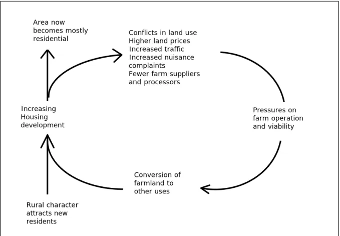
Figure 2.1 shows the “Cycle of Farmland Conversion” which is taken from book on Farmland Preservation in America. It is significant to note that the cycle is as relevant to the Australian situation as it is in America, signifying that it is an international problem.
Growth management strategies can provide a balance between the pressure of urban and rural residential growth and the need protect this high quality agricultural land from further fragmentation and alienation. Sound strategic planning is best placed to provide for the future of agricultural land. In this respect, planning should start with a detailed study of the rural lands in the area which is focused on preserving the agricultural land and rural landscapes and not on looking at land to be converted to rural residential uses, as has often been the case in the past.
Figure 2.1: The Cycle of Farmland Conversion
Source: Daniels and Bower 1997 p 6
There is a perception in the community that rural land is land that is in a holding pattern awaiting subdivision for urban or rural residential development or converted to some other use. This is not correct. Western Sydney has a vibrant and prosperous rural economy with a diverse community. Agriculture in the Western part of the Sydney region is an important commodity and contributor to the regional economy as well as providing a landscape that creates its own unique character.
In order to understand the many issues associated with rural land, it is first necessary to define the terms rural land and rural character. This is a question that has as many answers as there are people who are involved in rural planning. The crudest definition is that rural land is all land that is not urban. However, that is too simplistic for any definition of rural land. Wide open land, farmland, forests, native vegetation, national parks, mountains, rivers, lakeshores, rural villages and rural residential areas all make up the landscape that we describe as rural. It is not any one landform or land use. It is the mixture of them that evokes the term rural land.
Rural Character is a term that is often misunderstood and misused when applied to rural land. The character of a place is the thing that distinguishes rural land from urban land. Rural character is made up of a number of components – the one thing they have in common is the feeling of openness. They include the following: open spaces, agriculture, grazing animals, market gardening, plantations, cropping, sheds, crop protection structures, artificial housing, vegetation (trees, shrubs and grasses) – both native and exotic, houses and outbuildings, varying topography including rolling hills and steep gorges, rivers and streams. (Sinclair, 1999)
Pressures on farm operation and viability Increasing Housing development Conversion of farmland to other uses
Conflicts in land use Higher land prices Increased traffic Increased nuisance complaints
Fewer farm suppliers and processors Area now becomes mostly residential Rural character attracts new residents
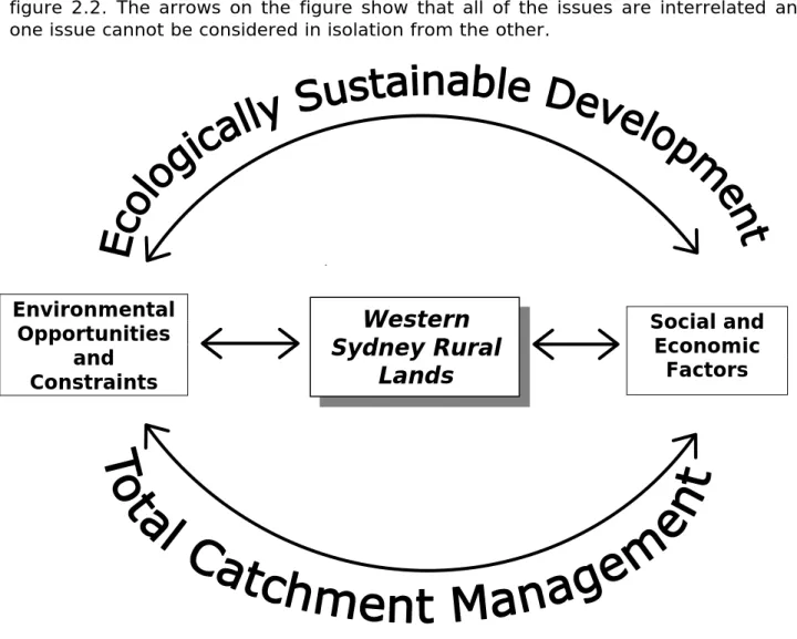
The relevant issues for rural land in Western Sydney can be grouped into 2 broad headings of:
Environmental opportunities and constraints Social and economic factors
Underlying all of the issues is the philosophy of Ecologically Sustainable Development (ESD) and Total Catchment Management (TCM). These issues are shown graphically in figure 2.2. The arrows on the figure show that all of the issues are interrelated and one issue cannot be considered in isolation from the other.
Figure 2.2: Issues and Themes for Western Sydney Rural Lands
Source: Sinclair 2000
2.2. Environmental Opportunities and Constraints
This chapter deals with the environmental issues facing the rural lands of Western Sydney. The sections below discuss the major categories of the environmental issues affecting the rural lands.
2.2.1.
Water Quality and Quantity
The rural lands of Western Sydney all drain into the Hawkesbury River system and the Georges River system. The quality of the water is an issue that has been highlighted
Western
Sydney Rural
Lands
Social and
Economic
Factors
Environmental
Opportunities
and
Constraints
and affects the land in the Camden, Penrith and Hawkesbury areas the most.
Water for stock and domestic use as well as the quality of water leaving the uses within the rural areas are both as important as each other.
Water is used by intensive and extensive agricultural uses, rural residential and extractive industries that are located throughout the rural areas. Of these, the agricultural uses would be the largest users. A great number of these use water that has been extracted from creeks and streams or from groundwater. It is noted that some of these uses also utilise the reticulated water supply provided by Sydney Water. These water users require a licence to extract the water both from the above ground sources as well as the groundwater. There is currently a moratorium on extraction of water from the Hawkesbury river system for new water users. The security of water is therefore an important issue for the future of the rural lands.
Water quality within the rivers has been measured by the EPA The EPA measurements found that the water quality in certain waterways is significantly under stress and impacted by development. It does not meet objectives for ecosystem protection, primary recreation or harvesting fish, particularly during wet weather. The water is generally suitable for stock watering and crop irrigation. The main source of pollutants is run-off from both urban and rural development and may include sewage overflows. It should be noted however, that some of the creeks within the catchment have very good water quality but these are mostly creeks that have very little development in their catchments.
The security of water is a major issue for agriculture and other rural pursuits. The Department of Infrastructure, Planning and Natural Resources have placed a moratorium on extraction of water from the river because of the water quality problems and the fact that they did not have any way to control the amount of water that was being extracted. This is a contributor to the current problems being faced by the river and was highlighted as a concern by the Healthy Rivers Commission. The Farm dams policy has implications for the continuation of agriculture in the region because of the limitations on the amount of water that can be harvested for irrigation of crops.
2.2.2. Land
Degradation
Land degradation is related to the water quality. The Western Sydney Regional State of the Environment Report has identified land degradation as a key issue. It states that the current activities that may result in land degradation are primarily those leading to dryland salinity, erosion and land contamination.
Contaminated sites are a result of past land management practices and land uses that leave sites contaminated with agricultural chemicals, residues of industrial chemicals and unknown impacts from old landfill sites.
Soil erosion occurs when soil is disturbed as a result of the land development process. This leaves soil bare and exposed to rainfall and run-off. The slope of the land will lead to an increase in the amount of soil erosion, "The impacts of soil erosion are mostly felt away from the site where the erosion has occurred and causes sediment buildup and high turbidity in streams. In the case of agricultural soils, the erosion is
also an issue when scarce fertile soils are lost. Eroded sites are also susceptible to weed invasion." (WSROC 2000 p63)
Soil erosion and sedimentation is an issue, which intensifies, as the uses become more intensive. Of particular note is the intensive plant growing using soil based agriculture such as market gardening, which becomes problematic when the lots get smaller. It has been noted a high proportion of intensive plants are on lots of 2 ha, and on these lots, it is difficult to contain the soil and nutrients, as well as having enough land to grow the crop. It also becomes an issue for the more steeply sloping land and the construction of dwellings particularly rural residential uses which tend to be on smaller lot sizes.
It is therefore evident that agricultural uses contribute to land degradation and there is a need to ensure that it is properly managed. It should be pointed out that urban and rural residential uses also contribute to land degradation.
Soil erosion becomes more of a problem with the dispersive clay soils. The clays stay in suspension in the water for longer periods and cannot be trapped by conventional sediment controls.
Most Councils have Sediment and Erosion Control DCPs that refers to this issue. It requires the proponent to erect appropriate sediment control devices to ensure that the sediment does not leave the site. The effectiveness of this DCP has not been tested and the development of indictors of sustainability will help to do this.
2.2.3.
Native Vegetation and Biodiversity
"The significance of biological diversity is often expressed in terms of the 'ecosystem services' provided by plants and animals; that is, the role of biological diversity in maintaining the physical environment and food chain on which humans depend. That the functioning biological systems are essential to maintain water quality, the cycling of nutrients, the quality of the atmosphere and formation of soils. Also the cultural spiritual and economic days are by diversity are being increasingly recognised."(WSROC 2000 p115)
The status of biodiversity is different in the sandstone ecosystems in the north, west and south from the shale ecosystems associated with the Cumberland plain in the east of the region. The Western Sydney Regional State of the Environment Report states that there are 220 plant species and over 80% of the pre-European vegetation cover in the sandstone areas. In this area approximately 90% of the known communities are considered to be adequately conserved. In contrast to this, the Cumberland plain supports only 26% of the pre-European vegetation cover. Currently 9 of the 18 Cumberland plain vegetation communities are considered to be endangered. (WSROC, 2000, p113)
At a regional level, 51 plants and 52 animals are listed as rare to threatened. (WSROC, 2000, P113). The sandstone areas, because of the larger species diversity have the bulk of these species.
Habitat linkages are an important part of the biodiversity of the region. They provide for the movement of animals from one are of biodiversity to another. Habitat linkages are often bisected by roads and also are located on private land. Photo 2.1 shows a
2.2 shows habitat linkages over private land in Llandilo in Penrith City.
Photo 2.1: Wildlife Linkage
Date of Photo: June 2001
Photo 2.2: Wildlife Linkage on private land
Date of Photo: December 1999
The clearing of land is an issue more for the clearing of understorey plants than wholesale clearing of trees. Property owners often wish to ‘clear the scrub’ to avoid bushfires or just to make their properties look better. However, this can have just as much, and in some cases, a more dramatic impact on biodiversity than the clearing of large trees because of the habitat that it provides.
The National Parks and Wildlife Service has prepared a study and series of maps into the native vegetation of the Cumberland Plain Western Sydney.
Rural residential uses are considered to have a major impact on biodiversity, especially in those areas which have a high number of smaller lots with large areas of habitat, like Londonderry in Penrith City and Annangrove, Kenthurst and Glenorie in Baulkham Hills
2.2.4. Landscape
Character
The predominant rural character of the Western Sydney rural lands is created by the numerous rural activities, large lot sizes, vegetation and ridgeline roads. The rural lands provide constant variety in landform and landuse from north to south and east to west. Changes to landuse generally arise from topography, which is evident through the high proportion of rural activities contained on ridges and plateaus with the majority of bushland being contained to steep valleys.
The individual localities within the rural lands each evoke a rural atmosphere. Areas like Camden, Luddenham, Maraylya and Wilberforce are easily identifiable as rural given the cleared pasturelands, fencing and rural activities evident from the major roads. River Interface areas particularly in the north of the area such as Portland and Sackville are less obvious as being rural. Their agricultural activities are on a smaller scale being mostly contained to orchards on the river flat areas with the majority of the locality being dense bushland.
The rural character is fully appreciated when compared to the intense residential development in areas like Rouse Hill - Kellyville, Glenmore Park and Cecil Hills which has formed a hard edge to the rural lands. The visual contrast is significant as there is no transition between the two landuses. Transitional areas may include vegetated buffer zones and should be considered as a means of enhancing the landscape character.
The retention of roadside vegetation is an issue which may require future negotiations with service providers. Other controls which may be considered for retaining the rural character include:
Planting controls for screening undesirable elements and incorporating buffers to significant environmental communities,
Building controls for siting and advertising,
Planning controls for lot sizes, the design and siting of residential dwellings and ancillary buildings, in relation to the visual amenity of road corridors.
It is important to recognise the visual amenity of open paddocks, dense creekline vegetation, unimpeded distant views to the Blue Mountains and the broad expanse of the Hawkesbury River as a visual resource. The rural lands of Western Sydney are one of the few areas close to Sydney where there is opportunity for experiencing such a unique environment.
2.2.5. Bushfire
Hazard
The large number of rural residential properties as well as the vast areas of native vegetation and the various topographic landforms combine to create a bushfire risk
Bushfire Risk Management Plans. It uses a strategic approach in the application of management policies, procedures and practices for dealing with bushfire risks. Its main aim is to deal with the hazards before they have an adverse effect upon the community values as well as preparing a community for the possibility of the bushfires.
The protection of the identified community assets is a key issue as is the preservation of biodiversity within the rural lands.
Managing the bushfire risk is noted as the key factor in dealing with the bushfire hazard. One of the management options is risk avoidance and therefore, land that is prone to bushfires should not be rezoned and subdivided where an adequate fire protection zone cannot be established. This is especially so for land that is on the sides of the many gullies that run in a general east-west direction.
The bushfire season commences in late spring and usually is finished by autumn. A dangerous bushfire season is most commonly associated with two or more of the following factors in combination:
Occurrence of an extended drought period; Lower than average rainfall through winter;
Persistent north to north westerly winds in late spring and through summer; Prolific grassland fuel occurrences from strong growing season the previous summer; and
High ignition potential during school holiday period.
The major sources of ignition of bushfires within the Shire are escapes from burning off, power line cables, arson, car dumping and lightning.
Hazard reduction burning is usually carried out in the autumn and winter months and is in accordance with the Bushfire Management Committee's Annual Fuel Reduction Program.
Photos 2.3 and 2.4 show the devastating effect of bushfires. Photo 2.3 shows the remains of a house in Warragamba in the December 2001 bushfires and photo 2.4 shows the remains of a semi-trailer parked beside Old Northern Road at Glenorie in the December 2002 bushfires.
Photo 2.3: Bushfire Destruction in Warragamba
Date of Photo: December 2001
Photo 2.4: Bushfire Destruction in Glenorie
Date of Photo: December 2002
2.2.6.
Flood Prone Land
The major flooding in occurs on the Hawkesbury and Nepean Rivers. It affects different areas in different ways. Areas like Hawkesbury, Camden and Penrith LGAs are more affected because of the low lying land and intense settlement patterns. Other areas like Baulkham Hills are not as affected because of the sparse amount of settlement along the river which only affects a small number of houses and commercial caravan parks. The State Government is preparing a Flood Study and has completed flood mapping. The major impact on the future of the are is one of isolation in times of flood because of access roads being inundated.
and drainage lines. It is of particular impact where roads cross these creeks and they can be inundated and closed for periods of time. This can cause short term isolation. Most Councils have established a Floodplain Management Committees to prepare a floodplain management plan under the provisions of the new floodplain management manual. This will ensure that the Council has considered the issues of flooding including the probable maximum flood in all future planning for the rural lands. This is particularly important for those uses along the Hawkesbury River and particularly the tourist uses that may wish to expand their operations.
2.2.7. Salinity
Salinity can be a symptom of environmental change resulting from natural processes as well as human impacts. It can also exist without any interference. In western Sydney it is an existing process that is exacerbated by human activity, particularly European farming techniques, land clearing and urban development. It is the result of past and present land management practices, which have dramatically changed the way water is cycled through the environment. The salinity in Western Sydney does not occur on the sandstone areas.
A detailed Salinity Hazard Mapping project has been undertaken by the Department of Land and Water Conservation and it was released in draft form in December 2000. The map that accompanies the document shows that salinity is present and has the potential to occur in all of the creek lines, particularly South Creek. A study was carried out on salinity in the South Creek Valley and published by the Department of Land and Water Conservation in August 1997. This study highlighted the issue in the south creek catchment. Its main recommendation was to make good planning decisions to minimise or eliminate the impact of rising watertable and salinity. There is a need to adopt a catchment approach to the issue.
“There are a number of simple actions which everyone can take to help reduce the impact of salinity. These include retaining existing tree cover and prevention of over watering parks and gardens. Other recommendations include growing native plants and mulching gardens.
The State Government has recently released the NSW Salinity Strategy which is aimed at reducing the land affected by salinity over the next 10 years. The Strategy highlights the following things that can be done to slow down salinity:
Protect and manage native vegetation;
Use land so less water goes into the watertable; Use water more effectively and efficiently; Make better use of land affected by salt; and
Focus efforts on priority salinity hazard landscapes.
The basic message to be learnt about salinity is not to unnecessarily clear vegetation or change drainage patterns which is one of the major causes of a rising water table that, in turn causes salinity. Other issues to consider include the overgrazing of stock, land degradation and development on sloping land.
2.2.8. Contaminated
Land
This issue is related to the previous use of land. It is an issue because of a lack of understanding of the issue in the past. It is important to recognise in rural areas because of the potential health risks to future residents of the land, especially that land which is to be used for rural residential rather than continue as purely rural.
The State Government has recently released a State Environmental Planning Policy (SEPP 55) which sets a procedure to be followed for both development and rezoning issues.
Councils have guidelines on contaminated land that explains the issue. The guidelines have been prepared to outline the objectives, standards and procedures for the assessment and remediation of contaminated land and land suspected of being contaminated due to the past land uses or land fill. The guidelines are based on “Managing Land Contamination – Planning Guidelines” prepared by DUAP and NSW EPA.
2.2.9. Weeds
Weeds are one of the most serious threats to Australia's natural environment and primary production. They can destroy the native species, contribute significantly to land degradation and reduce farm and forest productivity. The National Weeds Strategy has identified the problem and states that the cost of weeds to Australia is approximately $3.3 billion per annum. The New South Wales weeds strategy estimates the value of control and lost production at $600 million per annum. Both the National and State strategies identify funding, education and better coordination of control programs as being important.
A weed can be described as an unwanted plant. It has been estimated that 17 % of Australia’s flora consists of exotic weeds. In fact, of the 200 plants that have been declared noxious nationwide, nearly half were introduced as ornamentals or for other reasons. They have an impact on primary production as well as invading bushland and waterways. The problem is getting worse, not better, as settlement of the land has created favourable conditions for them to spread.
Weeds are becoming a problem to the community at large as they invade the urban and rural environment and the bushland. This is due in part to the expansion of urban areas as well as the increasing amount of rural residential uses and hobby farms with absentee landlords. These create favourable conditions for the weeds to prosper. There is an increase in the nutrient levels with on-site effluent disposal and the location of development (both urban and rural residential) near to bushland causing weed invasion. This weed invasion occurs through the nutrients killing the vegetation as well as “garden escapes” where weeds overgrow into the bushland. Weeds can also grow on the exposed earth as the subdivision is being developed.
Weeds are voracious. They can be water or land based - some can be both! Water based weeds especially can be a major problem. Two such examples are Alligator Weed and Salvinia. Both are introduced species and most people know Salvinia as the plant that is in a lot of fish tanks. Both Alligator Weed and Salvinia can grow to such a thickness that it can be walked on! When it covers the entire waterbody it kills all other plant and animal life.
good example is Kikuyu, which is a grass on many backyards. It thrives in nutrient rich situations such as at the end of a septic irrigation area. It is also one of the most common “weed invasions” into bushland.
There are outbreaks of weeds all throughout the rural lands of Western Sydney. They occur in drainage channels and creeks as well as in areas of native vegetation.
There is a need therefore to consider the preparation of Weed Management Plans for developments that have the potential to cause the spread of weeds by clearing large tracts of land or that generate effluent in sufficient quantities that may kill native vegetation which then allows for the weeds to invade the bushland.
2.3. Social and Economic Factors
2.3.1. Land
Use
There are a variety of land uses within Western Sydney. They include urban, agricultural, native vegetation, rural residential, extractive industries, commercial and light industrial uses. They all have an impact on each other as well as the environment. Finding the balance between these often-competing desires is the key to planning for rural land uses.
Land use in other Council areas are also important and there is a need to consider the uses as well as the controls on land use adjoining the area when making an assessment of future development options. This is particularly important if the adjoining LGA has a large minimum lot size and a smaller one is being considered. It is also important for the establishment of biodiversity linkages.
A recently completed project for the Western Sydney Regional Office of the Department of Infrastructure, Planning and Natural Resources by EDGE Land Planning has been a comprehensive land use survey of all rural land in the following 9 Council areas: Baulkham Hills, Hawkesbury, Blacktown, Fairfield, Penrith, Blue Mountains, Liverpool, Camden and Campbelltown. The study was limited to these areas because this is the area administered by that office of the Department. However it is representative of the other 4 Council areas of Gosford, Wyong, Hornsby and Wollondilly and it is considered that the land use patterns would be similar for these areas.
Land Use
The land uses within the study area are diverse. They can be classified into 9 broad categories (which are defined in Appendix 1) as follows:
Rural Residential Intensive Plants Intensive Animals Extensive Agriculture Vacant Cleared Native Vegetation Extractive Industries Public Use Village
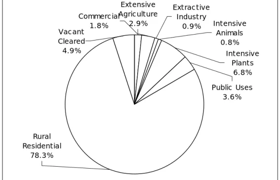
There are a total of 42,377 lots within the rural lands that were counted in the landuse survey. This included the village areas of within each Council area. However, for the purpose of the following discussion, the village areas have been excluded, as
they are not considered to be rural land per se and the inclusion of them skews the percentages of the land uses because there are so many of them. Also excluded are the areas of native vegetation. These have not been counted because of the large number of lots of varying size as well as the land that is in the National Parks and Nature Reserves. When these are taken out there are a total of 32,807 lots in the study area.
The overall landuse for the area is shown in Figure 2.3 and Table 2.1 below. Map 2.1 shows the spatial representation of the land use. It can be seen that the largest landuse (in terms of the number of lots) is rural residential with 78.3 percent of all rural lots having a residential use as the major use of the property. Intensive Plant uses are the next most dominant with 6.8 percent. Land that is vacant is 4.9% and this is the third highest. Then it is Public Uses, Extensive Agriculture, Commercial, Intensive Animal uses and extractive industries.
Extensive Agriculture 2.9% Extractive Industry 0.9% Commercial 1.8% Vacant Cleared 4.9% Intensive Animals 0.8% Intensive Plants 6.8% Public Uses 3.6% Rural Residential 78.3%
Figure 2.3 Land Use
Table 2.1: Number of Primary Land Uses
Land Use Number
of Uses Percentage of Total Rural Residential 25,676 78.3 Intensive Plants 2,226 6.8 Vacant 1,620 4.9 Public Uses 1,195 3.6 Extensive Agriculture 944 2.9 Commercial 575 1.8 Extractive Industry 295 0.9 Intensive Animals 276 0.8 T O T A L 32,907 100.0
categorised in to agricultural uses, non-agricultural uses and rural residential uses. Table 2.2 lists the variety of uses observed in the rural areas.
Table 2.2: Variety of Rural land uses.
Agricultural Uses Non-agricultural uses Rural Residential Uses
Market gardening Orchards
Poultry for meat Poultry for eggs Nurseries Hydroponic Lettuces Irrigated cropping Mushrooms Dairying Cattle Horse studs Alpacas Deer Aquaculture Turf Farming Service Stations Hardware Stores Caravan Parks
Farm Produce stores Research Establishments Manufacturing
Warehouses
Churches and Schools Cemeteries
Light industrial uses Auto electrician Car Wreckers Tourist facilities Veterinary Surgeons Retirement Villages Dwellings Dog kennels Truck activities Earth moving contractors Horses Home based businesses
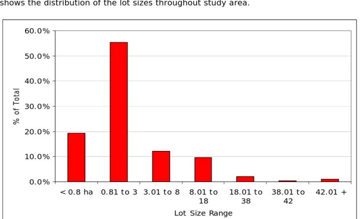
Lot Size
An analysis of the lot sizes has been carried out. This was done to provide an indication of the fragmentation of the land and to provide a picture of areas where there was a dominance of small lots.
The lot sizes ranges for each individual Council area are provided within Appendix 2. The lots counted do not include village or native vegetation because they would not provide a proper representation of the total lot distribution of privately held rural land. The total lot size analysis for the study area is provided below in figure 2.4. Map 2.2 shows the distribution of the lot sizes throughout study area.
0.0% 10.0% 20.0% 30.0% 40.0% 50.0% 60.0% < 0.8 ha 0.81 to 3 3.01 to 8 8.01 to 18 18.01 to 38 38.01 to 42 42.01 + Lot Size Range
% of
T
ot
al
Figure 2.4: Lot sizes analysis
From these it can be seen that there is a dominance of lots in the 0.81 to 3 hectare range being mostly around the 2 hectare size. There is also a large number of lots less than 0.8 ha, most of which are in the 4,000 m2 category. Therefore the total
percentage of lots less than 3 ha is 76.6%. It is significant to note that there are very few lots greater than 8 ha (13.2%).
It is also significant to note that the smaller lots are located adjacent to the urban areas, which can act as a constraint to the future development of the land due to this fragmentation.
The predominance of lots in the 0.8 to 3.0 ha range is common in all Council areas. Some, like Blue Mountains, Camden, Hawkesbury and Penrith have approximately 20 to 30% of the lots in the less than 0.8 range with the rest having between 10 and 15 % of lots less than 0.8 ha in size. Hawkesbury and the Blue Mountains have the highest percentage of lots in the ranges greater than 3ha.
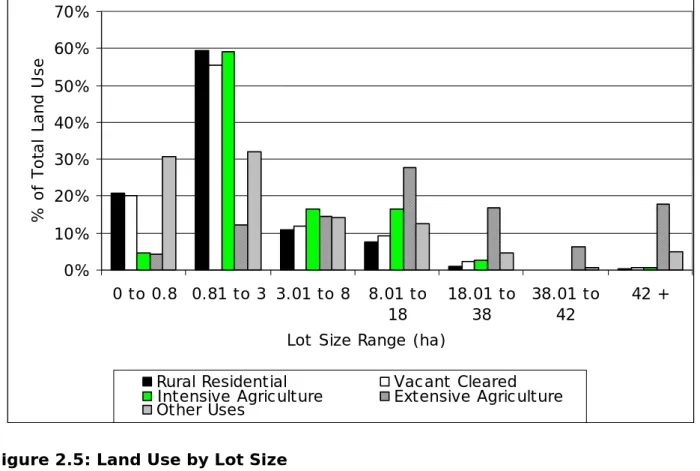
Land Use by Lot Size
The land use data has been cross referenced with the lot sizes to show the proportion of land use that is within each lot size range. Figure 2.5 shows the results of this analysis. The major land use categories of rural residential, intensive agriculture (combining intensive animals and plants), extensive agriculture and vacant land have been shown and the others have been grouped together (extractive industry, commercial, and public uses).
Figure 2.3 shows that, as expected, in the lot sizes below 8 ha the highest proportion of uses is rural residential. There is also the majority of intensive agriculture on lots of 0.8 to 3 ha. It should also be noted that there are a number of rural residential uses on lots of 8 ha and above, which is approximately 10% or 3,000 odd lots. These are also scattered between productive agricultural uses which can lead to some instances of rural land use conflict. It is also an indicator of the desire for rural lifestyle living, which is discussed, in the next chapter.
This graph serves to verify the trend of increasing rural residential uses, particularly on larger lots that have been used for agriculture in the past. It also signals the decline in agricultural uses on the fringe of Sydney. However, it also must be noted that there are some agricultural uses that are starting up in the region.
0% 10% 20% 30% 40% 50% 60% 70% 0 to 0.8 0.81 to 3 3.01 to 8 8.01 to 18 18.01 to 38 38.01 to 42 42 + Lot Size Range (ha)
% o f T o ta l L a n d Us e
Rural Residential Vacant Cleared Intensive Agriculture Extensive Agriculture Other Uses
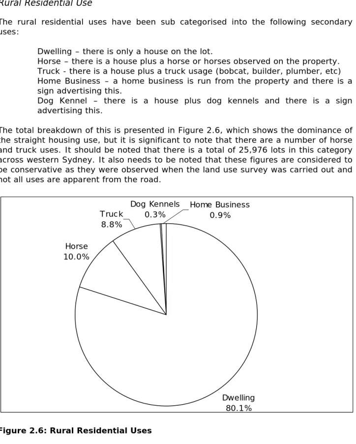
Rural Residential Use
The rural residential uses have been sub categorised into the following secondary uses:
Dwelling – there is only a house on the lot.
Horse – there is a house plus a horse or horses observed on the property. Truck - there is a house plus a truck usage (bobcat, builder, plumber, etc) Home Business – a home business is run from the property and there is a sign advertising this.
Dog Kennel – there is a house plus dog kennels and there is a sign advertising this.
The total breakdown of this is presented in Figure 2.6, which shows the dominance of the straight housing use, but it is significant to note that there are a number of horse and truck uses. It should be noted that there is a total of 25,976 lots in this category across western Sydney. It also needs to be noted that these figures are considered to be conservative as they were observed when the land use survey was carried out and not all uses are apparent from the road.
Dwelling 80.1% Horse 10.0% Dog Kennels 0.3% Truck 8.8% Home Business 0.9%
2.3.2. Agriculture
The protection of high quality agricultural land within the Sydney region is an issue paramount to the future planning of the region if it is to continue to grow its own fresh food and produce. Agricultural production in the Sydney region is an important part of the economy as well as providing a rural hinterland. It is the LGAs located on the fringe of Sydney which produce a significant proportion of the fresh produce both consumed and produced in New South Wales (especially perishable commodities). The main agricultural produce grown in Sydney's urban fringe is perishable vegetables, poultry, nurseries, flowers and cultivated turf. There are also considerable dairies, orchards, horse studs and spelling properties as well as goats, deer, alpacas and other traditional forms of agriculture.
NSW Agriculture has valued agriculture in the Sydney region as being worth approximately $1 billion (Gillespie and Mason, 2003). (This figure did not include the horse bloodstock industry which can be conservatively valued at a further $1 billion).This represents 12% of the total value for NSW and it is grown on 1% of the land. (Gillespie and Mason, 2003). However, this figure for the total value is a conservative figure. In a recent study by the University of Western Sydney Hawkesbury titled the “Impact of Rural Subdivision on Agriculture”, detailed analysis was carried out of the value of production for Wollondilly and Hawkesbury Council areas. This found that the value for Hawkesbury was $211 million and Wollondilly $360 million. As these are only 2 of the agricultural producing Council areas in Sydney it can be said that the figure of $1 billion is an underestimation. NSW Agriculture have also outlined that there is 77,000 ha of land in the region that is devoted to agriculture farmed by 2,000 farmers. The average size of farms is 40 ha compared to 1,454 for the State. Using 1997 ABS Agriculture Census values of production, the average return per ha for farmers in Sydney is $5,433 compared to $136 per ha for NSW. (NSW Agriculture 2003, p1).
Analysis has been carried out of the Australian Bureau of Statistics Agricultural Census to give an indication of the relative value of agriculture in the Sydney region compared to other regions of New South Wales. This research has shown the dominance of the Sydney region for intensive agricultural commodities such as perishable vegetables, poultry, nurseries, flowers and turf. This information has been graphed to show the relative differences between the regions and highlights the importance of Sydney.
Vegetable production occurs in all regions of NSW. The Murray and Murrumbidgee regions produce the highest percentages of total vegetable production (24% and 31%) respectively. The Sydney region contributes 20% of the total vegetable tonnage produced in NSW. (See Figure 2.7) However, when one breaks vegetable production rates into perishable commodities, (those commodities that perish quickly when harvested and therefore need to be located close to the market they serve) a different picture emerges. It can be seen from figure 2.8 that the Sydney region produces 100% of the State's Chinese cabbages and sprouts, 80% of fresh mushrooms, 91% of spring onions and shallots. The Sydney region also accounts for 40% of the State's total area devoted to nurseries, 55% of flower production and 64% of the total area under cultivated turf (See Figure 2.9). Poultry production in the Sydney region accounts for 48% of the State total. Figure 2.10 illustrates this and shows that the Sydney region is where the most of the various types of poultry products originate (these being chickens, ducks and turkeys for meat as well as egg production).
Agriculture occurs in all of the fringe Council areas of Sydney. Their contribution to selective commodities is shown in Figure 2.11.
Figure 2.7: NSW Total Vegetable Production, 1997 Source: Sinclair, 2003 0.0% 20.0% 40.0% 60.0% 80.0% 100.0% 120.0% Sydn ey Hunt er Illaw arra Rich mon d-Tw eed Mi d-North Coa st North ern North Wes tern Cent ral W est Sout h Ea ster n Murr umbi dgee Murray Far W est Region Pe rc en ta be fo T ot al
Sprouts C hinese C abbages Spring Onions & Shallots Fresh Mushrooms
Figure 2.8: NSW Perishable Production, 1997 Source: Sinclair, 2003 0.00% 5.00% 10.00% 15.00% 20.00% 25.00% 30.00% 35.00% Syd ney Hun ter Illawarra Richmo nd-T wee d Mid-N orth C oast Northe rn North W este rn Centr al W est South E aster n Murr umbi dge e Murray Far Wes t Region % of Total
Figure 2.9: NSW Nursery, Flowers and Turf Production, 1997 Source: Sinclair, 2003 0.0% 20.0% 40.0% 60.0% 80.0% 100.0% 120.0% Sydn ey Hunt er Illaw arra Rich mon d-Tw eed Mi d-North Coa st North ern North Wes tern Cent ral W est Sout h Ea stern Murru mbidg ee Murra y Far W est R e g i o n % o f T ot al
C hickens Ducks Turkeys Other Poultry Eggs
Figure 2.10: NSW Poultry Production, 1997
Source: Sinclair, 2003 0.0% 10.0% 20.0% 30.0% 40.0% 50.0% 60.0% 70.0% Sydn ey Hunt er Illaw arra Rich mond -Twee d Mi d-North Coa st Nort hern Nort h W ester n Cent ral W est Sou th E aste rn Murru mbi dge e Murra y Far We st Per ce n tag e of T o ta l
0.0%
10.0%
20.0%
30.0%
40.0%
50.0%
60.0%
70.0%
80.0%
Ba
nk
st
ow
n
Ba
ul
kh
am
H
ills
Bl
ac
kt
ow
n
Bl
ue
M
ou
nt
ain
s
Ca
m
de
n
Ca
m
pb
ell
to
wn
Fa
irf
iel
d
Go
sf
or
d
Ha
wk
es
bu
ry
Ho
rn
sb
y
Liv
er
po
ol
Pe
nr
ith
W
ar
rin
ga
h
W
oll
on
di
lly
W
yo
ng
%o
f T
o
ta
l
Vegetables Fruit & Nuts Total Poultry Eggs Turf Nurseries Cut Flow ers
Figure 2.11: Agricultural Production for each LGA in the Sydney Region, 1997
Agriculture on the fringe is becoming more intensive as the value of land increases and hence the need to use it for higher yielding commodities. Intensive uses are also being relocated from other Council areas that have become urbanised. Anecdotal evidence is that a number of the farmers carrying out intensive forms of agriculture in the Councils in Western Sydney have relocated from farms in the Fairfield, Liverpool and Blacktown areas that have been urbanised over the past 10 to 20 years.
As shown in the land use by lot size analysis in chapter 2, most of the intensive agriculture is practiced on lots in the 0.8 to 3 ha range, which is considered to be unstainable because of the potential to create rural land use conflict and lack to area to adequately deal with soil and water management on the property. This can be seen in photo 2.5.
Photo 2.5: Intensive Agriculture on small lots
Date of Photo: April 1999
The urbanisation of Sydney’s agricultural lands, especially those used for intensive plant growing has to be considered in the wider context of Sydney’s food supply. In Blacktown, for example, there is a total of approximately 400 ha of intensive plant uses and in Liverpool, there is approximately 700 ha of intensive plant uses. It is noted that both of these areas are being investigated for potential urbanisation (North West Sector and Bringelly Urban Investigation Areas) and the relocation of this agricultural use should be considered. It is possible that the loss of the number of uses could have an impact on the supply of fresh food into the Sydney markets as the Sydney region produces the greatest amount of perishable produce in the State as noted above.
For agriculture to remain on the fringe of Sydney, it must become sustainable. Sustainability in this context embraces the concept of Ecologically Sustainable Development or ESD.
Sustainable agriculture, from a land use planning point of view, must embrace environment, economics and social concepts (ESD). A definition of sustainable agriculture therefore is as follows:
“use of land … which can be maintained and managed so that the land remains
environmentally sustainable (that is, environmental pollution and land degradation arising from the use is minimised);
socially sustainable (that is, land use conflict and loss of amenity of the surrounding area arising from the use is minimised); and
economically sustainable (that is, there is a capability of making a net farm profit from the use” (Sinclair, 1999)
A use may be economically sustainable, that is it makes a living for the farmer, but it may be on a lot that is not large enough to allow it to manage the nutrients or odour and may have an impact on the amenity of the neighbourhood. It is therefore unlikely to be sustainable. Unsustainable practices include market gardening on small lots, hydroponics on small lots, overgrazing of land by cattle and the loss of topsoil through erosion. Photo 2.6 shows a good example of this from Llandilo in the Penrith Council area. The three separate market gardens in the middle foreground are planted from boundary to boundary with no buffer strips and there is also no buffer between the creeks. There is no way to manage the soil and water on the three farms.
Photo 2.6: Example of non-sustainable agriculture
Date of Photo: December 1999
Agricultural land uses on the fringe of metropolitan areas are becoming more intensive. The fringe of the metropolitan areas is also where a large amount of the population growth of Sydney is occurring. This is a similar situation in United States of America where considerable research has been carried out and literature written on the subject. The issues facing fringe metropolitan areas in United States are similar to those facing the fringe of Sydney. Daniels and Bower in their 1997 book titled Holding our Ground - Protecting America's Farms and Farmland make the