International bottom trawl survey in the Mediterranean
Instruction manual
The MEDITS programme is conducted within the
Data Collection Framework (DCF) in compliance
with the Regulations of the European Council n.
199/2008, the European Commission Regulation n.
665/2008 the Commission Decisions n. 949/2008
and n. 93/2010. The financial support is from the
European Commission (DG MARE) and Member
States.
This document does not necessarily reflect the views of the European Commission as well as of
the involved Member States of the European Union. In no way it anticipates any future opinion
of these bodies. Permission to copy, or reproduce the contents of this report is granted subject
to citation of the source of this material.
Preamble
The MEDITS project started in 1994 within the cooperation between several research Institutes
from the four Mediterranean member States of the European Union. The target was to conduct a
common bottom trawl survey in the Mediterranean in which all the participants use the same
gear, the same sampling protocol and the same methodology.
A first manual with the major specifications was prepared at the start of the project. The manual
was revised in 1995, following the 1994 survey, taking into account the methodological
improvements acquired during the first survey. During the course of years, several
improvements were made. A new version of the manual was issued each time it was felt
necessary to make improvements to the previous protocol. In any case, each time the MEDITS
co-ordination committee ensured that amendments did not disrupt the consistency of the series.
The third version of this manual was edited in 1999, while the fourth one served as a manual for
the surveys carried out between 2000 and 2006. The fifth version, although issued in 2007,
included improvements adopted by the MEDITS group since 2005, and was the protocol
followed from the 2005 surveys until 2011 due to the issue of the present version.
This sixth version is an update of the 2007 MEDITS handbook, taking into consideration the
evolution of the MEDITS survey within the Data Collection Framework. This version presents
changes related to the reference list of species, the biological parameters to be collected, and
consequently the storage data formats that have been adjusted to account for these changes.
Co-ordination of the MEDITS program (2012)
Co-ordination
The MEDITS program is currently co-ordinated at international level by Maria Teresa
Spedicato (COISPA Tecnologia&Ricerca, Italy).
The MEDITS group is currently composed as in table 1. The members of the Steering
Committee are indicated by the letter N in the same table.
Table 1 List of National MEDITS coordinators and regional coordinators
GSA Country Scientist
Name
Affiliation Address/Telephone Email address
Spain Enric Massutí
N I.E.O. Instituto Español de Oceanografía, Spain
IEO- Centro Oceanográfico de Baleares P.O. Box 291 07080 Palma
Phone: (34) 971401877 Fax: (34) 971404945
1,2 Spain Luis Gil de Sola R I.E.O., Centro Oceanográfico de Málaga Muelle Pesquero s/n; 29640 Fuengirola, Tel. +34 952472261 Fax: +34 952463808 [email protected] 5 Spain Antoni Quetglas R I.E.O. - Centro Oceanográfico de Baleares;
P.O. Box 291 07080 Palma Phone: (34) 971401877 Fax: (34) 971404945 [email protected] 6 Spain Antonio Esteban R I.E.O. - Centro Oceanográfico de Murcia Varadero nº 1 Apdo. 22 30740 San Pedro del Pinatar (Murcia) Tel: +34 968 179 410Fax: +34 968 184 441 [email protected] 7,8 France Angelique Jadaud N
Ifremer, Sète Bd Jean Monnet, B.P. 171, 34203 Sète Cedex Tel. + 33 04 99 57 32 00 Fax: + 33 04 99 57 32 94
Italy Giulio Relini
N SIBM, Società Italiana di Biologia Marina, Genova
c/o Dip.Te.Ris., Univ. di Genova Viale Benedetto XV, 3 16132 Genova Tel. e fax +39 010 357888 [email protected]; [email protected] 9 Italy Stefano De Ranieri R CIBM - Centro Interuniversitario di Biologia Marina ed Ecologia Applicata (Livorno)
Viale Nazario Sauro 4, 57128 Livorno Tel. +39 0586 807287 Fax: +39 0586 809149
10 Italy Maria Teresa Spedicato
I
COISPA - Tecnologia & Ricerca
Via dei Trulli 18/20, 70126 Bari
Tel. +39 080 5433596 Fax: +39 080 5433586
11 Italy Angelo Cau R
Dipartimento di Scienze della Vita e dell’Ambiente, Università di Cagliari Via T. Fiorelli, 1, 09126 Cagliari Tel. +39 070 6758050/3 Fax: +39 070 380285 [email protected] 15 Malta Roberta Mifsud N Ministry for Resources and Rural Affairs, Malta
Fisheries Control Directorate, Barriera Wharf, Valletta, VLT 1970 Malta Tel. +356 2292 1236 Fax: +356 2292 1221 [email protected] 16 Italy Fabio Fiorentino IAMC - Coastal Marine Via L. Vaccara, 61, 91026 Mazara del Vallo (TP)
R Environment Institute - CNR, Section of Mazara del Vallo (TP) Tel. +39 0923 948966 Fax: +39 0923 906634 17 Italy Corrado Piccinetti R Laboratorio Biologia Marina e Pesca, Università di Bologna Viale Adriatico, 1/N, 61032, Fano (PS). Tel. +39 0721 802 689 Fax: +39 0721 801 654 [email protected]
Slovenia Bojan Marceta N Fishery Research Institute of Slovenia Sp Gameljne 1211 Ljubljana-Smartno Tel.(0)1 2443400 Fax (0) 1 2443405 [email protected]
Croatia Nedo Vrogc N IOR - Institute of Oceanography and Fisheries (Split) Šetalište I. Meštrovića 63, 21000 Split; tel: +(385) (21) 408000fax: +(385) (21) 358650 [email protected] 18 Italy Giuseppe Lembo R COISPA - Tecnologia & Ricerca
Via dei Trulli 18/20, 70126 BARI Tel. +39 080 5433596 Fax: +39 080 5433586 [email protected] Montenegro Aleksandar Joksimovic N Institute of Marine
Biology, Kotor POBox 69; 85 330 Kotor, Montenegro tel: +382 (0)32 302 040fax: +382 (0)32 334 570
Albania Jerina Kolitari
N Laboratori i Akuakultures dhe Peshkimit, Durres
Laboratori i Akuakultures
dhe Peshkimit, Durres [email protected] 19 Italy Angelo Tursi
R Department of Biology - University of Bari Via Orabona, 4 – 70125 Bari Tel. +39 0805442380 Fax: +39 0805443350 [email protected] 20 Greece Eugenia Lefkaditou R HCMR, Hellenic Centre of Marine Research, Athens
Agios Kosnas, Elliniko,
Athens [email protected] Greece Panagiota Peristeraki N HCMR, Hellenic Centre of Marine Research, Crete
P.O. Box 2214, Heraklion, 71003, CRETE Tel. +30 2810 337830 Fax: +30 2810 337823 [email protected] 22 Greece Argyris Kallianiotis R FRI - Fisheries Research Institute, NAGREF - National Agricultural Research Foundation Nea Peramos, 64007, Kavala GREECE Tel. +30 25940 22691 Fax: +30 25940 22222 [email protected] 23 Greece George Tserpes R
Hellenic Center for Marine Research, Crete
P.O. Box 2214, Heraklion, 71003, CRETE Tel. +30 2810 337851 Fax: +30 2810 337823 [email protected] 25 Cyprus Charis Charilou DFMR - Department of Fisheries Resources Division [email protected]
Contents
INTRODUCTION... 8
[1] SPECIFICATIONS OF THE SAMPLING GEAR... 8
1.1
T
HE TRAWL... 8
1.2
T
HE RIGGING... 9
1.3
T
HE DOORS(O
TTERB
OARDS)... 10
1.4
W
ARP DIAMETER AND LENGTH... 10
1.5
C
OMPLEMENTARY EQUIPMENT... 10
[2] SAMPLING METHODOLOGY ... 10
2.1
V
ESSEL CHARACTERISTICS... 10
2.2
P
ERIOD OF THE SURVEY... 10
2.3
H
AULS LOCALISATION... 11
2.4
O
PERATING THE GEAR... 11
2.4.1 Sampling period in the day ... 11
2.4.2 Haul speed and duration... 11
2.4.3 Haul start and end definition ... 11
2.4.4 Haul orientation... 11
2.4.5 Managing the end of shooting operations and the start of the haul ... 12
2.4.6 Setting of the trawl on the ground... 12
2.4.7 Trawl geometry while fishing... 12
2.4.8 Wear of the trawl ... 13
2.4.9 Checks of the sampling equipment ... 13
[3] TREATMENT OF THE CATCHES ... 13
3.1
S
AMPLINGS... 13
3.2
B
IOLOGICAL PARAMETERS... 14
3.2.1 Measurement units... 15
3.2.2 Sex and maturity ... 15
3.2.3 Otolith, weight and maturity stage at individual level ... 15
3.3
O
THER PARAMETERS... 16
[4] INTER-CALIBRATION OF THE WORK AT SEA... 16
[5] DATA EXCHANGE FORMATS ... 16
5.1
G
ENERAL INFORMATION... 16
5.2
F
ILES TYPE... 17
5.3
F
ILES STRUCTURE AND INFORMATION'
S CODING... 17
[6] GEAR STANDARDIZATION AND MONITORING ... 17
[7] OTHER ASPECTS (MEDITS RULES)... 18
FIGURES... 18
[6] ANNEXES ... 26
I.
C
ODES FOR COUNTRIES,
VESSELS AND GEAR... 27
II.
S
TRATIFICATION SCHEME(
BY STRATUM NUMBER)
(S
TRATUM:
P
OSITION125-129
IN THE FILEA) ... 29
III.
T
ARGET NUMBER OF HAULS BY AREA(
BASED ON2002
ONWARDS RECORDS)... 33
V.
C
ODES OF FAUNISTIC CATEGORIES.
F
ORM TO INTRODUCE NEW SPECIES CODES... 35
VI.
L
IST OF THE REFERENCE SPECIES... 36
VII.
S
TANDARD LENGTH MEASUREMENT FORC
RUSTACEANS,
C
EPHALOPODS ANDF
ISH... 40
VIII.
C
ODES OF SEXUAL MATURITY FORF
ISH,
C
RUSTACEANS ANDC
EPHALOPODS... 41
IX.
P
ROTOCOL FORC
ONVERSION OF MATURITY SCALES FROM THE SCALES PROPOSED AT THEW
ORKSHOPS ONM
ATURITY STAGES AND THEMEDITS
SCALES... 46
X.
F
ORMAT OF THE TYPEA
FILES(D
ATA ON THE HAUL)... 48
XI.
F
ORMAT OF THE TYPEB
FILES(C
ATCHES BY HAUL)... 49
XII.
F
ORMAT OF TYPEC
FILES(
LENGTH AND AGGREGATED BIOLOGICAL PARAMETERS) ... 50
XIII.
F
ORMAT OF TYPEE
FILES(
BIOLOGICAL PARAMETERS AT INDIVIDUAL LEVEL) ... 51
XIV.
P
ROTOCOL FOR SAMPLING OTOLITHS,
INDIVIDUAL WEIGHT AND MATURITY STAGES OFMEDITS
TARGET SPECIES... 52
XV.
FM
LIST OF SPECIES CODES... 57
Introduction
This document is the sixth version of a manual elaborated in the frame of an international
project to harmonise sampling of demersal resources in the Mediterranean Sea, through the
MEDITS trawl survey. It is the reference document for research institutes contributing to the
MEDITS surveys on the continental shelves and slopes in the Mediterranean (Fig. 1), for the
2012 surveys and onwards.
The manual describes the sampling gear characteristics, the sampling methodology and the
processing of samples. Finally, it gives the specifications of the data files for data storage and
exchange.
This manual includes amendments and improvements to the MEDITS protocol as agreed by the
MEDITS Co-ordination Committee up to the 2012 annual meeting. Considering the need for
progress towards new objectives (e.g common data-base) and amendments to be considered
after the trial stage of this new protocol, updates to this manual will be carried out as necessary.
At the MEDITS coordination meeting in Ljubljana (Slovenia, 6-8 March 2012), it was also
decided to further progress in the harmonization of the the MEDITS samplings in the
Mediterranean Sea, establishing a multidisciplinary Working Group with the presence of
technologists and other researchers with different expertise (more detailed Terms of References
are reported in the report of the MEDITS coordination meeting held in Ljubljana, Slovenia, 6-8
March 2012) to tackle some relevant aspects dealed in the chapter 1 and 2 of this manual.
This WG should report regularly to the MEDITS coordination group the findings of the
investigations. In this manual a preliminary focus on this subject was introduced adding some
details to the technical specifications of the gear characteristics and checks. This contribute
should be considered preliminary as it will be further implemented by the established WG.
[1] Specifications of the sampling gear
The standardised protocols of the MEDITS survey include the sampling gear (feature and
handling), the design of the survey, the information collected, the management of the data as far
as the common standard analysis of the data”. The adopted gear constitutes a compromise
between different constraints. To increase the catch of demersal species, it has a vertical
opening slightly superior to the most common professional gears used in the Mediterranean.
The design of the gear has been drawn up by fishery technologists from specifications defined
by the biologists” (Bertrand et al., 1997).
1.1 The trawl
The sampling gear is a bottom trawl made of four panels. Figure 2 shows a schematic diagram
of this trawl (IFREMER reference GOC 73). This gear should be operated by a vessel with a
towing power of at least 368 kW (500 ch) and 4.5 tons of bollard pull.
The most important gear specifications were: to be able to work in all the areas and at all the
depths specified by the programme (10-800 m), to have a selectivity as low as possible so as to
have good images of the populations sampled. In practice the last requirement was the opposite
of what is normally asked to the fishermen, which is to use good selective gears so as to allow
the small size individuals to escape. This goal is generally obtained by imposing to all the
commercial gears a minimum size for the meshes used. For the Mediterranean the present
minimum legal mesh opening for the demersal trawl gears is currently a square-mesh of 40 mm
or a diamond-mesh of 50 mm, but for the sampling gear to be used during the MEDITS surveys
it was decided to limit the mesh size of the codend to 10 mm of mesh side, which corresponds
to about 20 mm of mesh opening.
OuvertureVerticale
trawl used in the North Sea surveys), it was decided to design a new trawl
to better follow the required specifications and for a better adaptation to the particular
characteristics of the Mediterranean Sea mentioned above.
For all the report and figures, the mesh side value, or half mesh, will be used to indicate the
mesh dimensions. The mesh side is defined by the International Organization for
Standardization (ISO 1107-1974 - Mesh Measurements, definitions) as: the distance between
two sequential knots, measured from centre to centre when the yarn between those points is
fully extended. In some cases, the values of mesh opening, or inside measurement, will also be
used, but only after an explicit declaration. For knotted netting, the opening of the mesh is
defined by the same ISO standard, as the distance between two opposite knots in the same mesh
when fully extended in the N-direction, which is the fore-aft direction along the net. For
knotless netting it is defined as the distance between two opposite joints in the same meshes
when fully extended along its longest possible axis.
On the plan in Figure 2 the mesh sizes are indicated in bar length.
The mesh numbers in
height correspond to well finished and joined netting sections; the joining mesh should then be
subtracted when cutting. The numbers of mesh in width do not include the side seams and these
should then be added when cutting.
The nets should be made from good quality polyamide netting (nylon). It will however not be
possible for the net manufacturer always to obtain sheet netting of exactly the same length as
specified in this manual. Thorough care must be taken to obtain materials with properties as
close as possible to the ones specified in Figure 2.
The headline should have 40 floats resisting to an immersion of 1,300 m. Their diameter should
be around 20 cm, their individual buoyancy of 2.7 kgf (± 5%), the total buoyancy of the 40
floats being around 108 kgf (± 5%). The 40 floats should be distributed along the headline as
follows (Fig. 3 and 7): from the end of each wing, one float every 1.50 m, 5 times; then one pair
of floats every 1.50 m on the whole remaining length; in the headline bosom a small adjustment
of the spacing is necessary. With this number of floats the vertical opening of the trawl should
reach 2.4 to 2.6 m depending on the horizontal opening.
A weighting chain of 120 kg (3 × 40) should be secure to the foot rope at 17 cm intervals (with
a hanging height of a maximum of 8 cm). A supplementary chain of 15 kg (around 6.50 m and a
diameter of 10 mm) should in addition be secured symmetrically on both parts of the belly
bosom in the same way as the first one (garland of 17 cm in length).
1.2 The rigging
The general drawing of the rigging is given in figure 3. Various details of mounting and
connecting are shown in figure 4. The upper bridle length is 30 m; the lower bridle length is 29
m, plus the adjustment chain of 1m (the adjustement chain is only found on the lower legs).
To maintain the geometry of the trawl as constant as possible, two bridle lengths are defined
according to the depth. They are given in the following table:
1.3 The doors (Otter Boards)
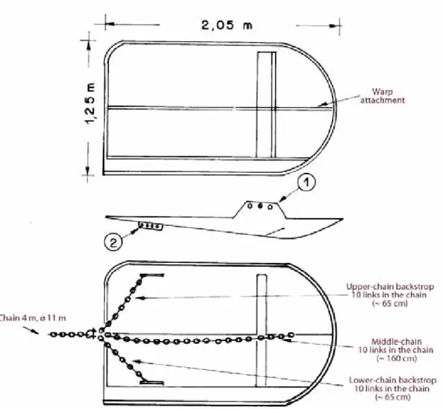
The doors are also normalised. They are of type MorgereWH S (Figure 5 and Figure 6). The
adopted doors correspond to the size number 8. The warp is shackled in the fore hole of the
bracket sheet (see arrow 1 in
Figure
2
). The short parts of the external crowfoot are shackled in the most back part of the
backside sheets, upper and lower (see arrow 2 in
Figure
2
). The length of the backstrops (shackles not included) are as follow:
long external back-strops: 1.60 m
short upper and lower back-strops: 0.65 m (± 10%).
1.4 Warp diameter and length
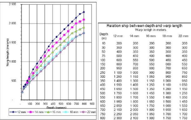
Taking the characteristics of the trawl and the rigging into account, the warps should have a
diameter of 16 mm, with a minimum thickness of 14 mm and a maximum of 22 mm. The length
of warps to be shot is determined by the operating depth. The recommended relationship
between depth and warp length is given in figure 7. Although in certain particular circumstances
some adaptations can be made to this relationship, it is recommended to respect the depth/warp
length ratio as far as possible.
For the vessels which are not equipped with a device to measure the length of warp shot, it is
recommended to standardise the position of the last mark on the warp, for example at the warp
block furthest back.
1.5 Complementary equipment
The systematic use of a device to control the trawl geometry (vertical and horizontal openings,
contact with the bottom) is highly recommended. The sensors should be positioned as shown in
figure 8. If this is not possible, measurements of the trawl geometry should be taken at various
depths on board each vessel at the beginning of the survey to establish a graph. Data about if the
value of the net horizontal opening for each haul was measured
in situ
or estimated, will be
included in the TA data file, as specified further on in this manual.
A net safety recovery system (the pennant) allowing the retrieval of the trawl by the codend can
be installed. As far as possible, it is recommended to secure the lazy line as shown in figure 7
and to take care of its fixations. Rules for the use of the pennant must be adopted in order to
avoid deformations of the gear geometry and drag. Ropes attached to the codend and
terminating with a float must be avoided (Figure 8). Ropes starting from the codend and
terminating to the wing tip are allowed only if connected to the strengthening lacing at regular
intervals (every 1-1.5 m; Figure 8).
[2] Sampling methodology
2.1 Vessel characteristics
The vessels used for the MEDITS surveys should have an engine of at least 370 kW to be able
to tow the standard sampling gear (traction at ground run: 4.5 tons). It is strongly recommended
that as far as possible the same vessel and crew be used every year in each area so as to reduce
variations between years due to vessel effect. The list of the vessels used since the beginning of
the survey series is given in
annex I
.
2.2 Period of the survey
The period of the MEDITS survey is centred around June (from May to July).
2.3 Hauls localisation
The hauls are positioned following a depth stratified sampling scheme with random drawing of
the positions within each stratum. The number of positions in each stratum is proportional to the
area of these strata. Except in the case of peculiar problems (damages noted in previous years,
etc.), the hauls are made in the same position from year to year. The decision to make a haul in
a given place should not be influenced by the presence of fish shoals detected with the sounder
or the sonar.
The following depths are fixed in all areas as strata limits:
10 - 50 m,
50 - 100 m,
100 - 200 m,
200 - 500 m,
500 - 800 m.
Furthermore the strata are limited by lines more or less perpendicular to the coast, depending on
the geographical characteristics of each area. The adopted stratification schemes are shown in
figure 1. It is strongly recommended to maintain the same scheme between years. The strata are
described in
annex II
. The target number of hauls by area is given in
annex III
.
The
Posidonia sp.
meadows are excluded from the sampling scheme and should never be
trawled.
2.4 Operating the gear
2.4.1 Sampling period in the day
The hauls must be performed only during daylight. The daylight period is defined as the time
between 30 minutes after sunrise and 30 minutes before sunset.
2.4.2 Haul speed and duration
The standard fishing speed is 3 knots on the ground. This recommended speed is very important
in order to ensure the best trawl geometry. The actual speed as well as the covered distance
should be monitored and recorded.
It is highlighted that a speed lower than 2.8 knots can have a negative effect on the verticality
and the stability of the doors which can lie down and get stuck in the mud. A speed greater than
3.2 knots can take the trawl off the seabed at great depths.
The haul duration is fixed at 30 minutes on depths less than -200 m and at 60 minutes at depths
more than -200 m. In case during the fishing operations the haul should be stopped before the
In general, hauls should be performed at constant depth. The depth variations during the haul
should not exceed ± 5% relative to the initial depth. The discrepancies to this target should be
recorded. In case of a significant difference between the depth under the vessel as recorded by
the eco-sounder onboard and the depth at which the trawl is, the recorded depth should be taken
as the latter.
As far as possible and in respect of the previous constraints, the hauls should be rectilinear. If
for some reasons that is not possible, the turning circle must be as wide as possible so as not to
disrupt the trawl geometry. In all cases the fields "COURSE" and "DISTANCE" of the "TA"
data file (see § 5.2 and
Annex X
.) should be precisely documented.
2.4.5 Managing the end of shooting operations and the start of the haul
After the complete shooting of the warps and the braking of the winches, a relatively high speed
(5-6 knots) should be maintained for around 1 minute to allow the trawl to open well both in
length and in width. The speed should then be strongly reduced (even to 0) allowing the doors
to reach the seabed. The time required varies depending on the vessel and the depth; for
example 2-3 minutes at 500 m. .Once the doors are on the seabed, a speed lower than the
normal one (2.5-2.7 knots) should be maintained in order to allow the trawl to reach the bottom.
Once the net is well stabilised the speed will be increased towards the standard speed (3 knots);
this moment is defined as the real start of the haul. The above procedure should be respected as
precisely as possible, except in some particular situations where minor adaptations may be
absolutely necessary.
For those vessels using a device such as a SCANMAR Trawl Sensor or SIMRAD, the trawl can
be considered as well stabilised as soon as its vertical opening is between 2 and 3 m. For the
vessels without such a device, preliminary trials shall be made before the survey. The aim of
these trials is to determine ship by ship the time needed for the trawl to operate correctly from
one vessel to another, taking into consideration the approach of each individual skipper.
2.4.6 Setting of the trawl on the ground
It is important that the gear stays in good contact with the seabed during the whole haul. This
should be regularly checked either by an acoustic device during the haul, by the observation
ofthe chains wear or by the observation of benthic organisms in the catches after the haul.
2.4.7 Trawl geometry while fishing
The trawl is designed to have a vertical opening between 2 and 3 meters at the various depths if
the above mentioned adjustments are respected. When a device like the SCANMAR Trawl
Sensor is used, the vertical and horizontal (between the wings) opening should be checked as
often as possible, once the trawl is stabilised. The average values of these two parameters
(disregarding the obviously aberrant values) will be reported in the data file for each haul.
When appropriate instruments to control the gear behaviour are not regularly used, reliable
models of horizontal- and vertical-net opening related to some other available parameters (i.e.
warp length, depth, etc.) should be used. So that estimated values of net openings can be derived
and applied when necessary. Nevertheless the use of these instruments is highly recommended
because they give exact information on the gear behaviour. From one side they give the measure
of the horizontal and vertical net openings in all the conditions, even when some external and
unpredictable effect (i.e. part of the net entangled or damaged, particular types of the bottom)
can influence the above parameters and make the possible estimates inaccurate. From the other
side, the knowledge of the gear behaviour could improve the setting operations and the
determination of the exact tow duration also at high depths.
For each Operative Unit, some specific models of MEDITS gear behavior were produced from
the data collected during the project
“Intercalibration des campagnes internationales de
chautage démersal en Méditerranée central”
(IRPEM-CE project MED/93/015). During trawl
survey, if it will be not possible to use the gear monitoring system due to risky hauls (e.g. rocks,
relicts, etc.), such models should be used to interpolate any missing values. Also, some new
general models have been derived from the pooled data collected during the above mentioned
project. General quantitative predictions of MEDITS gear geometry (e.g. horizontal and vertical
openings) from the other known parameters (e.g. cable length, bottom depth, bridles length,
etc.) will be provided to each Operative Unit after the evaluation of the established Working
Group. We recommend the new MEDITS Units or Units without any gear monitoring system to
adopt these new general models consistently throughout the years in order to keeping eventual
errors constant in the time series.
2.4.8 Wear of the trawl
Since no system has been developed to prevent the bosom of the trawl from rubbing against the
seabed it is recommended that affected sections of the trawl be replaced as needed, particularly
when they have lost their initial resistance characteristics.
2.4.9 Checks of the sampling equipment
During use, the trawls must be checked at regular intervals by taking a number of check
measurements on the geometry of the trawl.
The net should be regularly checked for wear and tear and all damages shall be repaired upon
discovery. The net will eventually stretch under normal fishing conditions. The overall status
for the net should be checked at the beginning of every cruise. Every year a detailed check
should be made of all net and rope dimensions. Special attention should be given to ensure that
the relationship (difference) between the length of the netting sections in the top and bottom
panels are maintained. Lower sections are of the same length than the top sections. These
similar lengths have to be maintained by monitoring the net at regular intervals. In the case that
the difference is larger than 1 mesh size the longer section must be shortened to the proper size.
Also the relationship between the length of the framing ropes and the nets in the wings and arms
must be retained. The percentage the net is stretched on the headline and footrope is given in the
specification (Figure 2). When the netting after a period of use loses its stretch, the headline and
footrope must be cut off, the net in the wings and arms shortened and remounted on the ropes
again.
The trawl consists of four panels: top, bottom and side panels. Each panel has several sections.
It is necessary to check the relative length of each netting section. They are all compared with
the corresponding sections in the other panels in the way that the top and bottom panel sections
are checked against the side panel sections. The best method to compare two sections is to let
two persons – one in each end of the section – take around 10 meshes from the centre line of
one section in one hand and hold it against 10 meshes from the centre line of the other section in
the other hand. The sections must then be stretched and the difference in length observed.
Length of side, top and lower panel sections must be equal. The procedure is repeated for each
Annex V
and
XV
of this manual.
For each species the total weight and number of individuals should be collected
,
excluding
the
f
aunistic category V, G, H for which only the total weight should be collected.
For faunistic
categories D and E, the number of individuals is not mandatory (NM).
When the catch of a given species or a fraction of a given species (e.g. juveniles) is too
abundant to be measured
in extenso
it is reasonable to take a representative sub-sample of the
catch. This sub-sample should be not less than 100 individuals.
The common coding system adopted for the complete set of species (
Annex XV
) is a RUBIN
like coding system as defined in the NCC standard
1, even if this international coding system has
been no longer maintained for some years. This coding system appears to be a very practical
one and it would be very easy in the future to build a correspondence table with any new coding
system. In respect to the NCC recommendations and as the MEDITS coding is not strictly
identical to the RUBIN one (different use, species not referenced to in the RUBIN code), the
"name" of this code has been changed and is for the purpose of the MEDITS called "FM list".
The species identifications are made following Fisher and al, 1987
2. For the fish species not
included in this work, the descriptions from Whitehead
et al
, 1984
3have been used.
Furthermore, a correspondence with the most updated revisions by international bodies (e.g.
Fishbase
4for fish) is given. The 2012 review of the species list is based on the checklist of
Fauna and Flora of Italian seas. Nevertheless, the species coding is to be strictly kept identical
in the data base, even if the scientific species name has been changed, in order to keep the time
series consistant.
It is important to precise the extent of species recorded from the catch
.
Coding for this
information is given in
Annex IV
.
Since 2012, the MEDITS reference list of target species (
Annex VI)
includes 82 species, of
which 32 are Elasmobranches. The list also includes all species of the
Epinepheus
and
Scomber
genera, for which length measurements should be obtained.
For all the 82 species and the two genera mentioned above (
Epinepheus
and
Scomber
) and
reported in
Annex VI,
the total number of individuals, the total weight and the individual length
should be collected.
This list has been further split in two groups:
-
MEDITS G1 includes 41 species with 9 demersal (3 fish, 4 crustaceans and 2
cephalopods) and 32 Selachians. For these species the total number of individuals, the
total weight, the individual length, and also biological parameters including sex, maturity,
individual weight and age (age has been proposed only for the teleosteans of the Group 1)
should be collected;
-
MEDITS G2 includes 43 species for which only total number of individuals, total weight
and individual length should be collected.
If a live specimen of a rare species or a species subject to conservation measures is caught,
efforts should be made to obtain length, weight and sex data and return the specimen back to the
sea unharmed, giving it a chance for survival. The specimens should be returned at sea
preferably within 4-5 minutes.
1
NCC: Nordic code centre (Stockholm).
2
Fisher W., M.L., Bauchaud et M. Shneider (rédact.), 1987. Fiches FAO d'identification des espèces pour
les besoins de la pêche (révision 1). Méditerranée et mer Noire (volumes I et II). Projet
GCP/INT/422/EEC. FAO, Rome: 1530 p.
3
Whitehead P.J.P., M.L. Bauchot, J.C. Hureau, J. Nielsen, E. Tortonese, 1984. Poissons de l'Atlantique du
nord-est et de la Méditerranée (3 volumes). UNESCO, Paris.
3.2 Biological parameters
3.2.1 Measurement units
For fish (bony fish and Elasmobranches) the total length.with the tail fully extended should be
recorded). The measurement unit is the lower half centimetre. For crustaceans the
cephalo-thoracic length at the lower millimetre should be measured, while for cephalopods, the dorsal
mantle length at the lower half centimetre should be obtained. For octopods the measure is
taken along the line passing through the eyes. Sketches of the standard measurements to be
obtained are reported in the
Annex VII
.
If a given team wishes to make complementary observations on other species or of another
nature, for its own works, it is kindly invited to inform the MEDITS Group (Co-ordination and
Steering Committees) to eventually allow to normalise the methodology with other research
teams.
3.2.2 Sex and maturity
The sex is defined following four categories: male, female, undetermined (impossible to
determine it by eye) and not determined (the individual has not been examined).
Sex data is presented at the individual level in the newly introduced TE file (
Annex XIII
) and
at the aggregated level in the TC file (
Annex XII
). The latter is necessary for estimating the sex
ratio of the target species.
The sexual maturity is defined using the maturity scales given in
Annex VIIIa-VIIIe
for the
fish, crustaceans and cephalopods. The staging reported in the blue column must be adopted.
The individuals of hermaphrodistic species undergoing a change in sex when observed, are
qualified into the sex showing the more developed gonads.
The former MEDITS scale for the description of elasmobranch maturity stages referred only to
oviparous species (Rayadae and Scyliorhinidae). However the majority of elasmobranchs are
viviparous or ovoviparous which have a great diversity in ovarian cycles and gestation periods.
The examination of male maturity does not present particular problems, considering that they
are classified according to the relative sizes and development of claspers and internal
spermiducts. For females it is necessary to apply the dissection of the individual to observe the
presence of oocytes and the formation of egg-cases in mature oviparous individuals. For this
reason it is opportune to use a specific scale for the viviparous and ovoviviparous species
usually fished in the Mediterranean sea as well as
Squalus acanthias
,
Squalus brainvillei
,
Etmopterus spinax
,
Torpedo
spp.,
Dasyatis
spp. for which the reproductive biology is less
investigated in several of the Mediterranean areas. For these reasons the maturity scale for
viviparous elasmobranches adopted at WKMSEL 2010 (Ices, 2010) is reported in the
Annex
VIIIc
.
While all maturity stages during the MEDITS survey, should be reported using the MEDITS
maturity scales
,
a conversion of these maturity scales to the scales proposed at the Workshops
on Maturity stages is provided in
Annex IX
in case needed.
the same species should also be collected.
Otoliths of routinely assessed species should also be collected for age determination, useful to
estimate,
inter alia
, the probability reaction norm of maturation (PRNM) i.e. the indicator n. 4
of Data Collection Framework (Commission Decisions n. 949/2008 and SEC(2008) 449).
The above decisions were also approved by the 8
thRegional Coordination Meeting of the
Mediterranean and Black Sea held in Ljubljana (Slovenia) on May 10-13, 2011.
The decisions taken during the MEDITS coordination meeting in Ljubljana (March, 6-8, 2012)
based on the above mentioned document are reported in
Annex XIV
that represents the
sampling protocol to collect the biological information related to otoliths, individual weight and
maturity stage by sex from MEDITS survey 2012.
Due to these changes, a new file type; the TE file (
Annex XIII
), was introduced in order to
store individual data. Consequently, new specifications were introduced in the TC file (
Annex
XII
).
3.3 Other parameters
The bottom water temperature should be recorded at the start and the end of each haul. This
information should be stored in the TA exchange file with the format defined in the
Annex X
.
Thus also the TA file format has been changed and information before included in TD file has
been here incorporated.
The former recommended sensor was the Vemco minilog TDR –5 to 35°C, however this sensor
is currently out of production. It can be replaced by other devices such as the one produced by
Star-Oddi. It should be fixed on the bosom head line. It is important that the clock of the
computer which receives the data from the sensor is exactly set accordingly with the UT time
(GMT) to have the same times as in the TA file. The temperatures from all the hauls (beginning
and end) should be kept and reported in the TA file. These temperature should correspond to the
official time of beginning and end of the haul, assuming that the trawl begins and stops to work
properly at these official times.
[4] Inter-calibration of the work at sea
Two possibilities are recommended for the inter-calibration of the working methods between
the various vessels:
•
an exchange of scientists on board the vessels.
•
a co-ordinated trawling operation by the two vessels at the border of the areas covered
by these two vessels.
To favour the exchange of scientists one place will be reserved on board of each vessel for the
eventual boarding of a scientist from another team. In addition, each co-ordination group will do
their best to send a scientist from their own team on board of other vessels participating in the
project. It is expected that the reports of these boardings help to identify eventual differences in
the working methodology.
Where and when different teams are in charge of adjacent working areas, even though rather
difficult and time consuming, they are invited to try and organise some common hauls in
parallel to reach an inter-calibration between the two vessels.
[5] Data exchange formats
Standard formats are defined for the storage and to facilitate the exchange of the data produced
by the MEDITS surveys. The exchange files are in .csv format, using semicolon as field
separator.
5.2 Files type
Four file types are defined in order to store and exchange the data: Type A: Characteristics of
haul (
Annex X
) - this file now includes the data on bottom temperature and stratification,
formely included in TD and TT type files; Type B: Catches by haul (
Annex XI
); Type C:
Length, sex, and maturity at aggregated level (
Annex XII
); Type E: Age weight and maturity
by length at individual level (
Annex XIII
).
The file names are defined as follow:
Position
Variable
Possible values
Character 1
Files type
A
(haul characteristics)
B
(catch by
haul)
C
(biological parameters at
aggregated level)
E
(biological
parameters at individual level)
Character 3
Country
MLT
,
ESP
,
FRA
,
ITA
,
SLO
,
HRV
,
ALB
,
MON
,
MOR
,
ML
,
GRC, CYP
Character 4-5
Area
See Annex III
Character 6-9
Year
2000
,
2001
, etc.
Character 10
Separator
.
(point)
Character 11-13
Extension
csv
5.3 Files structure and information's coding
The exchange files format are described in
Annexes X to XIII
. Complementary coding tables
used to fill in the data files are given in the annexes referred above.
[6] Gear standardization and monitoring
At the MEDITS coordination meeting in Ljubljana (Slovenia, March 6-8, 2012), it was decided
to include in this manual further technical specifications regarding the sampling gear (e.g. gear
parameters, quality checks related to the gear), as well as to establish a multidisciplinary
working group to progress in the harmonization of the the MEDITS samplings in the
Mediterranean Sea.
The tasks of this WG can be synthesised as follows:
meeting held in Ljubljana (Slovenia, 6-8 March 2012).
The present revision of the technical specifications of the MEDITS manual regarding the gear
characteristics and the relevant quality checks should be considered preliminary as they will be
further implemented by the established WG. The new multidisciplinary group should report
regularly to the MEDITS coordination group the findings of the investigations.
[7] Other aspects (MEDITS Rules)
MEDITS internal rules were adopted during the MEDITS meeting, Split (Croatia),
15-16/06/2010 and are reported in the
Annex XVI
.
FIGURES
Fig. 1. General map of the area covered by the programme. Top: the GFCM GSAs, Down: the
MEDITS strata.
The designations used and the presentation of cartographic data imply no line as for the
juridicial status of the various areas neither as for the border lines between countries.
Fig. 2. Design of the GOC 73 trawl used for the MEDITS survey. It is very important to
maintain the original relationship (hanging ratio, difference in length) between the netting
lengths and the framing ropes along the headline and footrope.
Note to netmakers
: The numbers of meshes shown for netting
pan
el widt
hs do
not inclu
de selvedge meshes. Five meshes
(six knots) pe
r selvedge must be added
where indicated . Conve
rsely to o
btain p
anel depths o
ne row (1/2
mesh) must b
e
subtracted from ea
ch panel as the joining row is
included inm the number of mesh
Fig. 3. Gear rigging details adopted for the MEDITS trawl. For the letter A, B, C, D and E refer
to Figure 4.The length of the 1 m chain (D) must be adjusted in order to obtain the upper- (steel)
and the lower-bridle (combination rope + chain) of the same length (30 m). See Figure 4 for
further details.
A
B
C
D
E
Fig. 4. Various details of the MEDITS trawl gear rigging. The length of the chain (*) must be
adjusted in order to obtain the upper- (steel) and the lower-bridle (combination rope + chain) of
the same length (30 m). The tickler chain must be rigged at the tip of the lower-bridle.
Figure 1. Main characteristics of the Morgere W Horizontal (WH) otterboards. For the MEDITS
program it was selected the WS8 type. The otterboard weight refers to without- and with-plates
in the shoe.
Figure 2. Morgere WS8 (350 kg; 2.5 m
2). The lengths of the backstrop chains are indicated
without the shackles. The warp is shackled in the fore hole of the bracket sheet (see arrow 1).
The short parts of the external crowfoot are shackled in the most back part of the backside
sheets, upper and lower (see arrow 2).
A B
Fig. 8. A. Position of the geometry sensors and drawing of the lazy line.
B. Details of the pennant adopted for the MEDITS trawl. The pennant must be fixed both at the
wing tip and at the codend closure. The pennant must be sewed every 3.6 m at the starboard
strengthening lacing
[6] Annexes
I.
C
ODE OF COUNTRIES,
VESSELS AND GEARII.
S
TRATIFICATION SCHEMEIII.
T
ARGET NUMBER OF HAULS BY AREAIV.
C
ODE OF RECORDED SPECIES,
OF GENERAL OBSERVATIONS ON HAULS AND OF QUADRANTSV.
C
ODE OF FAUNISTIC CATEGORIES.
F
ORM TO INTRODUCE NEW SPECIESVI.
L
IST OF REFERENCE SPECIESVII.
S
TANDARD LENGTH MEASUREMENT FORC
RUSTACEANS,
C
EPHALOPODS BONY FISH ANDE
LASMOBRANCHESVIII.
C
ODES OF SEXUAL MATURITY FORF
ISH,
C
RUSTACEANS ANDC
EPHALOPODSIX.
P
ROTOCOL FORC
ONVERSION OF MATURITY SCALES FROM THE SCALES PROPOSED AT THEW
ORKSHOPS ONM
ATURITY STAGES AND THEMEDITS
SCALESX.
F
ORMAT OF THE TYPEA
FILES(D
ATA ON HAULS)
XI.
F
ORMAT OF THE TYPEB
FILES(C
ATCHES BY HAUL)
XII.
F
ORMAT OF THE TYPEC
FILES(L
ENGTH,
SEX AND MATURITY AT AGGREGATED LEVEL)
XIII.
F
ORMAT OF THE TYPEE
FILES(A
GE,
WEIGHT AND MATURITY BY LENGTH AT INDIVIDUAL LEVEL)
XIV.
P
ROTOCOL FOR SAMPLING OTOLITHS,
INDIVIDUAL WEIGHT AND MATURITY STAGE OFMEDITS
TARGET SPECIESXV.
P
RELIMINARY CONSIDERATIONS FOR QUALITY CHECKS OF THE GEAR(
BYA
NTONELLOS
ALA)
XVI.
FM
LIST OF SPECIES CODESI.
C
ODES FOR COUNTRIES,
VESSELS AND GEARCodes for countries
(Position 3-5 in the file A)
Code Country
ALB
Albania
CYP
Cyprus
ESP
Spain
FRA
France
GRC
Greece
HRV
Croatia
ITA
Italy
MLT
Malta
MOR Morocco
MON Montenegro
SLO
Slovenia
Vessel codes and characteristics (Vessel code:
Position 8-10 in the file A)
Vessel code
Vessel Name Type Length (m)
Tonnag e (TJB)
Year Material Power (kW) Warp diam (mm) Warp length (m)
AND Andrea R 29.5 211 1998 aluminium 1300 14 2250
BIM Bianca Maria P 26.81 116 1988 wood 485 12 3000
CHA Charif Alidrissi R 41 397 1986 steel 808 22 3000
COR Cornide de Saavedra R 66.7 1524 1970 steel 1651 29 2700
DAP Dalla Porta R 35.3 285 2000 steel 809 14 2500
DEM Demetrios P 27.77 78.24 1991 steel 537 12 3000
EGU Elisa Guidotti P 29 69 1991 bois 330 14 2500
EVA Evagelistria P 29.1 59.45 2000 steel 497 12 1800
FRP Francesco Padre P 25 88 1984 steel 660 14 3000
FUL Fulmine P 29 147.2 0 wood 736 14 2500
GAB Gabriella P 23 64 1970 wood 441 12 3500
GIS Gisella P 29.3 168 1999 iron 432 15 3000
IGO Igor P 22.5 102 1979 iron 345 14 2500
IRO Ioannis Rossos P 26.3 115.75 1986 iron 368 12 3000
LEU L'Europe R 29.6 259.69 1993 aluminium 690 16 2700
LIB Libera P 22.3 69 1987 wood 441 14 2500
MEG Megalochari P 33 150 2005 steel 367 12 2000
NAU Nautilos P 28.4 138 1991 iron 600 14 2500
NAV Francisco Paula
Navarro
R 30.5 178 1987 wood 750 18 2200
NUS Nuovo Splendore P 29.45 134.51 1967 wood 685 16 2450
PAR Kapetan Paraschos P 26.1 85.71 1989 wood 386 12 2000
PEC Pasquale e Cristina P 33.06 158.77 1996 wood 923 16 2500
PRI Principessa I P 32 165 1995 steel 403 14 2500
ROS Roselys R 0 0 0 wood 0 0 0
Codes for the gear (MEDITS code:
Position 11-23 in the file A)
Nature Gear MEDITS
code
Comments
Trawl
Large opening and 4 faces
GOC73
Standard for all vessels
Rigging
With legs
GC73
Standard for all vessels
II.
S
TRATIFICATION SCHEME(
BY STRATUM NUMBER)
(S
TRATUM:
P
OSITION125-129
IN THE FILEA)
GSA Country Stratum Depth (m) Surface (km²) Area 1 Spain 11101 a 10-50 510 Alboran Sea 1 Spain 11102 a 50-100 1951
1 Spain 11103 a 100-200 1086 1 Spain 11104 a 200-500 3461 1 Spain 11105 a 500-800 4912
2 Spain 11106 b 10-50 0 Alboran Island 2 Spain 11107 b 50-100 130 Alboran Island 2 Spain 11108 b 100-200 132
2 Spain 11109 b 200-500 221 2 Spain 11110 a 500-800 350
3 Morocco 11401 a 10-50 355 West Morocco 3 Morocco 11402 a 50-100 444
3 Morocco 11403 a 100-200 487 3 Morocco 11404 a 200-500 3580 3 Morocco 11405 a 500-800 1108
3 Morocco 11406 b 10-50 878 East Morocco 3 Morocco 11407 b 50-100 1098
3 Morocco 11408 b 100-200 938 3 Morocco 11409 b 200-500 3507 3 Morocco 11410 b 500-800 1446
5 Spain 11501 a 10-50 0 West Baleares 5 Spain 11502 a 50-100 1170 West Baleares 5 Spain 11503 a 100-200 1773
5 Spain 11504 a 200-500 1123 5 Spain 11505 a 500-800 2030
5 Spain 11507 b 50-100 2255 East Baleares 5 Spain 11508 b 100-200 1472 5 Spain 11509 b 200-500 1518 5 Spain 11510 b 500-800 1315 6 Spain 11201 a 10-50 1130 Valenciana 6 Spain 11202 a 50-100 4095 6 Spain 11203 a 100-200 3302 6 Spain 11204 a 200-500 4242 6 Spain 11205 a 500-800 3159 6 Spain 11301 a 10-50 1896 Tramontana 6 Spain 11302 a 50-100 7219 6 Spain 11303 a 100-200 3587 6 Spain 11304 a 200-500 2477 6 Spain 11305 a 500-800 1399
7 France 12101 a 10-50 1482 West Gulf of Lions 7 France 12102 a 50-100 3911
7 France 12103 a 100-200 819 7 France 12104 a 200-500 709 7 France 12105 a 500-800 660
7 France 12106 b 10-50 696 East Gulf of Lions 7 France 12107 b 50-100 2610
7 France 12108 b 100-200 1734 7 France 12109 b 200-500 653 7 France 12110 b 500-800 586
8 France 13101 a 10-50 0 North East Corsica 8 France 13102 a 50-100 521 North East Corsica 8 France 13103 a 100-200 234
8 France 13104 a 200-500 920 8 France 13105 a 500-800 867
GSA Country Stratum Depth (m) Surface (km²)
Area
8 France 13106 b 10-50 0 South East Corsica 8 France 13107 b 50-100 524 South East Corsica 8 France 13108 b 100-200 153
8 France 13109 b 200-500 383 8 France 13110 b 500-800 960
9 Italy 13201 a 10-50 657 North Ligurian Sea 9 Italy 13202 a 50-100 729
9 Italy 13203 a 100-200 658 9 Italy 13204 a 200-500 1737 9 Italy 13205 a 500-800 2093
9 Italy 13206 b 10-50 2053 East Ligurian Sea
9 Italy 13207 b 50-100 1598
9 Italy 13208 b 100-200 3186 9 Italy 13209 b 200-500 2449 9 Italy 13210 b 500-800 879
9 Italy 13211 c 10-50 945 North Tyrrhenian Sea
9 Italy 13212 c 50-100 1506
9 Italy 13213 c 100-200 2732 9 Italy 13214 c 200-500 2828 9 Italy 13215 c 500-800 3071
9 Italy 13216 d 10-50 2107 Central Tyrrhenian Sea
9 Italy 13217 d 50-100 2159
9 Italy 13218 d 100-200 4302 9 Italy 13219 d 200-500 3573 9 Italy 13220 d 500-800 3148
10 Italy 13401 a 10-50 1194 South East Tyrrhenian Sea 10 Italy 13402 a 50-100 1224
10 Italy 13403 a 100-200 2095 10 Italy 13404 a 200-500 3238 10 Italy 13405 a 500-800 5248
10 Italy 13406 b 10-50 622 South West Tyrrhenian Sea 10 Italy 13407 b 50-100 1003
10 Italy 13408 b 100-200 1224 10 Italy 13409 b 200-500 1966 10 Italy 13410 b 500-800 2441
11 Italy 13301 a 10-50 822 South East Sardinia 11 Italy 13302 a 50-100 382
11 Italy 13303 a 100-200 351 11 Italy 13304 a 200-500 589 11 Italy 13305 a 500-800 502
11 Italy 13306 b 10-50 910 North East Sardinia 11 Italy 13307 b 50-100 1592
11 Italy 13308 b 100-200 839 11 Italy 13309 b 200-500 765 11 Italy 13310 b 500-800 855
11 Italy 13311 c 10-50 627 North Sardinia 11 Italy 13312 c 50-100 796
GSA Country Stratum Depth (m) Surface (km²) Area
11 Italy 13323 e 100-200 927
11 Italy 13324 e 200-500 412
11 Italy 13325 e 500-800 260
11 Italy 13326 f 10-50 783 South West Sardinia
11 Italy 13327 f 50-100 987
11 Italy 13328 f 100-200 2335 11 Italy 13329 f 200-500 1620 11 Italy 13330 f 500-800 1041
11 Italy 13331 g 10-50 705 South Sardinia
11 Italy 13332 g 50-100 350 11 Italy 13333 g 100-200 768 11 Italy 13334 g 200-500 1060 11 Italy 13335 g 500-800 1227 15 Malta 13501 a 10-50 152 Malta 15 Malta 13502 a 50-100 1473 15 Malta 13503 a 100-200 3076 15 Malta 13504 a 200-500 3353 15 Malta 13505 a 500-800 2526
16 Italy 13411 c 10-50 3145 Strait of Sicily
16 Italy 13412 c 50-100 6610
16 Italy 13413 c 100-200 9866 16 Italy 13414 c 200-500 13424 16 Italy 13415 c 500-800 15653
17 Italy 21101 a 10-50 17300 North Adriatic Sea
17 Italy 21102 a 50-100 8200
17 Italy 21103 a 100-200 0
17 Italy 21104 a 200-500 0
17 Italy 21105 a 500-800 0
17 Italy 21106 b 10-50 4700 Central Adriatic Sea
17 Italy 21107 b 50-100 10350
17 Italy 21108 b 100-200 14950 17 Italy 21109 b 200-500 3900
17 Italy 21110 b 500-800 950
17 Slovenia 21111 c 10-50 184 North Adriatic-Slovenia 17 Slovenia 21112 c 50-100 0
17 Slovenia 21113 c 100-200 0 17 Slovenia 21114 c 200-500 0 17 Slovenia 21115 c 500-800 0
17 Croatia 21116 d 10-50 7308 North East Adriatic-Croatia 17 Croatia 21117 d 50-100 14785
17 Croatia 21118 d 100-200 7225 17 Croatia 21119 d 200-500 2409 17 Croatia 21120 d 500-800 0
18 Italy 22121 e 10-50 261 South West Adriatic Sea
18 Italy 22122 e 50-100 509
18 Italy 22123 e 100-200 1348
18 Italy 22124 e 200-500 332
18 Italy 22125 e 500-800 860
18 Italy 22126 f 10-50 329 South West Adriatic Sea
18 Italy 22127 f 50-100 599
18 Italy 22128 f 100-200 1809
18 Italy 22129 f 200-500 472
18 Italy 22130 f 500-800 350
18 Italy 22131 g 10-50 290 South West Adriatic Sea
18 Italy 22132 g 50-100 689
18 Italy 22133 g 100-200 1214
GSA Country Stratum Depth (m) Surface (km²) Area 18 Italy 22135 g 500-800 336
18 Italy 22136 h 10-50 1702 South West Adriatic Sea 18 Italy 22137 h 50-100 1307
18 Italy 22138 h 100-200 1407 18 Italy 22139 h 200-500 707 18 Italy 22140 h 500-800 492
18 Albania 22141 i 10-50 568 South East Adriatic-Albania 18 Albania 22142 i 50-100 2231
18 Albania 22143 i 100-200 2186 18 Albania 22144 i 200-500 1840 18 Albania 22145 i 500-800 1910
18 Montenegro 22146 j 10-50 280 South Adriatic-Montenegro 18 Montenegro 22147 j 50-100 1100
18 Montenegro 22148 j 100-200 1700 18 Montenegro 22149 j 200-500 1150 18 Montenegro 22150 j 500-800 770
19 Italy 22101 a 10-50 412 North-Western Ionian Sea (East Sicily) 19 Italy 22102 a 50-100 377
19 Italy 22103 a 100-200 334 19 Italy 22104 a 200-500 650 19 Italy 22105 a 500-800 641
19 Italy 22106 b 10-50 326 North-Western Ionian Sea (South Calabria) 19 Italy 22107 b 50-100 225
19 Italy 22108 b 100-200 257 19 Italy 22109 b 200-500 939 19 Italy 22110 b 500-800 1370
19 Italy 22111 c 10-50 599 North-Western Ionian Sea (North Calabria) 19 Italy 22112 c 50-100 321
19 Italy 22113 c 100-200 393 19 Italy 22114 c 200-500 1327 19 Italy 22115 c 500-800 1190
19 Italy 22116 d 10-50 787 North-Western Ionian Sea (Apulia) 19 Italy 22117 d 50-100 778
19 Italy 22118 d 100-200 1680 19 Italy 22119 d 200-500 1439 19 Italy 22120 d 500-800 2302
20 Greece 22201 a 10-50 2916 East Ionian Sea 20 Greece 22202 a 50-100 4365 20 Greece 22203 a 100-200 2536 20 Greece 22204 a 200-500 3158 20 Greece 22205 a 500-800 3848 22 Greece 22301 a 10-50 2467 Argosaronikos 22 Greece 22302 a 50-100 587 22 Greece 22303 a 100-200 7143 22 Greece 22304 a 200-500 6074 22 Greece 22305 a 500-800 8645
22 Greece 22401 a 10-50 8645 North Aegean Sea 22 Greece 22402 a 50-100 8489
22 Greece 22403 a 100-200 15823 22 Greece 22404 a 200-500 19774
III.
T
ARGET NUMBER OF HAULS BY AREA(
BASED ON2002
ONWARDS RECORDS)
Country GSA
Strata
Surface
(km²)
No
Hauls Area
Spain
1, 2
111
12753
35
Northern Alboran Sea
Morocco
3
114
13841
Southern Alboran Sea
Spain 5
115
12656
53
Balearic
Islands
Spain 6
112-113
32506
82
Northern
Spain
France
7, 8
121, 131
18422
90
Gulf of Lions & Corsica
Italy
9
132
42410
120
Ligurian, North and Central Tyrrhenian
Sea
Italy
10
134a-b
20255
70
Central and Southern Tyrrhenian Sea
Italy 11
133
26975
101
Sardinia
Malta 15
135
10580
44
Malta
Italy
16
134c
48698
120
Strait of Sicily
Italy
17
211a-b
60350
120
Northern Adriatic Sea
Slovenia
17
211c
184
2
Northern Adriatic Sea
Croatia
17
211d
31727
60
Northern Adriatic Sea
Italy
18
221e-h
15273
53
Southern Adriatic Sea
Albania
18
221i
8735
27
Southern Adriatic Sea
Montenegro
18
221j
5000
10
Southern Adriatic Sea
Italy
19
221a-d
16347
70
North-Western Ionian Sea
Greece 20
222
16823 32
Eastern
Ionian
Sea
Greece 22
223
24916 21
Aegean Sea (Argosaronikos)
Greece
22
224
68157
65
Aegean Sea (North)
Greece
22
225
62601
61
Aegean Sea (South)
IV.
C
ODES FOR RECORDED SPECIES,
OF THE OBSERVATIONS ON HAULS AND OF QUADRANTSCodes of recorded species (Position 85 in the file A)
MEDITS code Nature
Comments
0
No standard species recorded
1
Only the species of the reference list are recorded
See Annex VI
2
The species of the reference list plus some others are
recorded
3
All the caught species are recorded
See Annex XV
4
Species from a national list
Coding of the observations (Position 112 in the file A)
MEDITS code Nature
Comments
0
No problem
1
Slight plugging of the net
2
Heavy plugging of the net
3
High abundance of jellyfish
4
High abundance of plants in the net
5
Tears of the net
6
High abundance of benthos
7
8
9
Other
Coding of the quadrants (Positions 41 and 63 in the file A)
Greenwich Meridian
7
1
Equator