Victorian Mapping and Address Service
Incorporating the spatial smart tag™ systemSystem Overview
And
Trial Access Definition & Request Form
Victorian Government
1. INTRODUCTION
This document contains an overview of the components of the Victorian Mapping and Address Service (VMAS).
The purpose of this document is to provide an introduction to VMAS and various components that are available, firstly as part of a production deployment, and secondly as part of a TEST service - which can be applied for with the request form located at the end of this document.
2. VMAS AND THE SPATIAL SMART TAG™ SYSTEM
It is now commonplace for government to demand technology platforms with highly flexible integration capabilities. The Victorian Mapping and Address Service (VMAS) provides proven address verification capabilities in a highly robust and functionally diverse Microsoft .Net web service framework; with user access to this system via the spatial smart tag™ product.
In addition to the powerful request functionality, the system also supports innovative real time system logging. The geocoded use log not only records all address information not found in the authorative database, but also enables highly informative enquiry statistics aggregated to ABS statistical boundaries.
In essence, the VMAS offers customers a single web service (XML) interface with the following features:
Clean, verified address data, single authoritative source Victorian (VICMAP) Property address verification Australian (G-NAF) Property address verification
Address Matching Approval System (AMAS) approved Postal address verification A-spatial (text based) location verification
Usage statistics based on Australian Bureau of Statistics (ABS) mesh blocks Spatial data layer querying
Maps, images and spatial information
Process and transaction gains, through pre-population of forms and access to ‘place-based’ information
Simple and effective means of monitoring and managing system access
3. SYSTEM COMPONENT BRIEF
VMAS consists of three service components. Descriptions of the components are detailed in the tables below. SII makes available a limited TEST service to allow clients to trial the VMAS web service functionality.
The highlighted BLUE components are available through the TEST service. The TEST web service is provided free of charge to accepted users. The TEST service request form is attached.
Table 1. VMAS Components
Component Description Technology
Notes Server Applications and components
(Server Tier)
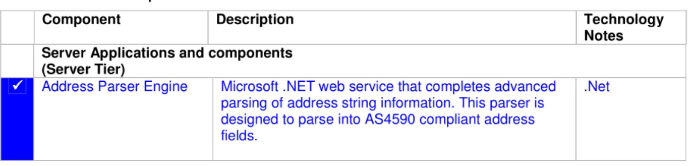
Address Parser Engine Microsoft .NET web service that completes advanced parsing of address string information. This parser is designed to parse into AS4590 compliant address fields.
Component Description Technology Notes G-NAF Address Verification Engine
Microsoft .NET application that completes G-NAF Address Verification. (G-NAF data stored in Oracle 10g Spatial Locator schema.) Use of this engine within the solution is controlled by VMAS Function Service. A variety of geocode levels may be requested and configured.
.Net
a-spatial Finder Engine Microsoft .NET application that completes a-spatial (text based) point location verification. This system is configured to support the return of spatial information based on input of latitude and longitude.
Examples of data that may be returned by this engine include:
Administrative Boundaries (eg LGA)
Street Directory References (eg Melway Page and Grid references)
This engine is available with 1) Basic, 2) a-spatial and 3) Advanced functions.
1) Basic functions include:
Customisable lookup (or directory look-up) functionality for polygon features only
Point in polygon queries
2) A-spatial functions include (Basic functions plus):
Customisable lookup (or directory look-up) functionality for any database VIEW
Basic text matching queries
.Net
VMAS Usage Logs (inc. Secure Geocoded Use Log)
A relational database schema deployed in an Oracle instance to support the use metering, spatial use logging and reporting functionality of the VMAS Administration Web Service. Note that it is possible for the schema to be deployed on alternate databases. (eg. MS SQL Server)
SQL (Oracle)
VMAS Dataset Storage A set of relational database schemas deployed in Oracle to support the storage and querying of the spatial datasets.
Table 2. SST components
OPTIONAL Package Component. Blue
indicates available for TEST service.
Description Technology
Notes
Desktop viewable components (client tier)
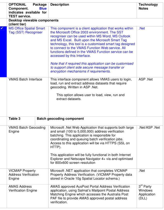
MS Office Spatial Smart Tag (SST) Recogniser
This component is a client application that works within the Microsoft Office 2003 environment. The SST recogniser can be used within MS Word, MS Outlook and MS Excel. Built upon the Microsoft Smart Tag technology, this tool is a customised smart tag designed to connect to the VMAS Function Web service. All functions defined in the VMAS Function service can be accessed by this Interface.
Note that if required this application can be customised to support client side secure message transfer or encryption mechanisms if requirements.
.Net
VMAS Batch Interface This interface component allows VMAS users to login, load, run and extract address datasets that require geocoding. Written in ASP .Net.
This option allows user to load, view, run and extract datasets.
ASP .Net
Table 3 Batch geocoding component
VMAS Batch Geocoding Engine
Microsoft .Net Web Application that supports both large and small (100 to 5,000,000) address verification batching. This application is responsible for coordinating and queuing batch verification jobs. Access to this application will be via HTTPS (SSL on HTTP).
This application will be fully functional in both Internet Explorer and Netscape Navigator 4+ via and optimised for 800x600 screen resolution
.Net/ASP .Net
VICMAP Property Address Verification Engine
Microsoft .NET application that completes VICMAP Property Address Verification. (VICMAP Property data stored in Oracle 10g Spatial Locator schema.)
.Net
AMAS Address Verification Engine
AMAS approved AusPost Portal Address Verification application, using Salmat’s Mailpoint Postal Address Matching Engine which accesses the Australia Post PAF file to provide AMAS approved postal address
3rd Party Windows Application (DLL)
4. VMAS TEST SERVICE REQUEST FORM
SII offers clients an opportunity to test the VMAS Web service. The following request form defines the standard functions available through the VMAS TEST Web Service.
TEST WEB SERVICE ACCESS YES/NO COMMENTS
Address Services
Address Parser Engine G-NAF Address Verification Engine
VICMAP Property Address Verification Engine a-spatial Finder Engine
Find Latitude/Longitude Find Melways Reference Find ABS Mesh Block
Find “Client Specific” Client specific boundaries can be loaded and included as a “point in polygon” TEST web service function.
MapViewer
Topographic image (various layers) Standard Cadastre image
Get Melways image (Melbourne,Sydney,Brisbane)
Get Aerial Imagery
OTHER TEST SERVICES YES/NO COMMENTS
Batch Address Geocoding Evaluation
Please discuss requirements with SII. Fees may be applicable.
Please provide the following network access information.
TEST WEB SERVICE ACCESS YES/NO COMMENTS
Spatial Smart Tag Word Recogniser Please advise SII contact of internal Proxy server configuration.
Office 97 - Not Available
Office 2000 - Not Available
Office XP (2002) - Not Available
Office 2003 XML(SOAP) WDSL Compliant
Language Interface.
Please advise SII contact of web services tools utilised.
MS .NET JAVA Other (Please Specify)