A SYNTHESIS OF RIGHTS-OF-WAY NATIVE PLANT COMMUNITIES: IDENTIFYING THEIR RELEVANCE TO HISTORICAL AND
CONTEMPORARY PIEDMONT SAVANNAS
Nicholas S. Adams
A thesis submitted to the faculty of the University of North Carolina at Chapel Hill in partial fulfillment of the requirements for the degree of Master of Science in Ecology in
the Curriculum for the Environment and Ecology.
Chapel Hill 2012
Approved by:
Dr. Robert K. Peet
Dr. John L. Randall
ABSTRACT
NICHOLAS S. ADAMS: A synthesis of rights-of-way native plant communities: identifying their relevance to historical and contemporary Piedmont savannas (Under the direction of Robert K. Peet, John L. Randall, and Alan S. Weakley)
The presettlement Piedmont landscape supported an apparent abundance of
fire-maintained landscapes, including Piedmont savannas. A loss of fire on the natural
landscape led to a decline of fire-tolerant, sun-loving native herbaceous plants that had
persisted for thousands of years. These plants are now restricted to few natural areas, and
a suite of rights-of-way where frequent mowing has favored them. There is great interest
within the conservation community in restoring these management-intensive savanna
landscapes.
Thirty-one rural rights-of-way displaying savanna-like herbaceous vegetation in
the North Carolina Piedmont were surveyed in order to build a reference for managers
wishing to restore savannas. Four distinct vegetative groups and their environmental
preferences were identified. This information was then used to determine which group(s)
DEDICATION
To Margaret and Robbie for their naturalistic spirits, and to my father and mother for
ACKNOWLEDGEMENTS
I would like to acknowledge the multitude of people who helped me in various
capacities to see this project through to its completion. I would first like to thank my
advisor, Johnny Randall, for his invaluable support and advice throughout this project. I
also thank Robert Peet and Alan Weakley for their crucial feedback and support. I realize
their personal enthusiasm for this particular subject, and was proud to contribute to it
with my project. I am grateful for the generous summer support provided by the Alma
Holland Beers and Coker Fellowships, without which I would not have been able to
conduct my fieldwork.
I am immensely grateful to Dr. Jack Weiss for his help and advice on statistical
and other matters. And I thank Dr. Jaye Cable, whose generosity in making time to assist
me in carrying this thesis through to its completion was extremely valuable, extremely
appreciated, and timely.
I would like to acknowledge the personal support and academic advice from my
peers in the Plant Ecology Lab, as well as the Ecology Graduate Program. I thank Forbes
Boyle and Michael Lee for taking the time to brief me about the complexities of CVS
data and proper analysis. And I thank Jackie White for expanding my mind by
challenging my presumptions about Ecology and Conservation.
I am appreciative of the support from the folks at the North Carolina Botanical
Brian Miller, Matt Simon, and Andrew George are friends who were, thankfully,
wellsprings of information and feedback valuable to my project. I also thank Jasper
McChesney for his endless support and advice. I thank them immensely. In that vein, I
would also like to thank the wonderful community of friends that I gained during my
time in this program. Their support was a force in keeping my head on straight.
TABLE OF CONTENTS
LIST OF TABLES ... viii
LIST OF FIGURES ... ix
Introduction ... 1
Chapter I. A REVIEW OF THE PIEDMONT SAVANNA ... 5
Savanna characterization ... 5
Natural history of Piedmont savannas ... 11
Fire ... 16
Conclusion ... 18
II. AN INVESTIGATION AND SYNTHESIS OF SAVANNA-LIKE VEGETATION ON RIGHTS-OF-WAY ... 22
Methods ... 24
Results ... 30
III. THE APPLICABILITY OF RIGHTS-OF-WAY VEGETATION AS REFERENCE DATA FOR SAVANNA RESTORATION IN THE NORTH
CAROLINA PIEDMONT ... 44
Methods ... 49
Results ... 52
Discussion ... 53
Conclusion ... 64
APPENDICES ... 65
LIST OF TABLES
1.1. Historical documentation of open conditions in the Piedmont ... 20
1.2. Documented natural communities with more open canopies and an herb layer ... 20
2.1. Indicator species lists for each rights-of-way plot group ... 32
2.2. Indicator species lists for each rights-of-way plot group ... 33
2.3. Indicator species lists for each rights-of-way plot group ... 33
2.4. Indicator species lists for each rights-of-way plot group ... 34
2.5. Mean value of each environmental variable for each rights-of-way plot group ... 35
3.1. Legend for renamed SSHF grid locations ... 50
3.2. Table of distance measures between rights-of-way edaphic data and Southern Shagbark Hickory Forest edaphic data ... 57
3.3. Table of distance measures between rights-of-way edaphic data and Southern Shagbark Hickory Forest edaphic data ... 57
3.4. Table of distance measures between rights-of-way edaphic data and Southern Shagbark Hickory Forest edaphic data ... 58
3.5. Table of distance measures between rights-of-way edaphic data and Southern Shagbark Hickory Forest edaphic data ... 58
LIST OF FIGURES
1.1. Piedmont savanna at Ft. Pickett, Virginia ... 7
1.2. Artist’s concept of the historical Piedmont savanna ... 8
2.1. Plot locations of the study ... 26
2.2. Some examples of rights-of-way plots ... 28
2.3. Cluster dendrogram of species data from rights-of-way plots ... 31
2.4. Non-metric multidimensional scaling biplot of rights-of-way groups, axes 1 and 2 ... 36
2.5. Non-metric multidimensional scaling biplot of rights-of-way groups, axes 1 and 3 ... 37
2.6. Non-metric multidimensional scaling biplot of rights-of-way groups, axes 2 and 3 ... 38
2.7. Principal components analysis biplot from rights-of-way environmental data ... 39
3.1. Rights-of-way plots in relation to Mason Farm Biological Reserve ... 48
3.2 A portion of the Southern Shagbark Hickory Forest, showing soil sample locations ... 51
3.3. Principal components analysis biplot of Southern Shagbark Hickory Forest sites and rights-of-way plot groups, axes 1 and 2 ... 60
3.5. Principal components analysis biplot of Southern Shagbark
Hickory Forest sites and rights-of-way plot groups, axes 2 and 3 ... 62
3.6. Map showing polygons of rights-of-way groups to recommend
INTRODUCTION
The once widespread Piedmont savanna was prominent on the landscape due to
natural and anthropogenic fires. The relatively recent loss of Piedmont savannas, and
transition to a landscape dominated by closed-canopy forests where natural areas remain,
can also be traced to human activity. Remnant savanna-like vegetation now persists on
only a few sites, typically where humans have continued to manage for open-canopied
landscapes or for woody plant control. Concurrently, conservation managers are
preferentially using prescribed fire as a tool to maintain healthy, productive, and diverse
plant communities on natural areas in the Piedmont. Savanna-like vegetation responds
positively to these activities, and is gaining ground as a conservation target.
The Piedmont savanna was an important component of the historically
widespread open conditions in the Piedmont region, encompassing a range of
open-canopied plant communities. The current Piedmont landscape lacks the savanna
vegetation that was described by early European explorers. They observed widespread or
“ubiquitous” open conditions, including “prairies,” “fields,” “open wood[land]s,” and
“savannas” in this region (as cited in Barden 1997). The native vegetation that thrived in
such open landscapes is now restricted to a limited number of rather uncommon natural
community types, as well as certain maintained landscapes, including rural roadsides and
utility rights-of-way (ROWs).
The character of the Piedmont savannas of the southeastern US is not widely
The preponderance of temperate savanna studies have been performed in the upper
Midwest, the Ozark Plateau, the Interior Low Plateau, and California’s Central Valley
(e.g., Nuzzo 1986; Haney and Apfelbaum 1995; Allen-Diaz et al. 1999; Abella et al.
2001). These regions harbor a substantial number of remnant savanna sites. Many studies
were focused on community descriptions based on historical data and remnant sites (e.g.,
Curtis 1959; Nuzzo 1986; Leach and Givnish 1999). The restoration of these community
types through the renewal of natural disturbance, such as fire, has also been investigated
(e.g., Kettle et al. 2000; Prober et al. 2005; Peterson et al. 2007; Harrington and Kathol
2009). For example, Kettle et al. (2000) examined the long-term effects of management
and initial site conditions on an oak-hickory prairie-forest ecotone and found that burning
and mowing effectively prevent or reduce woody plant establishment while promoting
herbaceous community persistence. Managers in the Piedmont have, within the past two
decades, been mimicking these activities, but results are not well documented.
The decline in presence of open plant communities has prompted studies that
explore historical documentation of such communities in the Piedmont, as well as studies
on how to restore them (e.g., Waldrop et al. 1992; Barden 1997; Juras 1997; Frost 1998;
McRae 1999; Davis et al. 2002; Taecker 2007; Yelton 2007). These studies only
represent a portion of the historical variability of open Piedmont landscapes. More
studies are needed to document remnant vegetation in a variety of open areas so as to
provide more comprehensive reference species lists for the restoration of open plant
communities in the Piedmont.
The vegetation of Piedmont savannas includes native, non-ruderal heliophytes
processes such as fire or mowing, or non-anthropogenic processes such as
lightning-caused fire, grazing, or extreme physical conditions. The loss of this type of maintenance
or human influence in the adjacent woodlands contributed to the loss of savanna-like
vegetation. Heliophilic herbs have persisted without anthropogenic influence on various
documented natural communities including glades, barrens, and hardpan woodlands.
These sites are physically extreme in that the character of the soil is not conducive to the
establishment of roots due to high clay content, a shallow, rocky character, nutrient
deficiency, or a combination of these. These sites are not abundant. Heliophilic herbs
have also persisted in the Piedmont on many ROWs where trees have been prevented
from colonization by mowing or, more recently, herbicide use. However, these patches
are probably not perfect replicas of historical open community types. Rights-of-way do
provide us with some useful information in understanding the habitat of heliophilic herbs,
as they have persisted there for decades. In fact, ecologists and botanists have regularly
sought and returned to roadsides for their display of heliophilic plants (e.g., Radford, et
al. 1968 and Weakley 2011 refer to many species as often found on “road banks” and
“roadsides”).
Conservation biologists have expressed interest in describing and restoring the
Piedmont savanna community type due to its noted former extent, its importance to the
natural and cultural heritage of the Southeastern Piedmont, and its importance in
harboring several rare or threatened species. Ecologists have recognized fire suppression
and the loss of grazing as significant factors in the major shift of plant communities in the
Piedmont toward closed canopy forests, nearly devoid of heliophilic herbs (Peet and
“reproduce” the Piedmont savanna without many local reference areas—there are few
documented natural communities that support savanna-like vegetation, and many
scattered occurrences of such species on rural rights-of-way (ROWs). Rights-of-way sites
are, in some views, highly artificial. However, the rehabilitation of a Piedmont savanna
might be especially reliant on roadsides with remnant savanna vegetation, especially in
light of the lack of “ideal” remnant savannas. White and Walker (1997) emphasized the
importance of utilizing all components of reference information in guiding restoration
projects so that a more comprehensive picture of the restoration target can be captured.
This thesis contains three chapters. Chapter 1 is a qualitative review and
description of the Piedmont savanna vegetative community. Chapter 2 is a quantitative
investigation of remnant savanna vegetation found on rights-of-way within an
approximate 50 km radius of the Mason Farm Biological Reserve in the North Carolina
Piedmont. Chapter 3 uses the plant species and environmental data gathered in Chapter 2
to provide an approximate target for which species would fit best on a savanna restoration
CHAPTER 1: A REVIEW OF THE PIEDMONT SAVANNA 1.1 Introduction
There is very little discussion of the Piedmont savanna in the literature. Juras (1997) synthesized historical documentation of savanna-like landscapes in the
Southeastern Piedmont, and drew on descriptions of other temperate savannas to project the character of Piedmont savannas. However, further corroboration of the character of Piedmont savannas is needed. Piedmont prairies, a similar community type, are better studied, but they represent only a portion of the variability of plant communities with an herb-rich ground layer and more open canopy. Generally speaking, today most natural communities in the Piedmont are characterized by forests with a high level of canopy cover and a ground layer populated sparsely by mostly shade-tolerant herbs. This
characterization is in contrast to the widespread open landscapes that European explorers described in the 16th-19th centuries (Table 1.1). In this chapter, I characterize the
Piedmont savanna and discuss its natural history and the anthropogenic factors that contributed to its persistence and subsequent demise.
1.2 Savanna characterization
and are composed of tropical grasses, which are physiologically distinct from temperate
grasses. However, the definition now includes temperate communities that exhibit
savanna (or at least savanna-like) characteristics—those with a varying open canopy and
grass and forb-dominated understory. These temperate savannas in the US include
Midwestern oak savannas ranging from Wisconsin to Arkansas (Curtis 1959; Nuzzo
1987; Guyette and Cutter 1991), lowland temperate savannas, for example, in Ohio and
Kentucky (Apfelbaum and Haney 1990), pine-dominated savannas of the southeastern
Coastal Plain (Platt 1999, Peet 2006) and Piedmont savannas (Juras 1997; Barden 1997).
Although the historic extent of Piedmont savannas is unknown, the presence of
savanna-like vegetation and landscapes was described by early European explorers, and savanna-likely
maintained for thousands of years by fire and grazing. Here, I define a Piedmont savanna
as a community with varying tree cover of 10-60%, and a diverse mixture of
light-demanding or shade-intolerant perennial grasses and forbs (“heliophilic herbs”) in the
understory. This definition captures the few remaining examples of documented natural
savanna communities, but is also meant to be useful for savanna restoration targets.
Generally speaking, the savanna community type is considered a transitional
community between prairie and closed forests, and is dominated by grasses and forbs in
the understory and with scattered trees in the overstory (Zedler 2007). Packard and Mutel
(1997) asserted that the savanna is distinct because it harbors, in addition to species with
prairie and forest affinities, plants, animals, and fungi that are adapted to conditions of
filtered or strong but partial sunlight. Savanna communities are favored in climates that
primary ecological drivers of savanna persistence (e.g., Bond et al. 2005; Sankaran et al.
2005; and Staver et al. 2009).
While there are few remaining Piedmont savannas, approximations of the
character of this community have been utilized by some researchers for restoration thus
far (e.g., Figures 1.1 and 1.2).
Figure 1.2 Artist’s concept of the historical Piedmont savanna. Reprinted with permission by the artist and author (Juras 1997).
A small number of remnant Piedmont savannas, or woodland communities that
could be characterized as such, have been documented in Virginia, North Carolina, and
South Carolina. These communities are referred to as “oak woodland” at times in the
technical reports. Two of the few known remnant Piedmont savanna sites are located on
military bases in Virginia and are subject to a high frequency of fire due to artillery
impact (Fleming et al. 2001). Fleming et al. (2001) documented an oak-hickory savanna
at Quantico Marine Corps Base, while mentioning a similar occurrence on Fort A.P. Hill,
and Fleming and Van Alstine (1994) document oak-hickory savanna at Fort Pickett
Maneuver Training Center. On the Uwharrie National Forest in North Carolina an area of
less than 70 hectares of “oak woodlands” persists, in this case synonymous with savanna
(Uwharrie National Forest 2011). Sites in South Carolina include a post oak savanna on
Sumter National Forest land (NatureServe 2004). A table of contemporary documented
Not all researchers recognize historic widespread occurrence of Piedmont
savannas. Anderson et al. (1999) suggest that in the Eastern US primarily the geographic
and climatic conditions of the Midwest favor savannas, including large fire compartments
and seasonal drought. The Piedmont is subject to seasonal drought, but fire compartments
are not as large as those found on the southeastern Coastal Plain or in the Midwest (Frost
1998). Piedmont savannas, nevertheless, contain numerous fire-tolerant and somewhat
fire-responsive prairie and forest species similar to those of the Midwestern oak savannas
and somewhat similar to Coastal Plain savannas. Cowell (1998) provided historical
evidence showing that woodland canopy composition has changed since pre-settlement
times in the Georgia Piedmont where hardwood dominated uplands were generally more
fire tolerant and contained species also commonly found on Midwestern savannas such as
post oak (Quercus stellata), blackjack oak (Quercus marilandica), and shortleaf pine
(Pinus echinata). These species occur on drier sites in the Piedmont, which have been
associated with higher fire frequency and dependence (Schafale and Weakley 1990; Frost
1998).
Piedmont savannas differ from the longleaf pine savannas on the Coastal Plain in
both floristic composition and topographic character. Examples of compositional
differences between the two include pine versus oak canopy dominance (Coastal Plain vs.
Piedmont, respectively) and floristic diversity (see Peet 2006 for discussion of longleaf
pine savanna, Fleming et al. 2001 for Piedmont savanna (oak woodland/savanna),
Sechrest and Cooper 1970 for an analysis of upland communities in the Piedmont and
Coastal Plain). Additionally, fire-return intervals differ for physiographic regions. Fire
greater and finer-scale topographic relief. Presettlement fire-return intervals for the
Coastal Plain were typically 2-4 years, whereas they are estimated to have been at 4-7
years for the Piedmont (Frost 2000). Despite these distinctions, there remains a large
degree of floristic overlap.
The Midwestern oak savannas vary greatly, but in most cases include an
oak-dominated canopy, as well as many genera of herbs similar to those found on Piedmont
prairies and savannas (Anderson et al. 1999; Packard and Mutel 1997). Overlap at the
generic level of familiar Piedmont associates include, for example, Andropogon,
Schizachyrium, Silphium, Parthenium, Liatris, Sorghastrum, Helianthus, and Baptisia,
among many others. Presettlement fire return intervals of savannas and prairies in the
Midwest varied, typically falling somewhere between 2 and 3 years. The range was
dependent on historical human activity in the area and topographic context (Cutter and
Guyette 1994; and McClain et al. 2010).
Although forbs and C4 grasses dominate Piedmont prairies, and thus the
herbaceous layer of savannas, there is also a mixture of early and late C3 (cool-season)
grasses that respond to spring and autumn climate, including Danthonia, Elymus, and
some species of Dichanthelium. Remnant Piedmont prairies also tend to occur on clayey
substrates, to which graminoids and forbs are well adapted. These clayey substrates can
be physically harsh enough to slow ecological succession by deterring woody plant root
growth (Davis et al. 2002; Schafale and Weakley 1990).
The Piedmont savanna is a largely historical community type that harbored
heliophilic herbs and a varying and open canopy of trees. It occurred on Piedmont
mowing. There are few extant examples of Piedmont savanna. Remnants of
open-canopied, savanna-like communities that remain in the Piedmont are dependent on either
chronic disturbance (such as fire, grazing, or mowing), or physically unusual sites (such
as glades, barrens, or hardpan soils). These examples, along with other North American
temperate savannas, inform our understanding of the possible range of variability of a
Piedmont savanna. The distinction of Piedmont savannas from Piedmont prairies and
woodlands in the definition here is defined by a canopy structure of 10-60% cover,
falling between that of a prairie and woodland. Although there are few extant examples
of Piedmont savannas, heliphilic herbs that respond positively to chronic disturbance also
exist on roadsides and utility rights-of-way (ROWs) where disturbance from mowing has
provided favorable conditions for these associates. These sites are not very abundant.
This seemingly drastic loss of Piedmont savanna begs a discussion of the conditions in
the Piedmont that were once favorable for this plant community.
1.3 Natural history of Piedmont savannas
Many European travelers encountered widespread open conditions along their
travel routes in the Piedmont of the southeastern United States from the 16th through the
19th centuries (Rostlund 1957; Barden 1997). Barden (1997) collated accounts of
pre-settlement European travelers who described the landscape they encountered in the
Piedmont region of what is now North and South Carolina. There are several references
to savannas (“savanae,” prairies, old “Indian” fields, etc.) throughout the travelers’
descriptions. The travelers (including Hernando de Soto, Juan Pardo, John Lederer, John
Speed, John Lawson, Mark Catesby, John Adair, and William Bartram (see Barden
woodlands (Rostlund 1957; Barden 1997). While much of this characterization of
southeastern savannas is anecdotal, other remnant North American savannas have been
described in qualitative, but more descriptive, terms (McPherson 1997; Taft 1997;
Anderson et al. 1999; Fleming et al. 2001; Fleming and Van Alstine 1994). Detailed
descriptive information, both qualitative and quantitative, is lacking for Piedmont
savannas.
Pollen records indicate that even before the first humans arrived in the Southeast,
there were many heliophilic herbs present on the landscape (Delcourt and Delcourt
1997). Unfortunately there is no quantitative evidence of the historical abundance of
heliophilic herbs on the Piedmont owing to the mature topography and the consequent
lack of a pollen record. However, the oak-pine forests described by Kuchler (1964),
likely exhibited a more open character, similar to most of the oak-dominant woodlands in
the Eastern US (Abrams 1992; Carroll et al. 2002). These dominant tree species, along
with heliophilic herbs, have persisted here historically due to many contributing factors,
though primarily grazers and lightning- and human-induced fires (Juras 1997; Stanturf, et
al. 2002; Fowler and Konopik 2007).
The open, natural, savanna-like landscapes described by early European explorers
were greatly reduced in extent over the course of European settlement of the Piedmont of
the southeastern US. This occurred for four reasons: 1) The conversion of land to
agriculture during European settlement (especially existing prairies/savannas); 2) the
introduction of domestic animals; 3) extensive timber harvesting during the 19th century;
Initiated by a push from the United States Department of Agriculture, fire
suppression was placed in practice in 1924 on all federal lands in order to mitigate timber
loss (Stanturf et al. 2002). Fire suppression led to the rapid succession of many open
woodlands to closed-canopy forests. The result is that the native vegetation that thrived in
once widespread, open landscapes now exists on a limited amount of natural area,
including some rural roadsides and utility rights-of-way.
There are few remaining examples of Piedmont savannas. The present-day natural
areas of the Piedmont are largely characterized by woodlands or forests with closed
canopies that lack light-demanding forbs and grasses. However, we can infer that
savannas, along with associated grasses and forbs (or heliophilic herbs), were much more
prominent on the Piedmont landscape prior to the settlement of Europeans in the area.
Ecological drivers that influenced the persistence of the Piedmont savanna are discussed
below and include: 1) climate, 2) substrate, 3) large mammalian grazers, and 4) fire
(Bond et al. 2005; Sankaran et al. 2005; and Staver et al. 2009). Of these four drivers,
grazers and fire qualify as disturbances defined by Lomolino, Riddle, and Brown (2006):
events that alter the successional process that would otherwise lead to closed-canopy
forests. Anthropogenic use of fire, according to most researchers, gradually replaced
non-anthropogenic fires as the most important disturbance feature in the Piedmont of the SE
US for maintaining open habitat from the arrival of humans approximately 14,000 years
ago (Fagan 2000, as cited in Stanturf et al. 2002) through the early part of European
settlement (Harmon 1982; Van Lear and Waldrop 1989; Barden 1997; Frost 2000).
During the latter part of the Pleistocene epoch (through approximately 12 ka),
lower CO2 levels led to an increase in C4 grasses in the Piedmont. This, along with a
cooler and drier climate, yielded a dominance of boreal, “meadow” or prairie-like
vegetation, mixed with northern hardwood species (Delcourt and Delcourt 1979 as cited
in Carroll et al. 2002). Regional temperatures then began to steadily increase, in some
zones as much as 5°C(Delcourt and Delcourt 1979). The warming trend during the
beginning of the Holocene was coupled with an increase in annual precipitation
(estimated to increase from approximately 50-75 cm/y to100-150 cm/y), which
contributed to a change of plant community composition in the region. Specifically,
oak-hickory woodlands have since dominated the southeastern Piedmont. However, the
continued pressure from grazers and fire, as well as harsh substrates, ensured more
widespread open canopies of these woodlands for thousands of years. The open canopies
provided habitat for heliophilic grasses and herbs, which responded positively to these
conditions.
Substrate
Some Piedmont substrates can limit where woody plants become established.
Particularly noteworthy in the persistence of open areas is the presence of intrusive rock
leading to thin soils, barrens, or hardpan soils (Schafale and Weakley 1990; Anderson et
al. 1999). These geologic features provide physical barriers and occasionally create
chemical conditions that affect the establishment and composition of woody plants.
Intrusive rocks weather to shallow soil, and can physically impede the establishment of
woody plants. Additionally, these uncommon soils on intrusive rock typically support a
to these uncommon nutrient conditions or clay minerology (e.g., Echinacea laevigata,
Silphium terebinthinaceum, and Lithospermum canescens). Barrens are areas where the
substrate is often exposed, and soil layers are quite thin where not exposed. Woody plants
are therefore greatly limited by these physical conditions. Hardpan soils are derived from
a handful of Piedmont substrates owing to soils with a high magnesium to calcium ratio
differentially weathering to montmorillonitic clays, which produce shrink-swell soils that
are exceptionally hard when dry and saturated when wet, restricting root establishment,
sometimes breaking the roots, and yielding distinctly open canopies (Schafale and
Weakley 1990).
Large mammalian grazers
The historical development and persistence of grasslands in the SE Piedmont
could also be attributed in part to the presence of large grazers paired with climatic
conditions during the Pleistocene and early Holocene epochs. Around 16,000-18,000
years ago, during the Last Glacial Maximum (LGM) of the Pleistocene epoch, grazers,
relatively drier conditions, and lower atmospheric carbon dioxide levels were important
ecological agents in the creation of open, grassy landscapes in the Piedmont (Cowdrey,
1983; Delcourt and Delcourt, 1993; Silver, 1990; Skeen et al. 1993; Juras 1997).
According to Bond and others (2005), the influence of grazers as a driving variable for
grassland persistence is not clear and may be minimal, even in the seemingly most
conspicuous grasslands on Earth, including the African and South American subtropical
savannas.They applied a global simulation model to exclude fire from all ecosystem
types and found that tree biomass appears to be controlled or reduced at a global scale
conditions. However, Martin and Klein (1986) asserted that the disappearance of
important grazers, such as the mastodon, ground sloth, and giant bison certainly “altered
regional patterns of vegetation.”
1.4 Fire
Fire is a disturbance that has played an important role in the distribution and
composition of vegetation in the Southeastern US landscape since well before humans
arrived on the continent (Waldrop et al. 1992; Stanturf et al. 2002). Fires maintained open
vegetation in the Piedmont region, including savannas. Before humans migrated into the
SE US, lightning was certainly a recurrent driver of the fire regime (Frost 2000; Fowler
and Konopik 2007). Although lightning-caused fires continued to play an important role
in the persistence of open vegetative communities in all regions of the Southeast, fire
frequency increased after the arrival of humans in the region (Stanturf et al. 2002; Fowler
and Konopik 2007).
Humans, who had migrated into the area at the time of the climatic transition at
the end of the Pleistocene initiated the use of fire on the landscape (Waldrop et al. 1992;
Stanturf et al. 2002; Fowler and Konopik 2007). Native Americans used fire in the SE US
to facilitate hunting and enhance gathering grounds, to drive game, to maintain travel
routes, and to clear fields for agriculture (Day 1953, Komarek 1974; Harmon 1982;
Waldrop et al. 1992; Abrams 1992; Delcourt and Delcourt 1997). Delcourt and Delcourt
(1997) suggest that Native Americans greatly increased the frequency and extent of fire
near the North Carolina Mountains approximately four to five thousand years ago, as
their uses of fire diversified (Fowler and Konopik 2007). An additional increase in
spread of agriculture in the region during the Woodland period, starting approximately
1,000 years ago (Waldrop et al. 1992; Fowler and Konopik 2007).
Much evidence for active management of open landscapes by Native Americans
in the Piedmont is necessarily anecdotal. Frost (1998; 2000) estimated a fire return
interval of 4-6 years for the Piedmont, which he extrapolated based on fire scar data from
the Coastal Plain and Mountains. Cowell (1998) provided evidence, based on witness tree
descriptions that showed that woodland canopy composition had changed over a 200-year
interval (late 18th century – late 20th century) in the Georgia Piedmont. He found that
hardwood-dominated uplands were generally more fire tolerant and contained species
also commonly found on some Midwestern savannas, including post oak and blackjack
oak. Cowell’s interpretation of his results was that human activities were the prevailing
force in the shift of woodland composition in the Georgia Piedmont.
At the beginning of European settlement in the Piedmont (the 18th century), the
Europeans used fire to clear agricultural fields (slash and burn) and allowed natural fires
to burn(Van Lear and Waldrop 1989). The land was quickly exhausted from erosion
coupled with intrinsically low fertility. Subsequently, active fire suppression was
implemented on federal lands, via the Clarke-McNary act of 1924, as a means of
procuring lumber for industry (Stanturf et al. 2002). Following major fires in the
Southeast because of droughts in the 1930s and 1950s, the benefits of prescribed fire
were realized and put into practice on federal lands (Stanturf et al. 2002). However,
federal lands make up only a small percentage of total area in the Southeast and only
7.7% in North Carolina as of 2010 (Gorte et al. 2012). The compositional change in
1992; McDonald et al. 2002; Taverna et al. 2005). These studies suggest that the loss of
frequent ground fires has contributed to a decrease in oak regeneration and an increase in
mesophytic species, including red maple (Acer rubrum) and beech (Fagus grandifolia).
Other significant factors contributing tovegetative change in the Piedmont leading to a
loss of habitat for heliophilic herbaceous plants include habitat fragmentation, exotic
plant species invasions, and selective timber harvesting. These factors were described by
Taverna et al. (2005) as contributing to changes in Piedmont forests, and they certainly
apply as factors that hinder the persistence of heliophilic herbaceous plants that would
thrive in a savanna setting.
The change in forest structure in the Eastern US, including the Piedmont, is direct
evidence of the influence of humans on ecological processes. Natural fire and
anthropogenic fire both greatly contributed to the persistence and expansion of the
Piedmont savanna. Few contemporary land use and management practices have favored
Piedmont savanna plants. Mowing on roadsides and utility rights-of-way has been
somewhat of a surrogate for fire (by removing woody vegetation), and has thereby
favored open conditions and provided refugia for shade-intolerant plants on narrow sites.
Remnant savanna vegetation is now restricted to very few sites, in contrast to its more
extensive and often dominant occurrence described by early European travelers.
1.5 Conclusion
The southeastern Piedmont savanna is a vegetation type that is underrepresented
in the literature. Qualitative historical accounts convey that this type of open landscape
was common (at least near the extensive travel routes) during the time of European
savanna sites still exist, 2) fire was prominently used by Native Americans in the
Piedmont landscape, and 3) plant communities of more open, herb-dominant character
may persist today due to many factors, but fire was likely the most important driver in the
presettlement landscape. Forbs and graminoids that would thrive on a Piedmont savanna
landscape are today restricted to an inconsistent collection of refugia, and are commonly
located on rural roadsides or utility rights-of-way that are managed to control for woody
vegetation. These artificial sites, although imperfect, are worth studying because they
harbor heliophytes that we would expect to find on prairies, savannas, or woodlands with
canopies open enough to support such plants. If we wish to conserve savanna vegetation,
it is essential to document sites with remnant savanna vegetation and synthesize the
descriptive information. As more data are accumulated, they can more effectively guide
Table 1.1 Historical documentation of open conditions in the Piedmont.
Historical description
Canopy cover Sites Authors
“…More open forests…land of fruit-bearing trees” “[near the Catawba River] three or four savannas…”
Unknown-perhaps an interpretation of Olviedo y Valdes’ (1535) savanna definition: “land which is without trees but with much grass, either tall or short” (as cited in Cole 1986)
North and South Carolina Piedmont
Hernando De Soto, 1540 (as cited in Barden 1997)
“…the country here, by industry of these Indians, is very open, and clear of wood…”; well-known map with “Savanae” in the Piedmont]
“ North Carolina Piedmont
John Lederer, 1670 (as cited in Barden 1997)
“…large savannas…the woods newly burnt in many places…traveled 40 km over pleasant savanna ground…”
“ North Carolina Piedmont
John Lawson, 1701 (as cited in Barden 1997)
“…many tracts of
meadow-land…burdened with grass 6 ft. high…”
“ North Carolina Piedmont
Mark Catesby, 1720 (as cited in Barden 1997)
Table 1.2 Documented natural communities with more open canopies and an herb layer. CEGL = Community Elemental Global occurrences.
Community Common name
Community element global
code
Sites References
Piedmont Diabase White Oak Woodland
CEGL003721 Ft. Pickett, VA Fleming et al. 2001
Piedmont Granitic White Oak-Black Oak
Savanna
CEGL003722 Ft. Pickett, VA, Quantico MCB, VA,
Cowpens National Battlefield, SC
Fleming et al. 2001
Piedmont Basic Hardpan Woodland
CEGL003558 Granville County, NC and York County, SC
Carolina Vegetation Survey (CVS) data,
unpublished Rich Granitic Lower
Piedmont Deciduous Woodland
CEGL008489 Oconee National Forest, GA, and Aiken and York Counties, SC
Piedmont Granitic Dome Woodland (Basic
type)
CEGL003684 Alexander and Wilkes Counties, NC, Pickens County, SC, and Jones
County, GA
CVS data, Schafale (2012)
Granitic Flatrock Border Woodland
CEGL003993 GA, NC, and SC Schafale (2012)
Ultramafic Outcrop Barren (Piedmont
Subtype)
CEGL007045 unknown Schafale (2012)
Piedmont Acidic Glade CEGL004910 unknown Schafale (2012)
Diabase Glade CEGL004276 Alexander County, NC CVS data
Xeric Piedmont Slope Woodland
CEGL004446 Durham and Montgomery Counties,
NC
CVS data
Southern Piedmont Basic Rocky Woodland
CEGL004443 Anson, Montgomery, Person, Stanly, and Wake Counties, NC and
Lancaster and York Counties, SC
Schafale (2012), CVS data
Piedmont Chestnut Oak-Blackjack Oak
Woodland
CHAPTER 2: AN INVESTIGATION AND SYNTHESIS OF SAVANNA-LIKE VEGETATION ON RIGHTS-OF-WAY
2.1 Introduction
A diverse suite of heliophilic native plants occurs on narrow roadsides and
rights-of-way in the Piedmont region of the southeastern US. These sites are generally thought
of as marginal, and are certainly not documented as natural community types. Many of
the plants that now occur almost exclusively on these sites are thought to have at one time
occurred in open natural communities such as prairies, savannas, and open woodlands,
but have now largely vanished from these habitats owing to loss of fire from the
landscape. Consequently, what we know of the botanical assemblages and environmental
contexts within which heliophilic, savanna-like vegetation occurred could be greatly
augmented by investigating old roadsides and rights-of-way (ROWs) where this
vegetation occurs either as preserved remnants, or perhaps as relatively newer,
dispersal-driven, refugial communities. In doing so, we might capture a more accurate picture of
variation in savanna-like vegetation with variation in environmental conditions.
Ultimately, this information could contribute to a more comprehensive guide for
restoration of Piedmont savannas by conservation managers.
There are a variety of natural community types in which heliophilic plants occur
in the southeastern Piedmont (see Table 1.2 in Chapter 1). These sites are often either
environmentally extreme (e.g., characterized by hardpan soils), or regularly managed
habitats (e.g., characterized by high fire frequency). As a result, the sites retain a more
Roadsides and utility ROWs are also managed to prevent establishment of woody
vegetation. Where otherwise undisturbed these sites tend to remain open and dominated
by native grasses and forbs. However, these sites are highly susceptible to exotic plant
invasion due to their “edge” and travel corridor setting, as well as general degradation
due to increasing herbicide use and disruptive ROW management (John Randall, pers.
communication). This presents a threat to native plant populations found on these sites.
Therefore, it is urgent that the plants in such environmental contexts be documented
where both the quality and quantity of native plants remain high.
Open plant communities are thought to have been widespread in the southeastern
U.S. prior to European settlement (see Chapter 1; Rostlund 1957; Barden 1997). The
evidence for the historical distribution of savanna-like plant communities is mostly
qualitative and often anecdotal (e.g., Barden 1997). Following the last glacial maximum,
heliophilic plants that had migrated into the region persisted owing to lightning-induced
fire and perhaps megafaunal grazers (Cowdrey 1983; Barden 1997). During the warm
and dry Hypsithermal Period, heliophilic prairie and savanna plants are thought to have
expanded their ranges due to the extreme climatic conditions (Delcourt and Delcourt
1993). Approximately 5,000 YBP, the climate became more cool and wet, settling into
weather patterns similar to those of today. Our picture of the contemporary natural
communities of the Piedmont is that of a complex mixture of forested communities, with
very few examples of “open” communities (Schafale 2012). However, it is widely
asserted that the open, grass-dominated plant communities persisted in the Piedmont
region through much of the post-Hypsothermal period due to use of fire by indigenous
2002). The aboriginal use of fire continued several centuries beyond the first European
explorers, and its use helped to create and maintain a complex of open plant communities
ranging from prairie to savanna (e.g., Barden 1997; Juras 1997).
The Piedmont savanna, as defined in Chapter 1, refers to an open plant
community with an understory dominated by grasses and herbs and with an overstory of
tree cover varying from 10-60%. The extant documented natural communities with this
open canopy structure are scattered about the southeastern Piedmont. However, the
varying structure and composition of the historical Piedmont savanna is still largely
unknown. In this chapter, I first present a synopsis of the botanical and environmental
characteristics of 31 ROWs exhibiting high-quality savanna-like forbs and graminoids
(e.g., Baptisia, Desmodium, Hypericum, Parthenium, Silphium, Sorghastrum,
Andropogon and Dichanthelium) in a localized portion of the southeastern Piedmont. I
then categorize these plots into groups that have similar species assemblages. I also
examine the environmental characteristics of these plot groups to better understand if
theyhave strong environmental preferences. Finally, I attempt to relate these plot groups
to documented natural communities.
2.2 Methods Study area
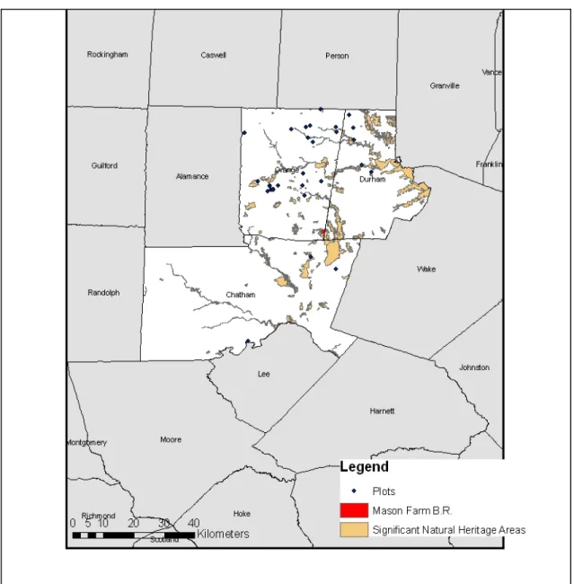
The field study was conducted on utility rights-of-way in Chatham, Durham, and
Orange Counties in the North Carolina Piedmont during the summer of 2008 (Figure 2.1). Many ROWs in this area are mown every two to 10 years, depending on which utility company is managing it (Duke Energy and Piedmont Electric Membership
climate, with an average temperature of 14° C, and an average rainfall of 122 cm (NOAA
Online Weather Data 2009).
A remnant ROW site is one that harbors native plants that we would expect to
find in open-canopied natural communities in the Piedmont. Consideration of a true
“remnant”—that is, an area that is essentially a much smaller representation of a plant
community that once stood at a much larger extent on that site—was of less concern in
this scenario than capturing an appropriate set of plant species occurrences. The focus lay
in finding ROW sites that, regardless of origin, still held a significant diversity and
dominance of native grasses, legumes, and Asteraceous plants. Sites were found by
exploring the rural roads of the study area and looking for assemblages of these kinds of
plants. Local ecologists and botanists also suggested a handful of sites to survey.
Quantitative data were collected on 31 sites determined as quality sites harboring
native heliophilic herbaceous species. These sites occurred on rural roadsides in Orange,
Durham, and Chatham Counties. Five criteria were used to choose sites:
1) Dominance of regionally native forbs and graminoids,
2) Presence of indicators suggested by botanists as “high quality”(e.g.,
Sorghastrum, Schizachyrium, Parthenium, Silphium, Eupatorium, and Baptisia)
3) Extent of the site (sufficient to include a 5 x 20m or 10 x 10m plot),
4) Occurrence within a 50 km radius of Chapel Hill, North Carolina, and
Figure 2.1 Plot locations in the local 3-county area are denoted by dark blue points. Significant Natural Heritage Areas are also featured on the map for reference.
Field methods
The Carolina Vegetation Survey (CVS) protocol was applied as the vegetation
sampling method (Peet, Wentworth, and White 1998). In addition to recording species
presence and cover, abiotic conditions were also documented. Botanical nomenclature
Twenty-nine 5m x 20m plots, and two 10m x 10m plots, were sampled, each
scenario using the CVS single-module protocol. Species cover and nested presence
values were recorded. Twenty-one environmental variables were measured at each plot.
Soil samples collected from the upper mineral horizons were sent to Brookside
Laboratories, Inc., New Knoxville, OH, for nutrient and texture analysis. Total cation
exchange capacity (TEC; milliequivalents /100g), pH, percent organic matter (OrgMa),
estimated nitrogen release (ENitR; lbs./acre), exchangeable cations (Ca, Mg, K, Na parts
per million), extractable micro-nutrients (B, Fe, Mn, Cu, Zn, Al ppm), soluble sulfur
(ppm), and extractable P (ppm) were all measured. Extractions were made using the
Mehlich III method (Mehlich 1984). Texture analysis was carried out using the
hydrometer method. In addition to measuring species abundance and edaphic conditions,
aspect, slope, and canopy openness were measured. Aspect and slope were extracted
from North Carolina Department of Transportation data resources with accuracy to 25 cm
(NCDOT 2007). To determine canopy openness, hemispheric photos were taken of the
canopy at each plot. The program Gap Light Analyzer (version 2.0; Frazer et al. 1999),
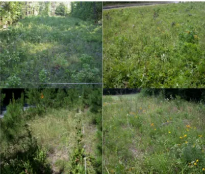
Figure 2.2 Some examples of ROW plots (Summer 2008).
Species data
Plants were identified to species when possible. However, if there was a lack of
critical floral parts, taxa were either lumped into lower resolution complexes of the same
genus (e.g., Solidago spp.) or treated as a distinct taxonomic unit identified to genus (e.g.,
Allium sp.). There were cases where multiple taxonomic units shared the same genus, but
were determined as distinct (e.g., Eupatorium sp. #1 and Eupatorium sp. #2). These
complexes served as the operational taxonomic units for the analysis.
The open-sourced platform for statistical computing, R (Version 2.10.1) was used
to perform all statistical analyses on the 31 roadside plots. To identify groups of roadside
cover class values found on those plots. A cluster analysis was also performed on species
absence data to determine if plot groups might relate differently using
presence-absence data only. Results of the presence-presence-absence cluster analysis were found not to be
different than those of the average species cover class cluster. Results were displayed
with a dendrogram (see Figure 2.3). The flexible beta method was used for clustering
(Lance and Williams 1966); McCune and Grace (2002) consider this method the most
compatible with community data. The flexible beta method generalizes multiple
agglomerative clustering algorithms into one, and the user can manipulate beta to view
how groups may shift with different criteria (Borcard et al. 2011). The beta values chosen
were β = -0.1, β = -0.25, β = -0.45, β = -0.65, and β = -0.85. A stopping rule was applied
subsequent to examining two different grouping scenarios for each of the cluster results
(10 total) and the results from an indicator species analysis (Dufrene and Legendre 1997)
on those grouping scenarios. The indicator value for each species was calculated by
combining the relative abundance and relative frequency of each species in each plot
group. The statistical significance for indicator values (p) was calculated using a Monte
Carlo test with 100,000 iterations. The best grouping scenario was chosen where the
number of indicators and strongest significance was obtained.
Species and environmental data
Ordination was used to display complex relationships among the roadside plots by
placing those objects along as few axes as possible to simplify relationships among
objects (McCune and Grace 2002). Nonmetric multidimensional scaling (NMDS) was
used on the species data, as it is an ordination method well suited to data that are
as appropriate for viewing species community data (Okansen 2011). Additionally, a
principal components analysis (PCA) was additionally performed on the environmental
data (Legendre and Legendre 1998). Biplots were produced for both ordinations to assess
the relationship of the environmental variables to the ordination axes. The environmental
data was transformed and standardized prior to the ordinations. For soil texture variables
(silt and sand), a log-ratio transformation was used (Lark and Bishop 2007) in which the
pair wise ratio of the percent composition was log-transfomed (silt.sand, clay.sand). For
aspect, a sine transformation was used. Each nutrient variable was log-scaled, except
aluminum (ppm) and iron (ppm), which displayed normal distributions and were scaled
to unit variance (Borcard et al. 2011). Clustered groups of plots are displayed as hulls in
the ordinations and are distinguishable by color.
2.3 Results
I recognized 236 taxonomic units on 31 sites. A complete table of species with
their group designation and indicator value is included in Appendix 2.1. Although there were woody species recorded, they did not reach breast height. Otherwise, grasses and
forbs dominated the sites. Included in the grand total of taxa were 13 exotic species (or
“introduced,” as designated by the USDA Plants Database). There were five operational
taxa whose native status remains unknown due to failure to identify to species level.
Species summaries are represented by the cluster analysis, indicator species analysis, and
non-metric multidimensional scaling. An environmental variable table of roadside plots is
presented in Appendix 2.2.
Although many plots retained their position on the dendrogram when beta was
varied, the shifting division of groups was more variable. A beta value of -0.25 with plots
split into four groups resulted in the best combination of indicator species number and
values. The dendrogram of this cluster scenario is displayed as Figure 2.3, with plot numbers colored according to their associated group. An additional cluster analysis of
Figure 2.3 Cluster dendrogram of species data from ROW plots. Plots are grouped by species cover data using flexible beta agglomerative clustering. A horizontal line represents the length at which group divisions were designated (n = 0.87).
Indicator species analysis
Indicator species analysis identified a total of 36 species as significant indicators.
Two of these indicators are exotics (5.5 %), and seven are woody species (19.4 %). The
tables below list indicator species by their associated plot groups from the cluster
analysis. The Monte Carlo test of significance was run with 100,000 iterations to
determine p-values and indicator values. There were 8 indicator species identified in
Group 1 with one of these indicators being a woody, exotic species. There were twelve
indicators identified in Group 2, two of which are exotics, and four of which are woody.
There were 13 indicators identified in Group 3, six of which are woody species. In Group
4 there were three indicators identified.
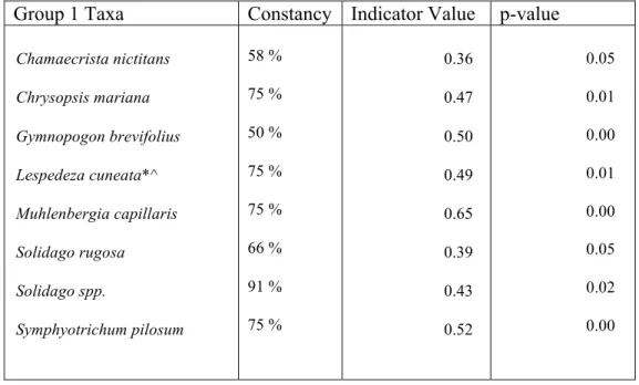
Table 2.1 List of indicator species for ROW group 1 determined by species cover. Constancy, Indicator Value, and Monte Carlo significance (p-value), are represented for each taxon. Woody species are denoted with a “^”, and exotic species are denoted with a “*”.
Group 1 Taxa Constancy Indicator Value p-value
Chamaecrista nictitans
Chrysopsis mariana
Gymnopogon brevifolius
Lespedeza cuneata*^
Muhlenbergia capillaris
Solidago rugosa
Solidago spp.
Symphyotrichum pilosum
58 %
75 %
50 %
75 %
75 %
66 %
91 %
75 %
0.36
0.47
0.50
0.49
0.65
0.39
0.43
0.52
0.05
0.01
0.00
0.01
0.00
0.05
0.02
Table 2.2 List of indicator species for ROW group 2 determined by species cover. Constancy, Indicator Value, and Monte Carlo significance (p-value), are represented for each taxon. Woody species are denoted with a “^”, and exotic species are denoted with a “*”.
Group 2 Taxa Constancy Indicator Value p-value
Aletris farinosa Apocynum cannibinum Asclepias variegata Coreopsis auriculata Desmodium strictum Festuca spp.* Fraxinus americana^ Liquidambar styraciflua^ Lonicera japonica*^ Oenothera fruticosa Potentilla canadensis Vaccinium pallidum^ 60 % 80 % 60 % 40 % 80 % 100 % 100 % 100% 100 % 80 % 100 % 100 % 0.51 0.47 0.60 0.40 0.40 0.70 0.58 0.38 0.39 0.40 0.41 0.64 0.01 0.02 0.00 0.02 0.03 0.00 0.00 0.01 0.05 0.04 0.00 0.00
Table 2.3 List of indicator species for ROW group 3 determined by species cover. Constancy, Indicator Value, and Monte Carlo significance (p-value), are represented for each taxon. Woody species are denoted with a “^”, and exotic species are denoted with a “*”.
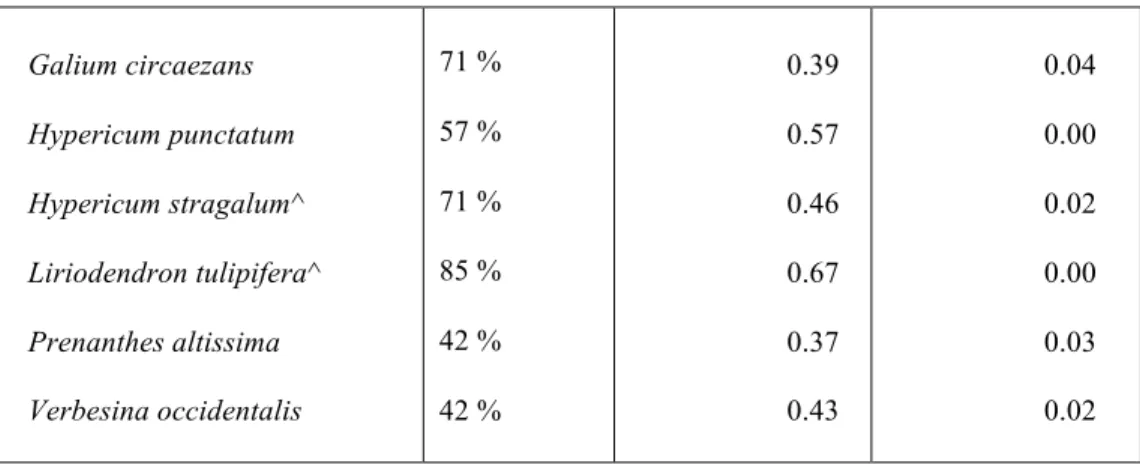
Group 3 Taxa Constancy Indicator Value p-value
Galium circaezans
Hypericum punctatum
Hypericum stragalum^
Liriodendron tulipifera^
Prenanthes altissima
Verbesina occidentalis
71 %
57 %
71 %
85 %
42 %
42 %
0.39
0.57
0.46
0.67
0.37
0.43
0.04
0.00
0.02
0.00
0.03
0.02
Table 2.4 List of indicator species for ROW group 4 determined by species cover. Constancy, Indicator Value, and Monte Carlo significance (p-value), are represented for each taxon. Woody species are denoted with a “^”, and exotic species are denoted with a “*”.
Group 4Taxa Constancy Indicator Value p-value
Tephrosia virginiana
Baptisia tinctoria
Silphium compositum
85 %
71 %
85 %
0.75
0.50
0.49
0.00031
0.01
0.01
Nonmetric multidimensional scaling
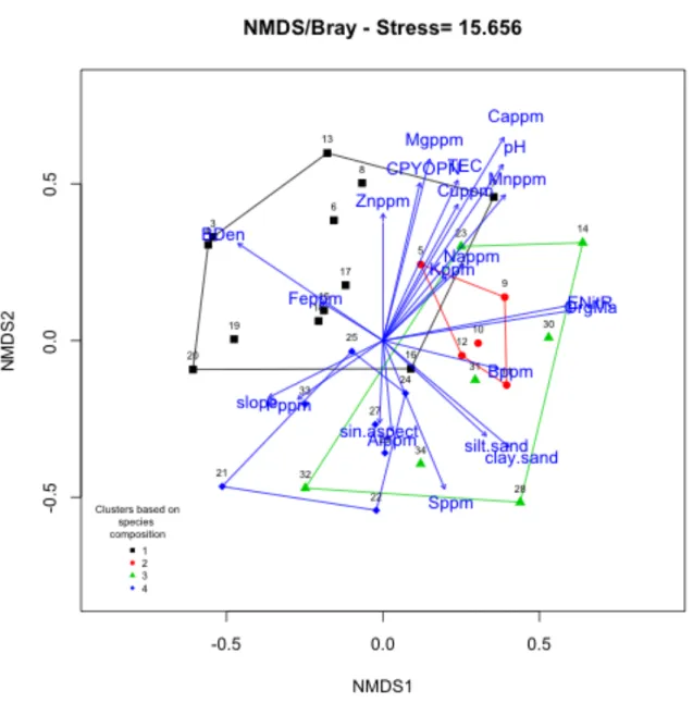
The non-metric multidimensional scaling ordination reveals that the four groups
that were defined with the cluster analysis display some overlap (Figure 2.4). A 3-dimensional scenario was chosen, and a view of the remaining two views of the
ordination reveals a similar level of overlap. Figures 2.4-2.6 are biplots of each view of the 3-dimensional ordination. Groups can be interpreted as sub-types of mostly native
vegetative communities found along roadsides.
Ordination-environment biplot
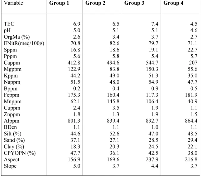
The biplot in Figure 2.4 displays environmental variables that may be driving the roadside plot groups. It appears that, in this graphical scenario, pH (r2 = 0.52), Cappm (r2
the most significant drivers of the ordination. Group 1 is likely driven by soil texture
(BDen and low silt/sand), whereas Groups 2 and 4 appear to be distinguished mostly by
pH and nutrients (e.g., Cappm and Mnppm), and perhaps canopy openness (CPYOPN).
Group 3, on the other hand, looks to be driven by a combination of the texture and
nutrient variables, as well as estimated nitrogen release (ENitR), organic matter (OrgMa),
and slope. Table 2.5 displays the mean values of each pre-transformed variable for each plot group.
Table 2.5 Mean value of each environmental variable for each ROW plot group, prior to data transformation.
Variable Group 1 Group 2 Group 3 Group 4
Figure 2.6 NMDS biplot of ROW plot groups displaying axes 2 and 3.
Principal components analysis
The PCA (Figure 2.7) shows the roadside plots ordinated by their environmental variables. The color-coded hulls represent the groups that were determined by the cluster
analysis. The distinctions between the cluster groups are weaker than that shown on the
NMDS ordination. Principal axis 2 appears to be most driven by texture (BDen, silt.sand
and perhaps slightly by pH. Group overlap is fairly substantial and is also evident in the
environmental summary table (Appendix 2.2).
Figure 2.7 Principal components analysis, with biplot vectors and roadside plot position from environmental data. The color scheme originates from the cluster groups designated by species cover data.
2.4 Discussion
factor, as well as pH, calcium, and magnesium. The results from the NMDS and PCA
biplot were generally consistent in this regard. Group divisions appear less distinct in the
PCA, as plots tend to fall more gradually along an environmental gradient.
The ROW community sub-types or “Groups” do not strongly adhere to the
documented open plant communities of the southeastern Piedmont (Table 1.2). I evaluated this by looking for matches of the dominant species of these natural
communities with the dominant species (indicators) from the ROW groups. There are
certainly floristic similarities amongst ROW groups, but the ROW group vegetation is
assembled in patterns not quite equivalent to those of the documented natural
communities. Group 1, which included the most open plots on average (% CPYOPN),
consists of herbaceous vegetation also important in a few documented communities from
Table 1.2. These include Piedmont Granitic White Oak-Black Oak Savanna
(CEGL003722) and Piedmont Chestnut Oak-Blackjack Oak Woodland (CEGL003708).
Examples of taxa overlap among Group 1 and the natural communities include
Desmodium ciliare, Gelsemium sempervirens, and Solidago rugosa.
Group 2 consists of somewhat high-moisture plots, and important indicators
include Aletris farinosa, Oenothera fruticosa, and Potentilla canadensis. In terms of
similarities to natural community types, Group 2 consists of components present in
several of the documented communities, including some with both acidic and
circumneutral affinities.
Group 3 is the most nutrient-rich. However, this is not greatly apparent given the
indicators of the group. For example, Anemone virginiana, Hypericum stragalum, and
significant botanical components in Group 3 present in the Piedmont Diabase White Oak
Woodland (CEGL003721), Southern Piedmont Basic Rocky Woodland (CEGL004443),
and Diabase Glade (CEGL004276) types. A few examples include Clematis ochroleuca
and Sorghastrum nutans, and Echinacea laevigata.
Group 4 can be characterized as plots that were on acidic, nutrient-poor sites. This
group exhibits the least variability in environmental measurements. The taxa on these
sites are also found commonly on the Piedmont Acidic Glades (CEGL004910) and
Piedmont Chestnut Oak-Blackjack Oak Woodland (CEGL003708) types. Among these
species are Danthonia spicata, Tephrosia virginiana, and Silphium compositum.
These data suggest that these roadside “communities” are their own collection of
ecological entities. One feature of these communities that may help explain their apparent
uniqueness is that they serve as natural and somewhat compressed corridors for species
dispersal in an increasingly fragmented landscape. Rights of way, where not already
altered due to exotic species dominance, support opportunistic species that continue to
thrive in a variety of environmental contexts.
The corridor concept of metapopulations is described in detail by Ouborg and
Erikkson (2004). In this context, roadside corridors provide an avenue for savanna
vegetation dispersal. Historically, savanna communities were allegedly more extensive
where they occurred (Barden 1997), and were not interrupted by frequent constructed or
exotic plant-dominated landscapes. Given the current disjunct nature of open community
types in the Piedmont, conservation biologists might infer that dispersal corridors are
Species were often present in more than one group, as represented by the
constancy values in Appendix 2.3 The overlapping nature of the taxa, in terms of their roadside group affinities, may reflect a more generalist nature of the taxa on the sites
sampled. The wide reach of many species will leave managers wishing to use the species
lists with a great deal of flexibility on applying appropriate species assemblages in
restoration. This flexibility could be interpreted as a weakness in the appropriateness of
the use of these species lists in savanna rehabilitation projects. However, this high level
of overlap may ultimately reflect that heliophilic plants are highly adapted to a wide
range of conditions in the Piedmont, as long as management ensures open canopies.
Additionally, there are species in the indicator tables (Table 2.1 – 2.4) with high fidelity to groups, and these should be prioritized in the application of species assemblages to
their preferred environmental habitats (in terms of edaphic variables) in local
rehabilitation studies or projects.
Ultimately, the use of these species lists for restoration appears to be appropriate,
as long as environmental attributes on the restoration sites are used as the determinant
factors. Further study is needed to capture a more comprehensive picture of roadside
native vegetation, especially in a larger geographic region. It would be interesting to
know whether indicators found in this study are similar to those that might be derived
from other studies in different areas of the Piedmont.
There is an ongoing effort by conservation biologists in the Piedmont to push for
management of roadsides and rights-of-way to conserve what is sometimes a high-quality
example of native vegetation. Duke Energy, a local rights-of-way manager, touts the
Corporation 2011). This is a highly debatable claim, as they have no evidence to show
that the effects on soil and surface runoff are negligible. Additionally, they do not
mention native plant conservation. The Federal Highway Administration is seemingly
taking a different approach, promoting the value of native vegetation to roadsides on their
website (Harper-Lore 2010). Here, the author goes into great detail regarding the use of
native plants as on the roadsides of federal highways. The amount of baseline information
is quite extensive and suggests that management include invasive species control,
supporting faunal habitat (e.g., butterflies and small mammals), erosion control, and
native wetland value in pollution filtering.
This study is largely preliminary in the establishment of Piedmont savanna
vegetation lists, and expanding it to incorporate a larger area might help us understand
the variability of the Piedmont savanna throughout its range. However, this study does
provide lists that can certainly be useful for savanna restoration within a limited range.
As such, conserving the suite of plants found on roadsides and rights-of-way is an
extremely important conservation objective in the southeastern Piedmont. Restoration of
savanna and other open communities that support the species found on these often
artificial sites is critical in the context of the somewhat whimsical management of rural
sites where they currently thrive. Additionally, if roadsides and rights-of-way are viewed
as a valuable source of seeds, dispersal corridors, and habitat for floral and faunal species
CHAPTER 3: THE APPLICABILITY OF RIGHTS-OF-WAY VEGETATION AS REFERENCE DATA FOR SAVANNA RESTORATION IN THE NORTH
CAROLINA PIEDMONT
3.1 Introduction
At the Mason Farm Biological Reserve (Mason Farm) of the North Carolina
Botanical Garden in Chapel Hill, NC (University of North Carolina at Chapel Hill), the
upland oak-hickory forests show signs of fire-suppression, as the canopy is nearly closed
and the ground layer vegetation is sparse. A portion of these uplands is the focus of an
effort to restore savanna-like conditions that are thought to have been present here, at
least within the past two centuries. Although the exact character of the savanna-like
conditions on uplands at Mason Farm are largely unknown, the canopies of upland forests
were likely more open and supported a ground layer with heliophilic, savanna herbs
(North Carolina Botanical Garden Staff 2006). Thus far, managers have implemented
prescribed fires on parts of the uplands to open up the understory. Adjacent to these now
closed-canopy upland forests are also old agricultural fields that are currently
fire-managed and now support a suite of native heliophilic plant species. There is much
interest in reestablishing a ground layer of native forbs and grasses in both the future
open woodland and old fields, which will involve actively sowing seeds or planting plugs
of a prescribed mixture of such plants.
As discussed in the first chapter, many ground layer plant species that occur in
documented natural communities with more open canopies in the Piedmont (i.e., open