This may be the author’s version of a work that was submitted/accepted for publication in the following source:
Li, Huan, Wu, Yuzhe, Huang, Xianjin,Sloan, Mellini, &Skitmore, Martin (2017)
Spatial-temporal evolution and classification of marginalization of culti-vated land in the process of urbanization.
Habitat International,61, pp. 1-8.
This file was downloaded from: https://eprints.qut.edu.au/102816/
c
Consult author(s) regarding copyright matters
This work is covered by copyright. Unless the document is being made available under a Creative Commons Licence, you must assume that re-use is limited to personal use and that permission from the copyright owner must be obtained for all other uses. If the docu-ment is available under a Creative Commons License (or other specified license) then refer to the Licence for details of permitted re-use. It is a condition of access that users recog-nise and abide by the legal requirements associated with these rights. If you believe that this work infringes copyright please provide details by email to [email protected]
Notice:Please note that this document may not be the Version of Record (i.e. published version) of the work. Author manuscript versions (as Sub-mitted for peer review or as Accepted for publication after peer review) can be identified by an absence of publisher branding and/or typeset appear-ance. If there is any doubt, please refer to the published source.
Spatial-Temporal Evolution and Classification of Marginalization of
Cultivated Land in the Process of Urbanization
Huan Li a,b, Yuzhe Wu a*, Xianjin Huang c, **, Mellini Sloan d, Martin Skitmore d
a Department of Land Management, Zhejiang University, Hangzhou 310058, China b Department of Public Policy, City University Hong Kong, Hong Kong
c Geographic and Oceanographic Sciences School, Nanjing University, Nanjing 210093, China d School of Civil Engineering and Built Environment, Queensland University of Technology,
Brisbane Q 4001, Australia
* Corresponding author - [email protected] ** Corresponding author - [email protected]
Abstract: Marginalization of cultivated land, resulting from rapid urbanization, exists as an important form of land use change, and represents a new research direction in land-use and land-cover change (LUCC). This article proposes a classification of such marginalization on the basis of elasticity of input and income, categorizing marginalization of cultivated land as either policy-induced (PIM), nature-induced (NIM) or economy-induced (EIM) marginalization. These classifications are further explored as either positive or negative marginalization, depending on whether the land is transformed from or into cultivated land. This innovative framework is applied to analyses of marginalization in Lianjiang County, located in southeastern coastal China. This research analyzes characteristics of spatial-temporal evolution of categories of marginalization of cultivated land using 3D kernel density methods. Significant findings point to spatial-temporal processes and driving forces of marginalization, including: (1) Concentrations of positive (P-PIM) and negative (N-PIM) policy-induced marginalization both occur and agglomerate in separate spaces, with the former mainly in the southeastern portion of the county and the latter in the northwest. (2) By contrast, patterns of positive (P-NIM) and negative (N-NIM) nature-induced marginalization complement each other in space - N-NIM tends to be more discrete in areas with P-NIM aggregations, and vice versa. (3) Finally, areas with aggregations of positive (P-EIM) and negative (N-EIM) economy-induced marginalization overlap. The research suggests that relevant land use policies should be formulated in response to these characteristics of cultivated land marginalization so as to address marginalization of cultivated land, especially as associated with rapid urbanization.
Keywords: marginalization; cultivated land; elasticity; spatial-temporal; urbanization; kernel density
1 Introduction
producers and their land commenced in England with the enclosure movement of the 16th and 17th centuries (Neeson, 1994), with of marginalization of cultivated lands following. The end of the second industrial revolution in the 19th century marked a gradual weakening of the importance of agricultural production to national economic growth, with its formerly dominant position replaced by industry and commerce. As part of this shift, large amounts of cultivated land were withdrawn from grain production and permanently converted to industrial and commercial uses (Wu et al., 2014). Contemporary patterns of rapid urbanization and population growth, in tandem with widespread destruction of cultivated land and declines in the rural labor force, elevate problems of marginalization of cultivated land in developing countries among academics worldwide.
As a developing country with a large population and cultivated land under threat from rapid urbanization, China faces a number of challenges to its food security. Aside from urbanization, other factors, including Chinese farmers’ unwillingness to participate in food production, seasonal and permanent abandonment of cultivated land (Li et al., 2015), and acceleration of non-agriculturalization of cultivated land pose serious threats to national food security. Further, these shifts undermine ecological balances, strongly impact upon China’s agricultural sustainable development, and even shrink the foundation for social stability (Zhang et al., 2009). In 2014, China’s per capita arable area was only about one third of the world average. Globally, China’s cultivated land accounts for 8.69% of the total area of cultivated land, while needing to feed 18.86% of the world’s population (Grădinaru et al., 2015; Lyle et al., 2015). Forecasts indicate that China’s population will peak in 2030 (Wu et al., 2016), however its cultivated land continues to decrease. As such, addressing the marginalization of cultivated land is central to resolving problems of food security and agricultural productivity, as well as ensuring futures for farmers within society.
Previous research on the marginalization of cultivated land often does not approach the problem at a theoretical level, with studies relying on varying methodology and occurring in relatively scattered locations (Brouwer et al., 2008; Kang et al., 2013). Further, there are deficiencies in definitions of marginalization, and acknowledged opportunities for improvement and innovation in research method and outcomes in this area (Milbrandt et al., 2014; Zhang et al., 2012). This research endeavours to remedy two problems: the first being a lack of a scientific and systematic classification standard for types of marginalization of cultivated land, grounded in an appropriate theoretical basis; and a deficit of quantitative research and spatial-temporal analyses of the marginalization of cultivated land.
of the different types of cultivated land marginalization, identification of the manifest forms of marginalization, and specific reference to various marginal lands using 3D kernel density analysis. Relying upon review of such spatial-temporal evolution of cultivated land marginalization, the paper provides theoretically grounded policy recommendations for improvement of the sustainable utilization of cultivated land, towards guaranteeing national food security and maintaining social stability in the face of rapid urbanization.
2 Theoretical framework and methodology
2.1 Theoretical exploration of research on marginalization of cultivated land 2.1.1 Definition and classification of marginalization of cultivated land
Marginalization of cultivated land exists as the processes and patterns of continuously decreasing net income associated with cultivated land utilization. As marginalization occurs, gains associated with production gradually decline so as to be insufficient to cover costs (Liu and Li, 2006), which can also be expressed as food economic production capacity of less than or equal to 0 (Bao, 2014). The extent of responsiveness of income with change in the price is not always the same. The income for a grain product can be elastic or inelastic, depending on the rate of change in the income with respect to change in input of a grain product. This research has classified the marginalization of cultivated land into perfectly inelastic, lack of elastic and elastic based on the elastic theory of input and income. As there has a battery of factors (e.g., political competition among local governments, central government controls, local endowments) that can affect the elasticity, the types of elastic and lack of elasticity are in the form of curves, rather than straight line.
(1) An income-input elasticity of zero (e = 0) represents perfectly inelastic (Figure 1), wherein variable inputs do not result in changes in income (Sun et al., 2016). Under such conditions, proceeds from food production will remain unchanged or may reduce to nil even if there is an increase in various production factors considered as an increase in investment (Sabatelli, 2016). In other words, input of grain production factors will not affect the income of grain production in this land parcel or the food production income there will be zero. As a consequence of urban expansion policies, vast acreages of cultivated land are turned to construction land and are
R
e=0
c
removed from grain crop production, which means the inelasticity of income-input. When e=0, marginalization of cultivated land is described as policy-induced marginalization (PIM).
(2) Where the absolute value of income-input elasticity is less than one (| e | < 1), income is described as lack of elasticity. As Figure 2 illustrates, increases in incremental input are not met by increases in incremental income of similar magnitude. Although inputs of production factors have been increased, they still have limited contribution to the production of cultivated land. For instance, economic production capacity of cultivated land will always be limited by gradient, soil conditions and water sources. Consequently, the income-input of this land is inelastic; resulting in
either further abandonment of the land or its return to forestry. Either way it is no longer farmed for food production. Marginalization of cultivated land is referred to as nature-induced marginalization (NIM) if | e |<1.
(3) When the absolute value of income-input elasticity exceeds one (| e | > 1), variable inputs result in amplified changes in income, and income is said to be elastic (Sun et al., 2016). For example, a 1% shift in inputs results in changes of income in excess of 1% (Sabatelli, 2016). As seen in Figure 3, a small increase in input s from c2 to c1 results in a relatively large increase in
income from R2 to R1. Increasing inputs of production factors can make tremendous contribution
to economic production of cultivated land. For instance, with only a small investment, high quality cultivated land produces considerable grain yield. However, when high quality cultivated land is used to grow other food and non-food crops (e.g., vegetables, fruits, flowers, plants, medicinal materials), the net economic income may far surpass that associated with food. This economic
R
| e |<1
c
c
1c
2R1
R2
Figure 2 Lack of elasticity
R
| e |>1
c
c
1c
2R2 R1
advantage may drive some cultivated land to be converted to other farmland types, removing it from food production. Under conditions where | e |>1, marginalization of cultivated land can be said to be economy-induced marginalization (EIM).
2.1.2 Internal logic relations and spatial manifestation forms of marginalization of cultivated land
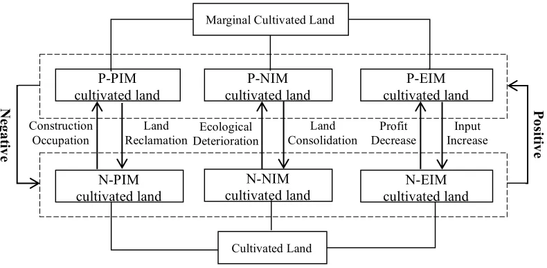
Each form of marginalization can be further classified as either positive or negative, with positive marginalization removing cultivated land from grain production, and negative marginalization returning previously cultivated land to grain production. When cultivated land undergoes urban development, the land is removed from grain production and its economic grain production capacity goes to zero. In this instance, the physical essence of the land has changed as a result of positive policy-induced marginalization (P-PIM). Where P-PIM lands are later reclaimed for grain production, negative policy-induced-marginalization (N-PIM) occurs. Positive nature-induced marginalization (P-NIM) describes the abandonment or return to non-grain production (e.g., silviculture) of crop lands as a consequence of limited economic grain production capacity attributed to changed conditions (e.g., gradient, soil conditions, water resource availability, or temperature) which may be associated with anthropogenic activities and or climactic variation. When interventions (e.g., terracing, fertilization, irrigation) bring about improvements to land conditions, these lands may be returned to production and are considered to have undergone negative nature-induced marginalization (N-NIM). Finally, increases in capital inflows into non-grain agricultural production sectors can result in positive economy-induced marginalization (P-EIM), wherein land is converted to crops with stronger economic production capacity. Under-investment in labor, capital and technology can also result in P-EIM of food crop lands. Similarly, increases in investments can improve the economic production capacity of P-EIM land, transforming it into N-EIM land.
Figure 4 Internal Logic Relations among Different Types of Marginalization of Cultivated Land
2.2 Spatial-temporal analysis methodology
Based on the classification of marginalization of cultivated land, we will apply the 3D kernel density surface method to do spatial-temporal analysis. Identification of spatial-temporal patterns of marginalization of cultivated land requires both estimation of its magnitude and observation of patterns of clustering. Towards that end, locations of marginalized cultivated lands were analyzed to calculate a standard distance (SD), or degree of dispersion of these locations across the area of study relative to their geometric mean center. ArcGIS’s search radius (band with) algorithm, which is included in the Spatial Analyst toolbox, utilizes the standard distance in tandem with the calculated median distance (Dm) from the geometric center of the locations and the number of
occurrences (n) of marginalized use to calculate a search radius (or bandwidth) (Formula 1). A value of 30,000 kilometers (km) was determined as the search radius. A density estimation method (Gatrell, 1994) as represented in Formula 2 was then followed by a nonparametric kernel estimation method (Silverman, 1986) as calculated in Formula 3. ℜ represents the study area, x
represents a general location in ℜ and x1, x2…. xn are the locations of water area change, λ(x)
represents the density at x. k(.) is the kernel function, the parameter h > 0 is the bandwidth determining the amount of smoothing, wi is a weighing factor, and δh(x) is an edge correction
factor (Cressie, 1993). The quartic kernel function (Formula 3) described in Silverman (1986) was used for generating the kernel density surface (KDS) for each period. Finally, λ(x) was chosen to
be the baseline height, with KDS computed and displayed in ArcScene for 3D visualization with a 50-meter pixel resolution (Xu et al., 2016).
𝑆𝑒𝑎𝑟𝑐ℎ 𝑅𝑎𝑑𝑖𝑢𝑠 = 0.9×𝑚𝑖𝑛 𝑆𝐷, 78 (:)6 ×𝐷< ×𝑛=>.:, (1)
𝜆@ 𝒙 =B6
C D
EF
@G𝑘
𝒙=𝒙F
@ I
JK6 , 𝒙 ∈ 𝕽, (2)
Cultivated Land P-PIM cultivated land N-PIM cultivated land N-NIM
cultivated land cultivated land N-EIM P-NIM
cultivated land
P-EIM cultivated land
Marginal Cultivated Land
Construction Occupation
Land
Reclamation Deterioration Ecological
Land
Consolidation Decrease Profit Increase Input
𝑘 𝑥 = 3𝜋=6 1 − 𝑥S𝑥 : 𝑖𝑓𝑥S𝑥 ≤ 1
0 𝑜𝑡ℎ𝑒𝑟𝑤𝑖𝑠𝑒 (3)
3. Research area and data sources
Urbanization in China increased in speed following the initiation of the reform and opening policy. By the end of 2015, 56% of the total population lived in urban areas, a dramatic increase from 26% in 1990. China’s southeastern coastal region, as shown in Figure 5, is among the country’s most developed area. Much of the region’s high-quality cultivated land has been converted for urban use, withdrawing it from production of grain, in the process of rapid urbanization. Recent economic development in the region has diversified employment opportunities, and the opportunity cost of non-agricultural employment is extremely low, tempting farmers to consider exiting agricultural employment. Further, young adults within the rural portions of the region do not have much enthusiasm to engage in grain production, such that they leave land uncultivated(Zhong et al., 2011). These are all incentives for the marginalization of cultivated land.
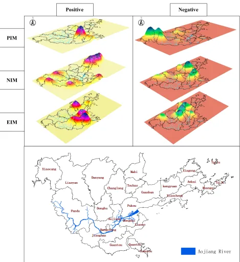
Figure 5 Geographical Location of Lianjiang County
This research examines Lianjiang remote sensing data acquired in 1992, and land use data in shapefile format in 2012 to facilitate examination of marginalization of cultivated land. According to the land use types in 2012 land use data, we classified the 1992 remote sensing data into six land use types: cultivated land, orchards, woodland, grassland, construction land and unused land, which, through further calculation, could obtain the areas of these six land use types. The 2012 data, provided by the Land and Resources Bureau of Lianjiang County, is used as a representation of current land use.
4 Research results
4.1 Characteristics of spatial-temporal evolution of Policy-Induced Marginalization (PIM) (1) Spatial-temporal evolution of Positive Policy-Induced Marginalization (P-PIM)
Comparative analyses of the land use data for 1992 and 2012 indicates that Lianjiang County has 1,530.12 ha of P-PIM cultivated land, or land that has been transformed from cultivation into urbanized use. This transformation confirms other observations of development trends in the county. As Figure 6 shows, P-PIM cultivated land is highly concentrated in the central town of
China Fujian Province
Lianjiang County
Fengcheng, with some satellite development occurring in other towns as described below. This pattern matches expectations associated with development direction in China, with initial focus on key towns with the expectation that such development will then drive subsequent development of other surrounding towns.
The large, pronounced bulge in the 3D kernel density as mapped in Figure 6 corresponds to the location of the town of Fengcheng, demarcating a concentration of cultivated land converted to urbanized use. The magnitude of the bulge indicates that the town has the highest concentration of P-PIM cultivated land in the county. Urbanization in and around Fencheng has expanded its administrative region from 300 to 800 ha between 1992 and 2012, a 270% increase. This is not surprising as Fengcheng exists as both the seat of government and the political, economic and cultural center of the county. Recent, rapid development along the banks of the Aojiang River has resulted in widespread conversion of cultivated land to urban use along both sides of the river. Four smaller bulges can also be seen in the mapping of P-PIM in the county – they are roughly distributed in a north-south axis associated with the towns of Guantou, Mabi, and Pukou. The speed of the economic development of these three towns is in excess of that for the county as a whole. P-PIM within these areas covers over 100 ha.
(2) Spatial-temporal evolution of Negative Policy-Induced Marginalization (N-PIM)
Whereas P-PIM is concentrated in the mid-section of the county, N-PIM (309.12 ha) occurs primarily in the northwest of Lianjiang County, with a comparatively small concentration of N-PIM cultivated land in the central town of Changlong. Mapping of the 3D kernel density of N-PIM cultivated land (Figure 6) indicates three pronounced bulges located in the northwestern towns of Xiaocang and Liaoyan. Xiaocang has a greater concentration of N-PIM cultivated land (~100 ha) than any other town in the county, and is home to one-third of its total N-PIM cultivated land area.
Note: the height of bulge represents the density of marginalization and all maps are rotated to the same extent Figure 6 Comparison of 3D kernel density among different types of marginalization
4.2 Characteristics of spatial-temporal evolution of Nature-Induced Marginalization (NIM) (1) Spatial-temporal evolution of Positive Nature-Induced Marginalization (P-NIM)
There are 395.11 ha of P-NIM cultivated land in Lianjiang County. The generation of P-NIM cultivated land is based on the local natural environment characteristics and attributed to the anabatic influence of human activities. The cultivated land salinization is serious in east coastal area of Lianjiang County due to the marine corrosion especially on partial islands and the affected cultivated land thereby covers an area of 55.23 ha. The cultivated land is always subject to a low
Positive Negative
PIM
NIM
EIM
grain yield and most of them are distributed in the islands far away from the mainland. After the island residents’ moving and dwelling from the islands to the inland of Lianjiang County, some of the local cultivated land has been abandoned to form the P-NIM cultivated land.
As seen in the mapped 3D kernel density of P-NIM (Figure 6), there are five obvious bulges, with extreme aggregation occurring among the coastal towns of Huangqi, Tailu and Ankai. Land salinization is a significant issue in these areas, reducing suitability for crops. Additionally, out migration of the local population from this part of the county has resulted in dereliction of use of cultivated lands. In the islands of Ankai Town in particular, 5.2 ha of cultivated land can be classified as P-NIM cultivated land, constituting over 25% of the total area of the islands. The magnitude of the 3D kernel density bulges can be attributed to the combination of the relatively small area along with the number of aggregated plots subject to P-NIM.
P-NIM cultivated land also occurs in aggregations of lesser magnitude in the western portion of Lianjiang County. Land cultivation is primarily concentrated in the relative lowlands of this otherwise mountainous part of the county. Steep gradients in this area make it unsuitable for large-scale mechanized farming, such that farmers may decide to abandon cultivation. Further, human activities (e.g., mining, dredging and earth cutting for brick-making) spur anthropogenically induced “natural” disasters such as landslides and debris flows, which add to the large area of P-NIM cultivated land in the western part of the county.
(2) Spatial-temporal evolution of Negative Nature-Induced Marginalization (N-NIM)
Lianjiang County has 209.22 ha of N-NIM cultivated land. Lianjiang County’s land consolidation planning indicates that by 2020 renovated farmland shall increase to 8,650.08 ha, with cultivated land potential increased by 605.51 ha, yielding an average potential coefficient of cultivated land increase of 7%. Under the plan, high-level farmland construction will covers an area of 5,733.33 ha. Most of the high-level farmland construction projects are located in the middle portion of the county. In this area, environmental factors which previously made the land unsuitable for cultivation have been addressed, improving what was otherwise abandoned or unused lands into high-level farmlands.
Other bulges are mainly aggregated in the northern portion of the county, where land reclamation projects of varying degree and scope are being undertaken. An obvious bulge at the town of Dongdai in the eastern portion of Lianjiang County represents a small (4.93 ha) area of N-NIM cultivated land which is highly concentrated with a higher aggregation degree. It follows that the characteristics of spatial distribution of N-NIM cultivated land in Lianjiang County are closely related to local farmland renovation, especially the implementation of high-level farmland construction projects. Areas with more concentrated high-level farmland construction projects will have more obvious N-NIM, as will coastal areas of tideland reclamation.
4.3 Characteristics of spatial-temporal evolution of Economic-Induced Marginalization (EIM)
(1) Spatial-temporal evolution of Positive Economic-Induced Marginalization (P-EIM)
Spatial distribution of P-EIM cultivated land (459.12 ha) within Lianjiang County is closely related to economic development and urbanization patterns within the county. Expansion of development along the banks of Aojiang River has rapidly increased the economic benefit to be gained from nonfood production of otherwise high quality cultivated land. Urban residents’ desires for increased living standards and transportation conditions exacerbate the problem, with shifts of agricultural production away from food. For example, the economic benefit to be gained from flower and fruit cultivation is much higher than that associated with grain crops planted on the same land. According to the investigation launched in Lianjiang country, the annual net income of grain farmers is RMB10,000 Yuan, while flower and fruit crops yield incomes in excess of RMB100,000 Yuan. These trends in profit cause capital to flow among different agricultural production sectors, and also across multiple industries. This movement leads to a relative reduction in capital allocated for food production and land use consequent insufficient utilization of high quality cultivated land for food production, and an overall decrease in grain yield.
unsuitability for large-scale mechanized production. Distance from urban centers and availability of transport further reduces this area’s suitability for these cash crops. Farmers who wish to sell fruits and flowers planted in this region would need to walk for several hours to reach the local market, prohibiting large-scale transactions.
(2) Spatial-temporal evolution of Negative Economic-Induced Marginalization (N-EIM)
There are 634.12 ha of N-EIM cultivated land in Lianjiang County, predominantly in the county’s north-central region and closely associated with the development of high-level basic farmland construction. This region has low relief with large areas of contiguous and agglomerated cultivated lands. Some scattered orchards, woodland, vegetable greenhouses have been renovated into basic farmlands, expanding the original contiguous cultivated land to meet requirements for high-level farmland construction. High-level farmland construction in the town of Liaoyan covers an area of 354.79 ha, incorporating an increase of 44.09 ha, while similar development in the town of Danyang Town encompasses 383.76 ha with 39.80 ha of newly increased cultivated land.
As seen from 3D kernel density of N-EIM (Figure 6), there are three comparatively obvious bulges and three slight bulges mainly assembled in the towns of Toubao and Danyang in the north of the county. These towns have an urgent need for increased cultivated land. In Toubao, rapid economic development requires transformation of cultivated land to construction land, which results in an urgent need to supplement cultivated lands through the conversion of forest and orchardsorchards. By contrast, Danyang has a relatively large amount of cultivated land and is undergoing relatively slower economic development. These conditions prompt conversion of orchards and woodland with weak economic production capacity into the cultivated land. The town of Pandu, located in western Lianjiang County, possesses the highest amount of N-EIM cultivated land, but it has no obvious bulges. Research suggests that this may be attributed to the scattered distribution of plots used for planting fruits, vegetables and tea in this hilly and mountainous area. Therefore, according to the 3D kernel density analysis, the western part of the county does not present an obvious phenomenon of N-PIM cultivated land aggregation.
5 Conclusion and discussion
In classifying China’s cultivated land marginalization into policy-induced (PIM), nature-induced (NIM) and economy-induced (EIM) based on theories of income-input elasticity and the subsequent spatial-temporal analyses, this paper addresses a number of previous issues in this area of research. From this, and the empirical research findings of the study, the following policy suggestions are offered to effectively minimize cultivated land marginalization:
cultivated land and prevent the loss of high quality cultivated land. This could be furthered by improving the intensity of urban construction land, strengthening the reconstruction of the old city, raising the population carrying capacity and economic creativity of the old city and strictly controlling the amount of newly increased construction land. The redevelopment of village and town construction land and improving the intensity of rural construction land should also help reduce further loss. There are currently many “hollow villages” in China where the rural construction land is underutilized, which suggests that reclamation of rural construction land will be an effective way of increasing the amount of cultivated land, while the reclamation of village and town construction land would also help facilitate the contiguous scale of cultivated land management. Moreover, there needs to be an increase in soil fattening and a stable improvement in cultivated land quality by land reclamation as a means to reducing physical marginalization.
(2) Efforts need to be directed towards the scientific development of farmland renovation practices, and in the recruitment and retention of additional labor force for agricultural production to resolve nature-induced marginalization of cultivated land. Measures also need to be taken to bring about a comprehensive improvement in the water, farmland, roads, woods and villages in rural areas and practically increase the effective area of rural cultivated land, improve cultivated land quality and increase its utilization by farmland renovation, including the consolidation of scattered plots to better adjust farmland structure; soil amelioration to improve the cultivated land quality; reclamation of damaged land and waste land; terrace building in mountainous and hilly land areas and remediation of waters for aquaculture; reclamation of decertified and salinized land to recover its fertility; vitalization of stocks and cleaning up idle land. The agricultural production workforce also need to be guaranteed, especially in rural areas with a relatively poor natural environment, where there is insufficient agricultural labor force for land reclamation and food production as, whenever there is a decline in the labor force of these areas, natural marginalization will most likely soon appear.
(3) Finally, agricultural subsidy needs to be enhanced and farmers’ income associated with grain production assured to minimize the economic marginalization of cultivated land and provide sufficient motivation for the farmers in its effective utilization, improvement in quality and increased agricultural output and intensity of farmland use. The current agricultural subsidy policy being mainly based on the area of farmland contracted by the farmers, needs to take into the utilization of land into consideration, including the cultivated land's production efficiency, sown area, plantation structure and multiple crop index to increase the farmers’ grain-growing area and alleviation of cultivated land marginalization.
Acknowledge
References
Bao, H. X., 2014, Volatility clustering in land markets, Property Management32(5):378 - 385.
Brouwer, F., Rheenen, T. V., Dhillion, S. S., 2008, Sustainable Land Management: Strategies to Cope with the Marginalisation of Agriculture, Edward Elgar, Cheltenham.
Chen, J., 2014, Sustainable utilization of cultivated land of lianjiang county, Anhui Agricultural Science Bulletin (05):68-69.
Cressie, N. A. C., 1993, Statistics for spatial data, in: Wiley series in probability and mathematical statistics Applied probability and statistics, Wiley, New York ; Chichester, pp. xx, 900 p. Deng, X., Huang, J., Rozelle, S., Uchida, E., 2006, Cultivated land conversion and potential
agricultural productivity in China, Land Use Policy23(4):372-384.
Gatrell, A., 1994, Density estimation and the visualization of point patterns, Wiley, New York.
Grădinaru, S. R., Iojă, C. I., Onose, D. A., Gavrilidis, A. A., Pătru-Stupariu, I., Kienast, F., Hersperger, A. M., 2015, Land abandonment as a precursor of built-up development at the sprawling periphery of former socialist cities, Ecological Indicators57(0):305-313.
Kang, S., Post, W., Wang, D., Nichols, J., Bandaru, V., West, T., 2013, Hierarchical marginal land assessment for land use planning, Land Use Policy30(1):106-113.
Li, H., Huang, X., Kwan, M.-P., Bao, H. X. H., Jefferson, S., 2015, Changes in farmers’ welfare from land requisition in the process of rapid urbanization, Land Use Policy42:635-641.
Liu, C., Li, X., 2006, Regional Differences in the Changes of the Agricultural Land Use in China during 1980-2002, Acta Geographica Sinica61(2):139-145.
Lyle, G., Bryan, B. A., Ostendorf, B., 2015, Identifying the spatial and temporal variability of economic opportunity costs to promote the adoption of alternative land uses in grain growing agricultural areas: An Australian example, Journal of Environmental Management 155(0):123-135.
Milbrandt, A. R., Heimiller, D. M., Perry, A. D., Field, C. B., 2014, Renewable energy potential on marginal lands in the United States, Renewable and Sustainable Energy Reviews 29(0):473-481.
Neeson, J. M., 1994, Commoners : common right, enclosure and social change in England, 1700-1820, American Historical Review47(4):134-137.
Sabatelli, L., 2016, Relationship between the Uncompensated Price Elasticity and the Income Elasticity of Demand under Conditions of Additive Preferences, Plos One11(3).
Silverman, B. W., 1986, Density Estimation for Statistics and Data Analysis, Chapman & Hall, London.
Sun, Z. W., Hupman, A. C., Ritchey, H. I., Abbas, A. E., 2016, Bayesian Updating of the Price Elasticity of Uncertain Demand, Ieee Systems Journal10(1):136-146.
Wu, Y., Luo, J., Zhang, X., Skitmore, M., 2016, Urban growth dilemmas and solutions in China: Looking forward to 2030, Habitat International56:42-51.
Wu, Y., Zhang, X., Skitmore, M., Song, Y., Hui, E. C. M., 2014, Industrial land price and its impact on urban growth: A Chinese case study, Land Use Policy36:199-209.
Xu, F., Bao, H. X. H., Li, H., Kwan, M.-P., Huang, X., 2016, Land use policy and spatiotemporal changes in the water area of an arid region, Land Use Policy54:366-377.
Zhang, J., Zhang, F., Zhang, D., He, D., Zhang, L., Wu, C., Kong, X., 2009, The grain potential of cultivated lands in Mainland China in 2004, Land Use Policy26(1):68-76.
Zhang, Q., Ma, J., Qiu, G., Li, L., Geng, S., Hasi, E., Li, C., Wang, G., Li, X., 2012, Potential energy production from algae on marginal land in China, Bioresource Technology109(0):252-260. Zhong, T.-Y., Huang, X.-J., Zhang, X.-Y., Wang, K., 2011, Temporal and spatial variability of