Optimization and Coordination of Multiple
Signals on A Busiest Stretch to Demote Queue
Length and Travel Time
Mohammed Ameenuddin Prof. V. K. Bhakhtyapuri
M. Tech Student Assistant Professor
Department of Civil Engineering Department of Civil Engineering
G. H. Raisoni College of Engineering, Nagpur (India) G. H. Raisoni College of Engineering, Nagpur (India)
Dr. B. V. Khode Professor
Department of Civil Engineering
G. H. Raisoni College of Engineering, Nagpur (India)
Abstract
Traffic congestion in urban areas has become a severe problem now-a-days due to rapid urbanization and industrialization. The traffic congestion in India is more severe problem as compare to other countries because of rapid urbanization and rapid growth in population. As the traffic congestion problems increases day by day in urban areas it leads to various problems such as increase in delay, increase in travel time and long queue formation hence the purpose of the study is to coordinate closely spaced intersections to demote travel time, queue length and delay. The signals are coordinated such that the vehicle travelling at p re allocated speed get continuous green time while travelling over a particular stretch. The signals are designed by Webster method. The optimized signal phases are coordinated by considering pre apportioned average speed of vehicles, time and distance required to reach each intersections, offsets and green splits of each intersections. A model of study area is simulated using PTV VISSIM. The results of uncoordinated and coordinated signals are analyzed considering basic aspects of traffic i.e. travel time and queue length.
Keywords: Travel time, Queue formation, Green time splitting, Cordination of signal, optimization of signal
________________________________________________________________________________________________________
I. INTRODUCTION
Traffic congestion in urban areas has become a severe problem now-a-days due to rapid urbanization and industrialization. The important cause for it is increase in vehicle ownership due to which more and more people uses vehicle to travel for a short distance. The traffic congestion in India is more severe problem as compare to other countries because of rapid urbanization and rapid growth in population. The automobile population in India has increased from 0.3 million in 1951 to more than 45 million in 2001(2). The registered two wheelers contribute nearly seventy per cent of vehicle population in almost all cities; more than 90 per cent of automobiles are located in urban areas (2) .As the traffic congestion problems increases day by day in urban areas it leads to various problems such as increase in delay, increase in travel time, more fuel consumption and it also contributes in environmental pollution. Thus to solve traffic congestion problems the traffic management system should work in efficient manner.
Traffic signals play a vital role in maintaining the traffic flow in organized manner. Traffic signals are one of the most effective control systems. In India traffic is a heterogeneous one and to control such type of traffic is a tough challenge. During peak hours many signalized intersection are operated beyond their saturated capacity due to which long queues are formed at intersection which creates problems like formation of shockwaves and sometimes causes intersection deadlock etc. Signal coordination can be done to solve such types of problems during peak hours at busy routes.
Signal coordination is one kind of a traffic management system in which the signals which are closely spaced to each other are coordinated so that the vehicle can move in an efficient manner through the set of signals Signal timing plays an important role in coordination so that the vehicles moving on a road proceeds through various intersection without stopping. Efficiency of signal coordination depends on spacing between intersections, traffic flow characteristics and cycle length. The objective of signal coordination is to pass the maximum number of vehicles through the corridor with minimum amount of stops in an appropriate manner.
they are compared with the simulated results for software validation. Sensitivity analysis was approved out by varying the parameters in the software. This paper suggested cycle time which will give less delays and increase capacity of intersection. This paper shows that delays are decreased up to 29%.Auxiang wuet al. (2013) suggested mechanism analysis and coordination of signal which are operated under oversaturated conditions. In this paper they defined various types of queue spillback and shockwave profile of traffic flow the main objective in this these paper was to reduce the risk of intersection deadlock when the intersection runs beyond their capacity. In this experiment two intersections are considered which 400m apart was. The data was collected was collected by various techniques and various parameter such as average speed, signal control data were estimated, signal was design by Webster method and queue analysis is done to identify the type of queue formation. After that simulation model is made in order find out best cycle offset under various saturated condition they carried out four experiments. Xing zheng et al(2008) They suggests a actual time adaptive signal control model which implement ideal signal control parameters. This control parameters are adjusted cycle by cycle to fulfil real time traffic demand The main advantages of these parameters are they also offer signal timing information for future estimation. Highway capacity manual are used to evaluate effective green time for each phase. After evaluation of all the parameters. The projected adaptive signal control model is verified using microscopic simulation model on paramics. Simulation result displays that optimized parameters which are used in actuated signal control are capable to advance the performance of road network mainly in off peak traffic conditions.
II. METHODOLOGY
Study Area
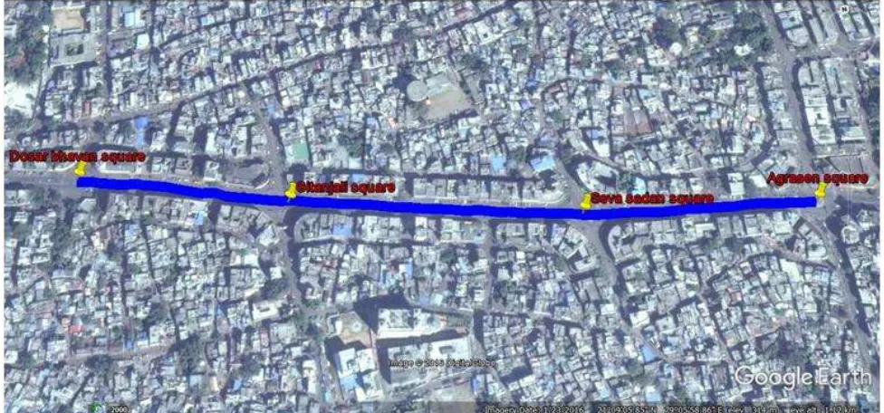
Nagpur located at precisely center of the India which is 3rd largest city in Maharashtra after Mumbai and Pune, known as Orange city. It is the winter capital of Maharashtra and 2nd greenest city in India. For signal optimization and coordination purpose the study route is selected which is situated in center of the nagpur city, The route is located on centeral avenue road nagpur which is consider as one of the busy route of the city as the population near the area is large and market areas are also situated around this region hence traffic congestion on this route is a problem.The selected corridor has four signal control intersections which are close to each other but due high traffic volume and non cordination of signals, the signals usually runs beyond their saturation capacity and queue formation is a common problem on intersections hence this route is selected as a study corridor for green splitting and signal cordination purpose.
The name of intersections are Dosar bhavan square, Gitanajali square, Seva sadan square and agrasen square. The spacing between Dosar bhavan square to Gitanajali square is 250m, Gitanjali square to seva sadan square is 350m and seva sadan square to Agrasen square is 260m.The total length of study corridor is 850m.
Geographical location
Fig. 1: Study corridor from Dosar Bhavan square to Agrasen square
Data Collection
In this study the volume count is done by videography technique in which data during morning peak hour is collected. Volume count is carried out is collected at all four intersection the data is extracted by tally sheet method. Geometric data of road network is measured manually from field. Spot speed data is collected by using manually by using stop watch method in which 50m road section is selected and from time and distance formula speed is evaluated.
Signal design
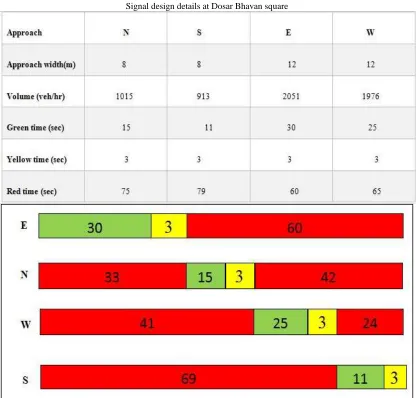
All the four signals are designed by using Webster method of signal designed. Following are the design details of signal at Dosar Bhavan square.
Fig. 2: Image of Dosar Bhavan square
Fig. 3 Phase diagram at Dosar Bhavan square
Signal coordination
Signal coordination is one the important techniques in traffic management system in which signals which are closely spaced to each other are coordinated so that the maximum number of vehicle over a coordinated stretch will get continuous green light while travelling over coordinated corridor. In this study the corridor which is selected has four intersections which are very close to each other hence such road network required to be coordinated to decrease queue length, delay and travel time. In this study one way signal progression is done from Dosar Bhavan square to Agrasen square. Signal coordination is done by theoretical method by considering time required to reach each intersection, pre apportioned average speed of vehicle, offset and green phases of each intersections.
Development of simulation model in VISSIM
VISSIM is microscopic multimodal traffic flow simulation software which is used to make simulation model of real condition by considering various factors such as driver’s behavior, lane changing operations and traffic characteristics. In this study simulation model of road network is prepared on PTV VISSIM. Parameters as model input is properly assigned while preparing simulation model this parameters are driver’s behavior, lane changing operation, composition and characteristics of vehicle, desired speed and acceleration of vehicles.
Fig. 4: Network model in PTV VISSIM
III. RESULT AND DISCUSSION
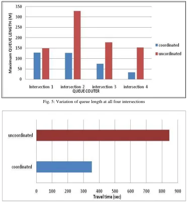
Signal coordination mainly use to demote travel time ,queue length and travel time on a busiest routes hence the results evaluated from simulation model is compared before and after coordination on the basis of queue length ,travel time and delays the results are presented as follows.
[5] Mohammed javad shervani et, al.(2015)”Maximum Green Time Settings for Traffic Actuated Signal Control at Isolated Intersections Using Fuzzy Logic” (2015 4th Iranian Joint Congress on Fuzzy and Intelligent Systems (CFIS).