MObIle techNOlOgy uSed IN aN
adVeNturOuS OutdOOr learNINg
actIVIty: a caSe Study
Viera Palmárová, Gabriela Lovászová
constantine the Philosopher university in Nitra, Slovakia e-mail: [email protected], [email protected]
Abstract
Digital devices like smart phones, tablets, PDAs and GPS navigators provide teachers in primary and secondary schools with new and attractive chances to teach in a constructivist/constructionist way. The research was aimed at designing an engaging outdoor learning activity based on collaboration and active using of mobile technology. The suggested learning activity was inspired by a real-world treasure hunting game called Geocaching and was realized with 2 groups of pupils aged 10-14. Children used a GPS-enabled PDA to navigate from their current location to another. They encountered various types of problems while collecting hints needed to calculate the final location of a hidden container. Even collaboration between competing teams was necessary in order to succeed. The case study gives an example of a well-designed constructivist/constructionist learning activity with special focus on informatics education but can be easily adapted for using in any other school subject or some after-school context as well. The adventurous and competitive nature of the learning activity resulted in high intrinsic motivation to learn, so the educational objectives could be reached effectively. Reported findings are grounded in observations made during the learning activity as well as the interviews with participants.
Key words: constructivism, Geocaching, informatics education, mobile technology.
Introduction
mobile technology known as Global positioning system (Gps) has become popular especially because of the intelligent navigation in cars. but Gps receivers are used for many other reasons: by rescuers, policemen, sportsmen, carriers, geodesists, map makers, natural scientists, even by researchers in humanities or artists. nowadays, mobile devices capable of receiving the Gps signal (e. g. tourist navigators, pdas, smart phones) are widely accessible also to public, so there is a new chance to use satellite navigation as a learning tool as well as for entertainment.
school activities can draw on existing Gps games. the most popular Gps games include Geocaching, Gps drawing and Wherigo. next subsection provides basic information about these games as they inspired the investigated learning activity. then, some other concrete examples of successful application of mobile technology in education are described. the second chapter introduces an original Gps-enabled learning activity with an educational goal concerned with informatics education.
Geocaching, GPS Drawing, Wherigo
of education in the 21st century Volume 44, 2012 65
for a real treasure. Geographical coordinates of caches are published online (www. geocaching. com). caches are founded by volunteers, usually in places that are interesting to visit (cultural sights, historical monuments, beauties of nature etc.). the container usually contains a logbook, a pencil and some souvenirs. after discovering the cache, players (geocachers) are obliged to sign the logbook and after returning home, they log their experience online to share their success or failure with a geocaching community. there are more variants of the game (e. g. traditional caches, mystery caches, multicaches, event caches, caches with travel bugs etc.). caches are of various sizes, designs and difficulty (Groundspeak, inc., 2012a).
GPS Drawing combines art, walking (running, cycling, driving, flying etc.) and Gps technology. players record their tracks with the help of a Gps unit. later, they visualize collected data and make a digital picture. the movement of a player should be planned carefully in advance to get the anticipated result. nice drawings over land, on water, and in the air are made e. g. by Jeremy Wood (Wood, 2012).
Wherigo is a platform that allows anybody to build location-based Gps experiences on a computer and play them in the real world. typical Wherigo offers a sightseeing tour or a fictional adventure game (inspired by a fairy tale, some sport activity, a board game, a true story etc.). players have to visit specific places (called zones) during the game, they fulfil tasks, find, collect and use virtual or even real objects. to play a Wherigo game, a Wherigo cartridge has to be downloaded and the Wherigo Player application must be installed into some Gps-enabled device. Wherigo cartridges are created (programmed) by volunteers from the geocaching community and published on the dedicated portal (Groundspeak, inc., 2012b).
Mobile Technology in Education
the learning activities powered with mobile technology may differ as for their goal
(e. g. recreational, educational, combined), organizational form (a simple task during one lesson, a long-term project, a competition during a school trip), difficulty (passive recording of geo-data while walking in park, active navigating to localize a cache, a real-time strategic action game), length and collaboration level of participants. in (spikol & milrad, 2008), a Wherigo-like adventurous game based on local historical facts and ghost legends is described. the authors of (sugimoto, ravasio & enjoji, 2006) used tablets in an outdoor project. pupils were divided into more teams and asked to explore the area around their school to document interesting objects, plants and animals in a multimedia way. all digital data were joined in the end to create a common interactive map. the paper (Wijers, Jonker & drijvers, 2010) shows how to use Gps technology in teaching mathematics. two-member teams were tasked to construct as many virtual parallelograms by moving in a terrain as possible (there was a time limit). When visiting the right points, they could even destroy parallelograms of their opponents to get some bonus points.
GPS-enabled Learning Activity: a Case Study
Objectives
the main purpose of this research study was to develop (design and examine) an outdoor learning activity that would be:
• mediated by mobile technology (e. g. pda equipped with a Gps unit),
• focused on fundamental concepts behind the satellite navigation,
• suitable for using in lower secondary education,
• game-based,
• and collaborative.
pupils should learn about the popular Gps technology by using it in action. it can be assumed that problem solving learning activities are engaging for pupils when being presented within the context of an adventurous game. to encourage other social constructivist attributes of the learning process, a decision to involve pupils in some kind of meaningful collaboration was made.
General Scenario of the Learning Activity
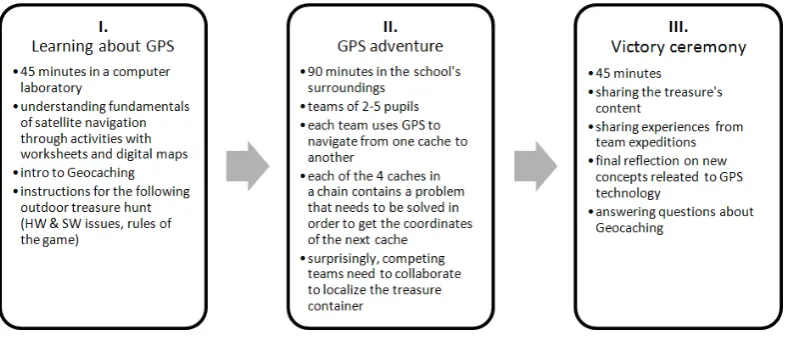
figure 1 presents 3 phases of the suggested learning activity. the first phase takes place indoors, in a computer laboratory. during this preparation phase, pupils get familiar with Gps technology. they are reminded of geographical coordinates and discover the procedure of determining a specific location with help of satellites that orbit the earth and a Gps receiver.
Figure 1: Phases of the suggested learning activity.
of education in the 21st century Volume 44, 2012 67
game may be a bit surprising but socially beneficial. the victory ceremony can be considered also as the opportunity to reflect on the preceding adventurous and technology experience as well as to enhance pupils’ interest in popular Gps games, especially Geocaching.
Methodology of Research
the proposed scenario was implemented in autumn 2011 with 10 pupils aged 10-14 attending the elementary school at benkova street in nitra (the group was quite heterogeneous, there were 6 boys and 4 girls from 5th to 9th grade, pupils had not learned about Gps technology
before). the 2 competing teams were created spontaneously by children (5 members per team). the younger pupils formed the a team, the older pupils formed the b team. each team was given the same navigation device (pda mio p650 with Windows mobile) with preinstalled
BasicGPS. this software is a free navigation tool for geocachers with intuitive Gui suitable for beginners.
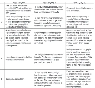
table 1 provides an overview of the indoor activities. it explains what pupils actually did and why they did it. the last column of the table 1 provides some additional remarks concerned with the scenario’s implementation.
Table 1. Overview of the indoor activities realized during the preparation phase.
What to do? Why to do it? hoW to do it?
1
Free talk about devices with embedded GPS unit and their us-ing in our everyday life (includus-ing GPS games)
To find out what pupils already know about the topic and motivate them to
learn something new and useful
Every pupil shared his/her experi
-ence with others.
2
Active using of Google maps to localize several places defined by their geographical coordinates or to determine geographical coordinates of specific places
To train the terminology of geographi
-cal coordinates as well as get used
to decimal format of geographical coordinates typical for Geocaching
Pupils explored digital map of their city/village and localized some of their favourite places (school, playground, place of
residence etc.).
3
A role playing game about rescu
-ers who are looking for a tourist lost somewhere in the wild. the
lost person reports distances from significant objects in the area, rescuers use map to guess his/her position.
When trying to identify the position of a lost person on the map, pupils
can discover the idea of triangulation
themselves, applying the trial-and-er
-ror method.
As a rescuer, each pupil worked
with his/her map and tried to con
-struct the intersection of 3 circles
using a pencil and a drawing-compass. First, a teacher played the lost person. Then, a pupil
took turn.
4 instructions necessary to start the treasure hunt adventure
the navigation software is introduced
to pupils. Pupils need to understand
the visual representation of geo
-graphical data correctly.
During the treasure hunt, pupils need to input new coordinates
into their mobile devices more than once. demonstration of this
procedure was postponed to the moment just before sending
teams to their individual expedi
-tions.
5 Starting the competition
to start the GPS adventure right
from the computer laboratory, pupils can localize the first common cache on the map. The coordinates are unknown; the first problem needs to
be solved to get them.
Pupils were asked to construct an origami model (to execute an algorithm). The sheet of paper
used for folding contained many numbers. the right coordinates
presenting the real Geocaching game to beginners (pupils). the assignments that were put inside these containers differed as for their type and difficulty. pupils had to
• search for information inside the university building (pupils were visiting constantine the philosopher university that day, so it was interesting for them to learn something about the academic life),
• solve logical puzzles (e. g. simpler version of the famous einstein’s riddle),
• search for information on panels situated in the terrain (e. g. on a bridge, near a petanque playground),
• calculate new coordinates after getting values for substitution,
• collect small artefacts discovered in caches (e.g. colourful links of a potential chain),
after reading the instructions found in last caches, both teams got back to the university building. then all the participants were forced to collaborate while trying to answer the final question. after noticing the relation between a strange verse about a snake with national consciousness (�also a snake loves slovakia�) and the chain of white, blue and red links�also a snake loves slovakia�) and the chain of white, blue and red linksalso a snake loves slovakia�) and the chain of white, blue and red links (national colours of slovakia), pupils were able to calculate the result and the competition was accelerated immediately again. the team b found the final cache first and so won the competition. the treasure contained several dozens of chocolate ducats.
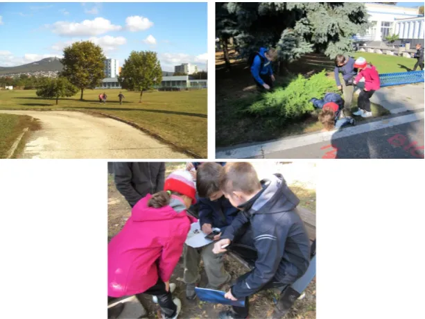
to examine the realized learning activity in depth, the qualitative approach was applied. during the Gps adventure, each team was guided by two adults (a researcher and a teacher from the elementary school). the two helping teachers were not participating actively. they were just observing the situation. they were asked to make notes about pupils’ actions and statements and were taking photos to document the treasure hunt’s course (figure 2).
Figure 2: Team A during their expedition (navigating, looking for a cache, up-dating GPS coordinates).
of education in the 21st century Volume 44, 2012 69
of view and a pupil’s point of view). both teachers as well as all children were interviewed after finishing the learning activity. the conducted interviews were semi-structured. there were more research questions to answer:
1. did pupils enjoy the learning activity? 2. did pupils learn something new?
3. Was the learning activity beneficial from the social-constructivist point of view? 4. Were there any significant differences between the older and the younger pupils (as for
their behaviour or level of interest)?
Results of Research
results of the data analysis are presented in relation to the stated questions:
Engagement of the Learning Activity
all participants enjoyed the learning activity very much. both teams were ambitious from the very beginning to the end, they approached every challenge seriously. even while walking from one checkpoint to another, they were wondering about the treasure and thinking of the final riddle. the Gps adventure was successful, the weather was nice, and Gps signal was reliable throughout the whole game. pupils did not refer any technical problems with their mobile devices. both, the indoor as well as the outdoor assignments were accepted positively and so found appropriate. both teams walked approximately same distance and got back to the starting place almost at the same time. the competing teams did not meet nor see each other while exploring the terrain. as pupils were not sure what was going on in the other team, they were extremely motivated to progress quickly. during the �victory ceremony�� phase, children�victory ceremony�� phase, childrenvictory ceremony�� phase, children were asking about details of the Geocaching game. they seemed to be motivated to become geocachers, willing to try Geocaching also at home, with their parents or friends.
Learning Outcomes
all pupils were able to explain the fundamental idea behind the Gps technology. during the outdoor part of the activity, they worked with pdas and its navigation software naturally. short initial �how to do it�� demonstration was sufficient�� there were no additional questions�how to do it�� demonstration was sufficient�� there were no additional questionshow to do it�� demonstration was sufficient�� there were no additional questions during the game. pupils were moving rather randomly while trying to localize the first cache. it took them approximately 15 minutes until they understand the meaning of a navigation arrow properly as well as to accept that Gps signal is not always accurate and updates are often not immediate. pupils got information about the Geocaching game as a useful bonus.
Collaboration
for all younger children, it was very attractive to hold pda in hand. the older pupils delegated this responsibility to their captain. younger pupils were very excited during the whole Gps adventure (they were running to the target location). the older pupils took it a bit easier (they were walking). one of the younger children was tired and lost interest in discussion during the last phase.
Discussion
the learning activities should not be too difficult or too trivial for pupils. pupils always need some intellectual challenge that would shift their knowledge a step further. in this case, pupils used mobile technology in a way that was new and very attractive for them. they worked with software application for processing geographical data. as the learning activity took 3 hours, there was plenty of time for performing experiments, considering various solutions and learning from errors. the learning activity was aimed at fostering the ability to interpret collected data properly and using mobile technology to solve a real-world problem. tasks-world problem. tasksworld problem. tasks inserted into the game through containers in caches were meant to support the social aspects of learning. children had no previous experience with Geocaching, so the focus was on the act of navigation using Gps technology. the requirement of solving some highly specific or complex problems would be counter-productive.
during collaborative learning activities, partners may divide the labour vertically into independent subtasks and then assemble the partial results into the final result. this approach is known as �divide and conquer��. another way of collaboration is �joint effort�to complete some�divide and conquer��. another way of collaboration is �joint effort�to complete somedivide and conquer��. another way of collaboration is �joint effort�to complete some�joint effort�to complete somejoint effort�to complete some�to complete some complete some task when partners actually do the work together. in this case, pupils applied the second strategy�� each of them took part in solving every partial problem and tried to contribute constructively. the collaboration sped up the process of competition.
When planning the Gps-enabled learning activities, teachers had to take the weather and the hardware issues into account. besides lowering the comfort of participants, the rainy weather can influence the quality of the Gps signal negatively. the loss of Gps signal or some other technical problems with Gps receivers could totally ruin the potentially joyful experience. every Gps game should be pre-tested by teachers first to avoid risks related to the movement in a real terrain. teachers must be careful when deciding locations of the caches. the caches should be founded on interesting and safe places, length and difficulty level of tracks planned for the competing teams should respect the age of participants.
after finishing a Geocaching-like adventure, it is possible to continue the learning activity during the following lesson at school. for teachers, it could be another good chance to make pupils reflect on new concepts, to summarize and verbalize them. pupils can log their success on a Geocaching portal or a personal blog, they can process Gps data collected in the terrain or even develop new Gps adventures inspired by their previous experiences.
Conclusions
the presented case study gives an example of a well-designed constructivist/ constructionist learning activity with special focus on informatics education but can be easily adapted for using in any other school subject or some after-school context as well (e. g. during a school trip or a sport day). the adventurous and competitive nature of the learning activity resulted in high intrinsic motivation to learn, so the educational objectives (understanding the fundamentals of Gps technology) could be reached effectively.
of education in the 21st century Volume 44, 2012 71
teachers assisted pupils when needed. but pupils were the active subjects of the learning process. experiencing productive collaboration while coping with problems during the game strengthens the feel of being a friendly community member and influences the communication and social competences of pupils positively.
constructivism and constructionism are learning theories that also point out meaningfulness of the learning activities. searching for a hidden container, drawing a virtual geoglyph or playing an adventure game in the real world – all these activities possess a huge motivating potential.
it is a typical attribute of all Gps activities that they are realized outdoors (at least partially), so children are involved in a physical activity. in this way, Gps activities contribute also to a healthy lifestyle.
References
ackermann, e. K. (2010). constructivism (s): shared roots, crossed paths, multiple legacies. in clayson, J., Kalaš, i. (eds.) constructionism 2010, proceedings of the 12th euro logo conference, paris, 16-20 august 2010.
dillenbourg, p. (1999). What do you mean by collaborative learning? in p. dillenbourg (ed.) Collaborative-learning: Cognitive and Computational Approaches. oxford, elsevier. pp. 1-9.
Groundspeak, inc. (2012a). Geocaching. retrieved 02/10/2012 from http://www.geocaching.com/ Groundspeak, inc. (2012b). Wherigo. retrieved 02/10/2012 from http://www.wherigo.com/
spikol, d., milrad, m. (2008). physical activities and playful learning using mobile Games. Research and Practice in Technology Enhanced Learning, 3 (3), 275-295.
sugimoto, m., ravasio, p., enjoji, h. (2006). sketchmap: a system for supporting outdoor collaborative learning by enhancing and sharing learners’ experiences. in Proc. of ICCE Workshop on Design and Experiments of Mobile and Ubiquitous Learning Environments, beijing, china, pp.1-8. Wijers, m., Jonker, V., drijvers, p. (2010). mobilemath: exploring mathematics outside the classroom.
ZDM: The International Journal on Mathematics Education, 42 (7), 789-799. Wood, J. (2012). GPS Drawing. retrieved 02/10/2012 from http://www.gpsdrawing.com/
Advised by Milan Turčáni, Constantine the Philosopher University in Nitra, Slovakia
received: May 06, 2012 accepted: June 11, 2012
Viera Palmárová PaedDr., PhD., Assistant Professor, Department of Informatics, Faculty of Natural Sciences, Constantine The Philosopher University in Nitra, Tr. Andreja Hlinku 1, 949 74 Nitra, Slovakia.
E-mail: [email protected] Website: http://www.ki.fpv.ukf.sk/
Gabriela Lovászová RNDr., PhD., Assistant Professor, Department of Informatics, Faculty of Natural Sciences, Constantine The Philosopher University in Nitra, Tr. Andreja Hlinku 1, 949 74 Nitra, Slovakia.