Problems of GIS-Aided Wildfire Decision Support
System Development
Vitold Komorovski
1,*, George Dorrer
2, Peter Osaveluk
11Siberian fire rescue academy of Russia EMERCOM, Academgorodok 50a-2 660036 Krasnoyarsk, Russia 2Siberian state technological University, Mira 80 660049 Krasnoyarsk, Russia
*Corresponding Author: [email protected]
Copyright © 2014 Horizon Research Publishing. All rights reserved.
Abstract
In the paper some problems of specialGIS-based software tools development are considered. The main purpose of our work is to develop the decision support system for specialists extinguishing wildfires near settlements and other economical objects. System architecture is presented and most complex points discussed. The base of this system is a geoinformational module. Accounting some local conditions is considered and some algorithmic decisions are offered. Wildfire spreading rate is calculated, using indicatrices.Decision making algorithm is considered in detail.Presented system is intended for the fire service specialists mostly in Russia, but we believe it might be easily extended to resolve the general fire management tasks in different countries.
Keywords
Geoinformational Systems, Wildfire,Indicatrices, Decision Making, Decision Support System
1. Introduction
Nowadays such terms as “sustainable forestry” and “fire management” are broadly used. Information systems have to be used to realize these conceptions. There is a lot of information systems used in wildfire management area. In some cases, such systems don’t use geoinformation functionality, but usually they do. For example, system “BehavePlus” (P. Andrews, 2007) does not use GIS itself. But FARSITE (M. Finney, 1998), FlamMap (M. Finney, 2006), IDSM-Rosleskhoz (Ershov et. al. 2004) and many other systems have broadly been using GIS. In different classes of information systems the decision support systems are little represented. In case of wildfires extinguishing, it is reasonable to list the following tasks of the decision support system to solve:
1. Estimation of regional fire conditions 2. Estimation of threat for protected objects 3. Wildfire behavior forecast
4. Wildfire rate forecast
5. Calculation of fire extinguishing forces
6. Calculation of damage
Our purpose is to develop the software providing support to make decision in cases of wildfires extinguishing near settlements and other economical objects. To make a correct decision a specialist has to take into account a lot of different factors. Firstly, it is a spatial position of fires and protected objects. Secondly, it is a position of firefighters. Thirdly, it is a different landscape features. Thus, we should use GIS as a basis of our system both to taken into account all factors and conveniently to present the computation results.
Developing system has to correspond to the following requirements:
1. Orientation to using remote sensing data. 2. Simple interface with a minimum of additional
functions.
3. Opportunity of different vector layers containing required information to be loaded.
We faced some difficulties during development both in algorithmic and interfacing points. To overcome these difficulties, we developed some original decisions.
2. Materials and Methods
2.1. Mathematical Statement
Let us consider target objects characteristics. Let
P(t)={p1(t), p2(t), …, pm(t)} be a set of wildfire spreading processes. Let B={b1, b2, …, bn}be a set of protected objects. Protected object is characterized by coordinates: bi→ {xi, yi},
i=1…n. Wildfire spreading processes are characterized by array of points forming fire outline or an approximating set:
P(t)→{Xj(t), Yj(t)}, j=1…m; (1) or
S(t)={s1(t), s2(t), …,sm(t)} (2) where S(t) – dynamic wildfire area set, t - time.
Interaction between wildfires and protected objects is characterized by matrix L(t)=||lij(t)||, i.e. matrix of minimal distances from bi to pj(Fig. 1).
(3) Then, elements of set M(t) are fires causing damage to protected objects and are defined as follows:
(4) To rank elements of set M(t) let us confront:
(5)
whereQ is a set of parameters affecting the appearance of set
M(t)element. Thus, we should define the following points:
1. Elements of set Q; 2. Function f(Q, t);
3. To calculate t*for certain element of S(t) 4. To calculate all M(t)at certain t≥ t*.
[image:2.595.320.548.120.340.2]Our problem solution will be considered below.
Figure 1. Wildfires and protected objects interaction scheme
2.2. General Functionality of GIS Module
Main operations should be available are loading and unloading vector and raster layers. Then, it is needed to have opportunity to change the scale, move the layer, and select the layer objects. As for the vector layers we should additionally have a possibility to work with attribute table. To provide GIS functionality in software we can develop a plugin to GIS platforms such as ArcGIS or Quantum GIS. Another way is to develop our own application using special GIS components. We chose MapWinGIS ActiveX control component (MapWinGIS project, 2013) as a platform providing some necessary functions. There are some good reasons for this control component to be chosen, as we developed our application for Microsoft Windows platform and used a Delphi as a programming language. On the other hand,MapWinGIS is free and open source project. Project has a good API documentation and examples, as well. Using MapWinGIS is very simple for a developer. It is only needed to add a special component called “map” to an application
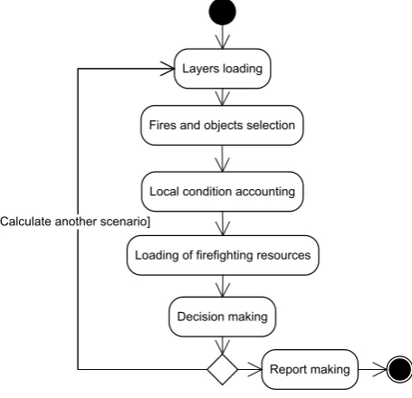
form. All general GIS functionality is available by this component. Principal scheme of our program working is presented as a UML state diagram in fig. 2.
Figure 2. UML state diagram of decision making software
According toour application purposes we should have an opportunity to load wildfire remote monitoring data. There are two ways to carry out. Some data is presented as a shape file (*.shp). This simple case and necessary data to our application are directly loaded. The second way is more complex. In this case, monitoring data are saved in PostgreSQL database. To load it, remote connection to database and SQL queries are used.
There is a very important point to be taken into account: all loaded data must have the same projection. Because the data used can be obtained from different sources, projection can also be different. So we foresee the function to reproject input data, but it does not automatically work and user has to use it himself.
The last point to be mentioned in this section is choosing the layer type. It is necessary for user to note what information this layer represents. Generally, there are three types of layers: fire’s layer, protected object’s layer and other additional layer.
2.3. Accounting Local Conditions
There are a lot of factors affecting wildfire behavior. For example, wind direction and speed, slope direction and gradient, humidity of fuel material, even time of day. It cannot be taken into account all conditions. To begin with, let us define the main conditions affecting wildfire or elements of set Q described above. We took into account the following factors:
1. Windspeedanddirection
2. Humidity of natural fuel material 3. Type of forest, i.e. main species of plants
4. Type of fire, for example, crown fire, ground fire,etc.
∅
≠
∩
=
t
S
t
B
t
* min:
(
)
B
t
S
t
M
(
)
=
(
)
∩
)
,
(
)
(
t
Q
f
U
U
t
M
i
i i
=
→
b
1b
2b
3l
11l
12l
13l
21l
22l
23p
1p
2w
X
Y
Layers loading
Fires and objects selection
Decision making Local condition accounting
Loading of firefighting resources [Calculate another scenario]
[image:2.595.64.296.300.484.2]5. Types and quantity of fire extinguishing resources 6. Presence or absence of barriers for fire spreading
The main factor influencing on the decision making is a wildfire rate. To calculate its value, we use simple approach described below as an algorithm. Firstly, the wildfire rate might be known. It means that decision making person, by some reasons, directly put rate value into the program. More frequently, user doesn’t know the exact value of wildfire rate, but one can obtain values of local conditions. In Russian forestry practice, all parts of forests are virtually characterized by values of so-called natural fire danger class. Humidity of natural fuel material is characterized by fire dangerous class according to weather conditions. This parameter is daily calculated based on meteorological data. In North America each forests parts might be characterized by the number of fuel models. As our program is mostly uses under Russian conditions, we will rely on Russian practice below. Generally, main approaches and algorithms could easily be adjusted to other conditions. There are some approaches to calculate wildfire spreading rate. Empirical data are used (Andreev Y., Brukhanov A., 2011). The base value of rate v0 is a tabular value of function depending on conditions listed above. There are two function values for each condition: minimum possible rate and maximum one. We can use the base value of rate assuming isotropic spatial conditions. Conditions are anisotropic indeed. The main factor affecting the rate irregularity is a wind speed. So we used the following conditions:
𝑣𝑣0= �
min(𝑣𝑣0) , 𝑤𝑤 ≤ 1 𝑚𝑚/𝑠𝑠 ∆𝑣𝑣0
5 ∙ 𝑤𝑤 + min(𝑣𝑣0) − ∆𝑣𝑣0
5
max(𝑣𝑣0) , 𝑤𝑤 ≥ 6 𝑚𝑚/𝑠𝑠
, 1 < 𝑤𝑤 < 6 𝑚𝑚/𝑠𝑠(6)
where v - fire spreading rate, w - wind speed,
v0=max(v0)-min(v0).
The next important task is to calculate fire spreading rate depending on azimuth i.e. angle between wind direction and direction to the protected object. Elements of wildfire spreads with different rate, therefore we should take into account the azimuth. We suppose that shape of wildfire is symmetrical related to direction of the fastest spreading. So we calculate the azimuth as follows:
𝑐𝑐 = 𝑠𝑠𝑠𝑠𝑠𝑠(𝜔𝜔); 𝑑𝑑 = 𝑐𝑐𝑐𝑐𝑠𝑠(𝜔𝜔);
Here c and d are elements of unit vector, 𝜔𝜔 − angle of wind direction. Then we move a coordinate system origin to center of fire as follows:
𝑥𝑥0= 𝑥𝑥2− 𝑥𝑥1
𝑦𝑦0 = 𝑦𝑦2− 𝑦𝑦1
where (𝑥𝑥0, 𝑦𝑦0) – new coordinate system origin, (x1, y1) –
center of wildfire, (𝑥𝑥2, 𝑦𝑦2) – center of protected object. So
azimuth we found as follows:
𝜑𝜑 = arccos �𝑥𝑥0∙𝑐𝑐+𝑦𝑦0∙𝑑𝑑
�(𝑥𝑥02+𝑦𝑦02)
� (7)
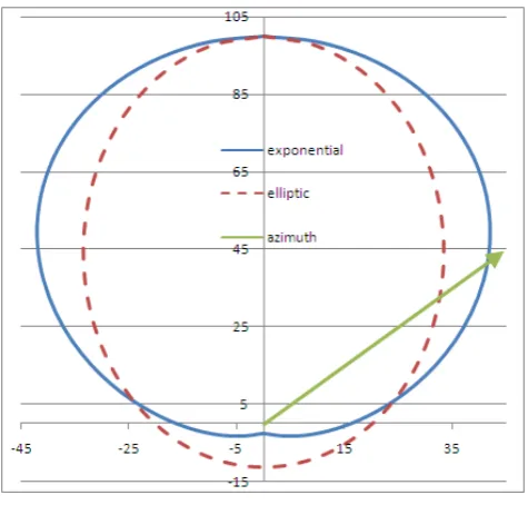
After azimuth calculation we should to recalculate wildfire rate in given direction. To perform this computation we used special functions called indicatrices. Choice of indicatix depends on wind speed as follows:
�𝜉𝜉(𝜙𝜙) = 𝑒𝑒
𝛼𝛼(𝑤𝑤)∙(cos (𝜙𝜙)−1), 𝑤𝑤 ≤ 3𝑚𝑚/𝑠𝑠,
𝜉𝜉(𝜙𝜙) =1−𝜀𝜀(𝑤𝑤)∙cos (𝜙𝜙)1−𝜀𝜀(𝑤𝑤) , 𝑤𝑤 > 3𝑚𝑚/𝑠𝑠 (8) where α(w) and ε(w) special coefficients calculated as follows:
𝑎𝑎(𝑤𝑤) = 0.785 ∙ 𝑤𝑤 − 0.06 ∙ 𝑤𝑤2
𝜀𝜀(𝑤𝑤) = 1 − 𝑒𝑒−0.4∙𝑤𝑤
[image:3.595.314.552.248.475.2]To illustrate how indicatrices approximate wildfire rate we represent fig. 3.
Figure 3. Exponential and elliptic indicatrices
Then, to calculate wildfire rate in certain direction v, we should follow:
𝑣𝑣 = 𝑣𝑣0∙ 𝜉𝜉(𝜙𝜙) (9)
Let v0 be 100 m/hour, wind direction 0 radian and ϕ=π/4 radian. Then, in case if wind speed is 3 m/s, we used the exponential indikatrix and v=58.8 m/hour. In case when wind speed is 4 m/s we use the elliptic indicatrix and v=46.3 m/hour. It should be noted that meters per hour and hours are very convenient units of measurement in this case.
When we know a wildfire spreading rate we should calculate minimal distances between fire outlines and protected object boundaries. It is not difficult task. Because of we represent both wildfires and protected objects as polygons, the simplest way is to calculate distances between polygon nodes and to find minimal ones. To obtain distances we used embedded MapWinGIS’s function. After that, we have rate, distance and a possibility for reach ability time computation as follows:
𝑡𝑡∗=𝐷𝐷
Obviously, we should calculate t* for each element of S(t) set. So we are close to solve main problem stated above: to rank wildfires by its danger level. But short reach ability time is not obligatory characteristic of fire danger. Additionally, we use an estimation of the fire extinguishing time. Every fire-fighting vehicle, other fire-fighting tool or even fireman have a standard characteristics of fire-fighting efficiency. Using this standard valuesallow oneto calculate fire extinguishing time T, hours, as follows:
2 2
( 1)
L L n
T
n V
n W v
⋅ −
= +
⋅
⋅ − (11)
where L- outline length, m, W – fire-fighting tool speed during extinguishing, m/h, n – number of tools, V –fire-fighting tool speed under forest conditions, m/h.When considered ground fire with low or middle intensity it is not necessary to take into account extinguishing or localization of all fire outline length. It can be constrained by a half of length, i.e. L/2 in (11).
There are three main cases to be considered: 1. t*>>T, extinguishing isn’t urgent; 2. t*≈T, extinguishing is urgent;
3. t*<T, extinguishing is urgent, additional forces are necessary.
It is necessary to consider the cases listed above for each pair wildfire-protected object. So, it can be added an additional value U, urgency of decision making:
U=t*-T (12) Here we define the ranking rule from formula (5). Ranking of S(t), B elements is performed according to U value. Decision making process is based on ranked lists of elements
S(t), B. Generally, all components of formula (12) are dynamic, i.e. U(t), t*(t), T(t). In such statement some interesting tasks arises. For example, urgency isochrones can be drawn on a map. We won’t consider this kind of tasks here, because it’s beyond the scope of the paper.
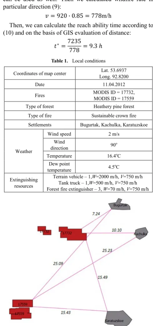
3. Results and Discussion
Let’s consider simple example of calculations described above. Conditions are listed in table 1 and scheme of vector layers is presented in fig. 4. Connection lines in fig. 4 have distance labels. Distances are presented in kilometers. One case will be considered in detail.
3.1. Calculation Example
Coordinates of wildfire 17732 are (53.756; 92.772), coordinates of Bugurtak settlement are (53.813; 92.875). According to the formula (7) and table 1 data we can obtain following azimuth:
𝑐𝑐 = 𝑠𝑠𝑠𝑠𝑠𝑠(900) = 1;
𝑑𝑑 = 𝑐𝑐𝑐𝑐𝑠𝑠(900) = 0;
𝑥𝑥0= 53.813 − 53.756=0.057;
𝑦𝑦0= 92.875 − 92.772=0.103;
𝜑𝜑 = arccos �𝑥𝑥0∙ 𝑐𝑐 + 𝑦𝑦0∙ 𝑑𝑑 �(𝑥𝑥02+ 𝑦𝑦02)
� = 28.960
The next step is to calculate fire spreading rate in azimuth direction. According to (8):
𝑎𝑎(𝑤𝑤) = 0.785 ∙ 2 − 0.06 ∙ 22= 1.33
𝜉𝜉(𝜙𝜙) = 𝑒𝑒1,33∙(cos (28.96)−1)= 0.85
We choose wildfire rate v0 = 920 m/h according local natural conditions and weather data. Wildfire rate forecast can be used as well. Then we calculated wildfire rate in particular direction (9):
𝑣𝑣 = 920 ∙ 0.85 = 778m/h
Then, we can calculate thereachability time according to (10) and on the basis of GIS evaluation of distance:
𝑡𝑡∗=7235
[image:4.595.306.552.212.734.2]778 = 9.3 ℎ Table 1. Local conditions
Coordinates of map center Long. 92.8200 Lat. 53.6937
Date 11.04.2012
Fires MODIS ID = 17732, MODIS ID = 17559 Type of forest Heathery pine forest Type of fire Sustainable crown fire Settlements Bugurtak, Kachulka, Karatuzskoe
Weather
Wind speed 2 m/s Wind
direction 90o Temperature 16.4oC
Dew point
temperature 4.5oC Extinguishing
resources
[image:4.595.318.546.512.738.2]Terrain vehicle – 1,W=2000 m/h, V=750 m/h Tank truck – 1,W=500 m/h, V=750 m/h Forest fire extinguisher – 3, W=70 m/h, V=750 m/h
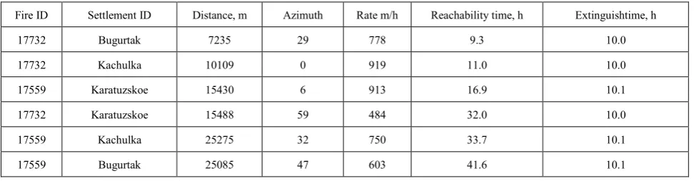
Table 2. Calculation results
Fire ID Settlement ID Distance, m Azimuth Rate m/h Reachability time, h Extinguishtime, h
17732 Bugurtak 7235 29 778 9.3 10.0
17732 Kachulka 10109 0 919 11.0 10.0
17559 Karatuzskoe 15430 6 913 16.9 10.1
17732 Karatuzskoe 15488 59 484 32.0 10.0
17559 Kachulka 25275 32 750 33.7 10.1
17559 Bugurtak 25085 47 603 41.6 10.1
General characteristics of extinguishing resources (according toAndreev Y., Brukhanov A., 2011) are listed in table 1. According to GIS measurement, outline length of fire 17732 is 19546 m. Using formula (11) and table 1 data, we can obtain:
2 2
19546 19546 (4 1) 10.0
4 1620 4 5200 778
T= + ⋅ − = h
⋅
⋅ −
3.2. Processing Results by Developed Software
For more convenient data processing we developed the special software. Using this tool, we have obtained results shown in table 2.
According to this scenario, we have to engage additional forces and to block directions Bugurtak and Kachulka at first. We made calculation assuming wind speed about 2 m/s. Fortunately, there was calm indeed. Tests of decision support system have been performed on remote sensing data. Testing data have described fires in Siberian region since 1996 – 2012.
4. Conclusions
There are great difficulties in decision making for numerous of wildfires to be extinguished. Decision support systems are able to significantly assist in wildfire extinguishing. The reason why we use GIS-aided decision support system is spatial wildfire distribution. One of the most complicated problems is local conditions accounting. Approaches we use allow take into account the spatial and dynamic characteristics of wildfires. To calculate wildfire rate we have used indicatrices. Wildfire ranking have been performed by wildfire reach ability time and fire extinguishing time comparison. Original decision is to combine different approaches: tabular value of fire rate function and indicatices as a consequence of wave fire representation. The main customer of presented system is Siberian regional center of Russian emergency ministry, but
algorithmic bases of system have not strictconstraines. Such system is believed to be easily adapted to other conditions.
REFERENCES
[1] Andrews, Patricia L. BehavePlus fire modeling system: past, present, and future. In ‘Proceedings of 7th Symposium on Fire and Forest Meteorology.’American Meteorological Society, 23-25 October 2007, Bar Harbor, Maine,http://ams.confex.com/ams/pdfpapers/126669.pdf13 p.
[2] Finney,Mark A.. FARSITE: Fire area simulator-model development and evaluation. // Res. Pap. RMRS-RP-4, Ogden, UT: U.S. Department of Agriculture, Forest Service, Rocky Mountain Research Station.,http://www.farsite.org, 1998, 47 p.
[3] Finney, Mark A. 2006. An overview of FlamMap modeling capabilities. In: P.L. Andrews, B.W. Butler (comps.). Fuels Management – How to measure success: Conference Proceedings. RMRS-P-41. p 213-219.
[4] Ershov, D. V, the Russian system of remote monitoring of forest fires / Ershov A. V., Korovin G. N., Shulyak P. P. // ArcReview. 2004. No 4
(31).http://www.dataplus.ru/Arcrev/Number_31/21_nip.htm(
Ершов, Д.В.,Российскаясистемадистанционногомонитор
ингалесныхпожаров / ЕршовД.В., КоровинГ.Н.,
ШулякП.П. идр. // ArcReview. 2004. No 4
(31).http://www.dataplus.ru/Arcrev/Number_31/21_nip.htm) [5] MapWinGIS Open Source ActiveX Map Control. Main page:
http://mapwingis.codeplex.com/
[6] Andreev, A. Prevention, monitoring and controlling wildfires (on the example of the Altai-SayanEcoregion) handbook / A. Andreev, AV Bruchanov. - Krasnoyarsk, 2011. – 272 p. (Андреев, Ю. А. Профилактика, мониторингиборьбасприроднымипожарами
(напримереАлтае-Саянскогоэкорегиона) :справочноепос
обие / Ю. А. Андреев, А. В. Брюханов. – Красноярск,