DECISION SUPPORT SYSTEM FOR EMERGENCY RESPONSE
Suneet Naithani
Assistant Professor, School of SENR, Doon University Dehradun Abhishek Choudhry
Technical Assistant, RS and GIS lab, Doon University, Dehradun Sandeep Chauhan
Student, School of Environment and Natural Resources Management
City congestion pattern have become everywhere and complex. Traditional, “still”
approaches are no longer ample for analyzing network flows. The present study depicts the
preliminary results on decision support tool for modelling network congestion routing and to
find the alternative route during peak hours in the case of emergency. The system predicts
traffic flow during peak hours and barriers suggest the alternative route to reach hospitals at
the time of emergency. Dijkstra's algorithm which solves the single-source, shortest-path
problem, which continues until the destination junction is added to Hospital (H).
Introduction:
In today’s traffic world, ambulance plays a major role when accident occurs on the road. This need arises to save valuable human life. Transportation of a patient to emergency hospital seems quite simple but actually it is quite difficult during peak
hours. Dehradun is a growing city with rapid increase traffic jams, lack of footpaths. Different approaches to solve problem of recurrent congestion have been proposed and are being implemented such as road capacity expansion can alleviate congestion problems
but may not be a solution that is sustainable in the long run (Reddy J.S., 2006). Incidents occur randomly during peak hour which may contribute to an increased occurrence of certain types of traffic incidents (Maas et al 1998). With the present growth
rate the vehicular population of Dehradun is expected to cross 20 lakh (2 million) by 2010, having serious implications on emissions and quality of life (Reddy J.S., 2006). In Dehradun city there are three emergency service providers of the state government i.e. police, hospitals and fire bridges. Most of the emergency hospital ambulances are equipped with paramedics, even though they are unable to reach the incident site because of huge traffic at junctions. Location, identity, time and activity have been identified as primary context types for characterizing the situation of an accident (Arrington& Cahill 2004).Global positioning system (GPS) and geographical Information System (GIS) Global System for Mobile Communications (GSM) plays an important role as path finder and managing the routs for the drivers and for patients. National Centre of
Immediate Assistance has designed GIS/GPS/GSM (G3) system for the ambulance management (Derekenaris. G., 2000). G3 system is used to track low flying aircrafts and vehicles on a digital map in real-time and a combination of GPS, GIS and GPRS (Lin et al 2003). An attempt has been made to develop a GIS-based efficient ambulance routing system using ArcGIS9.3 (Network Analyst extension), real-time positioning techniques (GPS/GSM). The database and GIS together can be helpful in finding the accidents on the road networks and the shortest & fastest route to the accident site. The specific objective of this study was to find the fastest route from the nearest hospital ambulance to the accident location and from the accident site to the nearest hospital with alternate routes. This proposed prototype model reflects to solve the routing problem of traffic for ambulance.
Traffic congestion has become a very undesirable aspect of urban living throughout the world. In addition to degrading the quality-of-life for individuals, traffic congestion restricts the opportunities in urban areas and can cause unforeseen traffic congestion incidences. In most urban areas, increases in transportation system capacity cannot match the corresponding increases in the volume of vehicles (Cervero 1986; Hanson 1995).
GPS and GIS technology have already been successfully implemented and utilised in many situations such as the effective management of ambulances (Derekenaris et al. 2001), hazardous material truck routing (Frank et al. 2000), milk collection (Butler et al. 2005) and real – time multi vehicle truckload pick-up and delivery problems (Yang et al. 2004).
According to Aderamo (2003), road network constitutes an important element in urban development, which is a backbone to their very existence. GIS based computer analysis is the type of analysis most frequently discussed by departments undertaking a master plan (Hoetmer, 1996). Crosland, Wynne and Perkins (1995) presented empirical evidence of the usefulness of a spatial approach to decision making. This emerging technology has seen a lot of research activity by transportation researchers and professionals in recent years.
METHODOLOGY
Study Area: Dehradun with an area of about 5629 sq km. is the capital city of the State of
Uttarakhand having 30.3157° N, 78.3586° E latitude and longitude respectively. It consists of 6 tehsils, 6 development blocks, 17 towns and 764 inhabited villages. According to the 2011 census Dehradun district has a population of about 1,698,560 along with sex ratio of 902 females for every 1000 males and a literacy rate of 85.24%. The climate is subtropical to tropical nestled between the Ganges on the east and the Yamuna on the west. The Valley is mainly consisting of loose sedimentary strata along with dry river belts. The Doon valley contains the settlements including Dehradun, Doiwala, Herbertpur, Vikasnagar, Sahaspur, Rishikesh, Raiwala and Clement Town.
MATERIAL AND METHODS
Materials used: Google road and street used to made network. Survey of India toposheets;
53J/3, 53J/4, 53J/5 for referencing the data and satellite image quick bird 2.4 metre high resolution image has been used for preparing road/street network. ERDAS imagine 2011 has been used for geometric correction for referring image. Mosaicing was performed through mosaic tool to register and process the digital data along with registration of scanned topographic maps. The digitisation was performed through ArcGIS 2010 for preparing vector
file. The software was also used to analyse nearest facilities to accident site and shortest alternative route.
Data Collection and Analysis
Data is collected from various sources using GPS. The entire database was integrated in Data Base Management System (DBMS) on ArcGIS. Major and minor r o a d s were represented as chain of lines a n d line feature whereas hospital was represented as point in Decision Support System (DSS) user interface respectively.
dispatching and during peak hours, routing of ambulance steps were performed by DSS.
Results and Discussion
Creating a network dataset in ArcGIS 9.3 network analyst tool enables us to perform network analysis. Network dataset has been created using Network dataset tool needed for network analysis resulted in network shape file (polyline). Rogers (2001, 2005) stated that the planning of a road network by evaluating alternative routes in the office using available GIS routines; valuable field time can be saved. The network dataset consist of three layers i.e. road segments as polyline feature (edges), junctions as point feature (system generated junctions), road network itself after creation of network dataset. The Network dataset (junctions, edges), accident location (which is known from an informer located using the nearest landmark), hospitals location is located on the road network using the GPS ArcGIS9.3 extension and all emergency hospital and their ambulances which were available. Accurate and up-to-date information regarding road locations, conditions, traffic safety, construction projects, traffic engineering and the evaluation of maintenance have been studied by Hallmark et al and Gardner et al (2001).
Dijkstra's Algorithm
The classic Dijkstra's algorithm solves the single-source, shortest-path problem on a weighted
With a strong realization for quick response to make effective planning, decision-making and development process and for fast solution along with increasing demand, the role of Remote Sensing (RS) and GIS comes first because of their analytical, storage, retrieval and fast result
proving ability. The study is it’s infant stage and last but not the least the further study can be
[image:5.595.83.524.170.700.2]excel while looking for other parameters and precisions.
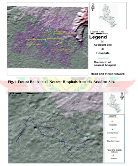
Fig. 1 Fastest Route to all Nearest Hospitals from the Accident Site.
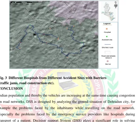
Fig. 3 Different Hospitals from Different Accident Sites with Barriers (traffic jams, road construction etc).
CONCLUSION
Indian population and thereby the vehicles are increasing at the same time causing congestion on road networks. DSS is designed by analyzing the ground situation of Dehradun city, for example the problems faced by the inhabitants while travelling on the road network. Especially the problems faced by the emergency service providers like hospitals during transport of a patient. Decision support System (DSS) plays a significant role in solving routing problem of an ambulance on the Dehradun road network when need arises to
transport a patient to the nearest hospital. DSS also analyses roads interrupted by the congestion and other activities during peak hours and calculates the fastest route. DSS is capable of handling multi-accident situation.
In this thesis every corner of the DSS system shows without GIS, we cannot analyze the problems faced by the ambulance on the road network. GIS-network analyst tools are used in our DSS to solve problems faced by ambulance. This thesis shows that how well GIS-based DSS will be used to send the routing information to the ambulance driver in real-time. This GIS/GPS integrated system can be used by other emergency service providers such as police and fire stations to locate their vehicles in densely congested roads. From result we have concluded that this prototype is working well but need further changes after getting into implementation stage in real world. This prototype is evaluated by the GIS-users and concluded that it is very useful for faster transportation of a vehicle considering the real ground situation but also there were some comments on
making it further effective by implementing it. Last but not the least; this DSS is useful in faster transport of an accident patient to nearest hospital.
ACKNOWLEDGEMENT:
Authors are thankful to Administration, Doon University for logistic support for the preparation of the manuscript.
References:
1. Boogere James (2008) “Decision Support System for Vehicle Scheduling in
Uganda: A Case Study of Gateway Bus Company”. A Project report submitted to School of Graduate Studies in partial fulfilment for the award of Master of Science in Computer Science Degree of Makerere University.
2. Devlin, Dr Ger (2010) “Decision Support System for Truck Route Modelling (D –
TRM)”, pp 169-186.
3. Imtiyaz Pasha (2006)“Ambulance Management System using GIS”, Department of Computer and Information Science, pp 1-78.
4. Irfan Ali Memom (2005) “Application of Geographic information System in Transportation for road Network Analysis”, pp 1-77.
5. Kai Han (2006) “Developing a GIS-based Decision Support System for Transportation
System Planning”, M.Sc., EIT, Department of Civil Engineering, University of Manitoba, pp 1-5.
7. Kevin Paul Scheibe (2003) “A Spatial Decision Support System for Planning Broadband, Fixed Wireless Telecommunication Networks”.
8. Marko Bohanec (2009) “What is Decision Support”. Department of Intelligent
Systems, pp1-4.
9. Nancy Echols (2003) “Finding the Fastest Route: A GIS Network Analysis Project”, pp1-15.
10. Peter Keenan (2008) “Modelling Vehicle Routing in GIS”. Department of
Management Information Systems, pp 201-218.
11. Reshmi Mukherjee (2008) “Using GIS-Based Network Analysis to Evaluate UNT E-Trans Buss Routes”.
12. R.Nijagunappa, Sulochana Shekhar, B.Gurungnanam, P.L.N.Raju and Prabir De (2007) “Road Network Analysis of Dehradun City using High Resolution
Satellite Data and GIS”. Department of studies and research in environmental
science, pp 267-274.
Yi-Hwa Wu, Harvey J. Miller and Ming-Chih Hung (2001) “A GIS Based Decision Support System for Analysis of Route Choice in Congested Urban Road Networks”.