Methodology of compositional assessment in the beech
vegetation zone and its application
Zamrzlová I., Doleželová D., Vacek O.
Department of Landscape Architecture, Faculty of Agrobiology and Natural Sciences,
Czech University of Life Sciences Prague, Prague, Czech Republic
Abstract
Zamrzlová I., Doleželová D., Vacek O. (2015): Methodology of compositional assessment in the beech veg-etation zone and its application. Hort. Sci. (Prague), 42: 159–166.
The visual impact of primary landscape is overwritten, historical references and spiritual ties to the current local popu-lation are losing. Rational planning and evaluation of the landscape must correspond to this situation. In the Czech Republic methodologies of landscape assessment (for its identification, typology) exist, but there is no finalizing mate-rial to specify procedures for creating landscape designs in accordance with a particular landscape type or vegetation zone. As a response, the new methodology of compositional preconditions assessment in the beech vegetation zone and the model etalon applying generally valid compositional principles on landscape designs were created. In a verification study the new methodology was applied in a specific micro region association – the Svidník. For the worst evaluated units proposals according to the model etalon has been prepared to highlight the characteristics of the appropriate vegetation zone.
Keywords: visual impact of landscape; landscape designs; compositional principles in landscape planning
At present, there is almost no landscape unaf-fected by human activities (Forman, Gordon 1986). Along with changes in behaviour of society different impacts on the landscape are visible (Bell 1999; Sádlo et al. 2008); related to this are increas-ing needs for landscape management to ensure its sustainable development (Weber 2007).
For an effective landscape planning it is firstly necessary to define values and characteristics of the landscape types – for the needs of this thesis alti-tudinal vegetation zone is understood as a “type”. The work is especially focused on beech vegeta-tion zone. According to Zlatník (1956) this zone represents 50.1% of the Czech Republic (hereafter CR), in altitudes from 400 to 700 m a.s.l., dominant geo-biocoenosis being beech woodland. Based on Culek et al. (1995) beech vegetation area is slightly smaller – 42.6% of the country. Contrary to these,
Štykar (2008) involves almost the entire territory of the CR to the natural range of Fagus sylvatica L. Beech vegetation zone thus forms one of the ba-sic constituents of the landscape in the CR and was chosen as a model for creation of the methodology of landscape compositional preconditions assess-ment with respect to the visual character of the landscape type.
Hepburn (1984) also says that the aesthetic per-ception of nature has an effect on the creation of human standards of beauty. This proves the need to include a visual and aesthetic impact of landscape on viewer to complex landscape modifications.
METHODS
The newly established methodology is based on the methods recommended by the Nature Conser-vation Agency of the Czech Republic for landscape character assessment and generally used categories for landscape character assessment in the Europe-an Union (methodologies mentioned by Wascher (2005)). In accordance with these the new method-ology is proceeded in logical steps: 1 – connection to broader territorial units, 2 – definition of solved spaces, 3 – evaluation of the compartments and 4 – the draft measure according to the model etal-on. The last step represents a finalizing material for landscape proposals which is currently lacking in the Czech Republic.
Compliance with higher planning levels within the methodology is ensured by the main compo-sitional axes (natural or cultural) that connect the solved micro region or cadastral municipality to the neighbouring territorial units. Compositional axes are supposed to be part of the planning analytical materials. The cultural axis links important cultural monuments and ensures that the region is passable, natural axis creates a set of natural habitat, connect-ing existconnect-ing protected areas or elements, territorial system of the ecological stability (TSES), etc.
As a basic component for assessment composi-tional units are delimited, defined by visual barriers in the area (natural and anthropogenic) and inner homogeneity. Inside the compositional units visual relationships of landscape elements are assessed. The relevant elements are defined from a
compari-son of the above-mentioned methodologies. The most common visually assessed elements are: re-lief, water features, urban structure, land use (mo-saic), vegetation, cultural and natural monuments. Bukáček and Culek (2009) define the spatial and functional relations for the evaluated elements. Vorel and Sklenička (2004) add time dimen-sion – past and present – to the relations. Relations between elements and their character determined the compositional potential of the assessed zones. In the new methodology the elements are specified to: relief, water features, urban structure, land use and landscape mosaic, configuration of vegetation elements in the landscape, the species composition of vegetation elements, protected areas and natural monuments, dominants and architectural elements in the landscape, cultural monuments, and scenery. By photographic documentation made in beech vegetation zone (defined by potential natural veg-etation and confronted with natural habitats in the CR) typical characteristics of preferred ele-ments within the chosen zone were obtained. On this basis, an evaluation table that assesses eight basic elements (categories) in 5 in detail described levels was created (I) – the most typical, 5 points, (V) – lacking the characteristics of the vegetation zone, 1 point. Table 1 shows descriptions of levels for a relief category.
In total, it is possible to assign 40 points (8 cat-egories per 5 points) for each unit. In case that any of the category cannot be assessed in the compo-sitional unit (e.g. there is no water element) the value is supplemented with the average result for the category in the whole studied territory math-ematically rounded to whole numbers.
Final assessment of compositional units:
[image:2.595.62.538.650.757.2]Group I – 40 to 36 points (at least 90% of maxi-mum) – areas of valuable and relevant character-istics of beech vegetation zone in most catego-ries. Areas particularly suitable for foundation of
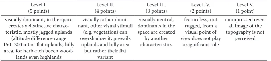
Table 1. Example of level description of characteristics for a category relief Level I.
(5 points) (4 points)Level II. (3 points)Level III. (2 points)Level IV. (1 point)Level V. visually dominant, in the space
creates a distinctive charac-teristic, mostly jagged uplands
(altitude difference range 150–300 m) or flat uplands, hilly
area, for herb-rich beech wood-lands even highwood-lands
visually rather domi-nant, other visual stimuli
(e.g. vegetation) can overshadow it, prevails
uplands and hilly area but rather their flat
variant
visually neutral, dominants in the space are created
by another characteristics
featureless, not rugged, from a visual point of view does not play
a significant role
unimpressed over-all image of the topography is not
national parks and significant landscape compo-nents and designing educational trails.
Group II – 35 to 28 points (at least 70% of maxi-mum) – areas with the majority of categories in corresponding parameters for the beech veg-etation zone. Interventions are not a necessity. Planned modifications focused on those catego-ries that obtained the least points. The territory has a potential to fully match the characteristics of beech vegetation zone after minor interven-tions.
Group III – 27 to 20 points (at least 50% of the maximum) – areas of average value in terms of compositional parameters of beech vegetation zone. In the categories that received more than half of possible points, adjustments are not im-mediately needed. Categories that are below this limit are necessary to modify according to the model etalon.
Group IV – 19 to 0 points (less than 50% of maxi-mum) – areas do not match the characteristics of beech vegetation zone. Here, landscape modifi-cations in accordance to the model etalon are a necessity for the most categories.
The results of evaluation (texts and maps) are con-ceived as part of local plans. In the map each group is coded with different colour – this representation allows a quick overview of compositional potential confronted with the intentions in the territory and makes it easier to decide where to finance and fi-nalize the landscape modifications is necessity and where maintenance or even no interventions can be considered as appropriate approach.
As a finalizing material the model etalon was cre-ated, which lists the use of general compositional principles for specific proposals of individual ele-ments modifications according to the character of the beech vegetation zone. On this basis it is pos-sible to draw up concrete proposals for the particu-lar compositional units that are precisely targeted to the problematic category and can change inad-equate characteristics to the desired form.
RESULTS AND DISCUSSION
For verification of the new methodology a con-crete bioregion was chosen (Culek et al. 1996) characterized by the same vegetation zone and mostly also by potential biota – suitable for the methodology) with a wider representation of
bio-chores (means more than average, ensures a diversi-ty in compositional units). As the most suitable the Pelhřimov bioregion was chosen and therein due to the size and functionality of the political units the Svidník micro region association. The Svidník association (the largest settlement is Černovice, located between the towns Pelhřimov and Tábor, situated in the Bohemian-Moravian Highlands) is active and functional and there is evident effort to take care and to ensure further development of the landscape, which is important for the possibility of promoting the proposed measures.
The main natural compositional axes indicate a potential connection of 3 natural monuments pre-sented in the micro region. The emphasis in the proposals for units which this axis goes through is put on ecology and biodiversity. The main cultural axis interconnects by proposed system of hiking trails cultural centres of micro region (Černovice, Obrataň, Věžná and Křeč) with historical and cul-tural monuments beyond boundaries of the solved micro region. Act No. 183:2006, on zoning and building code (Building Act), as amended, defines the tools for urban planning. Planning analytical materials were proved in the verification study as a useful source of information at the micro region scale and for the incorporation of the main compo-sitional axes as results of the methodology.
In accordance to Decree No. 500:2006, on ana-lytical materials for town planning, town planning documentation and method for filing town plan-ning activities, as amended, Míchal et al. (1999) defines a place and region of landscape character before actual assessment of the landscape. Löw and Míchal (2003) specify space according to the visual aspects and hierarchy as inner- and supe-rior visual units. Also the other authors (Vorel, Sklenička 2004) agree on the necessity of relevant landscape spaces delimitation before the assess-ment. The created methodology corresponds the most to the visual character of units’ definition that provides to be the most suitable for the needs of compositional evaluation of the territory.
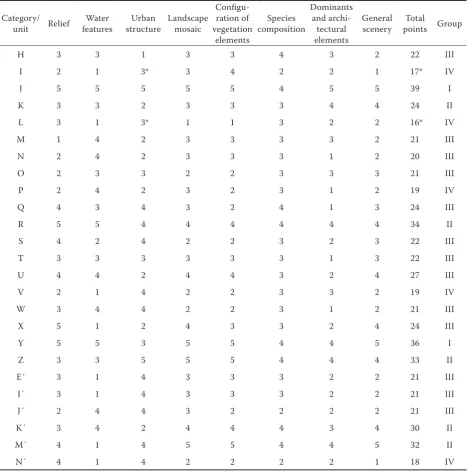
by potential vegetation). The results are summa-rized in Table 2. Text and map results of the units’ evaluation are compatible with the extent and scale of local plans.
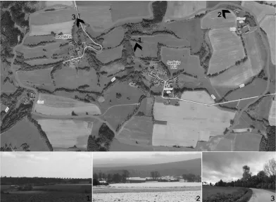
In the first group (the best evaluated areas) only 2 units (J and Y) were placed. The units convincingly fulfil characteristics of beech vegetation zone. That corresponds to Bukáček et al. (2008) who
[image:4.595.67.433.95.365.2]men-Fig. 2. The form of compositional unit J. The overall structure is composed by preserved scattered vegetation, the scale is pleasant and there are both cultural and natural values
[image:4.595.101.497.440.727.2]tion the need of special protection of the preserved historical land use between Bezděčín and Sudkův Důl (unit J) and a natural valley area with meadows around Černovický stream (unit Y) – described as a part of a region Pacovsko. Fig. 2 illustrates the ap-pearance of the compositional unit J. The relief is rugged, sloping down to the water stream with natu-rally formed vegetation. There are a few settlements; all have historically preserved silhouette and harmo-nious transition into the landscape. Compositional unit is richly structured by scattered vegetation into
[image:5.595.64.532.113.585.2]smaller spaces, which creates an adequate scale. The landscape is full of views, interesting and varied. The species composition of vegetation elements is rather diverse and meets the required specifications. The scenery is closed, graspable and comfortable to human scale. There are also historical and cultural values (elements of rural architecture, water fortress in Sudkův Důl). To the positively evaluated units, el-ements of nature protection are incorporated based on the Act No. 114:1992 on nature and landscape protection, as amended. As the most suitable seems Table 2. Evaluation of compositional units in the solved micro region
Category/
unit Relief featuresWater structureUrban Landscape mosaic
Configu-ration of vegetation
elements
Species composition
Dominants and
archi-tectural elements
General
scenery points GroupTotal
H 3 3 1 3 3 4 3 2 22 III
I 2 1 3* 3 4 2 2 1 17* IV
J 5 5 5 5 5 4 5 5 39 I
K 3 3 2 3 3 3 4 4 24 II
L 3 1 3* 1 1 3 2 2 16* IV
M 1 4 2 3 3 3 3 2 21 III
N 2 4 2 3 3 3 1 2 20 III
O 2 3 3 2 2 3 3 3 21 III
P 2 4 2 3 2 3 1 2 19 IV
Q 4 3 4 3 2 4 1 3 24 III
R 5 5 4 4 4 4 4 4 34 II
S 4 2 4 2 2 3 2 3 22 III
T 3 3 3 3 3 3 1 3 22 III
U 4 4 2 4 4 3 2 4 27 III
V 2 1 4 2 2 3 3 2 19 IV
W 3 4 4 2 2 3 1 2 21 III
X 5 1 2 4 3 3 2 4 24 III
Y 5 5 3 5 5 4 4 5 36 I
Z 3 3 5 5 5 4 4 4 33 II
E´ 3 1 4 3 3 3 2 2 21 III
I´ 3 1 4 3 3 3 2 2 21 III
J´ 2 4 4 3 2 2 2 2 21 III
K´ 3 4 2 4 4 4 3 4 30 II
M´ 4 1 4 5 5 4 4 5 32 II
N´ 4 1 4 2 2 2 2 1 18 IV
the institute of significant landscape components, which is currently under-exploited according to Salašová (2009).
The second group consists of four units. These units meet the desired characteristics in the most categories. Most of the units (14) fall within the third group - an average value. By using the new methodology it is possible to define more accurate-ly the problematic parts of these units and the pro-posals can be easily focused on them (elements with the lowest points gained). This will lead to more ef-fective funds spent on landscaping while achieving the maximum effect, which corresponds to Maas et al. (2012), who claim that due to the continuing crisis the global trend is to focus on proposals cost effectiveness and their sustainability.
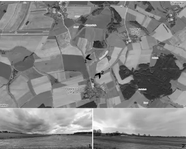
Four units have received less than half of the pos-sible points (group IV). These units almost do not indicate the appropriate vegetation zone. Fig. 3 shows one of the worst units – unit P. This unit far less visually corresponds to the desired character-istics. The relief is rather flat. The only watercourse in the unit is artificially modified. A silhouette of
the settlement is disrupted by oversized buildings of an agricultural cooperative. The overwhelming majority of the area consists of arable land, which is not divided by vegetation elements. Unit is de-serted and empty, without any visible dominant, historical, architectonic or natural values.
Comparison of the results for all of the units with other authors is not possible, because this method-ology is a prototype with unique results. Generally the landscape assessment is focused on wider ter-ritories or concrete intentions.
[image:6.595.105.489.95.402.2]Fig. 4. Scheme of landscape proposals for unit P in ac-cordance with the model etalon – smaller scale of the landscape created by scattered vegetation, revitaliza-tion of the stream and “shield” vegetarevitaliza-tion for smoother transition of the agricultural cooperative to landscape
tion to the local elements of a territorial system of ecological stability (not yet defined in local plans). Hedgerows are designed to highlight verticals by utilization of illusion. Further revitalization of the watercourse is proposed as well as its completion by suitable vegetation. Near the settlement “shield” greenery is complemented around the buildings of an agricultural cooperative to soften and integrate the silhouette. For both vegetation elements prin-ciple of repetition is used to incorporate them into the landscape. Species composition in the proposal corresponds to the natural potential vegetation. Vegetation elements provide the division of the compositional unit into smaller spaces, which will be more easily understood and visually more inter-esting for the viewer. The model also highlights the necessity to combine the functions of proposed el-ements. In the proposals especially a combination of supplement of scattered vegetation with design-ing TSES is used, which is consistent with Löw (1995), who points out that planning TSES should also ensure, inter alia: “Socially tolerable form of relationships preservation that existed in the land-scape and sustainable development in the country-side should be preserved or restored.” The proposal for unit P is completed by the creation of a tourist
route, which both makes the proposed adjustments available to the visitor and also connects compo-sitional unit with the broader neighbourhood. All the proposed vegetation elements are planned with respect to composition, historical, ecological and economic functions of the landscape. A scheme of the proposed solution is shown in Fig. 4.
CONCLUSION
The connection of the new methodology to the existing process of urban planning is a necessity, therefore it is tied with planning analytical mate-rials (the compositional axis) and local plans (de-limitation of the composition units and their evalu-ation, specification of specially protected areas or elements are planned as part of a regulatory plan extended on landscape). Even now, there is already a base for the need of the methodology, where it would be effortlessly possible to integrate back-ground materials for essential analysis and the re-sults of the compositional potential assessment. In the model area system was this proved to be realis-tically applicable.
Defining of relevant elements for evaluation based on the used methodologies was also proved as ap-propriate. The problem is an objective characteri-zation of each level of categories to ensure achieve-ment of the same results when assessing by different experts. Very clear and precise formulations of the scoreboard are essential. The methodology repre-sents a professional tool that requires knowledge of the historical development of the landscape, of the urban structure of settlements, dendrology and phy-tosociology. The methodology is therefore intended for professionals, landscape architects, who will be-come an irreplaceable part of the planning process of landscape plans creations.
References
Bell S. (1999): Landscape, Pattern, Perception and Process. London, E & FN Spon.
Boqué J., Sala P. (2006): Prototype landscape catalogue: conceptual, methodological and procedural bases for the preparation of the Catalan Landscape Catalogues. Available at http://www.catpaisatge.net/eng/publicacions_colec-cions.php (accessed May 5, 2012).
Boucníková E., Fanta J., Líšková Z. (2006): Úloha krajinného plánování v systémovém řízení vývoje a využívání krajiny. In: Dreslerová J., Packová P. (eds): Ekologie krajiny a kra-jinné plánování, sborník ekologie krajiny 2, Proceedings from CZ-Iale, Sept 14–16., 2006, Lednice. Kostelec nad Černými lesy, Lesnická práce s.r.o.
Bukáček R., Bukáčková P., Culek M., Matějka P., Chroust J., Rusňák J. (2008): Strategie ochrany krajinného rázu kraje Vysočina. Available at http://extranet.kr-vysocina. cz/download/ozp/strategie_kraj_raz/C_Oblasti_a_mista. pdf (accessed Nov 18, 2014).
Bukáček R., Culek M. (2009): Vymezování oblastí a míst kra-jinného rázu a jejich charakterizace pro potřeby územního plánování. In: Vorel I., Kupka J. (eds): Aktuální otázky ochrany krajinného rázu. Conference proceedings, Feb 12, 2009, Prague, Czech Technical University in Prague. Culek M., Grulich V., Povolný D. (1996): Biogeografické
členění České Republiky. Prague, Enigma.
Forman R.T.T., Gordon M. (1986): Landscape Ecology. New York, John Wiley & Sons.
Hepburn R.W. (1984): Wonder and other essays – Eight Studies in Aesthetics and Neighbouring Fields. Edinburgh, Edinburgh University Press.
Löw J. (1995): Rukověť projektanta místního územního systému ekologické stability: metodika pro zpracování dokumentace. Brno, Doplněk.
Löw J., Míchal I. (2003). Krajinný ráz. Kostelec nad Černými lesy, Lesnická práce, s.r.o.
Luginbühl Y. (2006): Indicadors de paisatge, repetes i pe-spectives, places de paisatge. Available at http://www.cat-paisatge.net/eng/publicacions_coleccions.php (accessed March 17, 2012).
Maas R., Kruitwagen S., van Gerwen O.-J. (2012): Environ-mental policy evaluation: Experiences in the Netherlands. Environmental Development, 1: 67–68.
Míchal I. et al. (1999): Hodnocení krajinného rázu a jeho uplatňování ve veřejné správě. Prague, Agentura ochrany přírody a krajiny. Available at http://old.ochranaprirody.cz/ res/data/134/017959.pdf (accessed Apr 5, 2012).
Salašová A. (2009): Vybrané problémy posuzování krajinného rázu z hlediska potřeb územního plánování. In: Vorel I., Kupka J. (eds): Aktuální otázky ochrany krajinného rázu. Conference proceedings, Feb 12, 2009. Prague, Czech Technical University in Prague.
Sádlo J., Pokorný P., Hájek P., Dreslerová D., Cílek V. (2008): Krajina a revoluce – významné přelomy ve vývoji kulturní krajiny Českých zemí. 3rd Ed. Prague, Malá Skála.
Štykar, J. (2008): Lesnická fytocenologie a typologie. Brno, Mendel University in Brno.
Vorel I., Sklenička P. (2004): Posouzení vlivu navrhované stavby, činnosti nebo změny využití území na krajinný ráz. Prague, Czech Technical University in Prague.
Wascher D.M. (2005): European landscape character areas – typologies, cartography and indicators for the assessment of sustainable landscapes. Final project report as deliver-able from the EU’s accompanying measure project Euro-pean Landscape Character Assessment Initiative (ELCAI), funded under the 5th Framework on Energy. Environment
and Sustainable Development (4.2.2). Oxford, Printing Press. Available at http://edepot.wur.nl/1778 (accessed Sept 17, 2014).
Weber M. (2007): Evropská úmluva o krajině a možnosti její implementace v oblasti koncepčních a plánovacíh nástrojů pro realizaci krajinných politik.Urbanismus a územní rozvoj, X: 43–46.
Zlatník A. (1956): Nástin lesnické typologie na biogeoce-nologickém základě a rozlišení československých lesů podle skupin lesních typů. Pěstění lesů III.Prague, Státní zemědělské nakladatelství.
Received for publication November 23, 2014 Accepted after corrections March 18, 2015
Corresponding author: