Past, current and future of Japanese national program for earthquake
prediction research
Naoshi Hirata
The Earthquake Research Institute, The University of Tokyo, 1-1-1 Yayoi, Bunkyo, Tokyo 113-0032, Japan
(Received December 11, 2003; Revised August 8, 2004; Accepted August 9, 2004)
The Japanese national earthquake prediction program started in 1962 with a blue print for the scope and direction of research to follow. Substantial time and efforts were subsequently devoted to the construction of new observation networks and the study on the earthquake generation mechanisms. An important result has been the recognition of the great difficulty in identifying creditable precursors due to a diversity of earthquake generation process. In recent years, a new age of near real time observations of Earth’s crustal processes by dense arrays of seismic and the GPS (Global Positioning System) stations has arrived. The results of the real time monitoring may lead to a new approach in the earthquake prediction research, i.e., the quantitative forecasting of the crustal activities. The new national program, which inherits its essential observational network from all the previous programs, emphasizes the importance of modeling as well as monitoring for a sound scientific development of earthquake prediction research.
Key words:Earthquake prediction, national program, quantitative forecast, the blue print, asperity.
1.
Introduction
National earthquake prediction research program in Japan started in 1962 with a blue print for the scope and direction of research to follow. It was carried out from 1965 to 1999 in succession of the 1st to 7th 5-year program, although the first 5-year program was cut short to 4 year-period for the reason explained later. The 7th program underwent an exten-sive review because of the damaging Hanshin/Awaji Earth-quake, which we call the 1995 Hyogo-ken Nanbu (Kobe) earthquake, that occurred in January 1995, and for the prepa-ration of “The new Program of Research and Observation for Earthquake Prediction” (hereinafter called the new 5-year program) which started in 1999. In March 2004, this pro-gram is completed. Internal and external evaluations of the 1st new 5-year program were made in 2002. “The 2nd new Program of Research and Observation for Earthquake Pre-diction” (hereinafter called the 2nd new 5-year program) is in place in 2004.
In the new program greater importance is attached to the fundamental study beyond the traditional study of precursory phenomena. The old programs ranging from the 1st to the 7th accumulated much knowledge regarding the basic char-acteristics of earthquake activities, such as sites where quakes occur, mechanisms of the occurrence of the earth-quakes, etc. On the other hand, it has been recognized that the usual target of earthquake prediction, namely when (time), where (place), and how large (magnitude) an earth-quake will occur, is in general exceedingly difficult to at-tain. The traditional empirical approach based on the obser-vation of the precursor phenomena of an earthquake could not achieve the goal owing to the complexity of earthquake
Copy right cThe Society of Geomagnetism and Earth, Planetary and Space Sciences (SGEPSS); The Seismological Society of Japan; The Volcanological Society of Japan; The Geodetic Society of Japan; The Japanese Society for Planetary Sciences; TERRA-PUB.
phenomena. In the new program that started in 1999, it was intended to modify the approach in a fundamental way. This paper describes an outline of the past and new national earth-quake prediction research programs in Japan.
2.
The Blue Print and the First National
Earth-quake Prediction Programs (1965–1998)
The national earthquake prediction research program in Japan started with publication of a document entitled Pre-diction of Earthquakes—Progress to Date and Plans for Fur-ther Development(usually referred to as theblueprint; Earth-quake Prediction Research Group, 1962). This became the foundation of the earthquake prediction research that led to the establishment of an observation system to collect basic data for earthquake prediction research. By the completion of the 2nd 5-year program (1969 to 1973), the basic structure of today’s observation system for earthquake prediction was formed. By the end of the 3rd 5-year program, the opera-tion of the observaopera-tion system was improved and diversified. During the 3rd program specific areas of intensified research, such as the Tokai region were assigned.In theblueprint, it was expected that a large earthquake may be predictable if we understood and were able to capture an anomalous crustal deformation as a precursor of a large earthquake or anomalous seismicity increase as foreshocks. Thus, a plan was made to monitor the crustal deformation and the seismicity in the entire Japan.
During that time, seismology was at the stage before the general acceptance of plate tectonics as well as of the fault model as the earthquake source. We did not have even a working hypothesis on the process through which an earth-quake would occur in the crust. Under the circumstance, the concerned seismologists were ambitious enough to pro-pose an empirical and experiential observation plan for earth-quake prediction with a hope that it will give a better
derstanding of the phenomena leading to the occurrence of a major earthquake. This proposal must be highly evalu-ated in view of the fact that, since that time on, the program greatly contributed to the progress of the understanding on earthquake occurrences. In theblueprint, a statement was made that we could answer the question of the earthquake predictability in 10 years after the start of the national pro-gram. However even today after 40 years, we still cannot state with sufficient certainty when an effective forewarn-ing service will be available. We may say that the prospect was too optimistic from a viewpoint of the present knowl-edge of earthquakes and crustal structures. That is to say, the structure and process in the Earth’s crust are much more complicated than hoped in those days, and the sites for ob-servations are too coarsely located to detect a systematic re-lationship between the crustal deformation, seismicity, and large earthquakes. Furthermore, styles of anomalous phe-nomena (precursor phephe-nomena) before occurrence of large earthquakes are exceedingly complicated and diversified in-cluding no precursor for some large earthquakes. Thus, it takes so much time to understand the mechanisms of the ap-pearance of the phenomena by synthesizing the accumulated examples.
In the first 5-year program that started in 1965, it was intended that an observation system to collect various geo-physical and geochemical data needed for earthquake pre-diction would be completed in nationwide scale within 10 years (Geodesy Council, 1964). But this was not accom-plished, because during this period, the Matsushiro Earth-quake Swarm (1965–1970) reached its peak in the spring of 1966 and several damaging earthquakes including the 1968 off-Tokachi Earthquake (M7.9) occurred. As a result, social demand for earthquake prediction became strong, and for a greater emphasis on practical utilization of the prediction as a target, the 1st program was terminated after 4 years and transferred to the 2nd earthquake prediction program.
The 2nd 5-year prediction program formed the backbone of the present-day organization scheme for earthquake pre-diction (Geodesy Council, 1968). This began with the es-tablishing ofthe Coordinate Committee for Earthquake Pre-diction (CCEP)in 1969 to help information exchange con-cerning earthquake prediction as well as to make compre-hensive judgment of the information. In 1970the Areas for Special Observationandthe Areas for Intensified Observa-tionwere designated for reinforcement of the observation re-search. Around that time, the concept of seismic gap pointed out a high possibility of earthquakes occurring in the Tokai area and offshore of the Nemuro Peninsula. The 1973 off-Nemuro Peninsula earthquake (M7.4) occurred in the area expected from the gap theory (Utsu, 1972).
The 3rd 5-year program promoted new observation meth-ods, including telemetry of seismic observation, deep bore-hole measurement in Tokyo Metropolitan area, cable-type ocean bottom seismographs off the cape Omaezaki, Tokai area, and bury-in type volumetric strainmeters in Tokai and southern Kanto areas, etc. (Geodesy Council, 1973). The telemetry system of the seismic networks improved the de-tectability of microearthquake and the accuracy of hypocen-ter dehypocen-termination, which resulted in revealing the double-planed structure of a deep seismic zone in the Kanto and
To-hoku regions (Tsumura, 1973; Hasegwaet al., 1978). Thus, the strengthening of the earthquake prediction scheme was concentrated onthe Kanto-Tokai Areas for Intensified Ob-servation. In that period, the 1975 Haicheng, China, earth-quake (M7.3) was successfully predicted using various ob-servations including prominent foreshock activities. Issuing an order for evacuation enabled to save lives of many peo-ple. However, in the case of the 1976 Tanshang, China, earthquake (M7.8), imminent prediction was unsuccessful, resulting in a loss of many lives. In Japan, reinforcement of the program was twice motivated by the prominent seismic activities in and around the Izu Peninsula starting in 1974. In 1976 the “Tokai earthquake hypothesis” went public, which claimed that the focal area of an anticipated earthquake in Tokai area was likely to extend deep into the Suruga Bay (Ishibashi, 1981). A “Prediction Council for the Tokai Area” was established in the CCEP in 1977, and a “Large-scale Countermeasures Act” was enforced in 1978. The 1978 Izu-Oshima-kinkai earthquake (M7.0) occurred in the area cov-ered by such a reinforced observation network, enabling ob-servations of not only remarkable foreshocks but also possi-bly precursory anomalies in crustal strain, radon concentra-tion in the groundwater, and the underground water level at several monitoring stations (Wakitaet al., 1980).
The 4th 5-year program (1979 to 1983) emphasized the “techniques for long- and short-term prediction” (Geodesy Council, 1978). That is to say, based on the “technique of long-term prediction” to predict a “place” and “magnitude”, it was emphasized to establish a “technique for short-term prediction” that seeks the “time” of occurrence of earth-quakes, i.e. detection of the precursor phenomena and un-derstanding what was really going on before the earthquake. During the program, progress was made in the measurement of the strain distribution over Japanese Island, data exchange method among microearthquake observation networks, auto-matic processing of the seismic data, and cable-type ocean-bottom seismometers.
In 1979, with the designation of the Tokai area as an “Area under Intensified Measures against Earthquake Disaster”,
the Prediction Council for the Tokai Areain theCCEPwas dissolved and replaced by a new “Prediction Council for Ar-eas under Intensified MAr-easures against Earthquake Disas-ter” at the Meteorological Agency, reinforcing the existing scheme for continuous monitoring in the Tokai area.
The 5th 5-year program (1984 to 1988) further improved the observation research mainly inthe Areas for Intensified Observation, i.e., the Kanto-Tokai area and the Areas for Special Observation (Geodesy Council, 1983). Based on the idea of the long-term and short-term prediction, a va-riety of observations with improved quality and density as well as a comprehensive analysis of precursory data from various viewpoints were made in this period. It was reported that the 1983 central Japan Sea earthquake (M7.7) was as-sociated with precursory seismicity and crustal deformation (e.g., Mogi, 1986).
In the 6th 5-year program (1989 to 1993), a basic study on inland earthquakes started because little was known about the generation mechanism of earthquakes away from plate
boundaries (Geodesy Council, 1988). By the period of
seis-mic networks developed by universities revealed large-scale three-dimensional seismic velocity structures, and then the relationship between velocity distribution and thermal struc-ture, such as the distribution of volcanoes, was clarified (Hi-rahara, 1981; Hasegawaet al., 1991). Thus, the detailed seis-mic structure in a scale comparable to a seismogenic fault be-came a target of the study. The research on the 1984 Nagano-ken seibu (western Nagano prefecture) earthquake (M6.8) started during the 5th 5-year program and continued in the 6th 5-year program. It was intended to understand the swarm activities and the mainshock-aftershock activity which oc-curred in the same area. This is the first joint observation for the inland earthquake by many institutions with modern in-struments including seismic, geodetic, gravity measurements (e.g., Horiuchiet al., 1992; Hiraharaet al., 1992; Kasayaet al., 2002). In the later 5-year programs, the joint observa-tions, where many institutions jointed with their instruments and sheared the data, were conducted several times; in the area of Japanese Alps in central Honshu (e.g., Matsubaraet al., 2000), Nikko area in northeastern Honshu (Horiuchiet al., 1997), Tohoku area in northeastern Honshu (e.g., Naka-jimaet al., 2001), Hokkaido (Katsumataet al., 2003), and southwestern Honshu, Japan. Some relationships between the heterogeneous structure of the crust, such as the seismic wave velocity distribution or electric resistivity distribution, and the distribution of microearthquakes were revealed (eg., Hiraharaet al., 1992; Kasayaet al., 2001) .
Enhancement of survey technology of crustal deformation using space-based technology was achieved to increase in its efficiency: the Geographical Survey Institute, Japan, started to install the Global Positioning System (GPS) network in 1990. The GPS network enabled a continuous monitoring on crustal deformation with an accuracy of 10−7or better at a baseline length of 100 km.
The 7th 5-year program (1994 to 1998) started to aim at evaluation of the earthquake potential in addition to the tech-niques of the long-term and short-term prediction (Geodesy Council, 1993). That is to say, we tried to identify the present moment in relation to the regional earthquake cycle. For this purpose we had to understand the regional stress field, which is caused by relative plate motions to make large earthquakes along plate boundaries and/or inland areas.
To know the earthquake cycle, past histories of seismicity was investigated by paleo-seismology based on written his-torical records, an excavation survey, geomorphologic and geological investigations. As a result, the interval between the consecutive major earthquakes which occurred repeat-edly in the individual faults has been estimated. If the time of the last major earthquake on the fault is known, the prob-ability of the occurrence of an earthquake at present can be evaluated using a statistical model of the recurrence interval. If we can put simple physics we may improve the probability evaluation. For example, the time predictable model (Shi-mazaki and Nakata, 1980) would imply a longer recurrence time than average after the occurrence of an earthquake with a slip greater than the average because it takes longer time to accumulate the strain after a larger slip assuming a con-stant rate of strain accumulation. The research strategy based on such a physical model will be much more emphasized in the new 5-year program by which we think that earthquake
occurrence forecast may be realized by understanding the whole processes in the Earth’s crust leading to a large earth-quake.
When the 7th 5-year program started, the October, 1994 Hokkaido Toho-oki earthquake (M8.2) and the December, 1994 Sanriku Haruka-oki earthquake (M7.6) occurred. In January 1995, the Hyogo-ken Nanbu (Kobe) earthquake (M7.3) occurred. Especially in the Hyogo-ken Nanbu (Kobe) earthquake, more than 6,000 human lives were lost and tremendous disaster struck the regions of Hanshin and Awaji. Motivated by this earthquake, the 7th 5-year program was re-examined in April 1995 and the observational research aim-ing to the evaluation on the earthquake occurrence poten-tialand the survey research concerning active faults was in-tensified. Furthermore in June 1995, an Earthquake Dis-aster Countermeasures Actwas enacted accompanied with the establishment of theHeadquarters for Earthquake Re-search Promotion. During the period of the 7th program, GPS observation networks were promoted to cover the en-tire Japanese Islands with a station spacing of a few tens of kilometers, which has been completed later as GEONET as discussed in the following section.
The focal area of the 1995 Hyogoken-nanbu (Kobe) earth-quake was covered with a dense seismic network to clarify the aftershock activity (Hirata et al., 1996). The network consisted of two local permanent networks and one tempo-rary network, which were connected by the Internet link. The Internet Protocol (IP) technology was used for the first time in field data acquisition and is widely used in the current data transfer method. The system was improved to use a satellite communication system for a nation-wide seismic telemetry (Urabeet al., 1998).
3.
The New Program of Research and Observation
for Earthquake Prediction and the Basic
Earth-quake Survey and Observation Plan
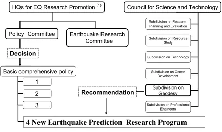
In the new 5-year program of research and observation for earthquake prediction (referred to as the first new 5-year pro-gram; 1999 to 2003), the earthquake prediction program was reformed to put more emphasis on the fundamental study beyond the traditional study of precursory phenomena. In the mean time, the Headquarters for Earthquake Research Promotionpublished a document entitledthe Promotion of Earthquake Research—Basic comprehensive policy for the promotion of earthquake observations, measurements, sur-veys and research(hereafter referred to asthe Basic compre-hensive policy; Headquarters for Earthquake Research Pro-motion, 1997). Before describing details of the first new 5-year program, we shall summarize the content ofthe Basic comprehensive policy.
Inthe Basic comprehensive policy, tasks with top priori-ties are listed in Chapter 3 as follows.
1) Preparation of a nationwide seismic hazard map inte-grating results of surveys of active faults, long-term as-sessment of the probability of earthquake occurrence, and prediction of strong ground motion
Subdivision on Research Planning and Evaluation Subdivision on Resource
Study Subdivision on Technology
Subdivision on Ocean Development
Subdivision on Professional Engineers
Subdivision on Geodesy
4 New Earthquake Prediction Research Program
Recommendation
Policy Committee
HQs for EQ Research Promotion
(1)Earthquake Research
Committee
1
2
3
Basic comprehensive policy
Council for Science and Technology
(1) Headquarters for Earthquake Research Promotion
Decision
Fig. 1. Organizational schemes for promotion of earthquake research. The headquarters for Earthquake Research Promotion determines theBasic comprehensive policy, which defines the tasks with top priorities including the earthquake prediction research program. The other three items from 1 to 3 are: 1. Preparation of a nationwide seismic hazard map integrating results of surveys of active faults, long-term assessment of the probability of earthquake occurrence, and prediction of strong ground motion, 2. Promotion of real-time transmission of earthquake information, 3. Improvement of the monitoring system in and around thearea under Intensified Measures against Earthquake Disaster defined by the Large-Scale Earthquake Countermeasures Act. The earthquake prediction research program is also recommended by the subdivision on Geodesy in the Council for Science and Technology, which reflects the opinion of the scientific community in bottom-up way.
3) Improvement of the monitoring system in and around
the area under Intensified Measures against Earthquake Disaster determined by the Large-Scale Earthquake Countermeasures Act
4) Promotion of research and observation for earthquake prediction
The new program of research for earthquake prediction has two positions: One is a research plan recommended bythe Geodesy Council, Japan, which is now a subdivision ofthe Council for Science and Technology, Japan, and the other is a task with priority for earthquake disaster prevention mea-sures (Fig. 1). The former has a function to reflect opinions of the science community in bottom-up way, which is impor-tant to make a scientifically sound plan. The latter is deter-mined in a top-down way, which may be good for funding.
To realize the above four tasks, theBasic comprehensive policydefines the following five items as the Basic Earth-quake Survey and Observation(Headquarters for Earthquake Research Promotion, 1999):
(1) Seismic observation by an array of high-sensitivity seismometers (microearthquake observation).
(2) Seismic observation by an array of broad-band seis-mometers.
(3) Strong ground motion observation.
(4) Observation of crustal deformation (continuous GPS observation).
(5) Active fault survey in coastal and inland regions. The ultimate goal ofthe Basic Earthquake Survey and Ob-servationis the mitigation of earthquake disaster by perform-ing the four tasks listed above, and will be achieved through: 1. Evaluation of the possibility of the long-term earthquake occurrence. 2. Understanding and evaluation of the present state of the crustal activities. 3. Prediction of the strong ground motion and tsunami. 4. Formulation of procedure for real-time transfer of the earthquake information to pub-lic, which are the direct purposes of the above five items.
al-between
Asperity
Plate of Jap
anese Island
Oceanic Plate
Aseismic Slip
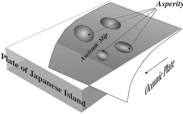
Fig. 2. Asperity model for a subduction plate boundary. The model explains the repeatability of the earthquakes by assuming a patch, called an asperity, on a plate boundary. The asperity is locked in an inter-seismic period and breaks to slip during an earthquake. Outside the asperity the plates are smoothly slipping.
ready far exceed the scope envisioned inthe 1962 blueprint.
4.
The First New 5-year Program (1999 to 2003)
Prior to the start of the first new 5-year program, the earth-quake prediction research was primarily based on the em-pirical approach to catch creditable precursors, which must be robust. This view was too rigid to allow the inherent variability in the precursory phenomena depending on the phase of the regional earthquake cycle and also on physical and/or chemical conditions in the crust. To put the earth-quake prediction research on a more flexible and scientifi-cally sound foundation, it is essential to recognize the im-portance of modeling of the earthquake process in addition to monitoring. In the first new 5-year program, various mod-eling approaches were introduced. For example, based on the well-established fault model of earthquake, how the tectonic stress transfer due to the slip of a past earthquake affects the future occurrence of earthquakes in its vicinity was investi-gated (e.g., Hashimoto and Matsu’ura, 2000).
Another example is the “asperity” model, which is used to explain the recurrent earthquakes (Matsuzawaet al., 2002; Yamanaka and Kikuchi, 2004). The model explains the re-peatability of the earthquakes by assuming a patch, called an asperity, on a plate boundary. The asperity is locked in an inter-seismic period and breaks to slip during an earth-quake. Outside the asperity the plates are smoothly slipping. A focal area consists of either single or several asperities. If an asperity for a small size earthquake is isolated as to have no interaction among asperities, the recurrence of the earth-quake may be regular because the rate of stress concentration is controlled mainly by the plate motion. If the strength of the asperity remains constant for a period of concern, say several hundreds of years, then the recurrence period is constant. This is the case of the repeating earthquakes observed off Sanriku (Matsuzawaet al., 2002). A large earthquake, which consists of more than one asperities, can be large or small depending on how many asperities are broken at once (Ya-manaka and Kikuchi, 2004). However, it is not clear so far
pat-tern and explain the diverse preparation process leading to the earthquake occurrence (Iioet al., 2003). We now further develop the concept of the asperity to establish a quantitative physical model. Another important finding is the deep non-volcanic tremor in southwest Japan, which is also correlated to the crustal deformation detected by a tilt meter, suggest-ing a close relation to the subduction of the Philippine Sea plate (Obara, 2002). The observation of the deep tremor may bring us an insight about the detailed physical and chemical process undergoing on the plate boundary.
While the permanence of asperities is encouraging for modeling the tectonic stress for inter-plate earthquake, the preparation process of an intra-plate inland earthquake be-gins to be understood in terms of the heterogeneous structure of the crust. The 2000 Tottori Prefecture earthquake (M7.3) occurred in a region that was considered less strained accord-ing to the present day observation by the GPS array. There was also no clear active fault in the region estimated by ge-omorphological and geological surveys. Clearly we would first need to clarify the heterogeneity of the crust and the up-per mantle with sufficient spatial resolution to understand the mechanism of concentration of stress on the fault zone.
The first new 5-year program includes also construction of simulation models for regional earthquake cycle using the finite-element method (e.g., Hyodo and Hirahara, 2003). A simultaneous study of both seismogenic structure and earth-quake process promoted in the new program hopefully leads to a unified model that can explain the mechanism in which the stress generated on the plate boundary is transferred to the crust away from the plate boundary and become concen-trated around a specific fault resulting in the occurrence of large earthquakes.
5.
The 2nd New 5-year Program of Research and
Observation for Earthquake Prediction (2004 to
2008)
The next 5-year program consists of the items as shown below (Council for Science and Technology, 2003).
(1) Study of the processes in the earth’s crust leading to major earthquakes
The program shall promote the observational, experimtal, and theoretical study to understand the process of an en-tire regional seismic cycle leading to major earthquakes. It is intended to incorporate all the observable phenomena includ-ing precursors in quantitative models based on the universal laws of physics and chemistry. The following 4 items will receive special attention.
(1-1)Long-term large scale crustal activity
We shall precisely determine configurations and position of the plate boundaries and relative motion of the plates con-stituting the Japanese island-arc and its surrounding regions in order to estimate precisely the arc-scale regional stress field and, in particular, to understand the origin of the belt, such as the Niigata-Kobe strained belt (Sagiyaet al., 2000), where crustal deformation is concentrated. We shall obtain the relative velocity of the plate motion at an accuracy of approximately 1 mm/year in and around Japan. We shall evaluate the roles of the proposed North American, Eurasian, Okhotsk, and Amurian Plates to the earthquake preparation process.
(1.2)Preparation or Imminent processes in the crust lead-ing to large earthquakes
The crustal activities from the preparatory stage to earth-quake occurrence will be explained as a series of the pro-cesses of stress concentration from the plate-driving forces to seismogenic faults. Experimental and observational stud-ies on detection and understanding of the irreversible phys-ical and chemphys-ical processes immediately before earthquake occurrence shall be promoted. The regularity and fluctuation of the regional earthquake cycle shall be studied not only by a statistical model but also by a physical model. The per-manence and universality of the asperity model will be im-portant targets of the study. Since, so far, all the proposed asperities are off-shore, it is important to promote the obser-vation in the offshore region.
(1.3) Focal processes and generation of strong ground motions
A detailed focal process of large earthquakes shall be stud-ied by the analysis of strong ground motions to identify the areas, which may be related to the asperity(s), on the fault from which the strong seismic energy was released. Char-acterizations of the asperities, the direction and the speed of the rupture propagation, and the change of the stress on the fault due to earthquakes are also necessary for understand-ing the focal processes. The permanence of the asperity is particularly relevant to the prediction of the strong ground motion during future earthquakes. Thus, the item 1.2 is di-rectly related to the item 1.3. Furthermore, a detailed crustal and basement structures should be clarified for strong ground motion prediction.
(1.4)Elemental processes of earthquake generation
We need experimental and theoretical studies on rock me-chanics and physical properties at high temperatures and pressures to understand the relationship between geophysi-cal parameters observed in the field study, such as the dis-tributions of seismic velocities and electrical resistivities in the crust, and physical properties of rocks in the crust and mantle, and a frictional and constitutive law on faults.
(2) Development of the predictive simulation models and monitoring system for the crustal activity
By comparing the observed crustal deformation data with the model simulation, we may gain better understanding in real-time crustal deformation that will help us to predict its future.
In the 1st new 5-year program, we developed a method of predictive simulation on crustal dynamics, and completed a prototype model for a specific area (e.g., Hashimoto and Matsu’ra, 2000; Hyodo and Hirahara, 2003). In the 2nd new 5-year program, we shall aim at forecast of the observ-able crustal activities on the basis of monitored data such as crustal deformation and seismicity in real time, by making a more realistic regional model for a specific area.
Development of integrated database for information of the crustal activity is an important item in the 2nd new 5-year program because the construction of a successful simulation model requires frequent renewals of the database for the monitored crustal activities.
(3) Development of new observational and experimental technology
crustal phenomena, we need to develop new observational and experimental technologies. In particular, we need to de-velop a method to monitor a crustal deformation at sea bot-tom to practical use. The 2nd new 5-year program empha-sizes the development and improvement of the various types of observation technology on the ocean bottom, the down-hole measurement technology, and the technology to moni-tor the change in subsurface structure and state. Enhanced utilization of space technology is also emphasized.
6.
Conclusions
The ultimate goal of the earthquake prediction research is to tell when, where, and how large an earthquake will occur. We shall approach this goal by understanding of the dynamic process in the Earth’s crust through monitoring and model-ing. This system will not only grasp the state of the crust leading to an earthquake with simulation of the temporal variation of the crustal activities, but also predict the strong ground motion generated by the expected earthquakes.
Thus, the 2nd new 5-year program emphasizes the impor-tance of modeling as well as monitoring for a sound scientific development of earthquake prediction research. Of course, it inherits its essential observational network from all the previous programs. The development of a predictive sim-ulation model was taken in as an important element of the program, because any physical understanding of a process needs a model to which universal laws of physics and chem-istry can be applied. There has been an apprehension that it may be premature to adopt such a strategy now, but we feel that the time is ripe for this truly scientific approach to earthquake prediction in Japan, where an excellent monitor-ing system has been established through the 40-year effort.
Acknowledgments. This work is partly supported by the grant for the earthquake prediction research program funded by the Ministry of Education, Culture, Sports, Science, and Technology, and Grant-in-Aid for Special Purposes (12800007). Discussion with mem-bers ofthe planning committee of the Coordinate Committee of the Earthquake Prediction Research in Japanese Universitiesis help-ful. Seiya Uyeda and Keiiti Aki gave me many suggestions, which improved the manuscript very much.
References
Council for Science and Technology, On the Promotion of the Second new Program of Research and Observation for Earthquake Prediction (Rec-ommendation), 2003 (in Japanese).
Earthquake Prediction Research Group, Prediction of Earthquakes— Progress to Date and Plans for Further Development, 1962.
Geodesy Council, On the Enforcement of a National Research Program for Earthquake Prediction (Recommendation), 1964.
Geodesy Council, On the Enforcement of a Program for the Promotion of Earthquake Prediction (Recommendation), 1968.
Geodesy Council, On the Enforcement of the Third Program for the Promo-tion of Earthquake PredicPromo-tion (RecommendaPromo-tion), 1973.
Geodesy Council, On the Enforcement of the Fourth National Program for the Promotion of Earthquake Prediction (Recommendation), 1978. Geodesy Council, On the Promotion of the Fifth National Program for the
Promotion of Earthquake Prediction (Recommendation), 1983. Geodesy Council, On the Promotion of the Sixth National Program for the
Promotion of Earthquake Prediction (Recommendation), 1988. Geodesy Council, On the Promotion of the Seventh National Program for
the Promotion of Earthquake Prediction (Recommendation), 1993. Geodesy Council, On the promotion of the new Program of Research and
Observation for Earthquake Prediction (Recommendation), 1998. Hashimoto, C. and M. Matsu’ura, 3-D physical modelling of stress
accumu-lation processes at transcurrent plate boundaries,PAGEOPH,157, 2125–
2147, 2000.
Headquarters for Earthquake Research Promotion, Basic Earthquake Survey and Observation Plan, August 29, 1997 (in Japanese).
Headquarters for Earthquake Research Promotion, The promotion of Earth-quake Research—Basic comprehensive policy for the promotion of earth-quake observation, measurement, surveys and research—, April 23, 1999 (in Japanese with English translation).
Hasegawa, A., N. Umino, and A. Takagi, Double-planed structure of the deep seismic zone in the northeastern Japan arc,Tectonophysics,47, 43– 58, 1978.
Hasegawa. A., D. Zhao, S. Hori, A. Yamamoto, and S. Horiuchi, Deep structure of the northeastern Japan arc and its relationship to seismic and vocanic activity,Nature,352, 683–689, 1991.
Heki, K., S. Miyazaki, and H. Tsuji, Silent fault slip following an interplate thrust earthquake at the Japan Trench,Nature,386, 595–598, 1997. Hirahara, K., Three-dimensional seismic structure beneath southwest Japan:
The subducting Philippine Sea plate,Tectonophysics,79, 1–44, 1981. Hirahara, K., N. Hirata, A. Ikami,et al., Three-dimensional P and S wave
velocity structure in the focal region of the 1984 western Nagano prefec-ture earthquake,J. Phys. Earth,40, 343–360, 1992.
Hirata, N., S. Ohmi, S. Sakai, K. Katsumata, S. Matsumoto, T. Takanami, A. Yamamoto, T. Nishimura, T. Iidaka, T. Urabe, M. Sekine, T. Ooida, F. Ya-mazaki, H. Katao, Y. Umeda, M. Nakamura, N. Seto, T. Matsushima, H. Shimizu, and Japanese University Group of the Urgent Joint Observation for the 1995 Hyogo-ken Nanbu Earthquake, Urgent Joint Observation of Aftershocks of the 1995 Hyogo-ken Nanbu Earthquake,J. Phys. Earth, 44, 317–328, 1996.
Hirose, H., K. Hirahara, F. Kimata, N. Fujii, and S. Miyazaki, A slow thrust slip event following the two 1996 Hyuganada earthquakes beneath the Bungo Channel, southwest Japan,Geophys. Res. Lett.,26, 3237–3240, 1999.
Horiuchi, S., K. Ito, T. Moriya,et al., Hypocenter locations by a dense network,J. Phys. Earth,40, 313–326, 1992.
Horiuchi, S., N. Tsumura, and A. Hasegawa, Mapping of a magma reservior beneath Nikko-Shirane volcano in northern Kanto, Japan, from travel time and seismogram shape anomalies,J. Geophys. Res.,102, 18071– 18090, 1997.
Hyodo, M. and K. Hirahara, Modeling of stress accumulation process on inland faults in central Japan,Earth Planets Space,55, 667–675, 2003. Igarashi, T., T. Matsuzawa, and A. Hasegawa, Repeating earthquakes and
interplate aseismic slip in the northeastern Japan subduction zone,J. Geophys. Res.,108, 2249, doi:10.1029/2002JB001920, 2003.
Iio, Y., T. Matsuzawa, S. Yoshida, T. Kato, and N. Hirata, Spatial and temporal changes of aseismic slip and its role on earthquake forecasting,
Zisin (J. Seismol. Soc. Jpn),52(2), 213–229, 2003 (Japanese with English abstract).
Ishibashi, K., Specification of a soon-to-occur seismic faulting in the Tokai district, central Japan, based upon seismotectonics, inEarthquake Pre-diction: An International Review,edited by D. W. Simpson and P. G. Richards, Maurice Ewing Ser. vol. 4, pp. 297–332, AGU, Washington, DC, 1981.
Kasaya, T., N. Oshiman, N. Sumitomo, M. Uyeshima, Y. Iio, and D. Uehara, Resistivity structure around the hypocentral area of the 1984 Western Nagano Prefecture earthquake in the central Japan,Earth, Planets Space, 54, 107–118, 2002.
Kato, N., A possible model for large preseismic slip on a deeper extension of a seismic rupture plane,Earth Planet. Science Lett.,216, 17–25, 2003. Kato, N. and T. Hirasawa, A model for possible crustal deformation pior to a coming large interpolate earthquake in the Tokai district, central Japan,
Bull. Seismol. Soc. Am.,89, 1401–1417, 1999.
Katsumata, K., N. Wada, and M. Kasahara, Newly imaged shape of the deep seismic zone within the subducting Pacific plate beneath the Hokkaido corner, Japan-Kurile arc-arc junction,J. Geophys. Res.,108(B12), 2565, doi:10.1029/2002JB002175, 2003.
Kawasaki, I., Y. Asai, and Y. Tamura, Space-time distribution of interplate moment release including slow earthquakes and the seismo-geodetic cou-pling in the Sanriku-oki region along the Japan trench,Tectonophysics, 330, 267–283, 2001.
Lay, T. and H. Kanamori, Earthquake doublets in the Solomon Islands,Phys. Earth Planet. Inter.,21, 283–304, 1980.
Matsubara, M., N. Hirata, S. Sakai, and I. Kawasaki, A low velocity zone beneath the Hida Mountains derived from dense array observation and tomographic method,Earth Planets Space,52, 143–154, 2000. Matsuzawa, T., T. Igarashi, and A. Hasegawa, Characteristic
Miyazaki, S., P. Segall, J. Fukuda, and T. Kato, Space time distribution of af-terslip following the 2003 Tokachi-oki earthquake: Implications for vari-ations in fault zone frictional properties,Geophy. Res. Lett.,31, L06623, doi:10.1029/2003GL019410, 2004.
Mogi, K., Recent earthquake prediction research in Japan,Science,233, 324–330, 1986.
Nakajima, J., T. Matsuzawa, A. Hasegawa, and D. Zhao, Three-dimensional structure of Vp, Vs and Vp/Vs beneath northeastern Japan: Implications for arc magmatism and fluids,J. Geophys. Res.,106, 21843–21857, 2001. Nishimura, T., S. Miura, K. Tachibara,et al., Distribution of seismic cou-pling on the subducting plate boundary in northeastern Japan inferred from GPS observations,Tectonophysics,323, 217–238, 2000.
Obara, K., Nonvolcanic deep tremor associated with subduction in South-west Japan,Science,296, 1679–1681, 2002.
Obara, K., S. Hori, K. Kasahara, Y. Okada, and S. Aoi, Hi-net: High sensi-tivity seismograph network in Japan,Eos Trans. AGU,81(48), Fall Meet. Suppl., Abstract S71A-04, 2000.
Ozawa, S., M. Murakami, M. Kaidzu, T. Tada, T. Sagiya, Y. Hatanaka, H. Yarai, and T. Nishimura, Detection and monitoring of ongoing aseismic slip in the Tokai Region, Central Japan,Science,298, 1009–1012, 2002. Sagiya, T., S. Miyazaki, and T. Tada, Continuous GPS array and present-day
crustal deformation of Japan,PAGEOPH,157, 2303–2322, 2000. Shimazaki, K. and T. Nakata, Time-predictable model for large earthquakes,
Geophys. Res. Lett.,7, 279–282, 1980.
Tsumura, K., Microearthquake activity in the Kanto district, inPublication for the 50th Anniversary of the Great Kanto Earthquake in 1923,edited by Tsubokawaet al., Earthq. Res. Inst., pp. 67–87, 1973.
Urabe, T., N. Hirata, and K. Takano, A nation-wide seismic telemetry net-work in Japan using satellite communication,EOS,79(45), F569, 1998. Utsu, T., Large earthquake near Hokkaido and the expectancy of the
occur-rence of a large earthquake off-Nemuro, Rep. Coord. Comm. Earthquake Predict.7, 7–13, 1972.
Wakita, H., Y. Nakamura, K. Notsu, M. Noguchi, and T. Asada, Radon anomaly: A possible precursor of the 1978 Izu-Oshima-kinkai earth-quake,Science,207, 882–883, 1980.
Yagi, Y., M. Kikuchi, and T. Sagiya, Co-seismic, post-seismic slip, and aftershocks associated with two large earthquakes in 1996 in Hyuga-nada, Japan,Earth Planets Space,53, 793–803, 2001.
Yamanaka, Y. and M. Kikuchi, Asperity map along the subduction zone in northeastern Japan inferred from regional seismic data,J. Geophys. Res.,
109, doi:101029/2003JB002683, 2004.
Yoshida, S. and A. Kato, Single and double asperity failures in a large-scale biaxial experiment, Geophys. Res. Lett., 28(3), 451–454, 10.1029/2000GL012211, 2001.