City of [Name] 2-1 Draft #__ - [Date] Oregon Model Development Code
ARTICLE
2
–
ZONING
REGULATIONS
2
‐
2
Chapter2.1–EstablishmentofZoningDistricts 3
2.1.010 Purpose and Classification of Zoning Districts 3
2.1.020 Classification of Zoning Districts 3
2.1.030 Determination of Zoning District Boundaries 5
Chapter2.2–ZoningDistrictRegulations 6
2.2.010 Purpose 6
2.2.020 Applicability 6
2.2.030 Allowed Uses 7
2.2.040 Lot and Development Standards 16
2.2.050 Setback Yards Exceptions 25
2.2.060 Residential Density Standards 26
2.2.070 Lot Coverage 27
2.2.080 Height Measurement, Exceptions, and Transition 28
Chapter2.3–SpecialUseStandards 29
2.3.010 Purpose 29
2.3.020 Applicability 29
2.3.030 Review Process 30
2.3.040 Artisanal and Light Manufacture Uses 30
2.3.050 Drive‐Through Service 30
2.3.060 Duplex Dwellings 31
2.3.070 Townhomes, Attached Single‐Family Dwellings 32
2.3.080 Multifamily Development 33
2.3.090 Dwellings in Commercial [andMixedEmployment]Zones 34
2.3.100 Family Daycare 35
2.3.110 Residential Care Homes and Residential Care Facilities 35
2.3.120 Home Occupations 37
2.3.130 Manufactured Home on a Single‐Family Lot 40
2.3.140 Mobile Home and Manufactured Dwelling Parks 42
[2.3.150 MobileHomesandRecreationalVehiclesUsedasDwellings] 43
2.3.160 Temporary Uses 43
[2.3.170 AccessoryDwellings] 46
[2.3.180 BedandBreakfastInns] 47
[2.3.190 CottageHousing] 48
[2.3.200 Micro‐GenerationFacilities] 48
[2.3.210 ParksandOpenSpaces] 48
[2.3.220 VacationRentalDwelling] 49
[2.3.230 WirelessCommunicationFacilities] 49
Chapter2.4–OverlayZones[and Specific Area Plan Regulations] 50
2.4.010 Purpose 50
2.4.020 Applicability 50
[2.4.030 OverlayZone1] 50
[2.4.040 OverlayZone2] 50
City of [Name] 2-2 Draft #__ - [Date] Oregon Model Development Code
ARTICLE 2 – ZONING REGULATIONS
Chapters:
2.1 Establishment of Zoning Districts 2.2 Zoning District Regulations 2.3 Special Use Standards 2.4 Overlay Zones
User’s Guide: Article 2 has been reorganized for this edition of the Model Code. The regulations are grouped by topic and optional provisions are identified more clearly. General requirements that most cities are likely to use have been consolidated in fewer pages.
Chapter 2.2 contains provisions for allowed uses, lot dimensions, setbacks, and other lot development standards.
Chapter 2.3 contains special use regulations.
Chapter 2.4 is a placeholder for overlay zones, or combining zones, such as those for flood hazard areas, natural features, airports, and other areas of special concern.
The model code does not contain provisions specifically for airports; natural, scenic, and historic resources (Goal 5); adult-oriented businesses; or natural hazards (Goal 7). Sample ordinances for airports are available from the Oregon Department of Aviation, and the Oregon Department of Land Conservation and Development maintains a library with sample
2.1 – Establishment of Zoning Districts | Purpose and Classification
of Zoning Districts
City of [Name] 2-3 Draft #__ - [Date]
Oregon Model Development Code
Chapter 2.1 – Establishment of Zoning Districts
Sections:
2.1.010 Purpose
2.1.020 Classification of Zoning Districts
2.1.030 Determination of Zoning District Boundaries
User’s Guide: The following should be adapted for consistency with local policies. Review your Comprehensive Plan and determine whether any plan updates or amendments are needed before adopting new zoning districts.
2.1.010
Purpose and Classification of Zoning Districts
Chapter 2.1 establishes zoning districts, consistent with the City of [name] Comprehensive Plan. Every unit of land (parcel, lot, tract, and right-of-way) within the City of [name] is designated with a zoning district or “zone,” and may also be designated with one or more overlay zones. The use of land is limited to the uses allowed by the applicable zone(s).
2.1.020
Classification of Zoning Districts
Zoning designations are as depicted on the City of [name] Zoning Map. The [City Official] maintains official copies of the Zoning Map and Comprehensive Plan. Where a conflict between documents arises, the Comprehensive Plan shall govern.
User’s Guide: Allowed uses and density standards must be based on a city’s comprehensive plan. Cities should make sure their codes allow needed housing, as defined by state statute, as state laws are very explicit about what local codes must allow. See ORS 197.303 through 197.307. Cities should also be careful not to over-zone for commercial uses on the outskirts of town, as this can undercut the economic vitality of downtowns, main streets, and other walkable centers. See also, related comments under Chapter 3.5 Parking and Loading.
A. Residential Districts (RL, [RM / RH], [RC]). Residentialzoning districts are intended to accommodate a mix of residential uses at planned densities, consistent with the housing needs of the city; promote the orderly development and improvement of neighborhoods; facilitate compatibility between dissimilar land uses; allow residences in proximity, and with direct connections, to schools, parks, and community services; and to ensure efficient use of land and public facilities. The following summarizes the purpose of each residential district. See also, Chapter 2.2 Zoning District Regulations and Chapter 2.3 Special Use Standards. 1. The Residential Low Density (RL) district permits residential uses at densities between [#] and [#]
dwelling units per [gross / net] acre. Permitted residential uses consist primarily of detached single-family housing [duplex housing subject to special use standards], and community service uses such as churches, schools, and parks.
2. The Residential [Medium / High] Density ([RM / RH]) district permits residential uses at densities between [#] and [#] dwelling units per [gross / net] acre. Permitted residential uses consist of detached (e.g., single-family and duplex) housing and attached (e.g., townhouse and multifamily) housing. The [RM / RH] district also allows, subject to special use standards, parks, schools, places of worship, and certain community service uses.
2.1 – Establishment of Zoning Districts | Classification of Zoning Districts
City of [Name] 2-4 Draft #__ - [Date]
Oregon Model Development Code
3. The Residential-Commercial (RC) district permits residential uses similar to those permitted in the [RM / RH] district. The RC district also allows, subject to special use standards, some commercial and employment uses. B. Commercial Districts ([D / MS,] GC). Commercial zoning districts accommodate a mix of commercial
services, retail, and civic uses, with [existing residences permitted to continue, and] new residential uses
permitted in the upper stories of some buildings. Two commercial zoning districts, one for [Downtown/Main Street] and one for General Commercial areas, provide for the full range of commercial land uses within the city. The zoning district regulations are intended to promote the orderly development and improvement of walkable commercial areas; facilitate compatibility between dissimilar land uses; provide employment opportunities in proximity, and with direct connections, to housing; and to ensure efficient use of land and public facilities. The two commercial districts allow many of the same uses, except that different
development and design standards apply to specific types of development based on the physical context [, desired urban form,] and pedestrian-orientation ofeach district [or subarea]. See Chapter 2.2 Zoning District Regulations and Chapter 2.3 Special Use Standards.
C. Industrial Districts ([LI / ME], GI).Industrial zoning districts accommodate a mix of intensive and less intensive uses engaged in manufacturing, processing, warehousing, distribution, and similar activities. Two industrial zoning districts, one for [Light Industry / Mixed-Employment] and one for General Industry, provide for the full range of planned industrial land uses within the city. Both districts are intended to provide for efficient use of land and public services, provide a high quality environment for business, offer a range of parcel sizes and locations for industrial site selection, avoid encroachment by incompatible uses, provide transportation options for employees and customers, and facilitate compatibility between dissimilar uses. The General Industry district additionally provides suitable locations for intensive industrial uses, such as those with processing, manufacturing, assembly, packaging, distribution, or other activities. See Chapter 2.2 Zoning District Regulations and Chapter 2.3 Special Use Standards.
User’s Guide: The Public Facilities and Parks and Open Space districts are optional because not every city will need them. Public uses generally can fit into other zones. Though some public agencies prefer special zoning, particularly for larger holdings where residential or commercial zoning is not appropriate. The benefit of using subsection D is that it can streamline the permit process for projects serving the public interest. A potential disadvantage is where the public agency-owner wants to sell the property and its value is less than it would be with residential or commercial zoning. An alternative approach is to create a PF “overlay” zone that accomplishes the same purpose, and where an overlay is applied, a property would retain its base zoning.
[D. Public Facilities and Parks and Open Space Districts (PF, P-OS). See also, Chapter 2.2 Zoning District Regulations and Chapter 2.3 Special Use Standards.
1. The Public Facilities (PF) district provides a zoning option for public and semi-public uses, including, but not limited to, schools, government offices, fire stations, police stations, libraries, public works yards, reservoirs, and other public facilities [, consistent with adopted public facility master plans].
2. The Parks and Open Space (P-OS) district provides for the use, protection, preservation, conservation, and enhancement of parks, natural areas, and similar areas in a manner that meets community needs for a wide range of passive or active recreational uses (, consistent with adopted park or open space master plans).]
2.1 – Establishment of Zoning Districts | Determination of Zoning
District Boundaries
City of [Name] 2-5 Draft #__ - [Date]
Oregon Model Development Code
2.1.030
Determination of Zoning District Boundaries
User’s Guide: Section 2.1.030 should be reviewed against your city’s current zoning map. If the map contains parcels split by zoning, or the city routinely encounters problems in determining zoning boundaries, the following text may need to be adjusted.
Where due to the scale, lack of scale, lack of detail, or illegibility of the Zoning Map, or due to any other reason, there is uncertainty, contradiction, or conflict as to the intended location of a zoning district boundary, the [Planning Official] or, upon referral, the [Planning Commission / City Council], shall determine the boundary as follows:
A. Right-of-way. Boundaries that approximately follow the centerlines of a street, highway, alley, bridge, [railroad,] or other way shall be construed to follow such centerlines. Whenever any public right-of-way is lawfully vacated, the lands formerly within the vacated right-of-right-of-way shall automatically be subject to the same zoning district designation that is applicable to lands abutting the vacated areas. In cases where the right-of-way formerly served as a zoning district boundary, the vacated lands within the former right-of-way shall be allocated proportionately to the abutting zoning districts.
B. Parcel, lot, tract. Boundaries indicated as approximately following the boundaries of a parcel, lot, or tract shall be construed as following such boundaries.
C. Jurisdiction boundary. Boundaries indicated as approximately following a City or County boundary, or the Urban Growth Boundary, shall be construed as following said boundary.
D. Natural feature. Boundaries indicated as approximately following a river, stream, topographic contour, or similar feature not corresponding to any feature listed in subsection A-C, above, shall be construed as following such feature.
2.2 – Zoning District Regulations | Purpose
City of [Name] 2-6 Draft #__ - [Date]
Oregon Model Development Code
Chapter 2.2 – Zoning District Regulations
Sections:
2.2.010 Purpose 2.2.020 Applicability 2.2.030 Allowed Uses
2.2.040 Lot and Development Standards 2.2.050 Setback Yards Exceptions 2.2.060 Residential Density Standards 2.2.070 Lot Coverage
2.2.080 Height Measurement, Exceptions, and Transition
User’s Guide: This chapter is intended to provide a framework for designating allowed uses by zoning district. It is designed for cities with not more than 10 base zoning districts. The model provides a placeholder for additional zones, or overlay zones, under Chapter 2.4. Where a city requires more than 10 base zones or has adopted regulations for special planning areas (e.g., specific plan district or form-based code), the model can be modified to accommodate the additional zones.
Chapter 2.2 is meant to help cities comply with ORS 197.295-197.314 (Needed Housing) by providing clear and objective standards for housing. The model also addresses ORS 197.475-197.490, Manufactured Housing; ORS 197.660-197.670, Residential Homes and Facilities; and OAR 660-12-060, Transportation Planning Rule (TPR). In particular, the standards for downtowns and main street districts, including those provisions identified as optional, are consistent with TPR amendments for Multi-Modal Mixed Use Areas that went into effect January 1, 2012.
2.2.010 Purpose
Chapter 2.2 regulates allowed land uses (“uses”) and sets forth lot and development standards, including minimum dimensions, area, density, coverage, structure height, and other provisions that control the intensity, scale, and location of development. The regulations of this chapter are intended to implement the City of [name] Comprehensive Plan and the purposes of this Code, per Section 1.2.020.
2.2.020 Applicability
All real property in the City of [name] is subject to the zoning regulations of Chapter 2.2. Certain types of land uses are also subject to the Special Use regulations in Chapter 2.3. In addition, some properties are subject to both the general (“base zone”) regulations of Chapter 2.2 and the Overlay Zone regulations of Chapter 2.4. Property owners, realtors, project proponents, and others are advised to verify the regulations that apply to a particular property before beginning a new project, purchasing real estate, or marketing a property for sale.
2.2 – Zoning District Regulations | Allowed Uses
City of [Name] 2-7 Draft #2 – February 2012
Development Code
2.2.030 Allowed
Uses
User’s Guide: Three types of land use designations are provided: “P” means the use is permitted; “S” means the use is permitted with Special Use Standards (Chapter 2.3); “CU” means the use is allowed, subject to approval of a Conditional Use Permit (Chapter 4.4); and “N” means the use is not allowed. Uses that are not listed and that the city determines are not similar to an allowed use are prohibited. The designation of allowed uses in Table 2.2.110 should be tailored to local conditions. First, consider whether any existing land uses would become non-conforming before changing your code. (Chapter 1.4 addresses non-conforming uses.) The Model Code text should be adjusted, as needed, to minimize the number of non-conforming uses created.
A. Uses Allowed in Base Zones.Allowed uses include those that are permitted, those that are permitted subject to special use standards, and those that are allowed subject to approval of a conditional use permit, as identified by Table 2.2.030. Allowed uses fall into four general categories: Residential, Public and
Institutional, Commercial, and Other. Where Table 2.2.030 does not list a specific use, and Article 5
Definitions does not identify the use or include it as an example of an allowed use, the City may find that use is allowed, or is not allowed, following the procedures of Section 1.5.020 Code Interpretations. Uses not listed in Table 2.2.030 and not found to be similar to an allowed use are prohibited.
B. Permitted Uses and Uses Permitted Subject to Special Use Standards. Uses listed as “Permitted (P)” are allowed provided they conform to Section 2.2.040 Lot and Development Standards. Uses listed as “Permitted Subject to Special Use Standards (S)” are allowed, provided they conform to the Chapter 2.3 Special Use Standards and Section 2.2.040 Lot and Development Standards. Uses listed as “Not Allowed (S)” are prohibited. Uses not listed but similar to those allowed may be permitted pursuant to Section 1.5.010. C. Conditional Uses. Uses listed as “Conditional Use Permit Required (CU)” are allowed subject to the
requirements of Chapter 4.4 Conditional Use Permits.
D. Uses Regulated by Overlay Zones. Notwithstanding the provisions of Chapter 2.2, additional standards may apply to uses within overlay zones. In addition, an overlay zone may allow exceptions to some
standards of the underlying zone. See Chapter 2.4.
E. Master Planned Developments. Uses that are not otherwise allowed by the underlying zone may be permitted through the Master Planned Development procedure under Chapter 4.5.
F. Accessory Uses. Uses identified as “Permitted (P)” are permitted as primary uses and as accessory uses. For information on other uses that are customarily allowed as accessory, please refer to the description of the Use Categories in Article 5 Definitions.
G. Mixed-Use. Uses allowed individually are also allowed in combination with one another, in the same structure, or on the same site, provided all applicable development standards and building code requirements are met.
2.2 – Zoning District Regulations | Allowed Uses
City of [Name] 2-8 Draft #__ - [Date]
Oregon Model Development Code
except for an allowed accessory use, that occurs primarily outside (i.e., not within a permitted building) requires a Conditional Use Permit under Chapter 4.4. [Examples of outdoor uses and unenclosed activities that may or may not be considered accessory uses, depending on their location and size relative to other uses on the same property, include, but are not limited to, automotive services, vehicle and equipment repair, fueling, drive-in
restaurants, drive-up windows and similar drive-through facilities, automatic teller machines, kiosks, outdoor assembly and theaters, outdoor markets, and similar uses.]
I. Temporary Uses. Temporary uses occur [only once in a calendar year and] for not longer than [(#) days], [consecutively / cumulatively,] in any calendar year. Uses may be permitted on a temporary basis, subject to review and approval under Chapter 4.3 Site Design Review.
J. Disclaimer. Property owners are responsible for verifying whether a specific use is allowed on a particular site. [Submittal of a Zoning Checklist for review and approval by the City (Planning Official) (is / may be) required in order to determine whether a use is allowed on a given site, and whether further land use review is required.]
User’s Guide: Land uses vary in scale and intensity from city to city. Therefore, concerns about land use impacts are not the same in all communities. While some small Oregon cities already have many of the uses listed, the market potential for some uses may be limited in other cities. The following table should be tailored to fit your community based on the comprehensive plan, which considers housing needs, economic opportunities, and local priorities. In general, the table is intended to encourage a wide range of housing choices while allowing flexibility for mixing compatible land uses. The optional Residential-Commercial (RC) zone, for example, is specifically designed to promote mixed-use, while serving as a transition between residential neighborhoods and more intensive commercial or employment areas. The model code also encourages small-scale retail operations in conjunction with allowed industrial uses, and light manufacturing or “artisanal uses” in conjunction with allowed commercial uses.
As you carry forward the regulations contained in your existing code and add new uses to Table 2.2.030, consider following the steps below:
Where the current ordinance clearly describes a use as Permitted (P) or Permitted Conditionally (CU), carry those forward into the table, or make sure to discuss proposed policy changes with the planning commission and public.
Where the current ordinance is silent on whether a use is allowed but it clearly designates a similar use as Permitted or Permitted Conditionally, consider applying the same designation in the new code.
Where the current ordinance identifies a use as Permitted (P) but it prescribes specific standards for that use (e.g., hours of operation for home occupations, etc.), designate the use as a “Special Use (S),” and reference Chapter 2.3 Special Uses. Alternatively, if the standards are brief, consider including them into Table 2.2.030.
Where the current ordinance is unclear with respect to allowed uses, flag those uses for discussion with the planning commission. Remember not all uses in the model code will be appropriate to include in your city code.
2.2 – Zoning District Regulations | Allowed Uses
City of [Name] 2-9 Draft #__ - [Date]
Development Code
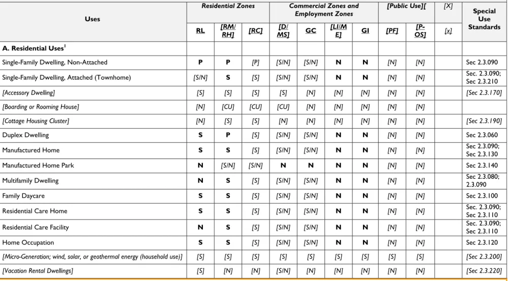
Table 2.2.030 – Uses Allowed by Zoning District
Uses
Residential Zones Commercial Zones and
Employment Zones [Public Use][ [X] Special
Use Standards RL [RMRH] / [RC] MS] [D/ GC [LIE] /M GI [PF] OS] [P- [x]
A. Residential Uses1
Single-Family Dwelling, Non-Attached P P [P] [S/N] [S/N] N N [N] [N] Sec 2.3.090
Single-Family Dwelling, Attached (Townhome) [S/N] S [S] [S/N] [S/N] N N [N] [N] Sec. 2.3.090; Sec 2.3.210
[Accessory Dwelling] [S] [S] [S] [S] [N] [N] [N] [N] [N] [Sec 2.3.170]
[Boarding or Rooming House] [N] [CU] [CU] [CU] [N] [N] [N] [N] [N]
[Cottage Housing Cluster] [N] [S] [S] [N] [N] [N] [N] [N] [N] [Sec 2.3.190]
Duplex Dwelling S P [S] [S/N] [S/N] N N [N] [N] Sec 2.3.060
Manufactured Home S S [S] [S/N] [S/N] N N [N] [N] Sec 2.3.090; Sec 2.3.130
Manufactured Home Park N [S/N] [S/N] N N N N [N] [N] Sec 2.3.140
Multifamily Dwelling N S [S] [S/N] [S/N] N N [N] [N] Sec 2.3.080; 2.3.090
Family Daycare S S [S] [S/N] [S/N] N N [N] [N] Sec 2.3.100
Residential Care Home S S [S] [S/N] [S/N] N N [N] [N] Sec. 2.3.090; Sec 2.3.110
Residential Care Facility N S [S] [S/N] [S/N] N N [N] [N] Sec. 2.3.090; Sec 2.3.110
Home Occupation S S [S] [S/N] [S/N] N N [N] [N] Sec 2.3.120
[Micro-Generation; wind, solar, or geothermal energy (household use)] [S] [S] [S] [S] [S] [S] [S] [S] [S] [Sec 2.3.200]
[Vacation Rental Dwellings] [S] [N] [N] [S/N] [N] [N] [N] [N] [N] [Sec 2.3.220]
User’s Guide: The above residential uses represent the range of “needed housing” that cities are generally required to zone land for under Statewide Planning Goal 10 (Housing). Care Homes or Facilities are subject to ORS 197.665 and 197.670, and the federal Fair Housing Amendments Act of 1988 (42 U.S.C. § 3615). The model code provides clear and objective standards for housing, per state law, and allows residential uses in commercial districts, per OAR 660-012-060.
2.2 – Zoning District Regulations | Allowed Uses
City of [Name] 2-10 Draft #__ - [Date]
Oregon Model Development Code
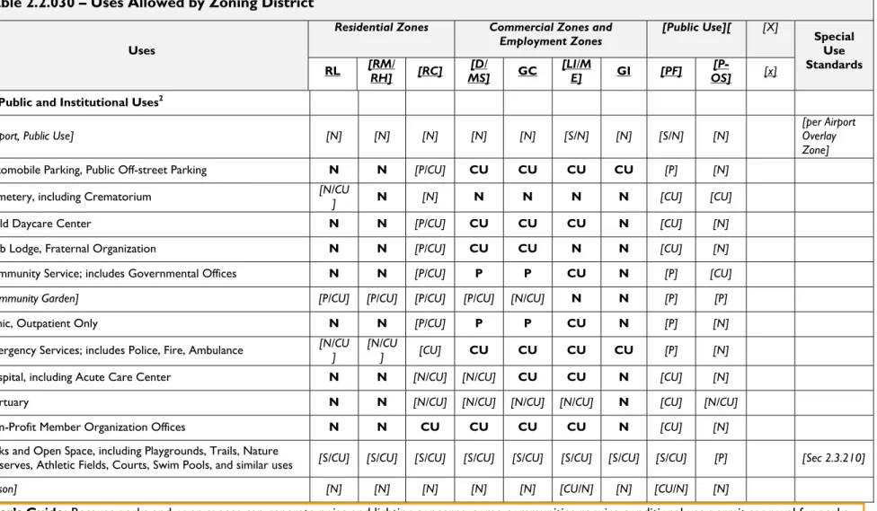
Table 2.2.030 – Uses Allowed by Zoning District
Uses
Residential Zones Commercial Zones and
Employment Zones [Public Use][ [X] Special
Use Standards RL [RMRH] / [RC] MS] [D/ GC [LIE] /M GI [PF] OS] [P- [x]
B. Public and Institutional Uses2
[Airport, Public Use] [N] [N] [N] [N] [N] [S/N] [N] [S/N] [N] [per Airport Overlay
Zone]
Automobile Parking, Public Off-street Parking N N [P/CU] CU CU CU CU [P] [N]
Cemetery, including Crematorium [N/CU] N [N] N N N N [CU] [CU]
Child Daycare Center N N [P/CU] CU CU CU N [CU] [N]
Club Lodge, Fraternal Organization N N [P/CU] CU CU N N [CU] [N]
Community Service; includes Governmental Offices N N [P/CU] P P CU N [P] [CU]
[Community Garden] [P/CU] [P/CU] [P/CU] [P/CU] [N/CU] N N [P] [P]
Clinic, Outpatient Only N N [P/CU] P P CU N [P] [N]
Emergency Services; includes Police, Fire, Ambulance [N/CU] [N/CU] [CU] CU CU CU CU [P] [N]
Hospital, including Acute Care Center N N [N/CU] [N/CU] CU CU N [CU] [N]
Mortuary N N [N/CU] [N/CU] [N/CU] [N/CU] N [CU] [N/CU]
Non-Profit Member Organization Offices N N CU CU CU CU N [CU] [N]
Parks and Open Space, including Playgrounds, Trails, Nature
Preserves, Athletic Fields, Courts, Swim Pools, and similar uses [S/CU] [S/CU] [S/CU] [S/CU] [S/CU] [S/CU] [S/CU] [S/CU] [P] [Sec 2.3.210]
[Prison] [N] [N] [N] [N] [N] [CU/N] [N] [CU/N] [N]
User’s Guide: Because parks and open spaces can generate noise and lighting concerns, some communities require conditional use permit approval for parks and some open space uses. Another alternative is to allow uses subject to special standards. For example, neighborhood parks (e.g., tot lots or informal play fields) and natural areas that are limited to daytime use typically do not raise compatibility concerns and therefore can be permitted with standards.
2.2 – Zoning District Regulations | Allowed Uses
City of [Name] 2-11 Draft #__ - [Date]
Development Code
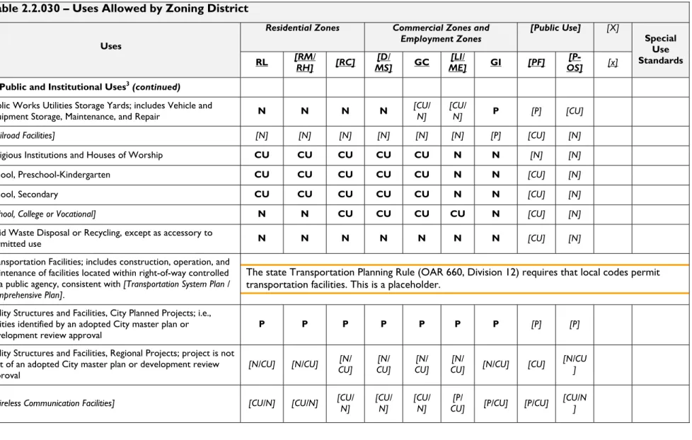
Table 2.2.030 – Uses Allowed by Zoning District
Uses
Residential Zones Commercial Zones and
Employment Zones [Public Use] [X] Special Use Standards RL [RMRH] / [RC] MS] [D/ GC ME] [LI/ GI [PF] OS] [P- [x]
B. Public and Institutional Uses3(continued)
Public Works Utilities Storage Yards; includes Vehicle and
Equipment Storage, Maintenance, and Repair N N N N [CU/ N] [CU/N] P [P] [CU]
[Railroad Facilities] [N] [N] [N] [N] [N] [N] [P] [CU] [N]
Religious Institutions and Houses of Worship CU CU CU CU CU N N [N] [N]
School, Preschool-Kindergarten CU CU CU CU CU N N [CU] [N]
School, Secondary CU CU CU CU CU N N [CU] [N]
[School, College or Vocational] N N CU CU CU CU N [CU] [N]
Solid Waste Disposal or Recycling, except as accessory to
permitted use N N N N N N N [CU] [N]
Transportation Facilities; includes construction, operation, and maintenance of facilities located within right-of-way controlled
by a public agency, consistent with [Transportation System Plan /
Comprehensive Plan].
The state Transportation Planning Rule (OAR 660, Division 12) requires that local codes permit transportation facilities. This is a placeholder.
Utility Structures and Facilities, City Planned Projects; i.e., utilities identified by an adopted City master plan or
development review approval P P P P P P P [P] [P]
Utility Structures and Facilities, Regional Projects; project is not part of an adopted City master plan or development review
approval [N/CU] [N/CU]
[N/
CU] CU] [N/ CU] [N/ CU] [N/ [N/CU] [CU] [N/CU]
[Wireless Communication Facilities] [CU/N] [CU/N] [CU/ N] [CU/ N] [CU/ N] CU] [P/ [P/CU] [P/CU] [CU/N]
2.2 – Zoning District Regulations | Allowed Uses
City of [Name] 2-12 Draft #__ - [Date]
Oregon Model Development Code
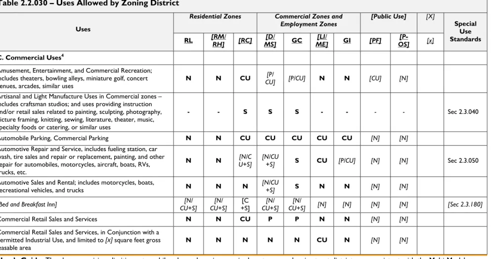
Table 2.2.030 – Uses Allowed by Zoning District
Uses
Residential Zones Commercial Zones and
Employment Zones [Public Use] [X] Special Use Standards RL [RMRH] / [RC] MS] [D/ GC ME] [LI/ GI [PF] OS] [P- [x]
C. Commercial Uses4
Amusement, Entertainment, and Commercial Recreation; includes theaters, bowling alleys, miniature golf, concert
venues, arcades, similar uses N N CU
[P/
CU] [P/CU] N N [CU] [N]
Artisanal and Light Manufacture Uses in Commercial zones – includes craftsman studios; and uses providing instruction and/or retail sales related to painting, sculpting, photography, picture framing, knitting, sewing, literature, theater, music, specialty foods or catering, or similar uses
- - S S S - - - - Sec 2.3.040
Automobile Parking, Commercial Parking N N CU CU CU CU CU [N] [N]
Automotive Repair and Service, includes fueling station, car wash, tire sales and repair or replacement, painting, and other repair for automobiles, motorcycles, aircraft, boats, RVs, trucks, etc.
N N U+S] [N/C [N/CU+S] S CU [P/CU] [N] [N] Sec 2.3.050
Automotive Sales and Rental; includes motorcycles, boats,
recreational vehicles, and trucks N N N [N/CU+S] S N N [N] [N]
[Bed and Breakfast Inn] CU+S][N/ CU+S][N/ +S] [C CU+S][N/ CU+S] [N/ [N] [N] [N] [N] [Sec 2.3.180]
Commercial Retail Sales and Services N N CU P P N N [N] [N]
Commercial Retail Sales and Services, in Conjunction with a
Permitted Industrial Use, and limited to [x] square feet gross
leasable area N N N N N CU N [N] [N]
User’s Guide: The above provisions limiting automobile sales and service uses in downtowns and main street districts are consistent with the Multi-Modal Mixed Use provisions under OAR 660-012-060. See also, the drive-through service and general industrial use regulations in other parts of this table. The provision for “artisanal uses” is intended to encourage cottage industries that combine light manufacturing and retail uses in commercial zones.
2.2 – Zoning District Regulations | Allowed Uses
City of [Name] 2-13 Draft #__ - [Date]
Development Code
Table 2.2.030 – Uses Allowed by Zoning District
Uses
Residential Zones Commercial Zones and
Employment Zones [Public Use] [X] Special Use Standards RL [RMRH] / [RC] MS] [D/ GC ME] [LI/ GI [PF] OS] [P- [x]
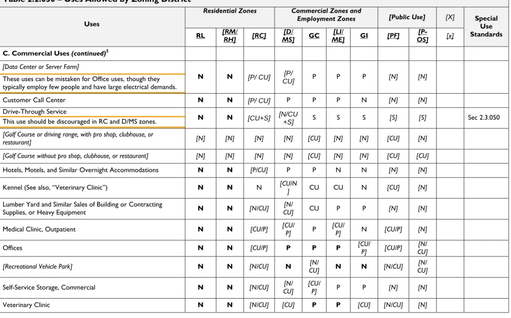
C. Commercial Uses (continued)5 [Data Center or Server Farm]
These uses can be mistaken for Office uses, though they typically employ few people and have large electrical demands.
N N [P/ CU] [P/
CU] P P P [N] [N]
Customer Call Center N N [P/ CU] P P P N [N] [N]
Drive-Through Service
This use should be discouraged in RC and D/MS zones. N N [CU+S] [N/CU+S] S S S [S] [S] Sec 2.3.050
[Golf Course or driving range, with pro shop, clubhouse, or
restaurant] [N] [N] [N] [N] [CU] [N] [N] [CU] [N]
[Golf Course without pro shop, clubhouse, or restaurant] [N] [N] [N] [N] [CU] [N] [N] [CU] [CU]
Hotels, Motels, and Similar Overnight Accommodations N N [P/CU] P P N N [N] [N]
Kennel (See also, “Veterinary Clinic”) N N N [CU/N] CU CU N [CU] [N]
Lumber Yard and Similar Sales of Building or Contracting
Supplies, or Heavy Equipment N N [N/CU] CU][N/ CU P P [N] [N]
Medical Clinic, Outpatient N N [CU/P] [CU/ P] P [CU/ P] N [CU/P] [N]
Offices N N [CU/P] P P P [CU/ P] [CU/P] CU] [N/
[Recreational Vehicle Park] N N [N/CU] N CU][N/ N N [N/CU] CU] [N/
Self-Service Storage, Commercial N N [N/CU] CU][N/ [CU/ P] P P [N] [N]
Veterinary Clinic N N [N/CU] [CU] P P [CU] [N/CU] [N]
2.2 – Zoning District Regulations | Allowed Uses
City of [Name] 2-14 Draft #__ - [Date]
Oregon Model Development Code
Table 2.2.030 – Uses Allowed by Zoning District
Uses
Residential Zones Commercial Zones and Employment
Zones [Public Use] Zones][Other Special Use
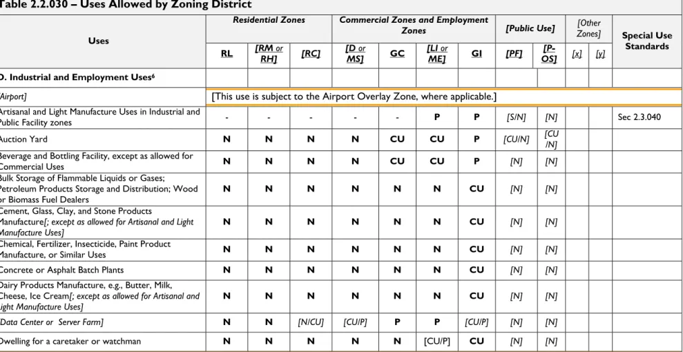
Standards RL [RM RH]or [RC] [D MS] or GC [LI ME] or GI [PF] OS] [P- [x] [y]
D. Industrial and Employment Uses6
[Airport] [This use is subject to the Airport Overlay Zone, where applicable.]
Artisanal and Light Manufacture Uses in Industrial and
Public Facility zones - - - - - P P [S/N] [N] Sec 2.3.040
Auction Yard N N N N CU CU P [CU/N] [CU/N]
Beverage and Bottling Facility, except as allowed for
Commercial Uses N N N N CU CU P [N] [N]
Bulk Storage of Flammable Liquids or Gases; Petroleum Products Storage and Distribution; Wood
or Biomass Fuel Dealers N N N N N N CU [N] [N]
Cement, Glass, Clay, and Stone Products
Manufacture[; except as allowed for Artisanal and Light
Manufacture Uses] N N N N N N CU [N] [N]
Chemical, Fertilizer, Insecticide, Paint Product
Manufacture, or Similar Uses N N N N N N CU [N] [N]
Concrete or Asphalt Batch Plants N N N N N N CU [N] [N]
Dairy Products Manufacture, e.g., Butter, Milk,
Cheese, Ice Cream[; except as allowed for Artisanal and
Light Manufacture Uses] N N N N N N CU [N] [N]
[Data Center or Server Farm] N N [N/CU] [CU/P] P P [CU/P] [N] [N]
Dwelling for a caretaker or watchman N N N N N [CU/P] CU [N] [N]
User’s Guide: Industrial and employment uses vary in scale and intensity from city to city. Therefore concerns about land use impacts are not the same in all communities. The above list of uses should be tailored to fit your community based on local planning priorities and economic factors. Zoning for airports and for uses within airport approaches must conform to the state Airport Planning Rule (OAR 660-013). See Oregon Aviation Department Land Use Compatibility Guidelines and Model Ordinance.
2.2 – Zoning District Regulations | Allowed Uses
City of [Name] 2-15 Draft #__ - [Date]
Development Code
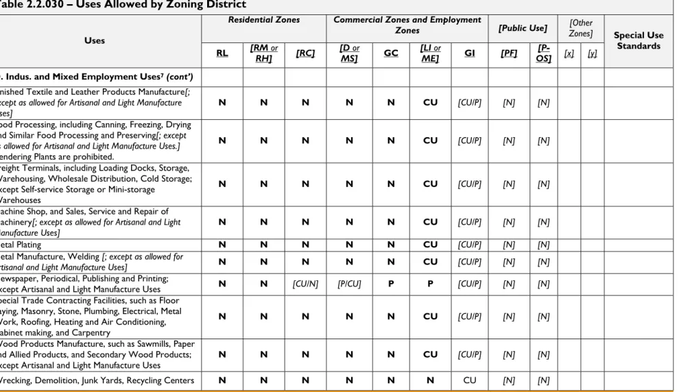
Table 2.2.030 – Uses Allowed by Zoning District
Uses
Residential Zones Commercial Zones and Employment
Zones [Public Use] Zones][Other Special Use
Standards RL [RM RH]or [RC] [D MS] or GC [LI ME] or GI [PF] OS] [P- [x] [y]
D. Indus. and Mixed Employment Uses7 (cont’)
Finished Textile and Leather Products Manufacture[;
except as allowed for Artisanal and Light Manufacture
Uses] N N N N N CU [CU/P] [N] [N]
Food Processing, including Canning, Freezing, Drying
and Similar Food Processing and Preserving[; except
as allowed for Artisanal and Light Manufacture Uses.] Rendering Plants are prohibited.
N N N N N CU [CU/P] [N] [N]
Freight Terminals, including Loading Docks, Storage, Warehousing, Wholesale Distribution, Cold Storage; except Self-service Storage or Mini-storage
Warehouses
N N N N N CU [CU/P] [N] [N]
Machine Shop, and Sales, Service and Repair of
Machinery[; except as allowed for Artisanal and Light
Manufacture Uses] N N N N N CU [CU/P] [N] [N]
Metal Plating N N N N N CU [CU/P] [N] [N]
Metal Manufacture, Welding [; except as allowed for
Artisanal and Light Manufacture Uses] N N N N N CU [CU/P] [N] [N]
Newspaper, Periodical, Publishing and Printing;
except Artisanal and Light Manufacture Uses N N [CU/N] [P/CU] P P [CU/P] [N] [N]
Special Trade Contracting Facilities, such as Floor Laying, Masonry, Stone, Plumbing, Electrical, Metal Work, Roofing, Heating and Air Conditioning, Cabinet making, and Carpentry
N N N N N CU [CU/P] [N] [N]
Wood Products Manufacture, such as Sawmills, Paper and Allied Products, and Secondary Wood Products;
except Artisanal and Light Manufacture Uses N N N N N CU [CU/P] [N] [N]
Wrecking, Demolition, Junk Yards, Recycling Centers N N N N N N CU [N] [N]
User’s Guide: Industrial and employment uses vary in scale and intensity from city to city. Therefore concerns about land use impacts are not the same in all communities. The above list of uses should be tailored to fit your community based on local planning priorities and economic factors.
2.2 – Zoning District Regulations | Lot and Development Standards
City of [Name] 2-16 Draft #__ - [Date]
Oregon Model Development Code
2.2.040
Lot and Development Standards
A. Development Standards. Section 2.2.040 provides the general lot and development standards for each of the City’s base zoning districts. The standards of Section 2.2.040 are organized into two tables: Table 2.2.040.D applies to Residential [and Residential-Commercial] zones, and Table 2.2.040.E applies to non-residential zones.
B. Design Standards. City standards for Access, Circulation, Site and Building Design, Parking, Landscaping, Fences and Screening, and Public Improvements, among others, are located in Article 3. Notwithstanding the provisions of Table 2.2.040 and Article 3, different standards may apply in specific locations, such as at street intersections, [within overlay zones,] adjacent to natural features, and other areas as may be regulated by this Code or subject to state or federal requirements. [For requirements applicable to the City’s overlay zones, please refer to Chapter 2.4.]
C. Disclaimer. Property owners are responsible for verifying whether a proposed development meets the applicable standards of this Code. [Submittal of a Zoning Checklist for review and approval by the City (Planning Official) (is / may be) required in order to determine whether use is allowed on a given site, and whether further land use review is required.]
User’s Guide: The minimum lot sizes and other dimensions contained in 2.2.040 are based on contemporary zoning standards and development practices in small- and medium-sized Oregon communities. The standards should be reviewed and adjusted to fit the context of the community. The standards are also more flexible than conventional zoning, so that minor adjustments in lot size, for example through the “lot size averaging,” “sloping site,” and “lot coverage bonus” provisions, can be made without requiring variances or planned unit approval. This section is also designed to promote efficient land use and pedestrian-oriented design, for example, through the required “build-to line” in multifamily and residential-commercial projects. Table 2.2.040 does not recommend specific residential densities; cities should base minimum and maximum density standards on the locally adopted comprehensive plan, including an assessment of housing needs and urban growth management policies.
2.2 –Zoning District Regulations | Lot and Development Standards
City of [Name] 2-17 Draft #__ - [Date]
Oregon Model Development Code
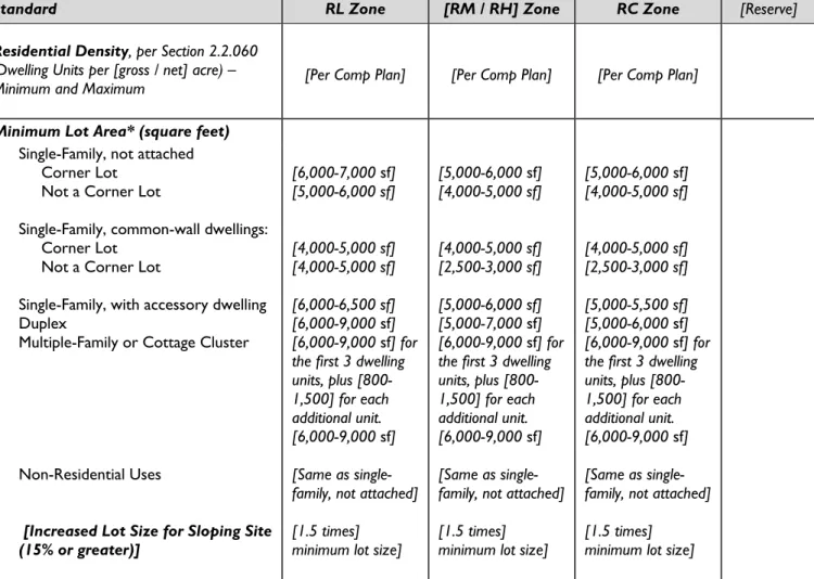
D. Lot and Development Standards for Residential Districts.The development standards in Table 2.2.040.D apply to all [new] development [as of (effective date)] in Residential zones.
Table 2.2.040.D – Lot and Development Standards for Residential zones8
(Except as provided by 2.2.040.F through 2.2.080, as modified under Chapter 4.7 Adjustments and Variances, or as approved under Chapter 4.8 Master Planned Developments.)
Standard RL Zone [RM / RH] Zone RC Zone [Reserve]
Residential Density, per Section 2.2.060 (Dwelling Units per [gross / net] acre) –
Minimum and Maximum [Per Comp Plan] [Per Comp Plan] [Per Comp Plan]
Minimum Lot Area* (square feet) Single-Family, not attached Corner Lot
Not a Corner Lot
Single-Family, common-wall dwellings: Corner Lot
Not a Corner Lot
Single-Family, with accessory dwelling Duplex
Multiple-Family or Cottage Cluster
Non-Residential Uses
[Increased Lot Size for Sloping Site (15% or greater)] [6,000-7,000 sf] [5,000-6,000 sf] [4,000-5,000 sf] [4,000-5,000 sf] [6,000-6,500 sf] [6,000-9,000 sf] [6,000-9,000 sf] for the first 3 dwelling units, plus [800-1,500] for each additional unit. [6,000-9,000 sf] [Same as single-family, not attached] [1.5 times]
minimum lot size]
[5,000-6,000 sf] [4,000-5,000 sf] [4,000-5,000 sf] [2,500-3,000 sf] [5,000-6,000 sf] [5,000-7,000 sf] [6,000-9,000 sf] for the first 3 dwelling units, plus [800-1,500] for each additional unit. [6,000-9,000 sf] [Same as single-family, not attached] [1.5 times]
minimum lot size]
[5,000-6,000 sf] [4,000-5,000 sf] [4,000-5,000 sf] [2,500-3,000 sf] [5,000-5,500 sf] [5,000-6,000 sf] [6,000-9,000 sf] for the first 3 dwelling units, plus [800-1,500] for each additional unit. [6,000-9,000 sf] [Same as single-family, not attached] [1.5 times]
minimum lot size]
User’s Guide: Minimum lot size should be based on a city’s planned residential densities, per the land use designations and housing needs in the comprehensive plan. An alternative to increasing lot size standards for sloping sites is to allow clustering of smaller lots in exchange for open space conservation on the most sensitive hillsides. See also,
recommendations for “Lot Size Averaging” below.
[*Lot size may be reduced in new subdivisions through Lot Size Averaging, per Section 4.3.050, or through approval of a Master Planned Development under Chapter 4.8, provided the density standards of this section are met.] Minimum lot sizes do not apply to open space tracts and similar properties where development is restricted.
2.2 –Zoning District Regulations | Lot and Development Standards
City of [Name] 2-18 Draft #__ - [Date]
Oregon Model Development Code
Table 2.2.040.D – Lot and Development Standards for Residential zones8
(Except as provided by 2.2.040.F through 2.2.080, as modified under Chapter 4.7 Adjustments and Variances, or as approved under Chapter 4.8 Master Planned Developments.)
Standard RL Zone [RM / RH] Zone RC Zone [Reserve]
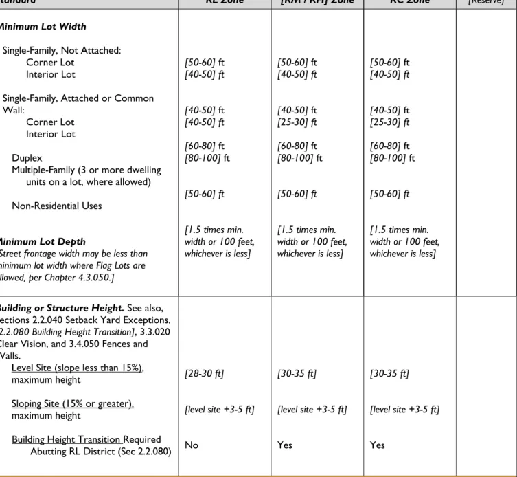
Minimum Lot Width Single-Family, Not Attached:
Corner Lot Interior Lot
Single-Family, Attached or Common Wall:
Corner Lot Interior Lot Duplex
Multiple-Family (3 or more dwelling units on a lot, where allowed) Non-Residential Uses
Minimum Lot Depth
[Street frontage width may be less than minimum lot width where Flag Lots are allowed, per Chapter 4.3.050.]
[50-60] ft [40-50] ft [40-50] ft [40-50] ft [60-80] ft [80-100] ft [50-60]ft [1.5 times min. width or 100 feet, whichever is less] [50-60] ft [40-50] ft [40-50] ft [25-30] ft [60-80] ft [80-100] ft [50-60]ft [1.5 times min. width or 100 feet, whichever is less] [50-60] ft [40-50] ft [40-50] ft [25-30] ft [60-80] ft [80-100] ft [50-60]ft [1.5 times min. width or 100 feet, whichever is less]
Building or Structure Height. See also, Sections 2.2.040 Setback Yard Exceptions, [2.2.080 Building Height Transition], 3.3.020 Clear Vision, and 3.4.050 Fences and Walls.
Level Site (slope less than 15%), maximum height
Sloping Site (15% or greater), maximum height
Building Height Transition Required Abutting RL District (Sec 2.2.080)
[28-30 ft] [level site +3-5 ft] No [30-35 ft] [level site +3-5 ft] Yes [30-35 ft] [level site +3-5 ft] Yes
User’s Guide: The building height standards for sloping lots are intended to provide regulatory relief for daylight basements. Adjustment for a sloping site may not be necessary if the city measures building height from “grade plane,” as defined by International Building Code. Grade plane provides for height adjustment on sloping lots by using an average finished grade as the basis for measuring height.
2.2 –Zoning District Regulations | Lot and Development Standards
City of [Name] 2-19 Draft #__ - [Date]
Oregon Model Development Code
Table 2.2.040.D – Lot and Development Standards for Residential zones8
(Except as provided by 2.2.040.F through 2.2.080, as modified under Chapter 4.7 Adjustments and Variances, or as approved under Chapter 4.8 Master Planned Developments.)
Standard RL Zone [RM / RH] Zone RC Zone [Reserve]
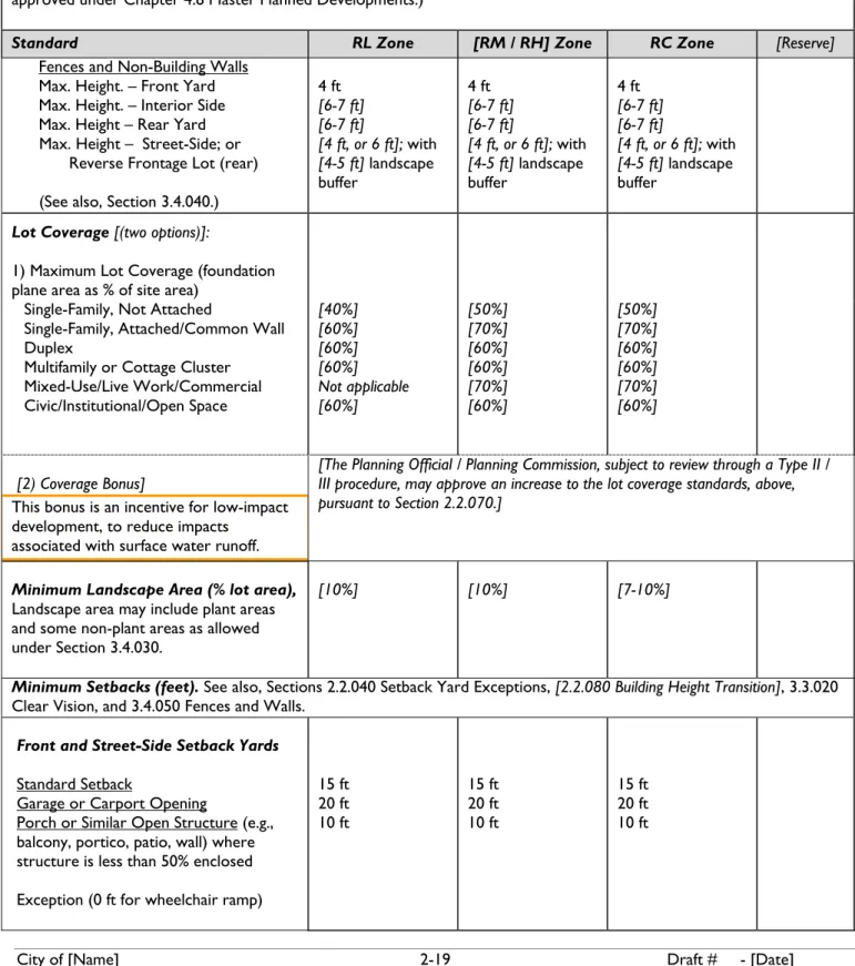
Fences and Non-Building Walls Max. Height. – Front Yard Max. Height. – Interior Side Max. Height – Rear Yard Max. Height – Street-Side; or
Reverse Frontage Lot (rear) (See also, Section 3.4.040.)
4 ft [6-7 ft] [6-7 ft] [4 ft, or 6 ft]; with [4-5 ft] landscape buffer 4 ft [6-7 ft] [6-7 ft] [4 ft, or 6 ft]; with [4-5 ft] landscape buffer 4 ft [6-7 ft] [6-7 ft] [4 ft, or 6 ft]; with [4-5 ft] landscape buffer
Lot Coverage [(two options)]:
1) Maximum Lot Coverage (foundation plane area as % of site area)
Single-Family, Not Attached
Single-Family, Attached/Common Wall Duplex
Multifamily or Cottage Cluster Mixed-Use/Live Work/Commercial Civic/Institutional/Open Space [40%] [60%] [60%] [60%] Not applicable [60%] [50%] [70%] [60%] [60%] [70%] [60%] [50%] [70%] [60%] [60%] [70%] [60%] [2) Coverage Bonus]
This bonus is an incentive for low-impact development, to reduce impacts
associated with surface water runoff.
[The Planning Official / Planning Commission, subject to review through a Type II / III procedure, may approve an increase to the lot coverage standards, above, pursuant to Section 2.2.070.]
Minimum Landscape Area (% lot area), Landscape area may include plant areas and some non-plant areas as allowed under Section 3.4.030.
[10%] [10%] [7-10%]
Minimum Setbacks (feet). See also, Sections 2.2.040 Setback Yard Exceptions, [2.2.080 Building Height Transition], 3.3.020 Clear Vision, and 3.4.050 Fences and Walls.
Front and Street-Side Setback Yards Standard Setback
Garage or Carport Opening
Porch or Similar Open Structure (e.g., balcony, portico, patio, wall) where structure is less than 50% enclosed Exception (0 ft for wheelchair ramp)
15 ft 20 ft 10 ft 15 ft 20 ft 10 ft 15 ft 20 ft 10 ft
2.2 –Zoning District Regulations | Lot and Development Standards
City of [Name] 2-20 Draft #__ - [Date]
Oregon Model Development Code
Table 2.2.040.D – Lot and Development Standards for Residential zones8
(Except as provided by 2.2.040.F through 2.2.080, as modified under Chapter 4.7 Adjustments and Variances, or as approved under Chapter 4.8 Master Planned Developments.)
Standard RL Zone [RM / RH] Zone RC Zone [Reserve]
Interior Side Setback Yards Structure >24’ height (total of 2 interior sides, with no setback yard less than 3 ft)
Structure 12’-24’ height (total of 2 interior sides, with no setback yard less than 3 ft)
Structure <12’ height (total of 2 interior sides, with no setback yard less than 3 ft)
Garage or Carport Opening, except alley Exceptions:
Alley
Porch or Similar Open Structure (e.g., balcony, wheelchair ramp, portico, patio, wall) where structure is less than 50% enclosed
Common Walls or Zero Lot Line Developments [10-15] ft 10 ft [6-10] ft 20 ft 5 ft 5 ft 0 ft one side; [5-10] ft other side 10 ft 10 ft 10 ft 20 ft 5 ft 5 ft 0 ft one side; [5-10] ft other side 10 ft 10 ft 10 ft 20 ft 5 ft 5 ft 0 ft one side; [5-10] ft other side
Note: Always avoid utility easements when building near property lines.
User’s Guide: The city may require fire suppression sprinkler systems for some structures where, due to the structure’s height, sprinkler systems are necessary.
2.2 –Zoning District Regulations | Lot and Development Standards
City of [Name] 2-21 Draft #__ - [Date]
Oregon Model Development Code
Table 2.2.040.D – Lot and Development Standards for Residential zones8
(Except as provided by 2.2.040.F through 2.2.080, as modified under Chapter 4.7 Adjustments and Variances, or as approved under Chapter 4.8 Master Planned Developments.)
Standard RL Zone [RM / RH] Zone RC Zone [Reserve]
Rear Setback Yard Structure >24’ height Structure 12’-24’ height Structure <12’ height
Garage or Carport Opening, except alley Exceptions:
Alley
Porch or Similar Open Structure (e.g., balcony, portico, patio wall) where structure is <50% enclosed Common Walls or Zero Lot Line
[10-15] ft 10 ft [5-10] ft 20 ft 5 ft 5 ft 0 ft 10 ft 10 ft 10 ft 20 ft 5 ft 5 ft 0 ft 10 ft 10 ft 10 ft 20 ft 5 ft 5 ft 0 ft
Build-To Line (feet):
Applies to New Buildings Only, except does not apply to detached single-family dwellings:
1) At least one primary building entrance shall be built no farther from the street right-of-way than the build-to line; except that where a greater setback is required for a Planned Street Improvement, the build-to line increases
proportionately.
2) The City may also approve exceptions to the build-to line through Site Design Review where pedestrian amenities are provided between a primary building entrance and the street right-of-way. (See also, Section 3.2.060 Civic Space and Pedestrian Amenities.)
Not Applicable [15-20 ft; may be increased when pedestrian amenities are provided between a primary building entrance and street] [15-20 ft; may be increased when pedestrian amenities are provided between a primary building entrance and street] __
Special Setback for Planned Street Improvements: New structures or structure additions on lots abutting an existing public street that does not meet the minimum standards of Section 3.6.020 for right-of-way width shall provide setbacks sufficient to allow for the future widening of the right-of-way, plus the minimum required yard setback. Building permits shall not be issued for new structures or additions that do not meet this standard.
2.2 –Zoning District Regulations | Lot and Development Standards
City of [Name] 2-22 Draft #__ - [Date]
Oregon Model Development Code
E. Lot and Development Standards for Non-Residential Districts.The development standards in Table 2.2.040.E apply to all [new] development [as of (effective date)] in the City’s Non-Residential zones, as follows.
Table 2.2.040.E – Lot and Development Standards for Non-Residential zones9
(Except as provided by 2.2.040.F through 2.2.080, as modified under Chapter 4.7 Adjustments and Variances, or as approved under Chapter 4.8 Master Planned Developments.)
Standard [D / MS] Zone GC and [LI / ME] Zones GI Zone PF and OS Zones
Minimum Lot Area* (square feet) *Development must conform to lot width, depth, yard setback, and coverage standards.
None [None, or # acres, per Economic
Opportunities Analysis] None
Minimum Lot Width and Depth None [None, or # acres, per Economic
Opportunities Analysis] None Building and Structure Height*
Standard (slope less than 15%), maximum height
[Sloping Site (15% or greater), maximum height]
[Height Bonus for Residential Use in Upper Building Story]
[Building Height Transition required adjacent to RL District, per Section 2.2.080.]
*[Height Increase
The City may increase the standard height, above, for specific projects with approval of a Conditional Use Permit (CUP), per Chapter 4.4.]
[35-60 ft] [standard +5 ft] [10-15 ft] [Yes/No] [Yes/No] [35-50 ft] [standard +5 ft] [10 ft in GC and ME / None] [Yes/No] [Yes/No] [35-50 ft] [standard +5 ft] None [Yes/No] [Yes/No] [35-50 ft] [standard +5 ft] None [Yes/No] [Yes/No]
User’s Guide: The city may require fire suppression sprinkler systems for some structures where, due to the structure’s height, sprinkler systems are necessary.
2.2 –Zoning District Regulations | Lot and Development Standards
City of [Name] 2-23 Draft #__ - [Date]
Oregon Model Development Code
Table 2.2.040.E – Lot and Development Standards for Non-Residential zones9
(Except as provided by 2.2.040.F through 2.2.080, as modified under Chapter 4.7 Adjustments and Variances, or as approved under Chapter 4.8 Master Planned Developments.)
Standard [D / MS] Zone GC and [LI / ME] Zones GI Zone PF and OS Zones
Fences and Non-Building Walls Maximum Height – Front Yard Maximum Height – Interior Side Maximum Height – Rear Yard Maximum Height – Street-Side or
Reverse Frontage Lot (rear) (See also, Section 3.4.040.)
4 ft 6 ft 6 ft
4 ft, or 6 ft with 5 ft landscape buffer
4 ft, except City-required screens 6 ft,except City-required screens 6 ft,except City-required screens 4 ft, or [6 ft] with
5 ft landscape buffer
Lot Coverage [(two options)]: 1. Maximum Lot Coverage (foundation plane area as % of site
area) 90% 80%
[2. Coverage Bonus] [The Planning Official / Planning Commission, subject to review through a Type II / III procedure, may approve an increase to the lot coverage standards, above, pursuant to Section 2.2.070.]
Minimum Landscape Area (% site area), includes required parking lot landscaping and any required screening. This standard does not apply to individual, detached single-family dwellings.
[Landscape area may include street trees and civic space improvements in some zones, per Sections 3.2.050 and 3.4.030.]
2.2 –Zoning District Regulations | Lot and Development Standards
City of [Name] 2-24 Draft #__ - [Date]
Oregon Model Development Code
Table 2.2.040.E – Lot and Development Standards for Non-Residential zones10
(Except as provided by 2.2.040-2.2.080, or as modified under Chapter 4.5 Master Planned Developments and Chapter 4.7 Adjustments and Variances)
Standard [C-D/M] GC [Reserve]
Minimum Setback Yards (feet): (See also, Section 2.2.080, RL Height Step-Down.)
Front, Street-Side, Interior Side, and Rear property lines, except garage or carport, or as required by other code provisions
Garage or Carport Entry, setback from street Alley Adjacent to RL District 0 ft 20 ft 3 ft
10 ft, and per Section 2.2.170
0 ft
20 ft
3 ft
10 ft, and per Section 2.2.170
__
__
__ __
Build-To Line (feet):
New Buildings Only: At least one primary building entrance shall be built no farther from the street right-of-way than the build-to line; except where a greater setback is required for a Planned Street Improvement, then the build-to line increases proportionately. The build-to line may also be increased through Site Design Review when pedestrian amenities are provided between a primary building entrance and the street right-of-way. (See also, Section 2.3.190.)
[0 ft; may be increased when pedestrian amenities are provided between a primary building entrance and street]
[60 ft; may be increased when a shopping street connects the primary building entrance(s) to the street, per Section 2.3.170]
__
Special Setback for Planned Street Improvements: New structures or structure additions on lots abutting an existing public street that does not meet the minimum standards of Section 3.6.020 for right-of-way width shall provide setbacks sufficient to allow for the future widening of the right-of-way, plus the minimum required yard setback. Building permits shall not be issued for new structures or additions that do not meet this standard.
Note: Always check for utility easements prior to construction.
2.2 – Zoning District Regulations: Setback Yards Exceptions
City of [Name] 2-25 Draft #__ - [Date]
Oregon Model Development Code
2.2.050
Setback Yards Exceptions
User’s Guide: The following supplements the dimensional standards in the above tables. The flag lot standards are optional because not all cities allow flag lots. Flag lots should be discouraged where local street connections are to be made. See also, Chapter 4.3 Land Divisions and Property Line Adjustments.
A. Encroachments
1. Except as otherwise restricted by applicable building codes, building elements such as eaves, chimneys, bay windows, overhangs, heating, cooling and ventilation systems, and similar incidental structures, may extend into the required setback yards by no more than [18-36] inches, provided that a setback of not less than 36 inches is maintained, all applicable building codes are met, and the clear vision standards in Section 3.3.030 are met.
2. Porches, decks, patios, and similar features not exceeding [30] inches in height may encroach into setbacks, provided a minimum setback of not less than 36 inches is maintained and all applicable building codes are met.
3. Fences may be placed within setback yards, subject to the standards of Section 2.2.040 and 3.4.040. B. Reverse Frontage Lots
Buildings on reverse-frontage lots (through lots) are required to meet the build-to line standard on only one street. Reverse frontage lots are subject to the fence height and setback requirements of Section 2.2.040 and the design standards (e.g., materials and landscape buffer requirements) of Section 3.4.040.
[C. Flag Lots
The (City decision-making body) shall designate the front yard of a flag lot to ensure compatibility with adjacent land uses, based on existing development patterns and location of adjacent driveways, utilities, and natural features, as either:
1. front yard parallel to the street providing automobile access; or
2. front yard parallel to the flagpole from which driveway access is received.
The City shall review proposals for flag lots pursuant to the standards in Section 4.3.050 and may impose reasonable conditions to ensure development is compatible with adjacent uses.]
2.2 –Zoning District Regulations | Lot Coverage
City of [Name] 2-26 Draft #__ - [Date]
Oregon Model Development Code
2.2.060
Residential Density Standards
To ensure efficient use of buildable lands and to provide for a range of needed housing in conformance with the Comprehensive Plan, all new [developments / subdivisions] in the Residential Districts shall conform to the minimum and maximum densities prescribed in Table 2.2.040, except as provided below in subsections 1-3:
User’s Guide: The following section is used in conjunction with Table 2.2.040. Your city should include minimum and maximum density standards in the table based on your comprehensive plan. Minimum density standards should apply to RM zones, at a minimum, and preferably in all residential and residential-commercial zones. Each city will need to determine how it calculates density. The following example is based on “gross density.”
If the gross (total) site area is five acres, and the minimum allowable density is six dwelling units per acre, then the maximum is 30 units. The equivalent average lot size for single-family dwellings is determined by subtracting street right-of-way, water quality facilities and other non-buildable areas from the five-acre site, then dividing the remaining (net) area by the number of units. Assuming 25 percent of the total site area for streets, open space, and other non-buildable areas, “average lot size” is calculated as follows: (217,800 square feet x 0.75) / 30 units = 5,445 square feet. If the minimum density were four dwelling units per acre, the same five-acre site would yield a minimum of 20 units with an average lot size of 8,168 square feet.
This is only an example. The minimum density standard also applies to attached housing, including multiple family
developments. Actual lot sizes will vary based on the proposed building type and the lot area standards in Section 2.2.030. The number of planned dwellings also varies depending on whether the comprehensive plan is based on net or gross density. Where a plan specifies four units per gross acre, the equivalent net density might be greater than five units per net acre.
A. Residential care homes and facilities, senior housing, including assisted living, accessory dwellings, and subdivisions where the average slope exceeds [15 percent] are exempt from the minimum density standard. B. The density standards may be averaged over more than one development phase (i.e., as in a master planned
development). Duplex lots used to comply with the density standard shall be so designated on the final subdivision plat.
C. Partitions and construction of single-family homes on lots exceeding [20,000-40,000 square feet] shall be located and constructed so that future division of such lots can occur and planned public facilities can be extended based on the minimum lot size and other applicable City standards.
D. Minimum and maximum housing densities are calculated by multiplying the total parcel or lot area by the applicable density standard.
2.2 –Zoning District Regulations | Residential Density Standards
City of [Name] 2-27 Draft #__ - [Date]
Oregon Model Development Code
2.2.070 Lot
Coverage
User’s Guide: The following supplements the lot coverage standards in Table 2.2.040. Subsection B is necessary if your city allows the lot coverage bonus in Table 2.2.040.
A. Lot Coverage Calculation. The maximum allowable lot coverage, as provided in Table 2.2.040.D, is calculated as the percentage of a lot or parcel covered by buildings and structures (as defined by the foundation plan area) at 36 inches or greater above the finished grade. It does not include paved surface-level developments such as driveways, parking pads, and patios that do not meet the minimum elevation of 36 inches above grade.
[B. Lot Coverage Bonus. The Planning Official / Planning Commission, subject to review through a Type II / III procedure, may approve increases to the lot coverage standards in Table 2.2.040.D, as follows:
1. Lot coverage may increase by up to one-half square foot for every one square foot of proposed automobile parking area to be contained in a parking structure, either above or below leasable ground floor space (e.g., residential, commercial, or civic use), not to exceed a 20 percent increase in allowable coverage.
2. Lot coverage may increase by up to one-half a square foot for every one square foot of proposed parking area paving that uses a City-approved porous or permeable paving material (i.e., allowing stormwater infiltration). 3. Lot coverage may increase by up to one-half a square foot for every one square foot of City-approved water
quality treatment area (e.g., vegetative swale or bio-filtration) to be provided on the subject site.
4. In approving increases in lot coverage under subsections 1-3 of this section, the City may require additional landscape buffering or screening, above that which is required by other provisions of this code, and may impose reasonable conditions of approval to ensure the ongoing maintenance of parking areas and surface water management facilities.
5. Notwithstanding the lot coverage increases authorized by this section, all other development standards of this chapter, and other applicable provisions of this Code, must be met.]