Neale H Stokes. A Study in Digital Geospatial History. A Master’s Paper for the M.S. in L.S. degree. May, Year. 40 pages. Advisor: Christopher Lee
This study addresses the growing field of “Digital Humanities,” specifically a subset of this field which makes use of digital geospatial technologies to represent historical events and places. The study explores literature surrounding the Digital Humanities in general, the involvement and collaboration of historians and archives in the Digital Humanities, and new possibilities afforded by the use of digital tools for engaging with the historical. Literature surrounding the use of Geographic Information Systems for history-focused digital projects is also reviewed. Three digital history projects with geospatial
components are then examined as case studies: Digital Harlem, Going to the Show, and PhilaPlace. By examining similarities and differences between these projects, this study seeks to draw general inferences about current practices within this new approach to representing historical knowledge.
Headings:
Digital libraries. Digital Humanities. Archives--Digitization.
by Neale Stokes
A Master’s paper submitted to the faculty of the School of Information and Library Science of the University of North Carolina at Chapel Hill
in partial fulfillment of the requirements for the degree of Master of Science in
Library Science.
Chapel Hill, North Carolina May 2011
Approved by
INTRODUCTION
In recent years the term “Digital Humanities” has become increasingly pervasive in the discourse of several academic and professional spheres. Rieger notes that in recent years “a burgeoning number of humanists are engaged in practices that fall under the rubric of Digital Humanities.” Since the establishment of the Office of Digital Humanities in 2007, the National Endowment for the Humanities has awarded more than 200 grants to support Digital Humanities projects.
In 2010, Google declared their “commitment to the Digital Humanities,”
announcing 12 unlimited grants to research projects at 15 universities in the United States and Europe. These projects were selected “because the resulting techniques, tools and data will be broadly useful: they'll help entire communities of scholars, not just the applicants” (Orwant). But despite this explosion of interest and activity surrounding the Digital Humanities, the term remains ambiguous and refers to a wide range of activities.
This study focuses on one trend within the Digital Humanities: collaborative digital history projects which make use of Geographic Information Systems (GIS) to spatially represent and provide access to historical information. These projects are increasingly numerous and feature collaboration between a wide range of institutions and
and new possibilities afforded by the use of digital tools for engaging with the historical. Literature surrounding the use of Geographic Information Systems for history-focused digital projects is also reviewed. Three digital history projects with geospatial
components are then examined as case studies: Digital Harlem, Going to the Show, and PhilaPlace. All three of these projects connect historical materials and data with
geospatial coordinates. They then use dynamic, digital maps to locate materials in visual representations of physical space. By examining similarities and differences between these projects, this study seeks to draw general inferences about current practices within this new approach to representing historical knowledge. The study concludes with a discussion of critical perspectives on these practices.
THE DIGITAL HUMANITIES
Digital Humanities is an expanding field, with both an increasing number of participants and a growing level of attention and funding from various institutions. However, “Digital Humanities” remains a multivalent and sometimes contentious term. Despite large
amounts of attention, new streams of funding, and a variety of scholarly and popular media focused on the term, Svensson contends that the “[t]erritory of the Digital
Humanities is currently under negotiation.” In a recent case study at Cornell University's Society for the Humanities, Rieger concludes that “Digital Humanities” constitutes something of a catchphrase among scholars engaged in both “traditional” and “digital” humanities work—it is generally regarded as a “piece of jargon.” Generally, however, Rieger concludes that Digital Humanities
to this phrase are full of tensions and varying opinions about the role of ICTs [information and communication technologies] in supporting, extending, or transforming humanities scholarship.
The term is applied to disparate activities, including “digital libraries, visualization, text mining, geographic information systems (GIS), multimedia, social networking, teaching with technology, open access, and digital culture”(Rieger). Svensson argues that it is not even clear that Digital Humanities could be considered a field and that it is even less clear that it constitutes a discipline, adding that this confusion and complexity “comes partly from its disciplinary and institutional diversity, and its multiple modes of engagement with information technology.”
Although the term ‘Digital Humanities' is nebulous, it is possible to identify some characteristics of the activities with which it is often identified. Svensson writes that it “would seem tenable to state that, minimally, Digital Humanities is manifested by a single scholar, teacher, artist, programmer, engineer, or student doing some kind of work — thinking, reflecting, writing, creating — at the intersection of the humanities and information technology — or by ‘products' resulting from such activities.” Another attempt at definition can be found in a post on the NEH Office of Digital Humanities (ODH) web site. According to the ODH site, Digital Humanities is applied as
many others. (Bobley 1)
While broad, these attempts at defining Digital Humanities are helpful—if only because they hint at the myriad activities that are all considered part of this rapidly expanding area of inquiry. While some scholars have reservations about the term, it proves to be both malleable and inclusive. And while it is possible to dismiss Digital Humanities as an empty buzzword, the term's multivalence may speak to the way in which, as Rieger writes, “research and teaching practices occur in a heterogeneous ecology of analog and digital settings, tools, and content” (Rieger).
of conversation and dialogue” (119). The blogging humanist represents a re-imagining of the spaces for humanities communication, while remaining conservative in its conception of what constitutes research and scholarship.
Moving beyond both these conceptions, McPherson identifies a third type of digital humanist, which she terms the “multimodal scholar.” The multimodal scholar, she
explains, shares many of the approaches and goals of both the computing and blogging humanists. However, multimodal scholarship moves beyond entrenched notions of what constitutes argument or even literacy. This new type of scholar
explores new forms of literacy that include authoring and analyzing visual, aural, dynamic, and interactive media. She also takes her cues from popular culture, imagining what it would be like to immerse yourself in a scholarly argument as you might immerse yourself in a movie or a video game. She investigates what happens when scholarship looks and feels differently, requiring new modes of engagement from the reader/user. She takes seriously such questions as ‘How do you 'experience' or 'feel' an argument in a more immersive and sensory-rich space?' ‘Can scholarship show as well as tell?' ‘Will representing data differently change the ways we understand, collect, or interpret it?' ‘What happens to
argument in a nonlinear environment?' (McPherson 120-21)
McPherson emphasizes that the conception of the “multimodal” humanities scholarship she envisions is not the same as simply publishing scholarship on the Internet—it embodies a novel conception of scholarship itself:
scholars come to realize that they understand their arguments and their objects of study differently, even better, when they approach them through multiple
modalities and emergent and interconnected forms of literacy. The ability to deploy new experiential, emotional, and even tactile aspects of argument and expression can open up fresh avenues of inquiry and research. (McPherson 121) McPherson offers some ideas of what these “digital forms” might be and just how they might work to “reorient the scholarly imagination.” For instance, the non-linear structure of a database is contrasted with the inherently linear arrangement of traditional scholarly writing or argument (121). Beyond possibilities for non-linear organization, other “modes” include various rich and/or interactive media experiences, such as immersive visualizations, simulations, and even games (122). One important element of these new “genres” is that they alter traditional relationships between producers and consumers of scholarly work—allowing for participation by those who may have once been mere passive readers of scholarship. They also stand to alter the relationship between the humanities and technology itself by reconfiguring “understandings of technology's role in the humanities (and vice versa), and, often, to broader publics in and outside of the academy” (122) In this way, multimodal humanities can be optimistically viewed as part of a broader insemination of humanities knowledge and approaches into the use and development of technology. This notion calls into question the underlying structures and assumptions of the digital tools—including both tools already in use, or to be adopted in the future. This is a point which will be addressed in more detail later in this study.
DIGITAL ARCHIVES, DIGITAL HISTORY
scholars and that of librarians/archivists (Bobley 2). This conflation of roles manifests in several ways, and is occurring for several reasons. The type of work done by scholars, especially those engaged in the Digital Humanities, is beginning to resemble work once exclusively in the domain of cultural repositories. This is also true of the reverse:
increasingly, librarians and archivists are taking on tasks previously ceded to scholars. As mentioned above, some of the earliest work in the “computing humanities” often took the form of large, infrastructural projects—the building of digital archives, databases, and tools to provide access to materials—projects that resembled the work of libraries more than scholars. These projects often focused acutely on the solving of technological problems rather than scholarly investigation and argument (McPherson 119). The NEH Office of Digital Humanities states that a large component of Digital Humanities work is connected to “collections of cultural heritage materials” (Bobley 1). While many Digital Humanities projects revolve around the creation of large-scale digital resources,
VandeCreek reminds us that these “these resources largely stem from an idea originally developed by librarians, the idea of ‘access.'” Rydberg-Cox also emphasizes the overlap and confusion between the more recent digital projects of scholars and digital library projects. Many digital library projects, while ultimately subsumed by libraries or similar institutions, were born of research by scholars (11).
increasingly digital, there is a need for cooperation with institutional repositories to guarantee both preservation and access to these ephemeral materials. As Rydberg-Cox notes, the work of librarians to create extensive digital libraries challenges “the current model of scholars working in isolation to build digital projects without regard to standards of other projects or the needs of long-term preservation” (17). Additionally, librarians and archivists are increasingly shedding their traditional roles as “neutral” custodians of information and embracing new roles as curators, interpreters, and authors of information and knowledge (Nesmith), (Jimerson).
It may be that the blending of libraries' and Digital Humanities scholars' activities serves to strengthen both institutions. Svensson proposes that libraries already resemble laboratories, providing space for both experimentation, collaboration, and the
development of new ideas and tools:
The link between Digital Humanities and libraries is robust, but not static, and the expansion of the Digital Humanities and changing roles for libraries may lead to a new set of dynamics and a renewed sense of library as laboratory as well as a physical and digital repository… Perhaps libraries have always been the analogue to laboratories, in that they are sites for knowledge production, a repository or archive, and a place of exchange. In this sense, the contemporary moment re-sensitizes the traditional function of the library in order to extend its dynamic qualities, rather than those that may be strictly archival.
As academic libraries re-evaluate their role in the academy, Digital Humanities may in fact provide a new way to demonstrate value and relevance to parent institutions. This could prove vital as libraries struggle to assert their worth in uncertain economic
merely satisfying constituents—the shift towards an active role in Digital Humanities projects is key to “preserving the relevance of a library as an institution.”(Rydberg-Cox 12)This vision of the library as a collaborative laboratory dramatically involves a reorientation of the library's role: from that of custodian to that of knowledge creator.
Digital Humanities, as described above, is not a unified discipline—rather it is a range of activities performed within the frameworks of several disciplines. As Scheinfeldt notes, one possible way to divide strains of Digital Humanities is along disciplinary boundaries. He distinguishes between work which is rooted in literary research and that which is an outgrowth of (or at least shares goals with) the field of public history. The discipline of history—and its sub-discipline, public history—are closely tied to archives and special collections repositories. The primary source materials required by historians to investigate historical questions are usually maintained by these repositories. As
mentioned above, the roles of libraries and scholars have been increasingly blurred as the one's work begins to resemble the other's. As both special collections repositories and historians move towards a digital future, the two fields will become more
interdependent—and the lines between one and the other less and less clear.
then becoming increasingly disconnected and isolated from the public (VandeCreek). The growing sub-discipline of public history is partly an attempt to answer these calls, by supporting historical work done outside the academy, generally for a non-scholarly audience (Howe). As the Internet becomes the pervading medium for communication and delivery of information, the work of public historians has become increasingly focused on digital tools and content.
Digital history, or the application of digital tools to historical work, does not in itself qualify as a new historiography. However, the use of digital technology to investigate historical questions and present historical research and arguments does challenge entrenched historical methods. For instance, just as “literary tropes have, since the 1970s, been recognized as offering a foundation for much historical writing, the database and search engine enable non-linear accessing and combining of information into forms that defy both literary and historical conventions”(Anderson 1). The non-linear arrangement of data in digital form allows for dissemination of historical knowledge in a manner distinct from the singular narratives of monographs and essays. While non-linearity is significant in itself, it also provides an opportunity for representing and exploring multiple perspectives on historical events and conditions (Anderson 1). And although historians have long recognized the importance of multiple points of view, it may be that digital tools are more effective than the means available in the past to
represent these perspectives. As VandeCreek notes, “[t]heoretical discussions of multiple perspectives can seem maddeningly abstract to members of the general public. But digital history resources… can furnish the public with a resource providing examples of
Additionally, the distribution of historical knowledge over the Internet provides opportunities to re-imagine the ways in which historical knowledge is created. As Bolick writes, a one-way “transmission” model of knowledge dissemination pervades history scholarship and pedagogy, with scholars and teachers serving as authorities who “transmit” knowledge to others. The ability for readers and users of digital history products to participate and contribute content subverts this model. For reasons such as these, Ayers argues that “history may be better suited to digital technology than any other humanistic discipline,” because “new technologies seem tailor-made for history, a match for the growing bulk and complexity of our ever more self-conscious practice, [and] efficient vehicles to connect with larger and more diverse audiences.”
The last decade has seen the massive propagation of digitized primary source documents and materials of historical significance. Most libraries and archives now have some sort of digitization capability, and most of these make use of some sort of web delivery of digitized materials (Prochaska 19) As a by-product of Google Books and other mass-digitization efforts, “Scholars now have an appetite for increased quantities of digitized material” (23). While “digital repositories of anything approaching adequate size or sustainability are still the exception rather than the rule… increasing numbers of universities are putting this infrastructure in place, at a cost of millions of dollars” (19). Increasingly ubiquitous, large-scale digitization projects are becoming a core operation of cultural repositories, with funding and personnel decisions reflecting this change.
research by changing who is able to conduct the research and how historical research is done” (122). Previously, unique documents and materials were tied to a physical location, and access to such materials was entirely dependent on a researcher's having the ability and means for a researcher to visit that location. The advent of digital archives projects offers new and extensive access to primary source materials that only a decade earlier would have been unobtainable to those unable to travel great distances to specific institutions (VandeCreek). Bolick notes that prior to digitization, primary source
historical research was limited to scholars and graduate students with resources and time to travel and physically visit an archive. Primary and secondary school history education, for example, were unable to use primary sources for historical research other than in their own communities. These conditions made teaching, learning, and interacting with the past almost universally reliant on interpretive secondary sources. Professional archival principles emphasize making materials available, and widespread digitization seems ideal for achieving this goal.
materials.
The Valley of the Shadows is one early example of a digital archives project that explores the extensive possibilities for using digital tools for representing historical events and actors, in this case events and actors related to the Civil War . According to Rydberg-Cox , the Valley of the Shadows project exemplifies the offering of new modalities within a digital collection—beyond simply providing a new mechanism for access to materials. It achieves this partly by creating spatial and temporal interfaces and also by establishing and presenting relationships between documents and individuals. “With this sort of functionality, users are no longer faced with an overwhelming amount of information contained in a wide variety of sources that refer to unfamiliar people and places. Instead, they can use clear visual representations to explore the actions of each army” (4). These representations are attempts to provide context—by illustrating
relationships between documents, people, places and events. But the decisions of how to represent such relationships raise important questions about the nature of the work being done. Dalbello writes that the Valley of the Shadows project “not only provides
comprehensive access to primary source materials, but it blurs the usual carefully maintained distinction between an archive and a historical argument” (42). This increasingly blurred line between providing access and advancing arguments needs to carefully examined by those connected to the development of digital archives.
Prochaska argues for increased participation of scholars in digital archives projects, pointing out that “[d]iscovery, that primary function of research in special collections, is not possible without description and guidance” (23). VandeCreek writes that while a conservative view of “accessibility” includes only the ability to locate, obtain or use materials, a more expansive definition could include a component related to
understanding and interpretation: true accessibility requires providing explanations to make the material understandable or to establish its value. The contributions of scholars with subject-specific knowledge would greatly assist in building this type of accessibility in a project. At the same time, scholars embarking on digital history work stand to benefit immensely from the technological infrastructure and expertise of professionally trained librarians and archivists.
THE SPATIAL TURN
In recent years, observers have noted a sharp increase in the development and use of spatially oriented technologies—from now-ubiquitous, location-aware consumer devices to the myriad software applications making use of some type of spatial data or interfaces. As Haklay, Singleton, and Parker write, the widespread adaptation of such technologies is reshaping people's relationships to spatial and geographic information:
plan public services, locate new shops, and design delivery routes (3).
As concepts of location and space become increasingly central to everyday interactions with technology, some observers note a progression towards a “hyperlocal” future (Sterling)—one in which all media content and information are tied to physical space or location (Bilton). Another term, “neogeography,” refers to the increasing trend of
associating (or “geotagging”) information on the World Wide Web with geographic data, moving toward a “geospatial web” (Haklay, Singleton, and Parker 2012). Despite the trendiness of such terminology, many of the concepts involved have longstanding
precedents: “As with other neogeography jargon, geotagging is not adding anything new, apart from being Web specific, as the term geocoding has been widely used for over 40 years to describe the association of a piece of information with a location” (Haklay, Singleton, and Parker 2022). However, the transformation from a semantic to a geospatial web has the potential to effect far-reaching changes in a variety of sectors—including history, the humanities, and cultural repositories.
have begun to advocate for and make use of such technologies.
Hiller argues that the reticent attitude of historians towards using GIS and other geospatial technologies “is best understood in the context of the long-standing
ambivalence about quantitative analysis among most historians” (Knowles and Hillier XIIV). The 1950s and 60s saw an attempt by historians to “emulate the precision, explicitness, replicability, and inclusivity of the quantitative social sciences.” This new historiography, though contentious, flourished briefly before a precipitous fall: “For two decades that quantitative history flourished, promising to revolutionize the field… But that quantitative social science history collapsed suddenly, the victim of its own inflated claims, limited method and machinery, and changing academic fashion”(Ayers). The rejection of quantitative approaches to history resonate today: “GIS are generally considered a subset of quantitative analysis, and critiques of historical GIS have been similar to those directed at quantitative analysis” (Hillier 123). Indeed, the core values of the discipline of history
predispose the historian to look askance at any method or tool that appears to reduce complex events to simple schemes. The computer, of course, is a
technology that does not tolerate ambiguity, expressing all matter as zeroes and ones and demanding mutually exclusive categories in its data structures. Its insistence on precision does not fit the worldview of historians; indeed, the discipline appears at times to embrace an uncertainty principle—the more precisely you measure one variable, the less precise are other variables. (Bodenhamer 222)
primacy of text within the discipline of history: the relative “logo-centrism” of historians (Bodenhamer 225). As Bodenhamer points out, historians do not lack for appreciation of visual communication. But a lack of visual training in the discipline, as well as a focus on published texts as legitimate scholarship, contribute to a wariness of producing maps or visual objects as a form of argument. Bodenhammer continues: “But the issue goes far deeper than technical training publication standards: most of us do not understand how to use images to construct narrative. It is simply foreign to our culture” (225). While historians are emphatic about the need to thoroughly verify evidence, they are typically less precise in their reference to spatial and temporal elements. Bodenhamer writes that while this seems strange within a discipline that makes such extensive
reference to spacial and temporal elements, the reasons lie in the way historians use these elements:
[H]istorians seek to portray a world that is lost, not to re-create it precisely. The scholars' goal is not to to model or replicate the past; a model implies the working out of dependent and independent variables for purposes of prediction, whereas replication suggests the ability to know the past more completely than most historians would acknowledge is possible. Rather, the goal is to simulate or illustrate a specific set of events. (222)
From this perspective, historians have less interest in replication than in exploring and constructing narratives.
technologies, with their dynamic nature and ability to address multiple perspectives, are in harmony with the principles of the discipline. Hayden notes that social historians often place a high degree of importance on narrative and abstraction, rather than stories about place, often ignoring the degree to which people imbue their histories with evocative description and recollection of places. By incorporating spatial components into historical work, he believes history will better address the important role of the spatial for individuals and societies (49). White also emphasizes the importance of addressing spatial issues in historical work, arguing that digital tools in particular make addressing these issues tenable for scholars that have previously grappled with them: “Recent advances in geographical information system technologies promise a way out of the problems that historians have faced in tackling the historical construction of space. These new technologies allow scholars to explore spatial variation without getting boxed in by a single cartographic representation” (X).
While only some historians seem interested in adopting digital geospatial technologies to their work, digital history projects with a geospatial focus represent a substantial portion of Digital Humanities projects at large. As shown above, many of those engaged in Digital Humanities projects see new technologies as offering new modes for conducting research, presenting ideas and arguments, and communicating with audiences. Digital geospatial history is an approach that offers similar opportunities. Such work has a potential to greatly impact work done by historians and library/archive
professionals. At the very least, maps and spatial visualization provide new entry points for accessing digitized historical materials and knowledge. As Jessop points out:
(40-41). Moscicka concurs, adding that “[g]eoinformational technologies are perfect in providing access to a range of various online collections from a single common level, i.e., from a map” (90). But beyond providing new ways to browse and access historical
materials, these tools also allow users to engage with history, space, and knowledge. Hypercities (hypercities.com) is one digital project that grapples with these issues. Originally conceived by by Todd Presner of UCLA as “Hypermedia Berlin,” this website project was developed as teaching tool, when Presner was confronted with the challenge of bringing a nuanced urban space to students in Los Angeles that had no tangible connection to the city. Presner was interested in a tool that would provide an experience for his students akin to that of how the urban flaneur makes sense of a space like Berlin through the experience of being in, and walking through, the city:
…how does one navigate spaces of absence and erasure, those places that were completely destroyed and are now invisible? In this case, it does not matter if one is actually ‘in' the physical space or not because it has been evacuated of the meaning and significance that it once had. Here, the digital flaneur, I thought, might have more of a chance of peeling back the historical layers and drilling down into these invisible spaces.(Presner 171)
In the case of Hypercities, the experience of space is seen as integral to engaging with history and culture. Malpas argues that too often, attempts to study culture make the mistake of removing its ‘situated-ness' by treating it as separable from space and location: The tendency to view culture as something that is additional to but also notionally
only within cultural heritage theory and practice but also within many areas of new media, including its applications within cultural heritage practice, and within much of its accompanying discourse. (204)
Instead of treating space as a simple coordinate or physical location, these critics are asking us to view space as something imbued with meaning—meaning not easily separated from the space in which it is constructed. Writing from the perspective of the public historian, Hayden finds harmony with this attitude towards space, culture and history:
Places make memories cohere in complex ways. People's experiences of the urban landscape intertwine the sense of place and the politics of space. If people's
attachments to places are material, social, and imaginative, then these are necessary dimensions of new projects to extend public history in the Urban landscape, as well as new histories of American cultural landscapes and the buildings within them. (43)
The incorporation of geospatial technologies into digital history projects at the very least offers a novel mode of access to materials and information. But according to some, such projects offer possibilities to achieve much more than a new form of browsing—they may allow interrogations of the complex relationships between space, culture, and history.
CASE STUDIES: “VIRTUAL CITIES”
symposium reinforced the notion that, like the Digital Humanities in general, these projects originate from myriad disciplinary and institutional settings. The symposium website suggested that these projects, despite their disparate beginnings, are all “online resources for documenting, representing, and sharing histories of urban spaces,” resources that “take advantage of relational databases to manage digitized multi-media content and GIS to locate this content spatially and represent it on historical or
contemporary interactive maps” (virtualcitiesdigitalhistories.web.unc.edu). This description, while broad, effectively captures the common elements that bind these projects.
About This Study. This case study briefly examines three such projects: Digital Harlem, Going to the Show, and PhilaPlace. All three projects fit the criteria described above: they are digital, website-based projects; they seek to document, represent, and
communicate histories of a discrete social space; they are populated with multimedia content managed in relational databases; and they make use of GIS to locate and represent this content spatially. These projects also reflect the disparate disciplinary origins of this work, finding their roots in academic history departments, research
the early 20th century. According to the university's description,
Unlike most studies of Harlem in the early twentieth century, the period when the arrival of migrants from the south and the West Indies transformed the
neighborhood into the Negro Mecca, the greatest black city in the world, this project focuses not on black artists and the black middle class, but on the lives of ordinary African New Yorkers. It does so primarily by using the case files of the Manhattan District Attorney, which reveal all manner of things that would not ordinarily be labelled ‘criminal'– streetlife, black language, music, family life – as well as evidence of the role of gambling, violence and confidence men in the black community. {University of Sydney}
Digital Harlem allows users to access a range of Harlem-related historical materials and data using a geo-spatial interface. The materials include the above-mentioned case files, which contain “witness statements, transcripts of trials and grand jury hearings, the prosecutor's notes and memos, and items of evidence” {Digital Harlem}.
These materials, which provide the bulk of the collection's raw data, illustrate the lives of Harlem's ordinary citizens: “Rather than hardened criminals, most of those who appear in these records are ordinary Harlemites who had been caught once breaking the law, usually acting out of desperation or poverty. The files also shed light on the lives of witnesses and others only incidentally involved in the alleged crime.” The probation files contain a 3-4 page investigation report detailing a convicted individual's family,
WPA Writers Program reports fill out additional details about events, individuals, and places. The materials in the collection are compiled from the New York City Municipal Archives, the New York Public Library, the NYPL's Manuscript and Archives Division, and the Schomburg Centre for Research in Black Culture.
The Digital Harlem interface is relatively simple. The site revolves around a map and search interface, comprised of a base map of Manhattan with dynamic layers that can be created based on database searches. The site is one of many such projects to use the Google Maps API (Application Programming Interface) as the basis for its map display. The ubiquitous Google interface presumably makes the search and navigation intuitive to frequent users of Google Maps. A digitized and georectified Sanborn fire insurance map from the time period is presented to contextualize events by showing period building and property usage. The display of three separate outlines, representing the black-dominated area of Harlem at three times (1920, 1925, and 1930) can be toggled on and off.
The search itself is dependent on the concept of “events” — typically based around a police or newspaper report and connected to a location and a person. Event types vary widely, from abortions and murders to basketball games and graduations. Searches can be narrowed by other factors, including the race of participants, birthplace (conflated with country of origin), gender, and more. Date ranges and keywords are also search options. Performing a search of any sort produces a “layer” of results located on the map,
represented as markers at specific locations. Each event type has a distinct glyph: a mask represents robbery; arrests are shown as handcuffs. These markers, when clicked, display popups with information about each event, including those involved, dates, and other pertinent data from the sources described above.
layer them together or view them individually. However, there is no provision for a user to save searches. The site also has a number of “featured maps” which generally connect to scholarly content published on the projects's companion blog
(digitalharlem.blogspot.com). Historical essays and writings on a variety of topics are featured on this blog, and make use of both data and maps from the Digital Harlem site. The writings generally focus on specific cultural themes (e.g., “beauty parlors” or “divorce raids”) and illustrate this with examples from the DH materials and data.
While Digital Harlem provides a nuanced view of life in Harlem in a given time period, the site itself seems to take a back seat to the related scholarship of its creators. The four historians involved in the site have authored a number of articles, book
chapters, and a monograph on historical issues addressed in the Digital Harlem site—but little of this scholarship seems to be manifested in the design or content of the site itself (beyond the sidebar of featured maps). While the University of Sydney History
Department site does allude to the continual expansion and development of the site, the degree to which the site will be maintained in the future is unclear. In many ways, the site feels like a (very successful) experiment in spatial history—more a proof of concept than an independent work of scholarship. It is not clear from the site or its documentation who its audience is intended to be. Additionally, the site has no provision for user-generated participation or content. While the nature of its presentation provides a non-linear and multi-perspective view of a series of historical events, the mode of communication is still relatively one-way.
UNC Library's Carolina Digital Library and Archive and involved collaboration with partner scholar Dr. Robert C. Allen, Professor of American Studies, History, and
Communication Studies at UNC. The project, based in Allen's scholarship, “situates early moviegoing within the experience of urban life in the state's big cities and small towns.” The site “highlights the ways that race conditioned the experience of moviegoing for all North Carolinians- white, African American, and American Indian. Its collection inventories every known N.C. African American movie theater in operation between 1908 and 1963” (docsouth.unc.edu/gtts/). The two-year project was funded by a Institute of Museum and Library Services/Library Services and Technology Act grant.
Going to the Show provides access to thousands of digitized materials relating to moviegoing in numerous cities and towns across North Carolina. About 750 Sanborn fire insurance maps, representing 45 municipalities, were digitized and georectified for the site. A variety of data about hundreds of movie venues, including ownership, architects and builders, segregation and dates of operation is also incorporated into the site. Also included are “thousands of contemporaneous artifacts: newspaper ads and articles, photographs, postcards, city directories, and 150 original architectural drawings”
connected to the venues. The majority of materials included in the project originate from the University of North Carolina Libraries' North Carolina Collection, and were digitized by the Library. The large collection of digitized primary source materials is
complemented by several scholarly essays by Dr. Allen, each focused on a specific issue or theme of North Carolina's history of moviegoing.
search, identified here as “advanced search,” which allows a user to search the collection database's content using several common access points, including location, date, keywords, type of materials, etc. The other option is a link to “browse,” which allows a user to view interactive, dynamic maps that represent and provide access to the data and objects in the collection. Once again, the Google Maps API provides the foundation for the map view, with multiple layers added based on database searches and user-selectable display options. When viewing a given city, users have the option to view any of several Sanborn maps as overlays on the Google map, with the ability to change the opacity of the overlay. Additionally, movie venues are represented by markers (shaped like movie tickets) at the original location of the theaters. Color-coding indicates whether the venue was in operation at the time of the selected time period. Clicking a marker displays a brief description of the venue, which links to a separate page which compiles all objects and data related to that location, including postcards, blueprints, and other pertinent information.
The site also includes several lesson plans, indicating that while Going to the Show purports to serve a wide audience, one of the most significant user groups may be
teachers and students. Going to the Show is one of many of digital collections hosted by the University of North Carolina's library, and part of a growing number of similar grant-funded projects produced by the Carolina Digital Library and Archives. These types of projects tend to be focused on a discrete theme or body of materials. They are not open-ended, and the completion of the grant period will result in the end of project
Similar to Digital Harlem, Going to the Show does not make provisions for user-generated content or participation. The site provides a dynamic interaction with the history of moviegoing in North Carolina and makes connections between several types of historical documents and materials. But while the ability to visualize the urban
moviegoing experience through spatial representations is somewhat novel and engaging, the project stops short of allowing users to participate in the process of authoring history or scholarship. The project, true to its library roots, is mostly a way to provide “access” to materials, albeit with a large amount of supplementary interpretive material supplied by a partner scholar.
PhilaPlace. A project of the Historical Society of Pennsylvania, PhilaPlace is an expansive foray into digital community history. PhilaPlace combines historical documents, maps and spatial data, and a variety of multimedia content generated by project staff and users. By the project's own description, “PhilaPlace weaves stories shared by ordinary people of all backgrounds with historical records to present an interpretive picture of the rich history, culture, and architecture of our neighborhoods, past and present” {PhilaPlace}. Staffed by the Historical Society, the project includes a variety of diverse partners, including the Philadelphia Department of Records and the Design School at Penn. PhilaPlace's funding comes from a variety of sources, including grants from the Pew Center for Arts and Heritage, the Institute of Museum and Library Services, and the National Endowment for the Humanities.
well. The “storytelling” focus of the site blurs lines between past and the
present,working towards a multidimensional community history that is tied to the spatial and the visual more than narrative or text. A large component of the collection is
digitized historical materials from the Historical Society. The “Greater Philadelphia GeoHistory Network, “ a consortial project of special collections libraries in the
Philadelphia area that scans and produces geo-rectified historical maps, provides the map overlays used in the spatial browsing interface.
PhilaPlace, like the other projects analyzed above, harnesses the Google Maps API to provide groundwork for its spatial browsing interface, which is by far the centerpiece of the site. Historical Sanborn maps can be viewed as overlays on this base layer. Markers are once again used to connect points on the map to content in the collection. When viewing an object in the collection, a content management system displays the item on a separate page, along with associated metadata. Another access method for materials is through the “collection view,” a more conventional search/browse interface that makes use of the site's content management database to return queries based on metadata. Users can also view a specific media type, such as video or photographs. It is clear when looking at objects' metadata that each object has a simple geographic location associated with it, allowing for display on the map.
on its users. One of the more interesting dimensions to PhilaPlace are its provisions for public participation and user-generated content. Visitors to the site, following a link to “My PhilaPlace,” are invited to create an account for the site, with which it is possible to save favorite items and create publicly available custom “tours” of points on the map. The site also allows users to generate their own content (the content is moderated by project staff). The participatory element of the site seems fitting for a historical society that hopes to increase discovery and use of its collections while increasing its relevance as a community institution.
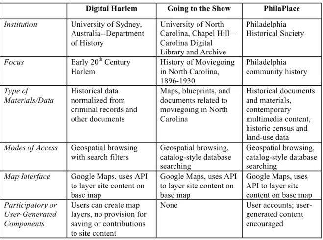
Digital Harlem Going to the Show PhilaPlace
Institution University of Sydney,
Australia--Department of History
University of North Carolina, Chapel Hill— Carolina Digital Library and Archive
Philadelphia Historical Society
Focus Early 20th Century
Harlem
History of Moviegoing in North Carolina, 1896-1930 Philadelphia community history Type of Materials/Data Historical data normalized from criminal records and other documents
Maps, blueprints, and documents related to moviegoing in North Carolina
Historical documents and materials,
contemporary multimedia content, historic census and land-use data
Modes of Access Geospatial browsing
with search filters
Geospatial browsing, catalog-style database searching Geospatial browsing, catalog-style database searching
Map Interface Google Maps, uses API
to layer site content on base map
Google Maps, uses API to layer site content on base map
Google Maps, uses API to layer site content on base map Participatory or
User-Generated Components
Users can create map layers, no provision for saving or contributions to site content
None User accounts;
user-generated content encouraged
Figure 1: Summary of Site Features
audio recordings, or historical data, are assigned spatial metadata which associates this information with a physical location. All three of the above projects make use of the Google Maps API to then project the objects or data onto a map. Additionally, all three projects make use of the process of georectification to adapt historical maps for use as layers on top of the digital map interface. The digital objects are managed in a relational database, with descriptive metadata assigned to each object. Despite great variety in interface design, search options, and content, each of these sites rely upon the Google Maps interface to provide access to and represent content—making the user interface strikingly similar. Differences between the sites revolve around institutional differences and the relationship of the sites to users. Digital Harlem, created by historians, is
designed as a research tool for accessing information about a location and time period. It also allows researchers to build visualizations to illustrate narratives and arguments. Going to the Show is an attempt by a library to build a discrete collection of digitized materials, centered around a theme. This access-oriented collection is enhanced by the addition of interpretive materials authored by a scholar with subject-specific expertise. PhilaPlace is born of a city historical society which seems driven by the principles of public history—a field that emphasizes a direct relationship between historians and the general public. The high level of participatory features of PhilaPlace speak to the
primacy in Public History of encouraging non-academics to engage with history and learn to “think historically” (VandeCreek). Viewed together, it is apparent that these projects— while rooted in divergent professional goals—work towards these goals with the same core technologies and strikingly similar interfaces.
The three projects described above are but a sample of dozens of similar digital projects attempting a spatial approach to the historical. While it is important not to
generalize too much from such a small sample, the three sites described above do provide insight into the broad ‘field' of digital spatial history. The ways in which these projects resemble and differ from one another are informative about both the divergent
professional goals of their creators and the various assumptions upon which such experiments are based. The ubiquity of Google Maps and Google Earth as key
components of such projects speaks to Google's success in making such tools available, free, and easy to use. Prior to the release of Google Earth, GIS tools were expensive and far from open. The pervasion of Google's GIS tools has been a boon to those wishing to easily (and cheaply) incorporate geospatial elements into digital projects. But despite the widespread use of Google mapping tools in these digital projects, there are some who find limitations with Google Maps as the basis for representations of or investigations into history. As Drucker writes, “[s]o naturalized are the Google maps… that they pass as unquestioned representations of "what is". This is the hallmark of realist models of knowledge and needs to be subjected to a radical critique to return the humanistic tenets of constructed-ness and interpretation to the fore.” Drucker's critique hints at a larger issue that lurks within the Digital Humanities: the contentious relationship between the constructivist groundings of the humanities and the seemingly positivistic, scientific orientation of digital tools for representation and visualization.
principles of the natural sciences and a positivistic or rationalist viewpoint. These assumptions run counter to the concepts of knowledge within humanities scholarship as being constructed and interpretive. Indeed, according to Bodenhamer , the use of maps to represent the historical tends to obscure the inherent uncertainty of historical knowledge: “Maps carry the impression of certainty and, especially in easily manipulated digital formats, may remove us further from the circumstances the map represented originally” (227). Drucker argues that tools for representations need to be adapted or re-invented for the humanities—providing mechanisms for visualizing uncertainty. Presner , on the other hand, sees possibilities within the existing tools for exposing and calling attention to the uncertainty of representation (174).
With the increasing number of digital history projects such as these, it is important to consider the degree to which received wisdom and assumptions serve as foundations for new work. Archives, historians, and other professionals working at the intersection of history, space, and digital technologies need to consider the degree to which they rely on accepted practices without interrogating their philosophical underpinnings. Concurrently, each field must also examine the ways in which its professional practices and principles are supported or contradicted by the tools and approaches to such practices.
CONCLUSION
constituting a new discipline or field, some see Digital Humanities as embodying new modalities within existing fields—harnessing technology to question and fundamentally change the way that knowledge is created and shared within the Humanities. The rise in Digital Humanities both coincides with, and contributes to, a conflation of the roles of humanities scholars and librarians and archivists. Specifically, the work of historians and that of professional archivists is becoming increasingly similar and intertwined, as
members of both fields collaborate on digital projects related to history. The use of digital technologies to approach historical research and scholarship is not universally accepted, but those who have embraced these tools tout their capacity to revolutionize engagement with historical knowledge. Meanwhile, spatial technologies, increasingly central to everyday information interactions, have also begun to inseminate Digital Humanities projects. A variety of projects are harnessing Geographic Information Systems (GIS) to approach historical issues. In examining three such projects, we see the similarities of these projects lying mostly in their core technologies—namely relational databases and GIS tools such as Google Maps or Google Earth. These projects are distinguished by their content and approach, but also by the professional goals of their creators. While these sites closely resemble one another, small distinctions (such as the degree of user participation afforded by each site) reflect differences in professional principles and goals between those who design and implement such projects. As these projects expand, it is important to understand that all technologies include assumptions that are often obscured. There is concern that technologies rooted in the natural and social sciences are not always suited to humanities-style inquiry, and that more should be done to emphasize uncertainty in representations of historical situations.
Works Cited
Anderson, S. “Past Indiscretions: Digital Archives and Recombinant History.” Interactive Frictions (2010) : n. pag.
Ayers, Edward L. “The Pasts and Futures of Digital History.” 1999. Web. 25 Mar 2011. Bilton, Nick. “A Technology World That Revolves Around Me.” The New York Times 12
Sept 2010. Web. 11 Apr 2011.
Bobley, Brett. Why the Digital Humanities? National Council on the Humanities, 2008. Web. 28 Apr 2011.
Bodenhamer, David. “History and GIS: Implications for the Discipline.” Placing History : How Maps, Spatial Data, and GIS Are Changing Historical
Scholarship. 1st ed. Ed. Anne Knowles. Redlands Calif.: ESRI Press, 2008. Print. Bolick, Cheryl Mason. “Digital Archives: Democratizing the Doing of History.”
International Journal of Social Education 21.1 (2006) : 122-134. Print.
Dalbello, Marija. “Circulating Culture for the Knowledge Continuum: Living History, Digital History and the History Web.” 2 Nov 2008. Web. 21 Apr 2011.
Drucker, Johanna. “Humanities Approaches to Graphical Display.” 5.001 (2011) : n. pag. Web. 12 Mar 2011.
Haklay, Muki, Alex Singleton, and Chris Parker. “Web Mapping 2.0: The Neogeography of the GeoWeb.” Geography Compass 2.6 (2008) : 2011-2039. Web. 11 Apr 2011.
Mass.: MIT Press, 1995. Print.
Hillier, Amy. “Invitation to Mapping: How GIS Can Facilitate New Discoveries in Urban and Planning History.” Journal of Planning History 9.2 (2010) : 122 -134. Web. 18 Mar 2011.
Howe, B. J. “Reflections on an Idea: NCPH’s First Decade.” The Public Historian 11.3 (1989) : 69–85. Print.
Jessop, Martyn. “The Inhibition of Geographical.” Literary & Linguistic Computing: Journal of the Association for Literary and Linguistic Computing 23.1 (2008) : 39. Print.
Jimerson, Randall. “Embracing the Power of Archives.” American Archivist 69.1 (2006) : 19-32. Print.
Knowles, Anne. “GIS and History.” Placing History : How Maps, Spatial Data, and GIS Are Changing Historical Scholarship. 1st ed. Ed. Anne Knowles. Redlands Calif.: ESRI Press, 2008. Print.
Knowles, Anne, and Amy Hillier. “Preface.” Placing History : How Maps, Spatial Data, and GIS Are Changing Historical Scholarship. 1st ed. Ed. Anne Knowles.
Redlands Calif.: ESRI Press, 2008. Print.
Malpas, Jeff. “New Media, Cultural Heritage and the Sense of Place: Mapping the Conceptual Ground.” International Journal of Heritage Studies 14.3 (2008) : 197-209. Web. 7 Mar 2011.
McPherson, Tara. “Introduction: Media Studies and the Digital Humanities.” Cinema Journal 48.2 (2009) : 119-23. Print.
Makeeva-Roylance. New York: Routledge, 2009. Print.
Nesmith, T. “Seeing Archives: Postmodernism and the Changing Intellectual Place of Archives.” American Archivist 65.1 (2002) : 24–41. Print.
Orwant, Jon. “Our Commitment to the Digital Humanities.” Official Google Research Blog 14 July 2010. Web. 2 Nov 2010.
Presner, Todd. “Digital Geographies: Berlin in the Ages of New Media.” Amsterdamer Beitrëge Zur Neueren Germanistik 75 (2010) : 447-469. Print.
Prochaska, A. “Digital Special Collections: The Big Picture.” RBM: A Journal of Rare Books, Manuscripts and Cultural Heritage 10.1 (2009) : 13. Print.
Rieger, Oya Y. “Framing Digital Humanities: The Role of New Media in Humanities Scholarship.” First Monday 15.10 (2010) : 1. Print.
Rydberg-Cox, Jeffrey. Digital Libraries and the Challenges of Digital Humanities. Oxford: Chandos, 2006. Print.
Scheinfeldt, Tom. “Digital Rocking the Public History Job Market.” Found History 3 Nov 2010. Web. 30 Apr 2011.
Sterling, Bruce. “Dispatches From the Hyperlocal Future.” Wired 26 June 2007. Web. 6 Mar 2011.
Svensson, Patrick. “DHQ: Digital Humanities Quarterly: The Landscape of Digital Humanities.” Digital Humanities Quarterly 4.1 (2010) : n. pag. Web. 6 Mar 2011. VandeCreek, Drew. “‘Webs of Significance’: The Abraham Lincoln Historical
Digitization Project, New Technology, and the Democratization of History.” Digital Humanities Quarterly 1.1 (2007) : n. pag. Web. 6 Mar 2011.