Il LITHOSTRATIGRAPHY
Ila LITHOSTRATIGRAPHY OF THE MOLENAARSGRAAF STUDY AREA IIa.1 The standard-sequence
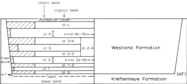
The local sequence of beds, as found in the Molenaarsgraaf study area, has been presented in a gen-eralised way in the left half of Fig. 5. The sand-subsoil, including its clayey top (the loam) and the locally outcropping river dunes, can be distinguished as a separate unit from the superposed sequence of (minero-)clastic and organic beds. Within this sequence, four clastic fluviatile beds are discerned: cl 1, cl 2, cl 3, and cl 4; the superficial clay bed ('cover') is left out of consideration here. These clastic beds could mainly be distinguished because of their alternation with organic beds con-sisting of peat and/or gyttja. As ROELEVELD (1974) and GRIEDE (1978) did in the marine districts in the Northern Netherlands, so too, in this study, the organic layers have been named lithostrati-graphically: ol b as the basal organic bed, ol 1-2, ol 2-3 and ol 3-4 as the orgamc beds between the clastic cl- beds, ol u as the upper organic bed.
clastic beds
orqanic beds
i
\ inundation-cover
Westland F o r m a t i o n /
y/////.
ol uWestland F o r m a t i o n / V\ cl 4— — o l 4 a - 4 b
Westland F o r m a t i o n /
t//////
ol 3-4Westland F o r m a t i o n /
\/]
cl 3 Ol 2 - 4 Westland F o r m a t i o n /y'////.
ol 2-3Westland F o r m a t i o n /
n ver-M
duneli cl 2 ^ — o l 2 a 2 b
-Westland F o r m a t i o n /
\/ / / / / ol 1-2
Westland F o r m a t i o n /
\\ cl 1
Westland F o r m a t i o n /
, V / / / / /
ol bWestland F o r m a t i o n /
basal sond Kreftenheye Formation
v.r\r ;
Fig. 5. Scheme ot' ihe lithostratigraphy in the Molenaarsgraaf study area.
In the mirroring right half of Fig. 5 both local main units are named in terms of the regional litho-stratigraphy, namely the Kreftenheye Formation and the Westland Formation respectively. For references concerning this nomenclature, see ZAGWIJN & VAN STAALDUINEN (1975).
IV' deposits and the 'Tiel O, I, II, Illa and Illb' deposits (Geological Survey: HAGEMAN 1963, ZAGWIJN & VAN STAALDUINEN 1975, p. 47) is not used here. This subdivision is not purely lithostra-tigraphically, but mainly chronostratigraphically defined, namely as chronologie equivalents of the marine 'Calais I - IV' deposits and 'Dunkerque O - Illb' deposits. The objections against the use of these, also mainly chronologically founded lithostratigraphic units have been put forward previously by ROELEVELD (1974). In these matters, one might refer to the International Stratigraphic Guide: the establishment and Identification of lithostratigraphic units should be largely independent of time-concepts (HEDBERG 1976, p. 94). The consequence of all this is that in the discussion of the various deposits belonging to the Westland Formation, besides to the local, informal units men-tioned above, no reference will be made to the units used by the Geological Survey for the whole region.
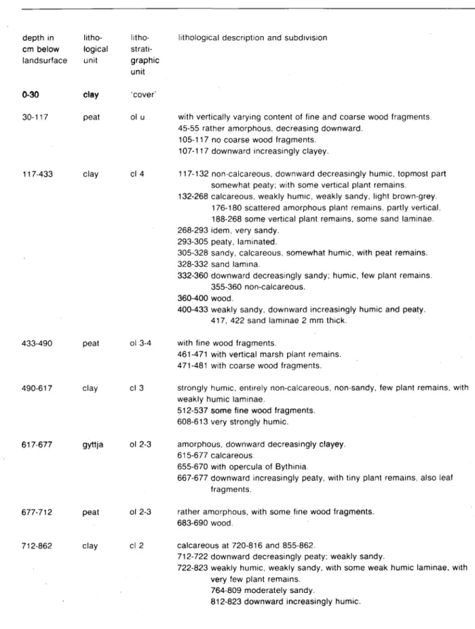
As a tangible example of the lithological succession in the Molenaarsgraaf study area, Table 1 shows the detailed description of the Standard boring (boring Molenaarsgraaf Hl 110). We mentioned pre-viously in Ch. I, that the Standard boring was chosen so as to comprise all distinguished clastic fluviatile (cl-) and organic (ol-) beds as well as the loam bed. This means that no sandy channel fills (stream ridges) and no river-dune sand occur in the boring; these would have resulted in the sequence of clay- and peat beds being incomplete due to erosion of underlying beds or partial non-deposition. In the selected cross-profiles (Figs.*6,*7 and*8) both these elements (stream ridges and river dunes) are however amply represented. The Standard boring is incorporated in the northern part of profile I (Fig.*6).
Ila.2 The Kreftenheye Formation
The loam
The loam is a diamicton of clay and sand, mostly developed as sandy clay, usually with considerable toughness and stickiness. The term loam is set in italic to prevent confusion with the pedogenetic term loam: sand soil with more than 32.5% in the grain size fraction smaller than 50 mu (STICH-TING VOOR BODEMKARTERING 1965), but also: this grain size fraction itself (ibid.), or: 'soil material that contains 7-27% clay, 28-50% silt and less than 52% sand' (SOIL SURVEY MANUAL 1962). The italic setting also indicates that the term involves a lithostratigraphic unit, not only a hthological description. Notwithstanding the objections against this use of the term loam (PONS & BENNEMA 1958, p. 125), the clayey top of the Kreftenheye Formation is indicated as (the) loam in recent litera-ture (VERBRAECK 1974, ZAGWIJN & VAN STAALDUINEN 1975) too. For the sake of its compactness we have maintained the term, although perhaps a more correct expression would be e.g. the 'upper loamy (or clayey) bed of the Kreftenheye Formation'.
The thickness of the loam varies from less than 1 dm to over 1 m and is on the average c. 0.5 m. In the profiles of Figs.*6,7*and*8 the thickness has not been shown, because of the often incomplete gouging of the sticky loam. The depth of the top of the loam varies considerably locally (see e.g. the northern half of profile I, Fig. *6) and amounts on an average to c. 10.5 m below N.A.P. (Dutch Ordnance Datum).
10
Table 1. Lithological description of Standard boring (boring Molenaarsgraaf HlllO).
depth in litho- litho-cm below logical strati-landsurface unit graphic
unit
0-30 clay 'cover'
30-117 peat cl u
lithological description and subdivision
with vertically varying content of fine and coarse wood fragments, 45-55 rather amorphous, decreasing downward.
105-117 no coarse wood fragments. 107-117 downward increasingly clayey.
117-433 clay cl 4 117-132 non-calcareous. downward decreasingly humic, topmost part somewhat peaty; with some vertical plant remains.
132-268 calcareous, weakly humic, weakly sandy, light brown-grey. 176-180 scattered amorphous plant remains, partly vertical. 188-268 some vertical plant remains, some sand laminae. 268-293 idem, very sandy.
293-305 peaty, laminated.
305-328 sandy, calcareous, somewhat humic, with peat remains. 328-332 sand lamina.
332-360 downward decreasingly sandy; humic, few plant remains. 355-360 non-calcareous.
360-400 wood.
400-433 weakly sandy, downward increasingly humic and peaty. 417, 422 sand laminae 2 mm thick.
433-490 peat ol 3-4 with fine wood fragments.
461-471 with vertical marsh plant remains. 471-481 with coarse wood fragments.
490-617 clay cl 3 strongly humic, entirely non-calcareous, non-sandy, few plant remains, with weakly humic laminae.
512-537 some fine wood fragments. 608-613 very strongly humic.
617-677 gyttja ol 2-3 amorphous, downward decreasingly clayey. 615-677 calcareous.
655-670 with opercula of Bythinia.
667-677 downward increasingly peaty, with tiny plant remains, also leaf fragments.
677-712 peat ol 2-3 rather amorphous, with some fine wood fragments, 683-690 wood.
712-862 clay cl 2 calcareous at 720-816 and 855-862.
712-722 downward decreasingly peaty: weakly sandy.
722-823 weakly humic, weakly sandy, with some weak humic laminae, with very few plant remains.
764-809 moderately sandy.
823-830 strongly peaty, with vertical plant remains, 830-847 strongly humic, non-sandy, very few plant remains. 847-862 moderately humlc, non-sandy, very few plant remains.
862-875 peat ol 1-2 amorphous, compact, weakly clayey, with few fine wood fragments. 870-875 moderately clayey.
875-928 clay cl 1 calcareous 883-924; witti few plant remains. 875-878 strongly fiumic. weakly peaty.
878-905 moderately fiumic, witfi indistinct humic laminae. 905-919 weakly humic.
919-925 strongly humic.
925-928 peaty, with some vertical wood fragments.
928-961 gyttja ol b amorphous, clayey.
928-935 peaty, with some fine wood fragments. 938-951 with opercula of Bythinia.
961-966 peat ol b amorphous. 963-966 clayey.
966-1040 clay 'loam' sandy ('loamy')
1040- sand basal
sand
coarse.
In most borings, the loam becomes sandier downward, and the transition to the underlying, rather coarse 'basal sand' (see the scheme in Fig. 5) is often very gradual. Locally, remarkably coarse sand was found in the upper few cms of the loam.
Outside the Western Netherlands perimarine fluviatile coastal plain the top of the Kreftenheye For-mation has been found developed as loam in many places; a few of these will be mentioned. SCHELLING (1951) and PONS (1957) described the loam in the Eastern Netherlands stream area of Rhine and Meuse. There too, the thickness of the layer varies considerably, and is on the average 1 to 1.5 m. In the northern part of the IJssel valley, WIGGERS (1955) found the loam bed to be only a few cms to 2 dm thick.
SCHELLING (1951, p. 94) and PONS (1957, p. 15) also found coarse sand in the upper part of the loam. They regard this as mainly of eolian origin. We come back to this in Ch. IVc.
The river-dune sand
The lithostratigraphic position of the river-dune sand in the top of the Kreftenheye Formation is shown in Fig. 5. The larger part of the /oaw-surface is not covered by dune sand; on the other hand, it is not certain that loam will always be found below the dune sand, although this was esta-blished in a limited number of — sufficiently deep — borings (see Fig. 37).
12
The river-dune sand can be distinguished from the channel-filling sand of the Westland Formation mainly by means of its darker colour, caused by a higher content of dark, heavy minerals, and also by means of the absence of micas and nearly everywhere of lime. The fluviatile 'basal sand', that must have been the source material during the dune building, likewise contains many dark minerals (VERBRAECK 1974, p. 4). Also in the northern part of the IJssel valley, source material and river dunes (both also belonging to the Kreftenheye Formation) are characterised by this mineralogie composition, rendering the sand a 'variegated colour' (WIGGERS 1955, p. 39). A concentration of the heavy (dark) minerals relative to the source material, as occurs in the formation of (river-)dunes according to REINECK & SINGH (1975, p. 262), is supposed by us, but has not been investigated. For details concerning granulometry and sedimentary structures we refer to VERBRAECK (1974 and 1970 respectively).
IIa.3 The Westland Formation
Lateral continuity
Most of the clastic minerogenic fluviatile beds (cl-) and organic beds (ol-) in the local Hthostratigra-phy of the Westland Formation can be traced nearly continuously in the illustrated cross-sections (Figs.*6,*7 and*8). Interruptions are virtually only found where guUies have eroded underlying beds and where emerging river dunes of the Kreftenheye Formation have prohibited the deposition of a part of the Westland Formation (see also Ch. IIa.1). The minor, very thin, organic horizons within the clastic beds cl 2 and 4 (ol 2a-2b and ol 4a-4b respectively; see the scheme in Fig. 5) have a strongly discontinuous lateral distribution.
Lx)>ver and upper boundary of the formation
The lower boundary of the Westland Formation is formed everywhere by the upper boundary of the Kreftenheye Formation. The latter's relief has naturally influenced the sedimentary development of the Westland Formation particularly at the river dunes. An example of this can be seen in profile III (Fig.*8) around boring H2106: due to the presence of the river dune, clastic bed cl 1 has not been deposited, and clastic beds cl 2, 3 and 4 are developed more thinly than outside the river-dune peri-meter. In addition, outside the river dunes the relief of the Kreftenheye Formation has exerted a certain influence on the sedimentation of the Westland Formation, especially so where depressions are present in the top of the former. Such a depression can be seen in the northern end of profile I (Fig.*6). lts influence is expressed among others in the lithology of the lower organic beds of the Westland Formation. These are developed largely as gyttja, so in a deeper position with respect to the water table than the Uthostratigraphically corresponding peat beds.
The upper boundary of the Westland Formation, the present land-surface, is very flat and consists of a continuous, only few dm thick clay bed, the so-called 'Alblasserwaard cover' (LOUWE
Clastic deposits
The sedimentary material of the Westland Formation in the study area is very varied: weakly to strongly clayey sand, weakly to strongly sandy clay, weakly to strongly humic clay, weakly to strongly peaty clay, weakly to strongly clayey peat (wood peat and Phragmites peat) and (detritus-)-gyttja. First the clastic (clay and sand) deposits will be discussed.
Sandy, calcareous channel-fiUing deposits (the stream ridges, see Ch. Ia) have been found, within the study area, mainly in the fluviatile clastic beds cl 2 and cl 4. This is clearly illustrated by profile I (Fig.*6), a section perpendicular to the general stream direction of the filled channels. These sand bodies provide the stable framework between the clay- and peat beds which are instead subject to compaction. Although these channel fiUs have been completely bored through in only few places (DE FRETES 1979), their lower boundary is supposed to he on the compaction-free Kreftenheye Forma-tion in most cases. This is very plausible in the case of the stream ridges belonging to clastic bed cl 2. as the top of these lies only c. 4 m above the Kreftenheye Formation (see e.g. the two channel fills at borings H1(X)9 and Hl541, Fig.*6). VERBRAECK mentions that the Schoonrewoerd stream ridge (belonging to bed cl 4) lies also on the Kreftenheye Formation, at least for the stretch near Molenaarsgraaf (pers. comm. in LOUWE KOOUMANS 1974, p. 95). A cross-section of this stream ridge can be seen at boring Hl 114 in profile I (Fig.*6).
The clay beds that have been deposited from these gully systems belonging to the units cl 2 and cl 4 are generally weakly to moderately humic and non- or weakly, but at some places moderately, sandy (Figs.*6 and'7). Both beds have a nearly continuous distribution in the study area. At many places they show a vertical uniformity; according to ALLEN (1965, p. 150 f.) this is characteristic for flood-basin deposits.
Clearly, the fluviatile clastic beds cl 1 and cl 3 have been developed difi'erently within the study area from beds cl 2 and cl 4. Cl 1 is a thin, discontinuous, usually sand-free, weakly to moderately humic clay bed. Cl 3 is less continuous and less sandy than beds cl 2 and cl 4. Cl 3 is generally moderately to strongly humic; the bed is at several places peaty or traceable as a clayey bed in the peat (see e.g. boring H2106, Fig.*8 and H1009, Fig.*6 respectively). This variation in thickness and facies is to a large extent coimected with the facial variations in the underlying bed cl 2: above a stream ridge of cl 2, cl 3 is generally strongly peaty and thin, or absent (see especially profile I, bor-ings Hl009 and Hl541). Where, in such a case, bed cl 3 has not been deposited, the under- and overlying peat beds (ol 2-3 and ol 3-4 respectively, see Fig. 5) are not separable, and are taken together as the peat complex ol 2-4.
Organic deposits
The organic beds (ol-) of the Westland Formation are developed in the Molenaarsgraaf study area mainly as peat, but partly also as gyttja. The beds ol b, ol 1-2, ol 2a-2b, and the basis of ol 2-3 and of ol 3-4, consist at many places of Phragmites peat, or at any rate peat with remains of Phragmites and other water- and marsh plants: the German S'C/KV/" (OVERBECK 1975, p. 88). The beds ol 2-3 (except base and top), ol 3-4 (except the base) and ol u are developed in most places as wood peat. Thus the deeper organic beds of the Westland Formation in the study area appear to consist mainly of Phragmites peat, the higher ones mainly of wood peat. A similar bipartition was found by VERBRAECK (1970, p. 75) in the eastern part of the perimarine fluviatile coastal plain.
14
from the works of VON POST and of LUNDQVIST). The material is light- to brownish green, some-what elastic, and consisting mainly of fine-grained structureless organic material. It contains varying quantities of clay, is mostly somewhat calcareous, and contains shell remains of freshwater snails (Lymnea, Planorbis, opercula of Bythinia). A useful field characteristic is also provided by very tiny, shiny cleavage planes. In general, only very small quantities of coarse plant remains are present in this gyttja. Where there are larger quantities, the sediment may be regarded as the above-mentioned Grobdetritus-gyttja; in such cases the transition (lateral or vertical) to peat is gradual.
Detritus gyttja is regarded as a deposit of all sorts of decayed vegetable and animal material on a lake-bottom. Fine detritus gyttja is mainly formed in the deeper, quiet parts of a lake, coarse detritus gyttja in the shallower, less quiet parts (OVERBECK 1975, p. 87). wiGGERS (1955, p. 66 f.) describes detritus gyttja beds in the subsoil of the IJsselmeer area and has evidence that the deposit there consists partly of the remains of eroded, older peat beds ('peat-detritus')- PONS & VAN OOSTEN
(1974, p. 21) ascribe a similar genesis to the organic deposits at the bottom of the recent lakes in the peat areas of the province of Noord-Holland. We think that this component of detrital peat is vir-tually absent in the gyttja of our study area (see further in Chs. III and V).
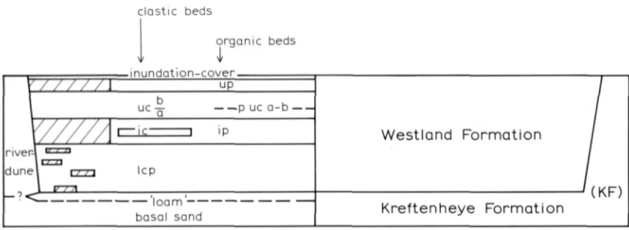
Ilb LITHOSTRATIGRAPHY OF THE LEERDAM STUDY AREA llb.1 General comparison with the uthostratigraphy
of the Molenaarsgraaf study area
The outline of the Uthostratigraphy of the Leerdam study area is in its main characteristics similar to that of the Molenaarsgraaf area (compare Figs. 11 and 5). The Kreftenheye Formation is represented by the same components, namely the 'basal sand', the loam, and the river-dune sand. The Westland Formation is here also subdivided into elastic fluviatile beds and organic beds. To prevent confusion, the units of the Westland Formation have been coded for the Leerdam area in a different way from those of the Molenaarsgraaf area. Instead of numbering of the beds, the adjec-tives lower (1), intermediate (i) and upper (u) have been used here. Since all organic beds are developed almost exclusively as peat, the code p (peat) is used instead of o (organic). The main units of the Westland Formation are lep, ip, uc and up. The unit lep (lower elastic and peat beds) is a complex of clay beds with irregularly intercalated peaty beds and a broad sandy channel fill. This mainly elastic unit is nearly everywhere separated by a peat bed ip (intermediate peat bed) from the overlying elastic unit uc (upper elastic bed). As is the case with the peat bed ol u in the Molenaars-graaf area, here too the sequence of elastic and organic beds is closed towards the top by the peat bed up (upper peat). Also, above it there is a usually thin clay cover, comparable to the 'Alblasserwaard cover' at Molenaarsgraaf.
The lithological variation within both formations (Kreftenheye Formation and Westland Formation) is about the same as in the Molenaarsgraaf area. An important difTerence is however that in the Leerdam area the peat beds are generally more amorphous (i.e., contain less macroscopically recog-nizable plant remains) and the clay beds have at several places a somewhat tougher consistency than at Molenaarsgraaf.
clastic beds
orqonic beds
i
, , inunaation cover ,
Westland Formation
-'(KF) \ u c - p uc a -b
Westland Formation
-'(KF)
\///// Westland Formation
-'(KF)
\///// r IL 1 ip Westland Formation
-'(KF)
\///// Westland Formation
-'(KF) river-l • = '
dune\ n-n lep 1 v-n\
Westland Formation
-'(KF)
basQl sand Kreftenheye Formation
-'(KF)
Fig. II. Scheme of the lithostratigraphy in the Leerdam study area.
IIb.2 The Kreftenheye Formation
The surface of the Kreftenheye Formation has, as at Molenaarsgraaf, a considerable relief, particu-larly where the river dune is concemed (the Schalkse donk, see Ch. Ib; the place of outcrop of this dune lies outside the profile of Fig.* 10, see the location in Fig. 4). The relief of the river dune (see the southern part of the profile, Fig.* 10) compares well with that of the western river dune complex in the Molenaarsgraaf study area (see profile III, Fig.* 8). At the foot of the dune (at borings S341 and S342 in the profile) the dune sand lies on top of the loam. The depth of the top of the loam varies in the profile with a magnitude comparable to that in e.g. the northem part of profile I of the Molenaarsgraaf area (see Fig.*6). The depth amounts on an average to c. 6 m below N.A.P., which is more than 4 m higher than in the Molenaarsgraaf area 20 km downstream.
A depression in the top of the Kreftenheye Formation (boring S322, in the northern end of the profile, Fig.*10) descends to c. 10.25 m below N.A.P. Part of this depression is filled with dune sand. Also in the southern end of the profile, dune sand seems to fill a depression in the /oaw-top of the Kreftenheye Formation.
IIb.3 The Westland Formation Lower deposits
16
The variation in thickness of unit lep is flrstly connected with the relief of the top of the Kreftenheye Formation (compare e.g. boring S364 with boring S322 in the profile, Fig. *10). Secondly, the unit has of course a considerable thickness where, in the middle part of the profile, it is developed as a stream ridge (channel fill). This stream ridge is one of the most conspicuous fossil phenomena of the area; the profile shows a cross-section from boring S355 up to S361, over a dis-tance of c. 500 m. Under the profile-type code A3k, this stream ridge, the Middelkoop stream (VERBRAECK 1970, p.84), occupies an important place on the before-mentioned geological map 38 Oost. The (completely buried) stream ridge has a strongly sinuous course on this map, and branches off" towards the West.
The sandy nature of unit lep, where it rests on the buried river dune in the middle part of the profile (Fig.* 10), should not be cormected to distinct channel deposition, but can be explained by slight ero-sion of the underlying dune sand.
Unit lep of the Leerdam area can hthostratigraphically be correlated with the layer-sequence ol b + cl 1 + ol 1-2 + cl 2 in the Molenaarsgraaf area (see also Fig. 5). It goes without saying that the base of both bed complexes is correlative - in both areas it involves the boundary between the Kreftenheye Formation and the Westland Formation. The upper boundary of lithostratigraphic unit cl 2 in the Molenaarsgraaf area is, via profiles D and E belonging to the geological map 38 Oost and the map itself (VERBRAECK 1970), well traceable to the top of the bed in which the west-ward branching Middelkoop stream ridge is situated. This means that also the top of both bed complexes is hthostratigraphically correlative.
Upper and inteimediate deposits
Of the two main clastic fluviatile beds in the Westland Formation of the Leerdam area, the above-discussed unit lep forms the lower one, the unit uc (upper clastic bed, see Fig. 11) the upper one. Profile IV (Fig.* 10) is, also with regard to the stream ridges belonging to this bed uc, perpendicular to the stream direction. The bed's facies and thickness change rapidly with distance from the stream ridges: the clay bed is thiimer and peatier further from the stream ridge. The bed is subdivided into uc a and uc b by an intercalated peaty horizon (bed) p uc a-b (see Fig. 11). This horizon is locally only weakly peaty and remarkably black; on these places, it may perhaps be compared to the so-called lak (lacquer) layers, as described by DE BOER & PONS (1960, p. 60) and DE BAKKER & EDELMAN-VLAM (1976, p. 123).
The stream ridge at the northem end of profile IV (at boring S320), with its relatively strong topo-graphic expression, is known as the Schoonrewoerd stream ridge, the smaller one at the southern end of the profile as the Schalk stream ridge (DE BOER & PONS 1960, p. 25; VERBRAECK 1970, p. 85; LOUWE KOOIJMANS 1974; to VINK (1954) the Schoomewoerd stream ridge was known as the 'Over-lek stream'; the names derive from small villages located in the study area). Both stream ridges belong hthostratigraphically to unit uc. As previously mentioned (Ch. Ib), the Schoonrewoerd stream ridge forms the topographically visible link between the Leerdam and the Molenaarsgraaf study areas (cf. Figs. 3 and 4; see also LOUWE KOOIJMANS 1974, fig. 18). In the Molenaarsgraaf area, this stream ridge forms part of clastic bed cl 4. Due to this, unit uc of the Leerdam area is hthostra-tigraphically correlative with unit cl 4 of the Molenaarsgraaf area.
For this region VERBRAECK (1970, p. 85) indicates that the Schoonrewoerd stream has incised into the Kreftenheye Formation but the Schalk stream has not. In profile IV these data have been processed.
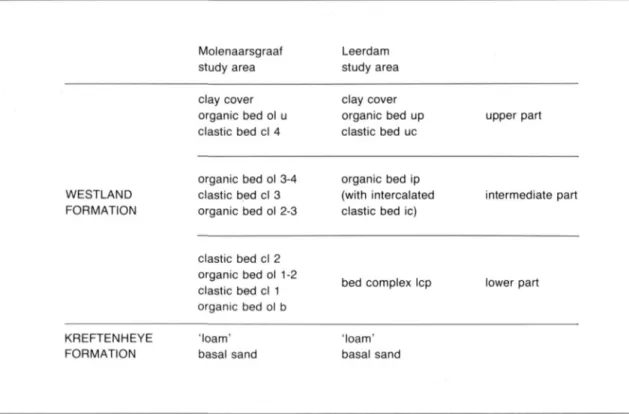
Table 2. Correlation of the lithostratigraphies of the Molenaarsgraaf and the Leerdam study areas. Compare with Figs. 5 and 11.
Molenaarsgraaf Leerdam
study area study area
clay cover clay cover
organic bed ol u organic bed up upper part clastic bed cl 4 clastic bed uc
organic bed ol 3-4 organic bed ip
WESTLAND clastic bed cl 3 (with intercalated intermediate part FORMATION organic bed ol 2-3 clastic bed ie)
clastic bed cl 2 organic bed ol 1-2
clastic bed cl 1 bed complex lep lower part organic bed ol b
KREFTENHEYE 'loam' 'loam'
FORMATION basai sand basaI sand
By the lithostratigraphical correlations between the Leerdam and the Molenaarsgraaf study areas indicated above (namely the correlation of the top of lep with the top of cl 2 and the correlation of uc with cl 4), peat bed ip (intermediate peat) of the Leerdam area can be correlated with the organic bed complex ol 2-4 of the Molenaarsgraaf area (compare the schemes in Figs. 5 and 11).
In peat bed ip a thin clay bed locally occurs, the intermediate clastic bed ie, as can be seen in the profile (Fig.*10). It seems plausible to conclude from a comparison of both lithostratigraphic schemes (Figs. 5 and 11) that this clay bed ie in the Leerdam area is correlative with clay bed cl 3 in the Molenaarsgraaf area.