7
Traffic and Transportation
7.1
Introduction
This chapter describes the likely traffic and transportation impacts associated with the construction and operation of the proposed development. A detailed
description of the proposed development in relation to traffic and transportation is provided in Section 7.4.
This transportation assessment has considered likely significant effects during both the construction and operation of the proposed development. However, it is envisaged that it is during the construction of the proposed development that the likely impact on the various transportation networks will be greatest.
This report will present the receiving transport environment including reporting on traffic counts carried out on the surrounding street network. The projected increase in traffic associated with the operation of the proposed development and its likely significant effects on the receiving transportation networks. The likely phasing and scheduling of the proposed construction works is presented and their likely significant effects on the receiving environment. Finally, any mitigation measures which will assist in reducing the significant effects of the proposed development on the surrounding transportation network is presented.
7.2
Assessment Methodology
The following section presents the assessment methodology used in this transportation assessment.
7.2.1
Study Area
The study area considered as part of this transportation assessment is illustrated in Figure 7.1 and includes the following primary streets/ roads;
• North Quay;
• South Quay;
• Arklow Bridge;
• Harbour Road;
• Abbey Street;
• Main Street; and
Figure 7.1: Study Area
The study area in Figure 7.1 is considered to be the primary zone of influence with respect to the management of traffic during the construction of the proposed development and is the area most likely to experience temporary changes in traffic flow during construction. As outlined in Section 4.6 of Chapter 4, the expected increase in traffic associated with the operation of the proposed development is expected to be very limited as the number of future employees is estimated at only 3-5 persons and regular deliveries/exports to the WwTP site will be minimal. This level of employment and the operational traffic associated with WwTP is
expected to have little or no impact on the surrounding road network.
7.2.2
Traffic Count Data
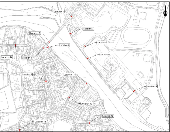
Traffic counts were carried out in May 2017 and the traffic count locations are shown in Figure 7.2. The traffic counts were carried out to establish link flows only on an all day basis.
Figure 7.2: Traffic Count Locations
The first traffic survey was carried out from Thursday 4 May 2017 at 9:00 to Thursday 11 May 2017 at 14:00. Count information was obtained at the following locations.
• Location 1: R772-646 Ferrybank;
• Location 2: L6909-0 Bridgewater Road;
• Location 3: L6909-5 Off North Quay beside Aldi store;
• Location 4: L6909-10 North Quay; and
• Location 5: L6909-35 Marina.
The second traffic survey was carried out from Friday 12 May 2017 at 10:00 to Monday 22 May 2017 at 10:00. Count information was obtained at the following locations.
• Location 6: L6907 South Quay;
• Location 7: R775-656 Bridge Street;
• Location 8: R772-652 Arklow Bridge;
• Location 9: L2901-15 Lower Main Street; and
The third traffic survey was carried out from Tuesday 23 May 2017 at 09:00 to Wednesday 31 May 2017 at 16:00. Count information was obtained at the following locations.
• Location 11: L6907-30 South Quay;
• Location 12: L6909-20 Harbour Road;
• Location 13: L2901-90 Abbey Street; and
• Location 14: R772-662 Main Street.
7.2.3
Future Year Traffic Growth Rates
Future traffic growth on the external road network is based on Transport Infrastructure Ireland’s growth rates1 for the Wexford Region. Based on Table
5.3.2. of the guidelines1 (as presented in Figure 7.3) the recorded traffic flows have been increased by the central growth rates to establish Year 2020 base year traffic flows.
Year 2020 is expected to be the busiest year with respect to construction activity on the surrounding street/road network and thus has been used to present the likely significant effect of the construction of the proposed development.
However, should the proposed development be delayed, there will be no change in the projected increase in traffic and resultant transport assessment as described herein.
Figure 7.3: Future traffic growth (Source: Table 5.32 of the guidelines1)
1 Transport Infrastructure Ireland (2016) Project Appraisal Guidelines for National Roads Unit 5.3
7.2.4
Traffic Generation
The projected change in traffic flows associated with the construction and operation of the proposed development are based on the following information:
• The volume of construction traffic activity is based on, the scale of the individual construction phases, the level of deliveries on site, the removal of soil/ waste from the site in addition to staff and ancillary traffic movements (i.e. servicing, visitors, etc..); and
• The volume of operational traffic activity is based on the number of staff employed and the volume of servicing/maintenance (i.e. sludge removal, etc.) trips associated with the proposed development.
7.2.5
Traffic Distribution
The distribution of generated traffic both operational and construction will reflect the existing distribution of traffic recorded by the traffic counts carried out on the local road network. In addition, the distribution of construction traffic is based on the following:
• All construction deliveries to the WwTP and the sewer network north of the Avoca River will access and egress the works area from Junction 20 on the M11 Motorway.
• All construction deliveries to the sewer network south of the Arklow Bridge will access the works area from Junction 21 on the M11 Motorway and egress via Junction 20 on the M11 Motorway.
7.2.6
Time Periods Assessed
The time periods assessed as part of this transportation assessment include the 08:00-09:00 period (i.e. during the morning peak period), the 17:00 - 18:00 period (i.e. during the evening peak period) and on an all-day basis (i.e. 24 hour period). In terms of future assessment years it is proposed to assess the proposed
development for Year 2020 as this is the expected busiest period during the construction. The operational assessment will be based on Year 2022 flows.
7.2.7
Site Visit
A site visit was undertaken on 11 July 2018 to develop an appreciation of the movement of traffic and pedestrians within the study area.
7.2.8
Consultation
Wicklow County Council was consulted in early March 2018 during the
development of the traffic management plans to facilitate the construction of the proposed development. In principle, they are in agreement with the proposed traffic management plans, subject to the finalisation and submission of these plans on appointment of a contractor.
A further meeting was held with Wicklow County Council in mid-June 2018 to discuss the proposed diversion of traffic from North Quay to Seafield Avenue during the course of the construction of the proposed development.
7.2.9
Impact Assessment Methodology
The significance of effects has been assessed based on the criteria presented in Table 7.1 and has been based on the projected change in prevailing travel conditions which has regard to the EPA draft guidance2 and with reference to professional judgement of the author who has more than 20 years’ experience in undertaking traffic and transportation assessments.
Table 7.1: Assessment Criteria
Significance of Effects Topic Specific Criteria
Imperceptible No perceived impact on prevailing travel
conditions
Not Significant A small change in traffic flows without
causing a real change in travel conditions
Slight Effects A change in traffic flow resulting in a minor
change in travel conditions
Moderate Effects A change in traffic flows resulting in a
modest change in travel conditions
Significant Effects A marked change in travel conditions
resulting in long delays to traffic
Very Significant Effects A significant change in travel conditions
resulting in very long delays to traffic
Profound Effects A major change in travel conditions resulting
in the breakdown in traffic flow and significant delays to traffic
7.3
Baseline Conditions
7.3.1
Site Location
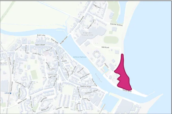
The WwTP site is located to the north east of Arklow and is approximately 1.5km from the centre of the town. The site is located adjacent to the shore and is
bounded by North Quay on both its western and southern boundaries. The location of the WwTP site is presented in Figure 7.4.
2 Environmental Protection Agency (2017) Draft Guidelines on the Information to be contained in
Figure 7.4: Location of proposed WwTP
7.3.2
Local Road Network
A brief description of the local road/street network in the vicinity of the proposed development is provided in Sections 7.3.2.1 - 7.3.2.8.
7.3.2.1
Ferrybank
Ferrybank is the primary route serving the northern side of Arklow and is the main road connecting Arklow to Junction 20 (Templerainey) on the M11. Ferrybank is a two-way roadway and directly serves adjacent residential
properties. The roadway has good pedestrian facilities with footpaths located on both sides of the roadway and there is a pedestrian crossing outside Abercorn Masonic Hall on the two-way Ferrybank Road.
7.3.2.2
North Quay
North Quay is the primary access route serving the proposed WwTP. The junction of Ferrybank and North Quay is controlled via a roundabout and is a relatively busy intersection as North Quay also provides access to the Bridgewater Shopping Centre. The roadway is a single carriageway road with a footpath provided along one side of the roadway only. North Quay generally serves a combination of industrial and commercial properties.
7.3.2.3
South Quay
South Quay is a two-way roadway primarily serving residential properties. The roadway is generally narrow in width and has only intermittent footpath provision.
The northern end of South Quay operates one-way northbound and there are no footpaths provided along this section of roadway. The junction of Bridge Street and South Quay is a give-way junction but traffic is not permitted to access South Quay from Bridge Street.
7.3.2.4
Bridge Street
Bridge Street connects Main Street with Arklow Bridge. The street is two-way and supports on-street commercial and retail premises, no parking is permitted along Bridge Street. Bridge Street has footpaths located on both sides of the roadway and also has a pedestrian crossing provided close to its junction with Main Street.
The junction of Bridge Street/ Lower Main Street is non-standard with traffic travelling from Main Street having to give-way to traffic travelling between Bridge Street and Lower Main Street. This junction is a relatively busy location for both vehicular and pedestrian traffic.
7.3.2.5
Abbey Street
Abbey Street serves the south west districts of Arklow and also provides access to Junction 21 on the M11 Motorway. The street is two-way and supports mainly residential properties. The street has footpaths on both sides of the roadway and also supports some on-street parking.
7.3.2.6
South Green
South Green connects South Quay with Lower Main Street. The street is residential in nature, is two way and supports on street parking.
7.3.2.7
Harbour Road
Harbour Road connects Abbey Street to the southern end of South Quay. The street is two-way, however the connection to Abbey Street requires the utilisation of a system of one-way streets encompassing Lower Main Street/ Back Street and Old Chapel Street. The roadway is generally wide in nature, supports on-street parking and has footpaths provided on both sides of the roadway.
7.3.2.8
Main Street
Main Street connects Wexford Road with Bridge Street, via Upper Main Street. The street is two-way and supports on street commercial and retail premises. The street has footpaths on both sides of the roadway and supports on-street parking along one side of the roadway.
As noted previously traffic on Main Street has to yield to traffic on the Bridge Street- Lower Main Street route as part of the existing management of traffic.
7.3.3
Public Transport Network
Arklow is served by a rail service with Arklow train station located approximately 10 minutes’ walk from the junction of Main Street/ Bridge Street. In addition, Arklow is served by regional bus services connecting it with the surrounding towns and cities including:
• Intercity Route 2: Wexford to Dublin also serving Gorey, Enniscorthy and Wexford; and
• Regional Route 133: Dublin to Arklow serving Rathnew, Wicklow, Bray. The location of the train station and the primary bus route in Arklow is presented in Figure 7.5.
Figure 7.5: Public Transport Network
7.3.4
Existing Traffic Patterns
In order to assess the potential impact of the proposed development on the local road network an examination of the existing traffic flows was necessary. Traffic counts were carried out during May 2017 at the following locations as illustrated in Figure 7.6.
Arklow Wastewater Treatment Plant Primary
Bus Route
Arklow Train Station
Figure 7.6: Traffic Count Locations
• Location 1: R772-646 Ferrybank;
• Location 2: L6909-0 Bridgewater Road;
• Location 3: L6909-5 Off North Quay beside Aldi store;
• Location 4: L6909-10 North Quay;
• Location 5: L6909-35 Marina;
• Location 6: L6907 South Quay;
• Location 7: R775-656 Bridge Street;
• Location 8: R772-652 Arklow Bridge;
• Location 9: L2901-15 Lower Main Street;
• Location 10: L6905-20 South Green;
• Location 11: L6907-30 South Quay;
• Location 12: L6909-20 Harbour Road;
• Location 13: L2901-90 Abbey Street; and
• Location 14: R772-662 Main Street.
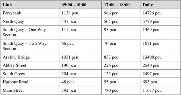
Table 7.2 presents the morning peak (09:00-10:00), evening peak (17:00-18:00) and weekday daily traffic flows for the key streets in the vicinity of the proposed development.
Table 7.2: Existing Traffic Flow
Link 09:00 - 10:00 17:00 – 18:00 Daily
Ferrybank 1128 pcu 966 pcu 14726 pcu
North Quay 437 pcu 504 pcu 5779 pcu
South Quay – One Way Section
111 pcu 93 pcu 1369 pcu
South Quay – Two Way Section
66 pcu 70 pcu 1071 pcu
Arklow Bridge 1031 pcu 837 pcu 13498 pcu
Abbey Street 190 pcu 226 pcu 2540 pcu
South Green 204 pcu 122 pcu 2497 pcu
Harbour Road 48 pcu 55 pcu 693 pcu
Main Street 792 pcu 780 pcu 11677 pcu
Note: pcu = passenger car units
From the information in Table 7.2, it can be seen that the busiest routes include Ferrybank, Arklow Bridge and Main Street, with lower traffic flows using the remaining streets particularly on the south side of the Avoca River. The northern section of North Quay is relatively busy due to the presence of the Bridgewater Shopping Centre.
7.3.5
Committed Development
It is possible that the construction of the proposed development will be carried out at the same time as the proposed Arklow Flood Relief Scheme. The proposed Arklow Flood Relief Scheme includes works within the river itself, to the Arklow Bridge and works along both the North Quay and South Quay.
As noted previously the recorded baseline traffic flows have been increased by the suggested growth rates as presented by Transport Infrastructure Ireland1 (Refer to Table 7.1). The inclusion of these growth rates reflects the potential increase in traffic on the surrounding road network from committed schemes in the general Arklow area.
7.4
Characteristics of the Proposed Development
7.4.1
Introduction
The following sections presents the proposed development and the likely changes to the existing transportation networks needed to accommodate the construction of the proposed development. In transportation terms, the construction of the
proposed development can be divided into two primary phases, first the
construction of the WwTP itself and the second the construction of the proposed interceptor sewer network and ancillary development to serve this new WwTP. The operation of the WwTP will be considered separately.
7.4.2
Wastewater Treatment Plant
The location of the WwTP is presented in Figure 7.7 along with the primary access route to the WwTP site, which will be via Mill Road. It is envisaged that this route will be used during both the operation and construction, however there may be some diversion of traffic along the North Quay during construction to facilitate the construction of the proposed interceptor sewer in this area. Further details of the proposed construction sequence associated with the sewers is presented in Section 7.4.3.
Figure 7.7: Primary Access Route – Arklow Wastewater Treatment Plant
7.4.2.1
Construction Phase
The construction of the WwTP at the Old Wallboard site at Ferrybank is expected to take approximately 42 months to complete and it is envisaged that the
construction works will employ up to 120 persons during the peak construction period, which will last approximately 12 months.
There will only be limited parking provided at the WwTP site for site vehicles, management and occasional visitors with the remaining parking demand
accommodated on either the surrounding road network or temporarily within an adjacent parking area secured by the contractor.
The WwTP will also include bicycle parking, changing rooms and showers to be provided for construction workers. Finally, an on-site canteen is proposed to minimise the movement of traffic between the site and the surrounding area during lunch and break times.
Arklow Wastewater Treatment Plant
7.4.2.2
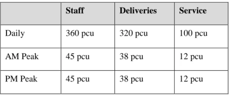
Traffic Generation
During the peak construction period, it is expected that the following volume of traffic will be generated by the proposed construction works based on the following key assumptions:
• 90% of construction staff traffic will arrive by car with a car occupancy of 1.2 persons.
• 50% of all construction staff traffic will arrive and leave during the traditional peak hour periods.
• The busiest construction period is likely to be during the revetment upgrade and the deep excavation required for the treatment plant. During this circa 3 month time period the estimated total volume of excavation and fill required is approximately 57,000m3.
• The delivery of fill and excavation material from the site will be via rigid trucks (9m3) and the calculation of truck movements is based on a 5 day operation with a 10 hour working day.
• The average delivery of fill and excavation material has been increased by 20% to represent some potential peaking in the arrival and departure of trucks to and from the site.
• All Heavy Goods Vehicles have been converted to passenger car units based on the following ratio: 1 HGV equals 2.3 passenger car units.
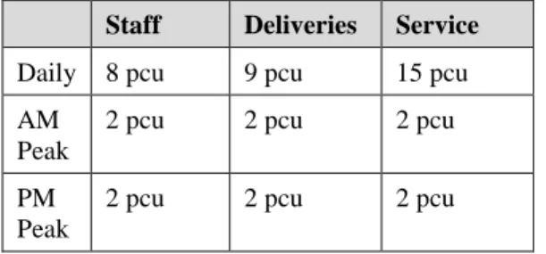
Table 7.3: Traffic Generation – Construction Phase
Staff Deliveries Service
Daily 360 pcu 320 pcu 100 pcu
AM Peak 45 pcu 38 pcu 12 pcu
PM Peak 45 pcu 38 pcu 12 pcu
pcu = passenger car units.
7.4.2.3
Commissioning Works
As part of the commissioning of the WwTP some additional works will be
required to the proposed interceptor sewer network to transfer flows from existing sewers to the proposed interceptor sewers. This will include the laying of short sections of spur pipelines from the new sewers and connecting these to the existing sewers. The sections of existing sewer to be abandoned will typically be pumped within concrete to form a plug at either end of the line.
The projected increase in traffic associated with the commissioning works will be less than that noted during the peak construction periods associated with the construction of the WwTP itself.
7.4.2.4
Operational Phase
On completion of the construction phase the WwTP is envisaged to employ 3-5 full time employees, some of whom would work in shifts as the facility would be operational 24 hours per day.
In terms of car parking a total of 20 spaces are proposed to cater both for the staff parking demand and potential visitor parking demands. In addition, there will be 4 bays for forklifts and 2 standby areas for trucks to collect and/ or deposit
materials.
The WwTP will also generate service and maintenance trips with approximately 1 vehicle removing sludge expected on a daily basis.
7.4.3
Interceptor Sewer Network
It is envisaged that the construction of the proposed interceptor sewer network will be phased to both manage the overall construction programme and minimise effects on the receiving environment, particularly those associated with
environmental conditions and local trader/resident requirements. For the purpose of this transportation assessment the following phased construction profile is presented in Sections 7.4.3.1 - 7.4.3.13, however it is noted that some modifications to this construction profile are possible reflecting the actual progress and potential impacts within the study area.
7.4.3.1
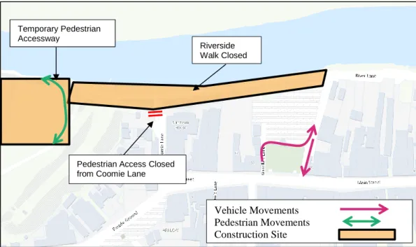
Stage A: River Walk (West)
Overview
Stage A includes the construction of the proposed sewer network and Alps SWO and stormwater storage along the south side of the Avoca River to the west of River Walk. The works are primarily along the route of the existing river side walkway and the extent of Stage A works is noted in Figure 7.8.
Figure 7.8: Proposed Sewer Network – Stage A
The primary characteristics of this phase of works include the following:
• Duration – Approximately 6 months.
• The riverside walk will be closed to all persons with the unaffected riverside only accessible from the pedestrian access over the rail line.
• Pedestrian access between the riverside walk and Coomie Lane will be closed.
• Construction and general public access will be via River Lane (West) and around Arklow Town car park.
Traffic Generation
Stage A does not include any significant diversion of traffic from the local street network and the primary impact during this stage will be associated with the physical works themselves.
The projected increase in traffic associated with Stage A is noted in Table 7.4 based on the following key assumptions:
• Limited parking will be provided for staff within the works area, with staff accessing the site from the site compounds by shared transport provided by the contractor; and
• Approximately 15 construction staff will be employed at the working areas.
Temporary Pedestrian Accessway
Pedestrian Access Closed from Coomie Lane Temporary Pedestrian
Accessway
Riverside Walk Closed
Vehicle Movements Pedestrian Movements Construction Site
Table 7.4: Traffic Generation – Stage A: River Walk (West)
Staff Deliveries Service
Daily 25 pcu 9 pcu 15 pcu
AM Peak
7 pcu 2 pcu 2 pcu
PM Peak
7 pcu 2 pcu 2 pcu
pcu = passenger car units
7.4.3.2
Stage B: River Walk (Central)
Overview
Stage B includes the construction of the proposed sewer network along the south side of the Avoca River along River Walk. The extent of Stage B works is noted in Figure 7.9.
Figure 7.9: Proposed Sewer Network – Stage B
The primary characteristics of this phase of works include the following:
• Duration – Approximately 2 months.
• Riverside Walk east of the Stage B works remains open to two-way traffic at all times.
• Any required road closures will be either carried out at night and/or managed by a stop/go system to ensure access is maintained at all times.
• There will be some loss of parking during the construction of the works with between 5-10 spaces discontinued for the duration of the works.
Riverside Walk remains Open Riverside Walk remains Open
Vehicle Movements Pedestrian Movements Construction Site
• A safe pedestrian accessway will be secured along the southside of Riverside Walk for the duration of the construction works.
• Construction access will be via Condren’s Lane Upper with traffic exiting via River Lane (West).
Traffic Generation
Stage B does not include any significant diversion of traffic from the local street network and the primary impact during this stage will be associated with the physical works themselves.
The projected increase in traffic associated with Stage B is noted in Table 7.5 based on the following key assumptions:
• Limited parking will be provided for staff within the works area, with staff accessing the site from the site compounds by shared transport; and
• Approximately 5 construction staff will be employed at the working areas.
Table 7.5: Traffic Generation – Stage B: River Walk (Central)
Staff Deliveries Service
Daily 8 pcu 9 pcu 15 pcu
AM Peak
2 pcu 2 pcu 2 pcu
PM Peak
2 pcu 2 pcu 2 pcu
pcu = passenger car units.
7.4.3.3
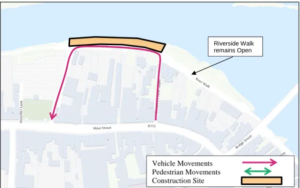
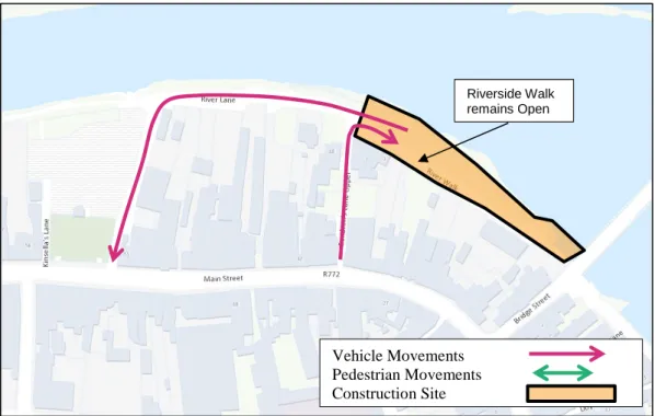
Stage C: River Walk (East)
Overview
Stage C includes the construction of the proposed sewer network along the south side of the Avoca River along River Walk. The extent of Stage C works is noted in Figure 7.10.
Figure 7.10: Proposed Sewer Network – Stage C
The primary characteristics of this phase of works include the following:
• Duration – Approximately 2 months.
• Riverside Walk east of Condren’s Lane Upper will remain accessible for all traffic during the course of the construction works.
• Any required road closures will be either carried out at night and/or managed by a stop/go system to ensure access is maintained at all times.
• There will be some loss of parking during the construction of the works with between 10-15 spaces discontinued for the duration of the works.
• A safe pedestrian accessway will be secured along the southside of Riverside Walk for the duration of the construction works.
• Construction access will be via Condren’s Lane Upper with traffic exiting via River Lane (West).
Traffic Generation
Stage C does not include any significant diversion of traffic from the local street network and the primary impact during this stage will be associated with the physical works themselves.
The projected increase in traffic associated with Stage C is noted in Table 7.6 based on the following key assumptions:
• Limited parking will be provided for staff within the works area, with staff accessing the site from the site compounds by shared transport; and
• Approximately 5 construction staff will be employed at the working areas.
Riverside Walk remains Open Riverside Walk remains Open
Vehicle Movements Pedestrian Movements Construction Site
Table 7.6: Traffic Generation – Stage C: River Walk (East)
Staff Deliveries Service
Daily 8 pcu 11 pcu 15 pcu
AM Peak
2 pcu 3 pcu 2 pcu
PM Peak
2 pcu 3 pcu 2 pcu
pcu = passenger car units.
7.4.3.4
Stage D: Arklow Bridge
Overview
Stage D includes the extension of the quay walls into the Avoca River to facilitate the construction of the proposed sewer network along the south side of the Avoca River either side of the Arklow Bridge. The extent of Stage D works is noted in Figure 7.11.
Figure 7.11: Proposed Sewer Network – Stage D
The primary characteristics of this phase of works include the following:
• Duration – Approximately 9 months.
• Riverside Walk remains open to two-way traffic at all times; Stage D works include the construction of a new quay wall and sewer under the existing Arklow Bridge.
• The underpinning of the Arklow Bridge which will require lane closures during the evening and night periods.
South Quay remains Open South Quay remains Open in one direction. Bridge Street
remains Open
South Quay remains Open in one direction. On Street Parking
Retained.
Vehicle Movements Construction Site
• The existing traffic management system will remain along South Quay with one-way traffic permitted between Doyle’s Lane and the existing Arklow Bridge and two-way for the remainder of South Quay.
• Any works to the Arklow Bridge may require the temporary closure of one of the lanes.
• On-street parking is retained along South Quay, with the exception of the parking space opposite No. 1 South Quay.
• Construction access will be via South Green.
Traffic Generation
Stage D does not include any significant diversion of traffic along South Quay with access maintained northbound along the Quay and the primary impact during this stage will be associated with the physical works themselves.
The projected increase in traffic associated with Stage D is noted in Table 7.7 based on the following key assumptions:
• Limited parking will be provided for staff within the works area, with staff accessing the site from the site compounds by shared transport provided by the contractor;
• Approximately 15 construction staff will be employed at the works area; and
• Approximately 16,400m3 of extraction and fill required to construct the proposed haul road (3 month duration).
Table 7.7: Traffic Generation – Stage D: Arklow Bridge
Staff Deliveries Service
Daily 25 pcu 46 pcu 15 pcu
AM Peak
7 pcu 6 pcu 2 pcu
PM Peak
7 pcu 6 pcu 2 pcu
pcu = passenger car units.
7.4.3.5
Stage E: South Quay/ South Green
Overview
Stage E includes the construction of two access chambers to the inceptor sewer on South Quay as well as the tunnelling of the sewer itself. The construction of the access chamber requires the complete closure of South Quay to the south of South Green. The extent of Stage E works is noted in Figure 7.12.
Figure 7.12: Proposed Sewer Network – Stage E
The primary characteristics of this phase of works include the following:
• Duration – Approximately 2 months.
• South Green closed to through traffic; all traffic on South Quay south of South Green diverted to Harbour Road.
• Pedestrian access retained along South Quay to ensure all properties retain access during the course of the works.
• Two temporary parking spaces provided to serve residential properties.
• Construction access to the access chamber construction sites will be via both South Green and Harbour Road.
Traffic Generation
Stage E does include some traffic diversion along South Quay with traffic having to divert from South Quay onto Harbour Road. The volume of traffic generated by the works themselves is expected to be relatively minimal.
The projected increase in traffic associated with Stage E is noted in Table 7.8 based on the following key assumptions:
• Limited parking will be provided for staff within the works area, with staff accessing the site from the site compounds by shared transport provided by the contractor; and
• Approximately 6 construction staff will be employed at the working areas.
South Quay traffic diverted to Harbour Road
Vehicle Movements Construction Site
Table 7.8: Traffic Generation – Stage E: South Quay/ South Green
Staff Deliveries Service
Daily 8 pcu 11 pcu 15 pcu
AM Peak
2 pcu 3 pcu 2 pcu
PM Peak
2 pcu 3 pcu 2 pcu
pcu = passenger car units.
7.4.3.6
Stage F: South Quay/ Harbour Road
Overview
Stage F includes the construction of an access chamber for the inceptor sewer on South Quay as well as the tunnelling section across the Avoca River. The
construction of the access chamber requires the complete closure of South Quay to the north of Harbour Road. The extent of Stage F works is noted in Figure 7.13.
Figure 7.13: Proposed Sewer Network – Stage F
The primary characteristics of this phase of works include the following:
• Duration – Approximately 5 months.
• South Green closed to through traffic; all traffic on South Quay south of Harbour Road diverted to Harbour Road.
South Quay traffic diverted to Harbour Road
South Quay traffic diverted to Harbour Road
South Quay traffic diverted to South Green
Vehicle Movements Construction Site
• Traffic generated north of Harbour Road along South Green diverted to South Green.
• Pedestrian access retained along South Quay to ensure all properties retain access during the course of the works.
• Any required road closures will be managed by a stop/go system to ensure access is maintained at all times.
• Construction access to and from the construction site via Harbour Road.
Traffic Generation
Stage F does include some diversion of traffic along South Quay with traffic having to divert from South Quay onto Harbour Road. The volume of traffic generated by the works themselves is expected to be relatively minimal. The projected increase in traffic associated with Stage F is noted in Table 7.9 based on the following key assumptions:
• Limited parking will be provided for staff within the works area, with staff accessing the site from the site compounds by shared transport provided by the contractor; and
• Approximately 6 construction staff will be employed at the working areas.
Table 7.9: Traffic Generation – Stage F: South Quay/ Harbour Road
Staff Deliveries Service
Daily 8 pcu 11 pcu 15 pcu
AM Peak
2 pcu 3 pcu 2 pcu
PM Peak
2 pcu 3 pcu 2 pcu
pcu = passenger car units.
7.4.3.7
Stage G: North Quay (East of Bridgewater Shopping
Centre)
Overview
Stage G includes the construction of the proposed sewer network on North Quay to the east of the entrance to the Bridgewater Shopping Centre and the
construction of an access chamber on lands to the east of the existing Ferrybank Roundabout. The construction of the access chambers requires the complete closure of North Quay to the east of the Bridgewater Shopping Centre. Access to Bridgewater Shopping Centre will be via North Quay and the Ferrybank
Roundabout while access to areas further east along North Quay will be provided via Mill Road. The extent of Stage G works is noted in Figure 7.14.
Figure 7.14: Proposed Sewer Network – Stage G
The primary characteristics of this phase of works include the following:
• Duration – Approximately 3 months.
• North Quay closed to all through traffic; all traffic diverted via the Bridgewater Shopping Centre.
• Access from the site west of the Ferrybank Roundabout will be directly from the Ferrybank Roundabout.
• Pedestrian access retained on North Quay.
• Construction traffic will need to be able to access from both sides of North Quay.
Traffic Generation
Stage G does include some diversion of traffic along North Quay with traffic east of the Bridgewater Shopping Centre having to divert from North Quay onto Mill Road. The volume of traffic generated by the works themselves is expected to be relatively minimal.
North Quay closed to all traffic
Vehicle Movements Construction Site
The projected increase in traffic associated with Stage G is noted in Table 7.10 based on the following key assumptions:
• Limited parking will be provided for staff within the works area, with staff accessing the site from the site compounds by shared transport provided by the contractor;
• Approximately 6 construction staff will be employed at the two separate working areas; and
• Both sites will be active simultaneously.
Table 7.10: Traffic Generation – Stage G: North Quay (East of Bridgewater Shopping Centre)
Staff Deliveries Service
Daily 16 pcu 22 pcu 30 pcu
AM Peak
4 pcu 6 pcu 4 pcu
PM Peak
4 pcu 6 pcu 4 pcu
pcu = passenger car units.
7.4.3.8
Stage H: North Quay (East of Ferrybank)
Overview
Stage H includes the construction of a single access chamber along North Quay between the Ferrybank Roundabout and the Bridgewater Shopping Centre. The construction of the access chamber requires the complete closure of North Quay to the south of the Ferrybank Roundabout and access to North Quay and the Bridgewater Shopping Centre will be provided via a new road from Seaview Avenue to the shopping centre and then onto North Quay. The extent of Stage H works is noted in Figure 7.15.
Figure 7.15: Proposed Sewer Network – Stage H
The primary characteristics of this phase of works include the following:
• Duration – Approximately 1 month.
• North Quay closed to all through traffic; all traffic diverted onto Seaview Avenue and Mill Road.
• Pedestrian access retained on North Quay.
• All local access maintained during the course of the construction works.
• Construction Access via the Ferrybank Roundabout and the North Quay via Mill Road and the Bridgewater Shopping Centre.
Traffic Generation
Stage H includes the diversion of traffic along North Quay with traffic west of the Bridgewater Shopping Centre having to divert from North Quay onto Seaview Avenue. The volume of traffic generated by the works themselves is expected to be relatively minimal and is presented in Table 7.11 based on the following key assumptions:
• Limited parking will be provided for staff within the works area, with staff accessing the site from the site compounds by shared transport provided by the contractor;
• Approximately 3 construction staff will be employed at the working areas.
North Quay closed to all traffic
Pedestrian access retained Pedestrian access retained
Traffic diverted through Seaview Avenue
Vehicle Movements Construction Site
Table 7.11: Traffic Generation – Stage H: North Quay (East of Ferrybank)
Staff Deliveries Service
Daily 4 pcu 11 pcu 15 pcu
AM Peak
1 pcu 3 pcu 2 pcu
PM Peak
1 pcu 3 pcu 2 pcu
pcu = passenger car units.
7.4.3.9
Stage I: North Quay (West of Ferrybank)
Overview
Stage I includes the construction of a single access chamber along North Quay between the Ferrybank Roundabout and the Bridgewater Shopping Centre. The construction of the access chamber requires the complete closure of North Quay to the south of the Ferrybank Roundabout and access to North Quay and the Bridgewater Shopping Centre will be provided via Seaview Avenue. The extent of Stage I works is noted in Figure 7.16.
Figure 7.16: Proposed Sewer Network – Stage I
The primary characteristics of this phase of works include the following:
• Duration – Approximately 1 month.
• North Quay closed to all through traffic; all traffic diverted onto Seaview Avenue and Mill Road.
North Quay closed to all traffic
Pedestrian access retained Pedestrian access retained
Traffic diverted through Seaview Avenue
Vehicle Movements Construction Site
• Pedestrian access retained on North Quay.
• All local access maintained during the course of the construction works.
• Construction access via both the Ferrybank Roundabout and the North Quay via the Bridgewater Shopping Centre.
Traffic Generation
Stage I includes the diversion of traffic along North Quay with traffic west of the Bridgewater Shopping Centre having to divert from North Quay onto Seaview Avenue. The volume of traffic generated by the works themselves is expected to be relatively minimal and is presented in Table 7.12 based on the following key assumptions:
• Limited parking will be provided for staff within the works area, with staff accessing the site from the site compounds by shared transport provided by the contractor; and
• Approximately 3 construction staff will be employed at the working areas.
Table 7.12: Traffic Generation – Stage I: North Quay (West of Ferrybank)
Staff Deliveries Service
Daily 4 pcu 11 pcu 15 pcu
AM Peak
1 pcu 3 pcu 2 pcu
PM Peak
1 pcu 3 pcu 2 pcu
pcu = passenger car units.
7.4.3.10
Stage J: Marina Village
Stage J includes the construction of access chambers and sewers on North Quay and within the Marina Village. The construction of these access chambers requires the complete closure of North Quay to the east of Marina Village and the entrance to the residential development itself. The extent of Stage J works is noted in Figure 7.17.
Figure 7.17: Proposed Sewer Network – Stage J
The primary characteristics of this phase of works include the following:
• Duration – Approximately 3 months.
• North Quay closed to all through traffic; all traffic diverted via the Bridgewater Shopping Centre and Mill Road.
• Pedestrian access retained on North Quay
• The temporary relocation of the access serving Marina Village from North Quay to Mill Road
• Temporary provision of 14 parking spaces.
• Construction access will be required from both directions along North Quay.
• No construction access will be permitted through Marina Village.
North Quay closed to all traffic
Vehicle Movements Construction Site
Traffic Generation
Stage J includes the diversion of traffic along North Quay with traffic west of the Bridgewater Shopping Centre having to divert from North Quay onto Mill Road. The volume of traffic generated by the works themselves is expected to be
relatively minimal and is presented in Table 7.13 based on the following key assumptions:
• Limited parking will be provided for staff within the works area, with staff accessing the site from the site compounds by shared transport provided by the contractor; and
• Approximately 6 construction staff will be employed at the working areas.
Table 7.13: Traffic Generation – Stage J: Marina Village
Staff Deliveries Service
Daily 8 pcu 11 pcu 15 pcu
AM Peak
2 pcu 3 pcu 2 pcu
PM Peak
2 pcu 3 pcu 2 pcu
pcu = passenger car units.
7.4.3.11
Stage K: Marina Village
Stage K includes the construction of an access chamber on North Quay to the east of Marina Village. The construction of this access chamber requires the complete closure of North Quay to the east of Marina Village. The extent of Stage K works is noted in Figure 7.18.
Figure 7.18: Proposed Sewer Network – Stage K
The primary characteristics of this phase of works include the following:
• Duration – Approximately 3 months.
• North Quay closed to all through traffic; all traffic diverted via the Bridgewater Shopping Centre and Mill Road.
• Pedestrian access retained on North Quay.
• Temporary access roads provided to serve the eastern most residential buildings within Marina Village.
Traffic Generation
Stage K includes the diversion of some traffic along North Quay with traffic west of the Bridgewater Shopping Centre having to divert from North Quay onto Mill Road. The volume of traffic generated by the works themselves is expected to be relatively minimal and is presented in Table 7.14 based on the following key assumptions:
North Quay closed to all traffic
Vehicle Movements Construction Site
• Limited parking will be provided for staff within the works area, with staff accessing the site from the site compounds by shared transport provided by the contractor; and
• Approximately 6 construction staff will be employed at the working area.
Table 7.14: Traffic Generation – Stage K: Marina Village
Staff Deliveries Service
Daily 8 pcu 11 pcu 15 pcu
AM Peak
2 pcu 3 pcu 2 pcu
PM Peak
2 pcu 3 pcu 2 pcu
pcu = passenger car units.
7.4.3.12
Stage L: Marina (North)
Overview
Stage L includes the construction of a number of access chambers along North Quay to the north of the existing Marina. The construction of these access
chambers requires the complete closure of North Quay to the north of the Marina and the construction of a temporary access road to the north of the Marina. The extent of Stage L works is noted in Figure 7.19.
Figure 7.19: Proposed Sewer Network – Stage L
The primary characteristics of this phase of works include the following:
• Duration – Approximately 4 months.
• North Quay closed to all through traffic; all traffic diverted via the Bridgewater Shopping Centre and Mill Road.
• Pedestrian access retained on North Quay.
• Temporary access road provided to serve the eastern end of North Quay.
Traffic Generation
Stage L includes the diversion of some traffic along North Quay with traffic west of the Bridgewater Shopping Centre having to divert from North Quay onto Mill Road. The volume of traffic generated by the works themselves is expected to be relatively minimal and is presented in Table 7.15 based on the following key assumptions:
• Limited parking will be provided for staff within the works area, with staff accessing the site from the site compounds by shared transport provided by the contractor; and
North Quay closed to all traffic
Temporary Road Diversion
Vehicle Movements Construction Site
• Approximately 6 construction staff will be employed at the working areas.
Table 7.15: Traffic Generation – Stage L: Marina (North)
Staff Deliveries Service
Daily 8 pcu 11 pcu 15 pcu
AM Peak
2 pcu 3 pcu 2 pcu
PM Peak
2 pcu 3 pcu 2 pcu
pcu = passenger car units.
7.4.3.13
Stage M: Marina (North)
Overview
Stage M includes the construction of an access chamber along North Quay to the northeast of the existing Marina. The construction of this access chamber (TSN8) requires the complete closure of the eastern end of North Quay and the
construction of a temporary access road to the north of the Marina. The extent of Stage M works is noted in Figure 7.19.
Figure 7.20: Proposed Sewer Network – Stage M
The primary characteristics of this phase of works include the following:
• Duration – Approximately 2 weeks.
• North Quay closed to all through traffic; all traffic diverted via the Bridgewater Shopping Centre and Mill Road.
• Pedestrian access retained on North Quay.
• Temporary access road provided to serve the eastern end of North Quay.
• Construction access will be via Mill Road.
Traffic Generation
Stage M includes the diversion of some traffic along North Quay with traffic west of the Bridgewater Shopping Centre having to divert from North Quay onto Mill Road. The volume of traffic generated by the works themselves is expected to be relatively minimal and is presented in Table 7.16 based on the following key assumptions:
North Quay closed to all traffic
Temporary Road Diversion
Vehicle Movements Construction Site
• Limited parking will be provided for staff within the works area, with staff accessing the site from the site compounds by shared transport provided by the contractor; and
• Approximately 3 construction staff will be employed at the working areas.
Table 7.16: Traffic Generation – Stage M: Marina (North)
Staff Deliveries Service
Daily 4 pcu 11 pcu 15 pcu
AM Peak
1 pcu 3 pcu 2 pcu
PM Peak
1 pcu 3 pcu 2 pcu
pcu = passenger car units.
7.5
Likely Significant Effects
The following sections presents the projected change in traffic flows on the surrounding road network based on the projected additional traffic associated with the construction works including both the WwTP and the interceptor sewer
network and associated development. In addition, separate individual assessments will be presented for each of the Stages, presenting the projected change in traffic environment due to the introduction of temporary traffic management measures.
7.5.1
Do Nothing Scenario
Under a ‘Do Nothing Scenario’ no temporary increase in traffic is expected and traffic conditions on the surrounding road network will remain as current with some queues and delays evident along Ferrybank Road and approaching Main Street and Arklow Bridge in the town.
7.5.2
Assessment of Effects during Construction
7.5.2.1
Traffic Generation
It is envisaged that the construction of the WwTP will occur at the same time as the interceptor sewer network and associated works. In addition, it is likely that one of the construction stages associated with the northern interceptor sewer will be under construction at the same time as the southern interceptor sewer. For the purpose of this assessment it has been assumed that Stage D along the South Quays and Stage G along the North Quays are carried out at the same time, along with the peak construction works envisaged for the WwTP, to provide a robust assessment of the reasonable worst case likely significant effects.
Therefore, the maximum projected increase in traffic associated with this likely construction sequence will result in the following increase in traffic flows.
Table 7.17: Projected Peak Traffic Generation – Construction Phase
Staff Deliveries Service TOTAL
Daily 401 pcu 388 pcu 145 pcu 934 pcu
AM Peak
56 pcu 50 pcu 18 pcu 124 pcu
PM Peak
56 pcu 50 pcu 18 pcu 124 pcu
pcu = passenger car units.
7.5.2.2
Traffic Distribution
It is proposed to restrict the routing of construction deliveries to limit the effects of traffic within the study area. The following restriction will be put in place for the duration of the works:
• All construction deliveries to the WwTP and the sewer network north of the Avoca River will access and egress the works area from Junction 20 on the M11 Motorway.
• All construction deliveries to the sewer network and associated works south of the Arklow Bridge will access the works area from Junction 21 on the M11 Motorway and egress via Junction 20 on the M11 Motorway.
Construction staff will not be subject to the above restrictions and the following distribution of staff traffic has been applied.
Table 7.18: Project Staff Traffic Distribution
Link Distribution
Ferrybank 45%
Abbey Street 15%
Main Street 40%
7.5.2.3
Traffic Assignment
Table 7.19 presents the projected increase in traffic associated with the construction of the proposed development taking into account the envisaged sequencing of construction stages. The projected traffic flows have been
calculated for the Year 2020 as this is the time period where construction activity is expected to be at peak.
Table 7.19: Traffic Assignment
Link 09:00-10:00 17:00 – 18:00 Daily
Ferrybank 56 pcu 56 pcu 423 pcu
North Quay 76 pcu 76 pcu 588 pcu
South Quay – One Way Section 15 pcu 15 pcu 63 pcu
South Quay – Two Way Section 15 pcu 15 pcu 63 pcu
Bridge Street 31 pcu 31 pcu 211 pcu
Arklow Bridge 35 pcu 35 pcu 251 pcu
Abbey Street 12 pcu 12 pcu 91 pcu
South Green 4 pcu 4 pcu 30 pcu
Harbour Road 12 pcu 12 pcu 91 pcu
Main Street 22 pcu 22 pcu 160 pcu
7.5.2.4
Projected Traffic Increases
The following tables (Table 7.20, Table 7.21 and Table 7.22) present the projected future traffic flows during construction both with and without the proposed
development as well as the projected percentage change in traffic flows.
Table 7.20: Projected Traffic Flows - 2020 Without Development
Link 09:00-10:00 17:00 – 18:00 Daily
Ferrybank 1237 pcu 1068 pcu 15840 pcu
North Quay 534 pcu 604 pcu 6639 pcu
South Quay – One Way
Section 131 pcu 112 pcu 1496 pcu
South Quay – Two Way
Section 84 pcu 87 pcu 1184 pcu
Bridge Street 673 pcu 745 pcu 8765 pcu
Arklow Bridge 1114 pcu 911 pcu 14382 pcu
Abbey Street 298 pcu 353 pcu 4414 pcu
South Green 218 pcu 132 pcu 2644 pcu
Harbour Road 63 pcu 70 pcu 816 pcu
Table 7.21: Projected Traffic Flows - 2020 With Development
Link 09:00-10:00 17:00 – 18:00 Daily
Ferrybank 1181 pcu 1011 pcu 15417 pcu
North Quay 458 pcu 528 pcu 6050 pcu
South Quay – One Way Section 116 pcu 97 pcu 1433 pcu
South Quay – Two Way Section 69 pcu 73 pcu 1121 pcu
Bridge Street 642 pcu 714 pcu 8545 pcu
Arklow Bridge 1079 pcu 876 pcu 14131 pcu
Abbey Street 286 pcu 340 pcu 4324 pcu
South Green 214 pcu 128 pcu 2614 pcu
Harbour Road 50 pcu 58 pcu 726 pcu
Main Street 829 pcu 817 pcu 12225 pcu
Table 7.22: Projected Percentage Change in Traffic Flows - 2020
Link 09:00-10:00 17:00 – 18:00 Daily
Ferrybank 4.8% 5.6% 2.7%
North Quay 16.6% 14.4% 9.7%
South Quay – One Way Section 13.1% 14.6% 4.4%
South Quay – Two Way Section 22.0% 19.4% 5.6%
Bridge Street 4.8% 4.3% 2.6%
Arklow Bridge 3.2% 4.0% 1.8%
Abbey Street 4.3% 3.6% 2.1%
South Green 2.0% 3.3% 1.2%
Harbour Road 24.7% 21.5% 12.5%
Main Street 2.7% 2.7% 1.3%
From the above, it can be seen that the construction of the proposed development is expected to increase traffic flows on the wider road network (i.e. Ferrybank, Abbey Street, Arklow Bridge) by less than 5% during the peak hour periods, and by less than 3% on an all day basis. The two quays (North Quay and South Quay) where the majority of the works are expected to take place are expected to have increases of approximately 15% -20% during the peak hour periods, and between 5% and 10% on an all day basis.
Based on the above it can be concluded that the proposed construction works at a wider network level will have a slight effect on traffic conditions in Arklow, as traffic increases on the primary road/street network (i.e. Ferrybank, Arklow Bridge and Main Street) are all 5% or less during the peak hour periods. However, at the individual construction sites the effect will be more significant and the following sections describe the likely significant effects of these individual construction stages.
7.5.2.5
Likely Significant Effects (Per Stage)
Stage A: River Walk (West)
Stage A does not result in any diversion in traffic flows and the potential increase in traffic along River Walk and its approach streets (Condren’s Lane Upper and River Lane (West)) will be low and the likely significant effects on traffic flows will be slight.
Stage B: River Walk (Central)
Stage B does not result in any diversion in traffic flows and the potential increase in traffic along River Walk and its approach streets will be low and the likely significant effects on traffic flows will be slight and primarily confined to River Walk where some temporary traffic management and loss of on-street parking will be required.
Stage C: River Walk (East)
Stage C does not result in any diversion in traffic flows and the potential increase in traffic along River Walk and its approach streets (Condren’s Lane Upper and River Lane (West)) will be low and the likely significant effects on traffic flows will be moderate and primarily confined to River Walk where temporary traffic management and loss of on-street parking will be required.
Stage D: Arklow Bridge
Stage D includes only a limited diversion of traffic where southeast bound traffic on South Quay will have to exit the quay via Bridge Street. The projected increase in traffic is expected to have a moderate effect on the operation of South Quay where temporary traffic management measures will potentially restrict the free movement of traffic along the Quay.
Stage D also includes the underpinning of the Arklow Bridge which will require lane closures over the bridge with traffic flow operating on a shuttle basis. The required traffic management measures have the potential to result in significant traffic congestion and to manage the likely significant effects. The following measures are proposed:
• No scheduled lane closures should commence before 21:00 and all lane closures should be lifted by 07:00 in the morning.
• The length of lane closure and the required working area needs to be kept as small as possible to reduce the length of the shuttle system.
Stage E: South Quay/ South Green
Stage E includes a limited diversion of traffic where South Quay traffic will need to use Harbour Road to access the wider street network. This will result in the projected change in traffic flows on Harbour Road and South Green as outlined in Table 7.23.
Table 7.23: Projected Stage E Diversion Traffic Flows
Link 09:00-10:00 17:00 – 18:00 Daily
Without With Without With Without With
South Green 214 pcu 283 pcu 128 pcu 201 pcu 2614 pcu 3,735 pcu
Harbour Road 50 pcu 119 pcu 58 pcu 131 pcu 726 pcu 1,847 pcu
The projected increase in traffic is expected to have a moderate effect on the traffic operations along South Quay, South Green and Harbour Road, particularly where traffic has to use longer routes due to the implementation of the temporary traffic diversions. Both South Green and Harbour Road will see an expected increase in traffic flows however these streets currently experience very low traffic flows and have sufficient capacity to accommodate the projected increase in traffic.
Stage F: South Quay/ Harbour Road
Stage F also includes for the diversion of traffic from South Quay to both Harbour Road and South Green to access the wider street network. This will result in a similar projected change in traffic flows on Harbour Road and South Green as noted in Table 7.23.
This projected increase in traffic is expected to have a moderate effect on traffic operations, particularly where traffic has to use longer routes due to the
implementation of the temporary traffic diversions. In addition, both South Green and Harbour Road will see an increase in traffic flows.
Stage G: North Quay (East of Bridgewater Shopping Centre)
Stage G includes for the diversion of traffic from North Quay (East of
Bridgewater Shopping Centre) to Mill Road. This diversion is expected to have a moderate effect on traffic operations, as traffic flows on this section of North Quay are relatively light with daily traffic flows noted at approximately 1,200 passenger car units (pcu) per day.
The primary effects associated with this stage of the works will be longer traffic journeys, traffic on North Quay will have to take, to access the wider street network, however no additional traffic congestion is expected during this stage due to the low level of traffic on Mill Road.
Stage H: North Quay (East of Ferrybank)
Stage H includes for a major diversion of traffic from North Quay (East of Ferrybank) to Seaview Avenue. The closure of North Quay will result in
approximately 6,000 daily trips rerouting through Seaview Avenue and accessing the shopping centre and North Quay via a new road link.
This diversion of traffic is expected to be a significant negative effect on traffic operations, particularly at the junction of Ferrybank Road/ Seaview Avenue with the potential for long queues forming at the junction. To manage these potential likely significant effects and traffic restrictions, the following measures are suggested:
• The works should be carried out during a quiet period of the year, possibly late summer however impacts on tourist traffic will also need to be
considered.
• The works should be carried out utilising a longer working day 16 - 24 hour basis, however the impact on adjacent residents would need to be considered to reduce the time North Quay needs to remain closed.
• The junction of Ferrybank/ Seaview Avenue would need to be manned during busy periods to ensure the junction operates efficiently and safely.
• Parking in and around the junction of Ferrybank and Seaview Avenue needs to managed and controlled.
Stage I: North Quay (West of Bridgewater Ferrybank)
Stage I also includes the diversion of traffic from North Quay (East of Ferrybank) to Seaview Avenue as noted under Stage H. The closure of North Quay is
expected to have a significant effect on traffic operations, particularly at the junction of Ferrybank Road/ Seaview Avenue with the potential for long queues forming at the junction. The potential traffic management measures to mitigate this increase in traffic are as presented under Stage H.
Stage J: Marina Village
Stage J includes for the diversion of traffic from North Quay (East of Bridgewater Shopping Centre) to Mill Road. In addition, Marina Village will need to be
temporarily accessed via Mill Road. This diversion is expected to have a moderate effect on traffic operations, as traffic flows on this section of North Quay are relatively light with daily traffic flows noted at approximately 1,200 passenger car units (pcu) per day.
The likely significant effects associated with this stage of the works will be longer journeys for traffic on North Quay and residents accessing Marina Village,
however no additional traffic congestion is expected during this stage of the works due to the current low level of traffic using Mill Road.
Stage K: Marina Village
Stage K is expected to have very similar effects to that noted under Stage J,
however the temporary access to Marina Village from Mill Road will no longer be required. The diversion of traffic is expected to have a slight effect on traffic operations due to longer distances travelled but no additional traffic congestion is expected during this stage of the works due to the current low level of traffic using Mill Road.
Stage L: Marina (North)
Stage L is expected to have a slight effect on traffic operations due to longer distances travelled but no additional traffic congestion is expected during this stage of the works.
Stage M: Marina (North)
Stage M is expected to have a slight effect on traffic operations as traffic accessing the WwTP site will need to use Mill Road and the new temporary construction road. However, due to the prevailing traffic conditions in the area no additional traffic congestion is expected during this stage of the works.
7.5.2.6
Cumulative
The construction works associated with the proposed Arklow Flood Relief Scheme have the potential to impact on the construction of the proposed development. There is the potential that should the projects be carried out simultaneously, co-ordinated traffic management plans will need to be prepared and agreed with Wicklow County Council.
As the proposed Arklow Flood Relief Scheme is still (at the time of writing) in its early design stage it is not possible to carry out a detailed combined assessment on traffic and transport. However the EIAR for the proposed Arklow Flood Relief Scheme will need to address the cumulative effects of it with the proposed development in due course.
At a wider level, the construction of both projects simultaneously will result in greater traffic flows, including Heavy Goods Vehicles on all the streets within Arklow and there is likely to be greater effects along both the North and South Quays where the works themselves will be concentrated.
7.5.3
Assessment of Effects during Operation
During the operation of the proposed development the projected increases in traffic flows will be very small, with between 10- 20 additional trips expected per day. This projected increase in traffic will have an imperceptible effect on
prevailing traffic conditions.
7.6
Mitigation Measures and Monitoring
7.6.1
Mitigation
7.6.1.1
Mitigation During Construction
Construction Traffic Management Plan
The appointed contractor for the proposed development will prepare a detailed Construction Traffic Management Plan covering all stages of construction. This plan will need to take into account other potential construction works in the area including the proposed Arklow Flood Relief Scheme.
The Construction Traffic Management Plan will demonstrate how pedestrians, cyclists and motorised vehicles can pass through the working areas safely and that measures are in place which ensure traffic operates in as an efficient manner possible.
Consultation Plan
The Construction Traffic Management Plan will include a detailed Consultation Plan to deal with third party queries from both residents and retail/commercial operators. The Construction Traffic Management Plan will require agreement with both Wicklow County Council and An Garda Síochána.
The contractor will appoint a single point of contact to facilitate the
communication of the various traffic management plans and the preparation of a project specific website to aid communications would also be beneficial.
Mobility Management Plan
As part of the Construction Traffic Management Plan a Mobility Management Plan will be prepared to ensure access to the site by sustainable travel modes is encouraged. The following measures will need to be considered within the Mobility Management Plan:
• The provision of showers/ changing rooms for construction staff;
• The provision of cycle parking for staff; and
• The promotion of car sharing among staff, including van pooling to travel between the different working areas.
Individual Traffic Management Plans
For Stage H and Stage I the following individual traffic management measures should be considered as part of the Construction Traffic Management Plan:
• The works should be carried out during a quiet period of the year, possibly late summer however impacts on tourist traffic will also need to be
considered.
• The works should be carried out utilising a longer working day 16-24 hour basis, however the impact on adjacent residents would need to be considered to reduce the time North Quay needs to remain closed.
• The junction would need to be manned during busy periods to ensure the junction operates efficiently and safely.
• Parking in and around the junction of Ferrybank and Seaview Avenue needs to managed and controlled by appropriately trained personnel.
For any works to Arklow Bridge that require lane closures the following measures are suggested:
• No scheduled lane closures should commence before 21:00 and all lane closures should be lifted by 07:00 in the morning.
• The length of lane closure and the required working area needs to be kept as small as possible to reduce the length of the shuttle system.