Locating Mechanized Parking in Qom with Sustainable Development
Approach (A study on the city of Qom)
Saeid Sadeghi Darvazeh*
Faculty of Management & Accounting, Allameh Tabataba'i University, Tehran, Iran Ahmadreza Ghasemi
Department of Industrial Management, Faculty of Management and Accounting, Pardise Farabi University of Tehran, Qom, Iran
Neda Rasouli Tilenoei
Faculty of Management and Accounting, Pardise Farabi University of Tehran, Qom, Iran Abbas Shoul
Department of Industrial Management, Faculty of Administrative Sciences and Economy,Vali-e-Asr University of Rafsanjan, Rafsanjan, Iran
Received: 2017/06/28 Accepted: 2017/10/06
Abstract: Population growth and urbanization, increase in number of private vehicles,
low-width’s streets and lack of marginal parking spaces, especially in central parts of cities, have brought numerous problems for big and populated cities. Locating mechanized parking lots, which with occupying less area have a high parking capacity, is of the necessities of urban and traffic planning in large cities. The present study aims to identify, to weight and to prioritize effective criteria in locating of mechanized parking with sustainable development approach, and ultimately to prioritize potential sites for the construction of mechanized parking lots in central part of Qom. Therefore, first with regard to principles and components of sustainable development and applicable planning of urban land and transport and traffic planning and also with regard to characteristics of Qom city, three criteria and 16 sub criteria to locate mechanized parking lots have been chosen. The method used in this research for weighting and prioritization of locating criteria and sub criteria is Analytic Network Process (ANP) and fuzzy PROMETHEE. Therefore, after gathering the required data from the paired comparison questionnaire and calculate the total weight of the criteria, priority was given as followed: “environmental” criterion with weight of 0.429 in top priority, “economic” criterion with weight of 0.347 in second priority and “social” criteria with weight of 0.251 was located in third priority. Moreover, the result of ranking potential sites to construct mechanized parking using fuzzy PROMETHEE were identifies as follow: location in Keivanfar street is the first place, location in Sedaqhat alley in the second place and location in ice making factory in the fourth place.
Keywords: Locating, Mechanized Parking, Sustainable Development Approach, ANP,
PROMETHEE
JEL Classification: R11, R41, R42, R53, Q01
* Corresponding Author: [email protected]
To cite this document: Sadeghi Darvazeh, S., Ghasemi, A., Rasouli Tilenoei, N., & Shoul, A. (2018). Locating Mechanized Parking in Qom with Sustainable Development Approach (A study on the city of
Qom). Urban Economics and Management, 6(1(21)), 115-130 www.iueam.ir
Indexed in: ISC, EconLit, Econbiz, SID, RICeST, Magiran, Civilica, Google Scholar, Noormags, Ensani. ISSN: 2345-2870
1- Introduction
Today, almost every family in the middle class has a personal car, and this issue has caused numerous problems for both residents and travelers as a result of the massive increase in urbanization and, consequently, the increase in vehicles. If this trend continues, in the not too distant future, the lack of parking space will be a major problem for big cities. Therefore, this has focused on the attention of many officials in thinking about the solution to this problem. One of the latest and easiest technologies used to fix this problem is the use of mechanized parking. Mechanized parking, by replacing the vertical space in place of horizontal space, has played a significant role in optimizing the parking space, as well as reducing the time and fuel consumption in order to find the free space in the parking lot for the park and the establishment of cars (Mahajan & Agrawal, 2017).
Locating, using a sustainable development approach, is one of the important approaches to locate parking lots. The sustainable development approach, taking into account the three economic, social and environmental components of locating, is one of the key factors in regional planning (Puente et al., 2007). On the other hand, the financial savings due to proper location, as well as dues due to improper parking and its adverse social, economic and environmental impacts have attracted the attention of many researchers (Takayama & Kuwahara, 2016). According to Fosgerau & De Palma (2013), the cost of parking a car in the proper way is much less than the material costs of fuel supply and the neurological and environmental effects of traffic on the busy streets of cities.
Choosing the right place to build a parking lot, in a number of ways, enhances planning for sustainable development: the first is to prevent the loss of energy and reduce pollution that will result in environmental sustainability. The second is the importance of empowering statesmen and policymakers to human and society, increasing social solidarity and paying attention to cultural identity, which leads to social sustainability. The last point is that economic sustainability can be achieved with the cost of spending in the right place and avoiding unnecessary costs and duplication. In addition to ideas for the development of public transportation infrastructure such as bus, metro etc., in order to remove traffic jams, in recent years, urban engineers have proposed the construction of mechanized parking lots that are welcomed very much. In general, the use of mechanized parking has many advantages, including the use of optimal and minimum space for park cars, the possibility of using more heights and basement space in the parking lot, increasing the safety level of passengers and occupants of cars and the reducing the possibility of crash of cars.
The holy city of Qom, as the second-largest religious city in Iran, attracts many travelers every year, hence the need for suitable parking places for facilitating the passage and avoiding marginal parks has been more important. Therefore, the first the purpose of this study is to identify and priority of the criteria involved in locating automated parking lots in line with the sustainable development approach, and then ranking each of the potential locations for the construction of automated parking in Qom. In fact, in this study, we will answer the following research questions:
1. What are the criteria and sub-criteria of locating automated parking lots in Qom in line with a sustainable development approach?
2. What is the significance of each criteria and sub-criteria?
3. What is the priority of each potential location for constructing an automated parking lot according to sustainable development criteria?
We will review the research literature on location and metrics affecting it in section 2. In section 3, the research methodology, statistical population and sample size, and data collection are presented. In Section 4, we will analyze data by using two techniques ANP and Fuzzy PROMETHEE. Finally, results and findings as well as future works are provided in section 5.
2- Literature Review
Due to the increasing traffic problems of cities and consequently decrease in satisfaction of city residents, various studies have been done by foreign and domestic researchers for organizing and accurate spatial planning in urban transportation, especially the parking use via geographic information systems and operational research techniques, which are as follows:
a) Foreign Researches
Wang & Yuan (2013) investigated urban parking management and parking planning policy in street in order to solve the problem of access to parking in a Chinese city.
In a study in Seattle, Utusan et al, (2013) determined the optimal size of parking to reach the desired level of parking space occupancy in each building block of each region.
Jelokhani- Niaraki & Malczewski (2015) in a research entitled
“Multi-functional Support System to choose the Location of Parking”, ranked the proposed locations for parking in Tehran by using a hybrid and integrated approach of GIS and MCDA.
Rosselli et al., (2016) in a study entitled “An integrated approach of AHP and GIS for locating Malaysian Parking lots”, used the AHP technique to weight the parking location criteria in the city of Alexandria in Malaysia, and then ranked potential locations for construction of parking by using the GIS location technique.
b) Iranian Researches
Motakan et al. (2007) determined the optimum locations for constructing parking lots in District One of Tehran (Tajrish region) using the AHP weighing technique and the GIS tool by considering criteria such as distance from travel attraction centers, distance from trails, the cost of land ownership, suitable use for parking construction and imposing restrictions such as distance from faults and inappropriate uses.
Karimi et al., (2007) used AHP method and GIS tool to locate urban facilities with emphasis on location of vertical parking lots. Indicators used in this study include the quality of construction, accessibility, distance from travel attraction centers and property values. The results of weighting the indices with the AHP technique indicated that the indicator distance from the travel attraction centers with a weight of 0.547 has the first level of importance. After that, the accessibility with a weight of 0.240 was indicated as the second most important index.
Zamani (2007) tried to locate vertical parking lot in Qom using fuzzy ANP technique and GIS tool. The results of this study showed that the criteria of distance from travel attraction centers,
accessibility, and features of the fragment with the weight of 0.402, 0.393 and 0.220 placed in the first, second and third level of importance, respectively.
In a research study, Talebi (2010) located floor parking in Tehran Municipality district seven. In this study, the index and fuzzy overlapping method were used to weigh the effective parameters on the location of parking lots. Finally, tried to rank the potential locations for construction vertical parking lots using GIS software.
Abbasi Kalkani & Seyed Hosseini (2011) investigated the location of public parking lots in District 3 of Karaj metropolis using AHP and GIS methods. First, tried to weigh the effective criteria in locating using the AHP technique including distance from travel attraction centers (commercial, administrative, educational, cultural, sporting, religious, sanitary-and-health), distance from urban roads and the use of existing land (existing parking lots, wasteland, unfinished buildings) and then ranked the suitable places for construction of parking lots using GIS software.
In another study, Roustai et al., (2011) studied the location of local parking lots in District 3 and 4 Tabriz. In this study some criteria such as population, building density, walking distance to parking, access based on street width, parking, number of vehicles, parking demand, land prices, user compatibility and parking capacity were introduced as the most important criteria involved in local parking location.
Ghanbari & Ghazi Askar Naini (2010) in the study entitled “Evaluation of different location methods in managing public parking construction in the commercial center of Isfahan using GIS” evaluated different types of weighting methods using
fuzzy and deterministic approaches and selected the Analytic Hierarchy Process (AHP) as the best and most accurate method of weighting to location criteria. In this study, the involved indicators for the location of public parking lots included distance from travel attraction centers, proximity to streets, property, population, the suitable use for construction of parking lots and inappropriate centers for parking.
Rashidi Fard et al., (2011) investigated location of parking lot in Dehdasht city based on some metrics such as population density, walking distance, land prices, parking demand, the number of cars, density of buildings, accessibility, parking capacity by using Network Analysis Model and GIS.
Soleimani et al., (2014) investigated the location of parking lots based on criteria of distance from travel attraction centers, distance from access routes and paths, land prices, the proper use for establishing parking lots in Mianeh cities using the fuzzy method in GIS environment.
Yaghfuri, Fotohi & Masjedi (2016), in a study entitled “Distribution of spatial-location public parking lots and their optimal locations (Case Study: District 2 and 8 Shiraz)” determined the appropriate areas for constructing parking lots in District 2 and 8 of Shiraz using the analysis of Geographic Information System, for example, Index Overlay Mode.
3- Theoretical Background
Choosing the right location for deploying a use is a search about finding a position that can be fitted to the specific needs of the use. The requirements for deploying different uses at the appropriate location are either the selection criteria or location criteria. The process of positioning
and choosing the location of uses according to the desired criteria is called locating. In such a process, the first step after identifying the location criteria is the collecting data and information. In fact, location is a part of urban land-use planning which chooses appropriate and optimal locations for a particular use in a complex texture of city by considering indices and criteria and using analytical methods. In recent decades, immigration and the increased urbanization and consequently the increase in motor vehicles have caused the metropolitan authorities and planners face many problems in reducing marginal parking. Identification of criteria and the use of appropriate methods and tools in locating parking lots can greatly solve the problems caused by marginal parks (Niaraki & Malczewski, 2015).
Exact evaluation of the future needs of parking lots is difficult that is due to the influence of various factors in this case, such as increasing personal machines, increasing population, developing commercial areas and increasing purchasing power that increases population movement (François, 2013).
Previous research studies show that various researchers consider different approaches and metrics in their research depending on the type of parking such as public, vertical, automated, etc., and the characteristics of the study area. Sustainable Development is one of the approaches has been considered by many researchers recently.
Urban transportation difficulties are one of the main problems in sustainable urban development. The discussion about the role of environmentally friendly practices and social responsibility in various areas of urban development is a topic that has attracted much attention in recent years. This issue will be more important for
managers who want to invest profoundly in environmental and social practices because today concerns about the negative social and environmental impacts of an increase in the number of vehicles and heavy traffic are increasing and these negative impacts will also be detrimental to economic issues (Wan Ahmad et al., 2016). An urban planner should consider all aspects and issues related to the city, especially citizens, in accordance with the principles of urban land-use planning to accurately locate any kind of urban land use and selects location metrics based on six principles of compatibility, comfort, efficiency, utility, health and safety (Saeidnia, 2004). It is obvious that all social, economic and environmental concerns should be considered in order to achieve sustainable development. Specific features of the study area, as the basis of the work, can change the criteria or make them preferable. Therefore, it is necessary to take into account the specific conditions and the significant role of a city for determining the criteria related to locating a use or service center in that city. Therefore, some criteria are applicable to all cities and others are dependent on the city under study. The sustainable development approach is a procedure that provides the high ability of extensibility and compatibility to the specific needs of the use in each region with any attribute by considering simultaneously the three social, economic and environmental components. Therefore, in this study, the locating of automated parking places in Qom (as the second Iranian religious city after Mashhad) has been addressed in line with sustainable development approach. Thus according to the specific characteristics of automated parking lots, following the principles and considering urban traffic and transportation
planning is necessary. On the other hand, Qom has unique features that attract pilgrims as well as many students from different parts of Iran and the world annually, and the necessary precautions in this regard should be considered.
According to the mentioned above, many researchers have weighted the effective criteria in locating the parking lots based on various criteria and approaches and using multiple-criteria decision-making techniques and determined the proper positions for construction different types of parking lots, such as flat, vertical, etc. by adopting the GIS method. In this research, after the extensive review in literature and research background, the criteria involved in locating automated parking lots were identified and extracted; then by considering the experts' view, the identified criteria in the previous step were adapted and customized based on the specific characteristics of the city of Qom. Table 1 presents the effective criteria and sub-criteria in locating automated parking lots used in this study which are extracted, adapted and customized based on the results of previous research
as well as surveys and interviews with experts and specialists in urban planning, transportation, and traffic of Qom municipality. As seen, 16 effective sub-criteria in locating automated parking lots in Qom are categorized into three components of sustainable development, including social, economic and environmental. The distinguishes between the present research and previous research can be summarized into two categories thematic innovation and methodological innovation.
The present study has a thematic innovation because locates the automated parking lots in Qom by using the sustainable development approach for the first time. In other words, if we consider all aspects of our actions in the interaction between the three components of sustainable development, the result will be the locating of automated parking lots with a sustainable development approach. Furthermore, in the present study, a multiple-criteria decision-making technique called PROMETHEE has been used for ranking the potential locations for constructing parking lots in Qom for the first time which has a methodological innovation.
Table1. The effective criteria and sub-criteria in locating automated parking lots.
Source Sub-criteria
criteria
Ghazi Askar Naini (2004) Zamani (2009)
Ebadi (2007) Ghazi Askar ((2007) Motakan (2007)
Gozar Rah Consultant Engineering (2008)
Farnahad Consultant Engineers (2008) Tehran Urban Planning & Research Center (2014)
Yaghfuri, Fotohi and Masjedi (2016) Roy Wang (2013)
Daddy Baldur Utusan (2013) Niaraki & Malczewski (2015) Rosselli et al. (2016)
Property value Economic Land use
Features of the building Population
Social
Proximity to business centers Proximity to office centers Proximity to religious centers
Proximity to Religious Science Centers Proximity to the hospital
Proximity to the terminal-station
Proximity to recreational- sports centers and cinema
Main arteries Air pollution Environmental Noise Pollution
Incidents and Accidents Climate change
4- Research Method
The present study is applied in terms of purpose, and it is descriptive-survey in terms of data collection. First, the library method has been used to formulate theoretical foundations. Then, the descriptive-survey method was used to identify the scope of the study and paired-comparison data collection. The questionnaire of the present study is a paired-comparison questionnaire in a table format in which criteria are compared with each other. In terms of thematic, it is placed in the area of location studies especially in the field of locating automated parking lots with a sustainable development approach. In this study, the required data were collected in two stages. First, the effective factors and metrics in locating automated parking lots were extracted via a sustainable development approach by a detailed and comprehensive review of the literature and research backgrounds. Then, a survey was carried out in a group of managers, experts, and specialists of Qom municipality in order to adapt and specify the extracted criteria. The identified criteria in the previous step were weighted using the fuzzy ANP technique. Finally, the potential locations for construction of automated parking lots were ranked using the fuzzy PROMETHEE technique. In the comprehensive studies, transportation and traffic of Qom city, urban and suburban areas of Qom were considered as the study area. Due to the existing uses of some urban areas, there is no parking problem and its status is desirable, thus in order to study the location of automated parking in Qom, the center of this city was selected. After interviewing with the experts and municipal authorities, four potential locations for the construction of automated parking lots were identified. As seen in
Figure 1, all potential locations for the construction of parking lot are located Emam Khomeini street (between Emam Khomeini Square and Saeedi square). In this figure, each of potential locations is indicated by the symbols P1 to P4. P1 is the location of parking lot 1 located at the intersection of Imam Khomeini street and Keivanfar Street; P2 the location of parking lot 2 located on Imam Khomeini Street, Kianfar Avenue, next to Sedaghat Manesh Alley; P3 is the location of parking lot 3 located on Imam Khomeini Street above Saeedi Square, 8 meters from Amirkabir, Alley 45, and finally P4 the location of 4th parking lot located on Imam Khomeini Street, Saeedi Square, Niroo Havayi Boulevard.
The statistical population of this study includes all managers, experts, and specialists in urban planning, transportation, and urban traffic who work in Qom municipality and have knowledge about locating automated parking lots, sustainable development components, and also sufficient information about transportation and traffic problems of this city. After consultation with the mayor of Qom, the size of the population was estimated at 2. Some metrics such as education, experience and, most importantly, the sharing of knowledge and experience in the field of locating and the components of sustainable development were the basis of selecting the experts who completed the paired-comparison questionnaires. Both experts have higher education than Master’s degree, more than 7-year experience, besides experience in the area of locating parking lots as well as the components of sustainable development. It should be noted that there is no specific formula for determining the statistical sample size in the multiple-criteria decision-making methods, but
because of the small size of the target community, it is attempting to census a team of experts. Thus, the sampling strategy is targeted or judgmental (Ghasemi et al., 2015). Therefore, the opinion of both experts was used in order to complete the paired-comparison questionnaire. In order to collect data, 5-alternative paired comparison questionnaires were used. In the expert questionnaire, which is based on a paired comparison of all the elements, the probability of not considering a variable
is zero. Therefore, all criteria in this measure are considered and the designer cannot orientate in the design of the questions. Hence, the paired comparison questionnaires are intrinsically justifiable (Ghodsipour, 2002). The compatibility rate of Gogus & Boucher (1997) were used to verify the durability of the comparisons. After the revision and recompletion of some incompatible matrices, the incompatibility rate of all comparisons less than 0.1 was reported.
Fig1. Potential locations for the construction of automated parking lot in Qom
As previously mentioned, in the present study, two ANP and Fuzzy PROMETHEE techniques have been used to analyze the data. The ANP technique is one of the most widely used techniques in weighting and ranking the criteria proposed by Thomas L. Saaty in 1999. In this study, we used ANP technique in fuzzy conditions to weigh the criteria involved
in locating automated parking lots. The PROMETHEE technique was introduced by two Belgian professors, Jean-Pierre Brans and Bertrand Mareschal, in the 1980s. After determining the weight of the location criteria using the fuzzy ANP technique, it is necessary to rank the potential locations for construction parking lots based on the criteria. For this
purpose, the PROMETHEE technique was used in this study.
5- Results
Determination the Weights of Indicators Using the FANP Technique
The first step in the ANP technique is related to drawing the network and determining the relationships between the criteria. To do so, in this study a survey of municipal experts was carried out. According to the expert's view, all three components of sustainable development (economic, social and environmental) have a mutual impact on each other, which was considered in the network drawing. Then the relationship between the research criteria which is shown in Figure 2, the final weights of the criteria and sub-criteria for locating the automated parking lots of Qom are calculated using the fuzzy ANP technique and presented in Tables 2 and 3, respectively. Such that
each research indicators and sub-indicators were compared to each other in the form of paired comparison tables and by each of the experts. Then, the final weight of each of the indicators and sub-indicators involved in locating the parking lots were calculated based on the experts' average views. As tables suggests, among the main criteria of research (the three components of sustainable development), the environmental component with the weight of 0.429 has the first level of importance. After that, the economic and social components with weights 0.347 and 0.251 placed in the second and third ranks, respectively. Among the criteria, the accidents and accidents sub-criterion from the ecological category was considered as the most important sub-criterion with a weight of 0.306. Figure 3 shows the final weights of the research criteria in the form of a bar chart.
Environmental factors (D3) Air pollution (C13)
Noise Pollution (C14)
Incidents and Accidents (C15) Climate change (C16)
Economic factors (D1) Property value (C1) Land use (C2)
Features of the building (C3)
Social factors (D2) Population (C4)
Proximity to business centers (C5) Proximity to office centers (C6) Proximity to religious centers (C7)
Proximity to Religious Science Centers (C8) Proximity to the hospital (C9)
Proximity to the terminal-station (C10) Proximity to recreational- sports centers and cinema (C11)
Main arteries (C12)
Fig2. The structure of ANP model
Table2. Final weights of research’s main criteria
Crisp weight Fuzzy weight
Criteria
0.347 (0.179,0.339,0.543) Economic
0.251 (0.136,0.237,0.422) Social
0.429 (0.229,0.423,0.654) Environmental
Table3. Final weights of research’s sub-criteria
Crisp weight Fuzzy weight
Sub-criteria
0.078 (0.030,0.075,0.138) Property value
0.046 (0.015,0.039,0.106) Land use
0.156 (0.061,0.150,0.277) Features of the building
0.081 (0.023,0.072,0.178) Population
0.022 (0.006,0.019,0.049) Proximity to business centers
0.021 (0.006,0.018,0.049) Proximity to office centers
0.031 (0.008,0.027,0.073) Proximity to religious centers
0.031 (0.008,0.026,0.073) Proximity to Religious Science Centers
0.048 (0.013,0.041,0.111) Proximity to the hospital
0.044 (0.013,0.037,0.101) Proximity to the terminal-station
0.044 (0.013,0.037,0.101) Proximity to recreational centers
0.042 (0.012,0.035,0.099) Proximity to main arteries
0.055 (0.020,0.052,0.100) Air pollution
0.026 (0.009,0.022,0.062) Noise Pollution
0.306 (0.127,0.297,0.520) Incidents and Accidents
0.055 (0.020,0.052,0.100) Climate change
Fig3. The final weights of research criteria
After weighing the effective criteria in locating automated parking lots in Qom with a sustainable development approach, it is time to rank potential
locations for construction parking lots. First, a questionnaire was designed for paired-comparisons of potential locations for construction of parking lots on each of
0.00 0.05 0.10 0.15 0.20 0.25 0.30 0.35
Crisp weight
the sub-criteria and distributed among a group of experts. A paired-comparison of alternatives was performed by experts using linguistic variables. Then the fuzzy equivalent of linguistic variables, alternatives, and fuzzy weight of alternatives were calculated. After that, the crisp weight of each alternative was calculated using the arithmetic mean, and the PROMETHEE decision matrix was created based on the d-fuzzy weight of the alternatives and entered into the software. In this study, PROMETHEE GAIA software was used to evaluate and rank the alternatives. This software can analyze and rank alternatives using PROMETHEE I and PROMETHEE II. Figure 4 shows the PROMETHEE I output. In Figure 4, the left column illustrates
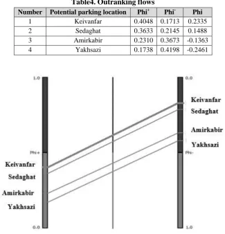
the rank of alternatives based on Phi+, which are potential locations for construction of automated parking lots. As seen, the potential location on Keivanfar Street with the highest Phi+ has the first rank. The priority of the alternatives is as follows:
Keivanfar>Sedaghat>Amirkabir>Yakhsazi The right column also shows the rank of alternatives based on the Phi-. Ranking the alternatives based on the Phi- show similar results as follows:
Keivanfar>Sedaghat>Amirkabir>Yakhsazi Table 4 shows the results of ranking based on the two parameters Phi+ and Phi -. According to the values of Phi+ and Phi-, the alternatives can be ranked with full certainty.
Table4. Outranking flows
Phi Phi
-Phi+ Potential parking location Number
0.2335 0.1713
0.4048 Keivanfar
1
0.1488 0.2145
0.3633 Sedaghat
2
-0.1363 0.3673
0.2310 Amirkabir
3
-0.2461 0.4198
0.1738 Yakhsazi
4
Fig4. The output of software- Partial ranking in PROMETHEE I
Ranking alternatives based on the positive or negative flow index in PROMETHEE I is carried out separately. As shown in Figure 4, the results of PROMETHEE I based on each of the Phi+ and Phi- indicators produced the same priorities, which indicate the high reliability of the ranking results. Based on the results of PROMETHEE I, the locations of Keivanfar, Sedaghat, Amirkabir, and Yakhsazi are prioritized as priority level 1 to 4, respectively. In the PROMETHEE I method, the outranking net flow should be calculated, which indicate the strength of each alternative respect to others, because in some cases, the ranking of alternatives has problems that arise from the lack of complete agreement over the ranking of positive and negative flows. In
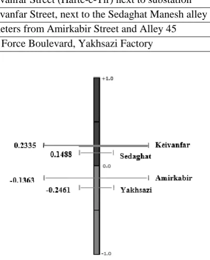
this case, all alternatives will be comparable and the larger net flow means the superior alternative. This means that if the amount of net flow “a” is greater than the amount of net flow “b”, then the alternative “a” is preferred than alternative “b” and if the amount of outranking net flow of two alternatives equals, then they will be placed in same ranking. Figure 6 shows the complete ranking of alternatives based on the output of PROMETHEE II. As seen, the obtained results of complete ranking in PROMETHEE II are exactly similar to the results of the partial ranking in PROMETHEE I which demonstrates the compatibility of judgments and proves the high reliability of the research results. Table 5 presents the obtained results of the complete ranking of alternatives.
Table5. Complete ranking of potential location for construction of automated parking lot Potential location for construction of automated parking lot
Rank
Keivanfar Street (Hafte-e-Tir) next to substation 1
Keivanfar Street, next to the Sedaghat Manesh alley 2
8 meters from Amirkabir Street and Alley 45 3
Air Force Boulevard, Yakhsazi Factory 4
Fig5. Complete ranking of alternatives based on PROMETHEE II
The diagram presented in Figure 6, which is called the PROMETHEE
rainbow, shows the alternatives from the highest to the lowest ranking (from left to
right). The PROMETHEE's rainbow is a PROMETHEE II separation view that completes the ranking. The stacked slices of each alternative show the components of the net flow of each alternative. The criteria placed on the related stacked slices have a positive effect on ranking related alternative and others in the bottom of the related stacked slices have a negative effect on ranking corresponding alternative. For example:
Keivanfar: criteria No. 1, 13, 14, 15 and 16 have a positive effect on ranking Keivanfar alternative and conversely criteria No. 2, 3, 4, 6, 9, 10, 11, and 12 have a negative effect.
Sedaghat: criteria No. 1, 6, 13, 14, 15, and 16 have a positive effect on ranking Sedaghat alternative and conversely criteria No. 2, 3, 4, 5, 8, 9, 10, 11, and 12 have a negative effect.
Amirkabir: criteria No. 2, 3, 5, 8, 9, 10, 11, 12, and 13 have a positive effect on ranking Amirkabir alternative and conversely criteria No. 1, 4, 6, 7, 14, 15, and, 16 have a negative effect.
Yakhsazi: criteria No. 4, 5, 6, 7, 8, 9, 10, 11 and 12 have a positive effect on ranking Yakhsazi alternative and conversely criteria No. 1, 13, 14, 15, and 16 have a negativeeffect.
Fig6. PROMETHEE’s rainbow chart
Sensitivity Analysis based on the Sub- Criterion Accidents and Accidents
In this section, the durability and reliability of the research results are investigated using sensitivity analysis. Additionally, in this analysis, the changes in the ranking of alternatives based on the gradual increase/decrease in the weight of a criterion is examined. This tool considerably helps decision makers to review the weight of indicators and their outcomes. Figure 7 shows the sensitivity analysis of alternatives based on the sub-criterion of
incidents and accidents from the environmental group, which was recognized as the most important sub-criterion based on the results of weighting by the FANP method. The analysis of Figure 7 shows what changes occur in the ranking of alternatives with the gradual increase/decrease in the weight of a sub-criterion accidents and incidents? As Figure 7 shows, when the weight of a sub-criterion “incidents and accidents” decreased less than 17.72%, the first ranking number is assigned to the location
of Keivanfar Street-next to Sedaghat Manesh alley- which obtains the position of Keivanfar Street-next to the substation-
in the ranking list. In other words, the ranking position of alternatives 1 and 2 are changed.
Fig7. Sensitivity analysis diagram based on the sub-criterion “incidents and accidents”
6- Conclusion and Discussion Nowadays, the problem of lacking a place for parking vehicles, especially in the central and crowded areas of the city, has become a major concern in many populated cities in Iran, especially the city of Qom, which is the second Iranian religious city after Mashhad that attracts many travelers every year. Therefore, in order to reduce traffic in the city center of Qom, especially during religious festivals, the construction of automated parking lots with the least space required rather than other types of parking lots lead to a reduction in the marginal parks and, consequently, smoothes the traffic flow. Various decision-making methods have been used to select the appropriate location for construction parking lots based on the criteria involved in locating. One of these methods is the fuzzy ANP which provides more realistic and reliable results than other methods such as AHP
by considering the possibility of establishing mutual relations among the criteria. In this research, the location of automated parking lots in Qom city with the sustainable development approach has been considered which is a step towards solving the problem of lacking a parking place in this city. For this purpose, first the effective criteria in locating automated parking lots were identified and weighted by ANP method, then the potential locations for construction parking lots in Qom were ranked using the PROMETHEE technique. To do so, after determining the weights of criteria and sub-criteria involved in locating parking lots by FANP technique, the four potential locations for construction parking lots were ranked using FPROMETHEE as follow:
1. Keivanfar Street (Hafte-e-Tir) next to substation.
2. Keivanfar Street, next to the Sedaghat Manesh alley
3. Emam Khomeini Street above Saeedi square, 8 meters from Amirkabir Street and Alley 45
4. Emam Khomeini Street, Saeedi square, Air Force Boulevard, towards Emamzadeh Ebrahim, Yakhsazi Factory
The main limitation of this research is using a questionnaire (Mental Measurement) for those variables that have an objective nature. Due to lack of comprehensive database and managers’ susceptibility, researchers were not able to access real data. According to the results of weighting indicators, the environmental criterion was introduced as the most important criterion in locating automated parking lots. Therefore, it is suggested that managers and decision makers always consider environmental issues such as air pollution, noise pollution, incidents and accidents as the main factors involved in locating parking lots. On the other hand, based on the results of sub-criteria ranking, the sub-criterion “incidents and accidents” was the most important sub-criterion. Hence, by increasing the fines and costs of marginal parks, it is possible to prevent the incidence and accidents caused by marginal parks to a great extent. Some suggestions for future research are as follow:
Use the proposed model and criteria in this study for locating parking lots in other cities.
Researchers can also use other MCDM methods such as BWM (One of the new and highly effective multi-criteria decision-making techniques to weight the criteria and sub-criteria involved in locating as well as ranking the potential places for construction parking lots.
It is suggested that for future studies, the effect of sustainable development components on the location of parking
lots to be investigated using structural equation modeling.
In this study, experts’ opinions were used to determine the internal relations of groups and elements; it is suggested that for future studies researchers use other methods of Soft Operational Research (O.R.) such as DEMATEL.
It is suggested that in future research, the ArcGIS software to be used which provides a better and more obvious picture of the potential locations for construction parking lots, and allows users to simply employ spatial information and descriptive data to create maps, tables, and charts.
7- References
Abbasi, F., & SeyedHosseini, S.M. (2011). Developing the method of locating public parking using GIS in metropolises (case study of 3rd district of Karaj). Journal of City Identity, 5(8), 47-57.(In Persian) Center for Study and Planning of Tehran
City. (2014).(In Persian)
Ebadi, M. (2007). Locating public class parking using the OWA method. Master thesis, Faculty of Earth Sciences, Tehran. (In Persian)
Faranadeh Consulting Engineers. (2008). Second Phase Review of Shiraz Detailed Planning, district 6.(In Persian)
Fosgerau, M., & De Palma, A. (2013). The dynamics of urban traffic congestion and the price of parking. Journal of Public Economics, 105, 106-115.
Francis, Sh. (2013). Urbanism, imagination and reality. Translated by: Habibi, S.M., 6th edition, Tehran: University of Tehran Publications.
Ghanbari, S., Ghazi, A. (2011). Evaluation of different methods of locating in the management of public parking construction in the commercial center of Isfahan using GIS. Quarterly journal of geography and environmental planning, 22(3), 183-198. (In Persian)
Ghasemi, A., Maleki, M.H., Karimi, A. (2015). Prioritization of the development of external relations based on cultural values using cluster analysis and hierarchical analysis process. Public Administration Management, 10, 57-72.(In Persian) Ghazi, A. (2004). Providing Appropriate Method
for Locating Public Parking Using GIS (Case Study: Central Section of Isfahan City. Master thesis, Shahid Beheshti University.(In Persian)
Ghodsipoor, H. (2002). Analytical Hierarchy Process. 7th edition, Tehran: Amirkabir University of Technology. (In Persian) Gogus, O., & Boucher, T. O. (1997). A
consistency test for rational weights in multi-criterion decision analysis with fuzzy pairwise comparisons. Fuzzy sets and Systems, 86(2), 129-138.
Jelokhani-Niaraki, M., & Malczewski, J. (2015). A group multicriteria spatial decision support system for parking site selection problem: A case study. Land Use Policy, 42, 492-508.(In Persian) Karimi, V., Ebadi, H., & Ahmadi, S. (2007).
Modeling the location of urban facilities using GIS with an emphasis on locating multi-layered parking. Geomatical conference, 86, Tehran.(In Persian)
Mohammadi, J., Kiyoomarsi, H., & Nasiri, Y. (2013). Optimal Location of Urban Parking Using Geographic Information System (GIS) and Analytical Hierarchy Process (Case Study: Central District of Abadeh).
Quarterly Journal of Geographic Space, 13(44), 91-109.
Motkan, A., Shakiba, A., Poorali, S.H., & Ebadi, I. (2007). Application of GIS in locating public class parking by OWA method (Case study: Tehran district1). Geomatics Conference 86, Tehran.(In Persian) Motkan, A., Shakiba, A., Poorali, S.H., &
Ebadi, I. (2009). Decisive and fuzzy decision making in classical parking lots.
Journal of Environmental Sciences, 6(3). (In Persian)
Pass road consultant engineers. (2008). Second Phase Studies of Qom Transportation
and Traffic Project. Qom municipality. (In Persian)
Rashidifard, S.N., Keramatisal, R., & Farokhi, E. (2011). Locating Dehdasht City Parking by using GIS and Network Analysis Model.Eleventh International Conference on Transport and Traffic Engineering. (In Persian)
Roostayi, Sh., Ghanbari, H., Kazemizad, Sh., & Nooriyan, R.(2011). Providing Optimal Location Pattern for Neighborhoods by Using AHP and GIS Method Case Study: 3rd and 4th District of Tabriz.
Quarterly Journal of Geography and Development, 9(23), 163-184.(In Persian) Saei dni ya, A. ( 2004). Green Book of
Municipalities, Vol. II: Urban Land Use.
Tehran: Publications of the Organization of Municipalities and Villages of the country. (In Persian)
Soleymani, A., Parishan, M., & Ala, M. (2014). Locating Multi-layered Parking for CBD Mid-Range Cities with GIS Tool (Case Study: Maragheh City). Quarterly Journal of Geography and Urban Planning of Zagros Landscape 6(20), 117-135.(In Persian)
Talebi, R. (2010). Optimal location of multi-layer parking in Tehran; case study: Tehran Municipality district 7 (By studying various methods of weighing and integrating information such as scoring, AHP Nine Degree and Fuzzy AHP, and index-fuzzy overlapping method as an integration method),
Journal of Urban Management, 8(26), 119-132.(In Persian)
Yaghfoori, H., Fatoohi, S., & Masjedi, N. (2016). Study of spatial distribution of public parking and its optimal location (case study: Shiraz municipality, 2nd and 8th districts). Urban Research and Planning, 7(24), 190-173.(In Persian) Zamani, V. (2010). Locating multi-layered
parking in Qom using ANP multi-criteria analysis method. Master thesis, Isfahan University of Art.(In Persian)
Ecological and Economic Principles to Improve the Route Network of
Urban Transport
Nikolay Dmitrichenko
Faculty of Automotive and Mechanical Engineering, National Transport University, Kyiv, Ukraine
Viktoriia Khrutba*
Department of Ecology and Safety of Vital Functions, Faculty of Automotive and Mechanical Engineering, National Transport University, Kyiv, Ukraine
Oksana Spasichenko
National Transport University, Kyiv, Ukraine
Yuliia Khrutba
Department of Transport Law and Logistics, Faculty of Management, Logistics and Tourism, National Transport University, Kyiv, Ukraine
Received: 2017/05/10 Accepted: 2017/10/23
Abstract: The transport system of many Ukrainian cities does not meet the EU standards
and requirements. There is a need to improve urban transport networks, to use transport potential efficiently on the basis of environmental logistics and to improve environmental safety as one of the principles of sustainable transport development. The systems model to create an ecologically safe logistics system of public transport determines the relationship between input parameters (transport system indicators), output parameters (ecological and economic indicators of the route network) and controlling parameters, restrictions, uncontrolled parameters and environmental impact assessment. To model the route network, linear programming (a transport task) has been used as a method with the criteria for optimizing the indicators of economic, ecological and social assessment. A target function is an additive function indicating economic costs, environmental and social losses in passenger and / or freight transportation with weight ratios. It describes the cost of the logistics system. The weight ratios of the importance of economic and ecological indicators are chosen for each route depending on the specifics of transportation. It enables to choose the scheme of transportation by the integration index. (Optimal or compromise plan is suggested according to economic or ecological indicators). The developed approach has been applied to improve the route network of public transport in Kyiv based on ecological and economic principles. Network optimization of only three routes has enabled to increase the income and reduce expenses for passenger transportation. Meanwhile, harmful emissions - CO, CmHn, NOx, PM, СO2 - have also decreased.
Keywords: Ecologically-Oriented Logistics System; Ecological and Economic Assessment,
Green Logistics, Transport System, Route Network, Optimization
JEL Classification: K32, Q01, Q51, Q56
* Corresponding author: [email protected]
To cite this document: Dmitrichenko, N., Khrutba, V., Spasichenko., O. & Khrutba, Y. (2018). Ecological and Economic Principles to Improve the Route Network of Urban Transport. Urban
Economics and Management, 6(1(21)), 131-144 www.iueam.ir
Indexed in: ISC, EconLit, Econbiz, SID, RICeST, Magiran, Civilica, Google Scholar, Noormags, Ensani. ISSN: 2345-2870
1 - Introduction
The transport strategy of Ukraine for the period up to 2020 determines the key problems, goals, principles and priorities of developing the transport system in view of national needs and interests. It offers political, economic, organizational and legal measures. In 2020 the volume of cargo transportation is expected to increase by 43.1% and to make up 2.535 billion tons compared with 2008. Cargo handling at state sea ports is expected to increase by 43.2% and to make up 233.4 million tons. The volume of passenger transportation is expected to increase by 30.4% and to make up 10. 867 billion passengers.
The efficiency of transport activity depends on the efficiency of other industries, and hence the economic well-being of the country. However, the operation of motor vehicles results in a significant environmental pollution. Greenhouse gas emissions (СО2,
СН4), ozone-depleting substances (fluorine,
chlorinated hydrocarbons, i.e. carcinogens), harmful substances (NOx, SО2, CO, NH3,
solvents), dust are released into the atmosphere. As a result of intense movement due to asphalt coating wear, the amount of solid particles in the air increases, carcinogenic particles in particular. Considerable environmental damage is caused by sewage polluted by waste oils from transport enterprises. Materials used during vehicle repair, maintenance and refueling also pollute the environment. Lubricants (motor oils, transmission fluids, etc.), mineral-based liquids used for hydraulic systems, adhesives and sealants based on formaldehyde and epoxy resins and used for car repair and manufacture are all toxic. The amount of emissions from mobile sources in Ukraine is more than 1.7 million tons annually
which accounts for more than one third of total emissions.
The impact of transport activity on human health is due to constant influence of air pollution, noise, water and soil pollution (especially in accidents when transporting dangerous goods and cargo) on mental health. The pollution of urban areas by motor transport emissions is one of the reasons for the increased morbidity rates among the population. This problem is particularly acute in large cities of Ukraine, such as Kyiv, Dnipro, Kharkiv, Odesa and others.
Kyiv is a large administrative center with a multimillion population. In order to meet the needs of its residents and ensure the functioning of all production and services industries, it requires regular passenger and cargo transportation. The implementation of the City Development Strategy until 2025 for transport and transport infrastructure depends on the effective policy of sustainable development and “ecologization” of the economy in order to reduce its energy and resource intensity and anthropogenic pressure. One of the global social, economic and environmental problems requiring urgent actions for Kyiv is the optimization of the route network of the city transport provided that the emission of pollutants from mobile sources is reduced. Reducing the impact on climate change through the implementation of the sustainable transport policy also provides a number of other benefits. They include air quality improvement, vehicle noise reduction, road safety improvement, and a range of social and economic benefits.
It is quite obvious that sustainable economic development of the city is not possible without the development of transport infrastructure and the city's
transport network based on the business strategy of environmental logistics. The decisions of the functional level are mostly aimed at increasing the efficiency of fuel consumption in trucking, the optimization of vehicle routes and energy saving. Hence, an important direction in reducing the man-made environmental burden and public spending is the optimization of the route network of the city transport.
Thus, taking into account that the transport system of many Ukrainian cities still does not meet EU standards and requirements, there is a need to solve a range of problems. It is necessary to improve urban transport networks, to use transport potential efficiently on the basis of environmental logistics and to improve environmental safety as one of the principles of sustainable transport development.
Due to the above-mentioned problems, this study attempts to develop an approach to improve the route network of urban transport according to economic efficiency and environmental safety criteria. Thus, the following issues have been raised:
1. What parameters influence the “sustainable” development of the city transport system and route network?
2. What is the general criterion of environmental and economic efficiency enabling to assess the public transport route?
3. How to optimize the city's public transport routes according to ecological and economic indicators using the results of modeling?
2– Literature Review
Many problems and issues related to environmental impact of transport activity are tackled in modern scientific literature.
Ye.V. Krykavskiy (2006) investigates the evolution of the supply chain and its impact on a logistics operator. He describes the experience of logistics operators in Europe. He also justifies the development strategy of carriers or transport companies in the domestic market towards the logistics operator or integrator.
Alan McKinnon, Sharon Cullinane, Michael Browne and Anthony Whiteing, (2010) in a study entitled “Green Logistics. Improving the Environmental Sustainability of Logistics” says that the scientific analysis of approaches, methods and tools of environmental (green) logistics, logistics of resource conservation and waste forms environmentally oriented strategies of logistics entities’ behavior.
Halyna Rodashchuk (2013) suggests the optimal route network for passenger transportation in rural areas. As a result of scientific research and calculations, a tree of minimum length has been created which is the network transport problem-solving. The task of covering the network, where the desired tree consists of a set of the shortest paths from the source to all nodes, has been performed after analyzing the methods of Dijkstra (determining the shortest path between two graph vertices) and Floyd (determining the shortest paths between all graph vertices).
Oksana Seroka-Stolka (2014) highlights the key factors that can influence the development of a green logistics concept in companies as an element of sustainable development.
Smeshek et al., (2014) in a study entitled “Environmental logistics as a factor of reducing the resource intensity of enterprises. Service market of integrated transport systems and applied problems of logistics” suggest that environmental impact of enterprises has been mostly investigated
only for individual logistics processes, such as transportation, warehousing, or waste management processes.
Allen et al., (2016) in a study entitled “Analysis of road freight in London and Britain: traffic, activity and sustainability” state that last-mile urban freight contributes to its traffic congestion and poor air quality. They examine the development of road freight transport operations in London.
Lyshtva (2015) considers an integrated approach to optimizing the system of urban passenger transport (the case studied: transport problems of Kyiv).
Mateichyk (2016) in a study entitled “The peculiarities of Modeling the Indicators of Vehicle Environmental Safety in Motion in a Traffic Flow” examines the indicators of vehicle environmental safety under urban traffic conditions using mathematical modeling methods. He also considers the integration of ecological component in logistics processes.
However, the determined problem needs further research with regard to constant economic change and increasing environmental degradation from transport activity.
3 – Theoretical Background
The globalization of transport chains, high volatility of prices of fuel, energy
and other resources, the regulation on greenhouse gas emissions result in environmental constraints taken into account when creating the logistics system. The ecological and economic approach based on the concept of sustainable development is an important way regulating all activities of transport enterprises. An important factor of a “sustainable” transport development model is the ecological optimization of end-to-end logistics flows. They involve the supply, production and sales sectors, including integration processes of suppliers of raw materials, semi-finished products, etc., with end consumers. The ecologization of transport logistics is based on the integration and coordination of environmental, social and economic aspects within the urban transport system aimed at ecologically-oriented logistics management of city development. In this case, to achieve the goal, the coordination of economic results, social and environmental effects should be based on the principles of multicriteria optimization (Politechnika Rzeszowska, 2015).
An efficient tool for adjusting economic, social and environmental requirements is the optimization of passenger and cargo flows of the city logistics system and the reduction of environmental impacts from the operation of certain spheres of logistics (Table 1).
Table1. Environmental impact of certain spheres of logistics activities
Functional sphere of
logistics Environmental impact
Supply logistics
the increase of solid waste when storing physical resources
touching ecologically dangerous ingredients when handling and loading goods loading on soils when storing physical resources and delivering them from suppliers Information logistics electromagnetic radiation when transmitting the information by means of
communication
Sales logistics the increase of solid waste when selling goods
goods spilling, leakage, evaporation due to poor quality packaging Production logistics
the increase of using manufacturing resources
the use of land for manufacturing facilities and waste storage the increase of noise and vibration in the adjacent territory
Transport logistics
vehicles emissions into the atmosphere sewage from transport enterprises waste from transport activity
the use of cheaper fuels processing products of which have a negative impact on the environment and human health
noise and vibration pollution When creating the route network of the city, the principle of environmental logistics involves forecasting the quantity and quality of environmental degradation effects from transport activity. In future it should take into account methods and ways to reduce the influence of anthropogenic factors on environmental pollution. The
main tasks in this case are to reduce the harmful impact of transport logistics processes on the environment and to reduce the consumption of non-renewable or partially renewable energy resources in the logistics chain. Strategic goals of environmental logistics for the logistics chain are shown in Fig. 1.
Fig1. Strategically-oriented goals of environmental logistics when creating the city's transport network (Kyiv, NTU, 2016)
The implementation of strategic and tactical goals of environmental logistics includes the following steps:
- the identification of environmental threats of logistics processes and the assessment of their implementation risks;
- forecasting the consequences from the implementation of environmental threats
- the development of organizational, technical, technological, scientific measures aimed at eliminating dangerous threats,
1. The optimization of logistics processes aimed at minimizing
negative impact of noise, vibrations, air pollutants: greenhouse gas (СО2, СН4);
ozone-depleting substances (fluorine, chlorinated hydrocarbons, i.e. carcinogens); harmful substances (NOx, SО2,
CO, NH3, solvents); dust.
2. Waste recycling (glass, paper, aluminum, asphalt, iron, fabrics
and various types of plastics).
1. Stimulation of logistics processes aimed at using alternative energy sources -
interchangeable for such energy resources: fossil fuels
(coal, oil, natural gas).
2. Ecologically-oriented logistics management of partially renewable resources:
water, wood, land. Re
d u cin g th e co n su m p ti o n o f n o n -re n ewa b le an d p arti all y re n ewa b le n atu ra l re so u rc es Re d u cin g h arm fu l em issio n s wit h in m an u fa ctu rin g fa cil it ies a n d i n to t h e en v iro n m en t
reducing their risks and the impact of their implementation;
- including environmental costs in logistics processes.
In view of the above-mentioned, the creation of a route network, the development of a sustainable transport system in a city should be aimed at finding the optimal compromise. In this case, the economic and social benefits of transport would be maximized and the environmental and economic costs associated with it would be minimized.
4– Research Method
The basis of studying the mechanisms to improve the environmental performance
of urban transport systems is systems analysis technique. It involves identifying the properties of the system to determine the structural relationships between its variables and elements. The first step is to create a “black box” model. It enables to show the inputs and outputs of the system necessary to study its functioning. This is a model of “input-output” type (Figure 2). When constructing such a model, the relation between these inputs and outputs is established. The model reflects the main properties of the system. It is integral and relatively isolated due to the connection with the environment.
Fig2. A black box model to create environmentally safe route network of the city
The “input” of the system is such indicators of the transport system as the state of vehicles, vehicle technical characteristics, route characteristics, passenger / cargo flow, road conditions, skills and experience of employees. Ecological and economic indicators of the city route network - the level of environmental impacts, financial indicators of the logistics system - is the "output" of an
environmentally safe logistics system in passenger and cargo transportation. External influences are formed by available determin ed controlling parameters, restrictions, uncontrolled stochastic parameters and the assessment of environmental impact of the logistics system. The main parameters of the systems model are shown in Table 2 (Zarządzanie i Marketing, 2012).
Social and environmental safety of the city route network
A change in ecological and economic indicators of the transport system and the
environment, Yj Restrictions, Gp
Uncontrolled (stochastic) parameters,
Vl
Controlling (determined) parameters, Um
Controlling parameters Managing environmentalsafety
of the route network Route network indicators, Хі
- Mass flow - Energy flow
- Information flow
Table2. Parameters of the systems model to create an e environmentally safe logistics system
Input parameters
1 2 n
i x,x ,...,x
X ,where x1,x2,….,xnare indicators of the transport system - the state of vehicles, vehicle technical characteristics, route characteristics, passenger / cargo flow, road conditions, skills and experience of employees
Output parameters
1 2 k
j y,y ,....,y
Y , where y1, y2,..,ykare ecological and economic indicators of the city route network - the level of environmental impacts, financial indicators of the logistics system
Restrictions
1 2 3
p g,g ,g
G , where g1 is the value of the maximum allowable concentration of hazardous substances, g2 is restrictions determined by liability for violating traffic rules,
3
g isrestrictions determined by liability for breaking environmental legislation Controlling
parameters
1 2 3 4 5
m u ,u ,u ,u ,u
U ,where u1is a regulatory framework for transport activities, u2 isorganizational, u3 is technological, u4 is financial and economic, u5 is information support of the logistics system
Uncontrolled parameters
1 2 3 4
l v,v ,v ,v
V , where v1 ispolitical influences, v2 is social factors, v3 is climate conditions, v4 is traffic accidents (crashes, repairs, traffic jams, etc.)
The assessment of environmental
impact of the logistics
system
D,Pel,І,A,O,Pа
IPE , where D is the time of action; Pelis the possibility to eliminate negative consequences; Iis the way of influence; Ais the scope; Ois the origin;
а
P is the possibility to accumulate effects. Managing the
result of the impact
а el
P O A І P
D
The results of the systems analysis enabled to determine the mechanisms of reducing the level of anthropogenic pressure on the environment when creating the route network of urban transport. They involve three groups of interconnected means and measures aimed at minimizing environmental impacts through regulation and control of the corresponding activities:
1. Legislative measures include the adaptation of Ukrainian environmental legislation and transport law to European Union legislation. Ensuring the implementation of international environmental standards for vehicles and motor fuels.
2. Organizational and administrative measures include the establishment of institutions enabling to provide integrated management of urban and transport planning, development, the implementation
and promotion of integrated plans for sustainable urban mobility, communication strategies, and others.
3. Technical and economic measures include timely vehicle inspection and maintenance, the use of environmentally friendly fuel, the timely restoration of a rolling stock by repairing trolleybuses, the reconstruction of traction substations and the replacement of worn-out equipment. They also include the elimination of the accident condition of contact systems; the renewal of a rolling stock with new trolleybuses domestically produced. The measures also include the optimization of the city traffic routes taking into account the environmental impact of transport activity based on the route network modeling.
A rational route network taking into account the requirements of passengers