The Amazon River Basin
CE 397 – Transboundary WatersChristine Lynch INTRODUCTION
The Amazon Basin is the largest river basin in the world, and is not only of importance to the seven countries across which it spreads, but to the entire world through its effect on global climate. The drainage basin covers an area of over 6,100,000 km2, and covers over one-‐third of the South American continent. The discharge from the Amazon River, about 220,800 m3/s, comprises over twenty percent of the total discharge from all global rivers. In fact, the discharge from the Amazon exceeds the combined discharge of the world next seven to nine largest rivers. The basin has far reaching effects, altering the color and salinity of the Atlantic for almost 200 miles, and producing about twenty percent of the Earth’s oxygen.
BASIN COMPOSITION
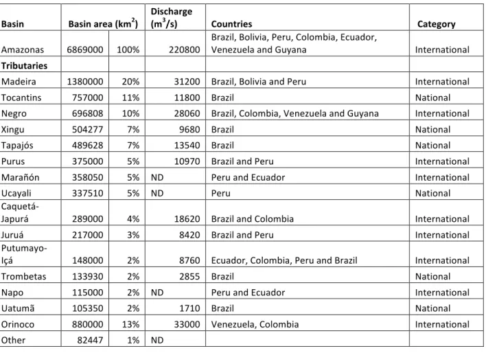
The Amazon Basin includes land from seven different countries: Brazil, Peru, Ecuador, Bolivia, Colombia, Venezuela, and Guyana; although the Amazon rainforest extends further and includes Suriname and French Guiana. The basin consists of at least fifteen sub-‐basins, containing over 200 tributaries. Sixty-‐four percent of the sub-‐basins, by area, are international sub-‐basins, highlighting the largely international nature of the Amazon Basin. The majority of the basin, approximately sixty-‐nine percent, is located within Brazil, although Bolivia is the country most covered by the basin, owing about sixty-‐six percent of its area to the Amazon Basin, followed closely by Peru at sixty percent.
TABLE 1. SUB-‐BASIN MAKEUP OF THE AMAZON BASIN
Basin Basin area (km2) Discharge (m3/s) Countries Category Amazonas 6869000 100% 220800 Brazil, Bolivia, Peru, Colombia, Ecuador, Venezuela and Guyana International
Tributaries
Madeira 1380000 20% 31200 Brazil, Bolivia and Peru International
Tocantins 757000 11% 11800 Brazil National
Negro 696808 10% 28060 Brazil, Colombia, Venezuela and Guyana International
Xingu 504277 7% 9680 Brazil National
Tapajós 489628 7% 13540 Brazil National
Purus 375000 5% 10970 Brazil and Peru International
Marañón 358050 5% ND Peru and Ecuador International
Ucayali 337510 5% ND Peru National
Caquetá-‐
Japurá 289000 4% 18620 Brazil and Colombia International
Juruá 217000 3% 8420 Brazil and Peru International
Putumayo-‐
Içá 148000 2% 8760 Ecuador, Colombia, Peru and Brazil International
Trombetas 133930 2% 2855 Brazil National
Napo 115000 2% ND Peru and Ecuador International
Uatumã 105350 2% 1710 Brazil National
Orinoco 880000 13% 33000 Venezuela, Colombia International
Other 82447 1% ND
CLIMATE EFFECTS
The Amazon rainforest and, consequently, the Amazon Basin, are of huge importance to the local and global climate. In a normal year, the rainforest consumes nearly two billion tons of carbon dioxide. The forest not only acts as a carbon sink but a heat sink, absorbing the equatorial radiation from the sun and using it to grow, as well as to power its evapotranspiration, which in turn releases the energy in the form of tropical storms which recycle between one half and two-‐thirds of the regional rainfall. These tropical storms also serve to re-‐distribute this heat throughout the globe. Seventy-‐five percent of the energy that drives atmospheric circulation is derived from the heat released during tropical rainfall.
The forest not only reduces temperatures both in the region and throughout the globe, but also regulates local temperatures, reducing both the atmospheric and soil temperature fluctuations
considerably when compared to pasture land.
The self-‐regulating Amazon Basin is still strongly affected by major weather patterns, however, as evidenced by the effects of El Niño and La Niña. These weather phenomena, characterized by higher (El Niño) or lower (La Niña) than normal temperatures in the Equatorial Pacific, dramatically alter rainfall
in the basin, with the former resulting in droughts and the latter, floods. These occurrences have far-‐ reaching consequences, affecting economic activities such as hydropower generation, agriculture, and fishing, as well as mechanisms of environmental importance such as sediment transport, forest growth, and ecosystem alteration. The Amazon’s susceptibility to the fluctuations of El Niño should serve as a warning of the possible effects global climate change could have on the basin, in addition to the effects the basin could have on global climate change.
ECONOMIC IMPACTS
The Amazon Basin, though comprising a significant portion of its home countries’ area, contributes a disproportionately small amount to their economies. For example, in 1990, the Brazilian Amazon contributed 3.5% of the country’s gross domestic product (GDP), despite covering over 45% of its area.
Economic exploitation of the Amazon is difficult due to the many tradeoffs inherent in any use of the land. Dams to provide hydropower inevitably harm the fishing industries, by interrupting fish migration and replacing river habitats with lakes. Dams have also been observed to harm upstream Brazil Nut collection and agriculture through its flooding of forested or developed lands. Although dams have been touted as “green” energy sources, recent studies suggest that they are in fact significant greenhouse gas emitters, with one study claiming that the emissions from hydroelectric production of the Curuá-‐Una Dam in Para, Brazil, were 3.5 times higher than if the electricity had been produced though fossil fuel burning methods instead. Equitable division of the electricity produced from such dams is also difficult if not impossible to achieve, due to the dearth of national rivers and sub-‐basins. Mining has been demonstrating its ability to damage the environment through the release of mercury and arsenic into the rivers, resulting in high mercury levels in local fish and the people who consume them, as well as by releasing excessive silt into water bodies, which in Oriximiná, Pará, almost destroyed Batata Lake through extensive silting. Commercial and industrial fishing techniques have harmed the indigenous fish populations, through mechanisms including over exploitation of some species and introduction of alien species. Timber extraction and agriculture of course result in deforestation, which destroys habitats and has significant impacts on the climate, but the largest contributor to deforestation is actually cattle ranching. Cattle ranching is a major economic activity in Brazil, the world’s largest beef exporter, and has devastating impacts on the environment through deforestation and methane
production. Rates of deforestation have been shown to correlate with international commodity price fluctuations of beef and soya, demonstrating the important role of economy in the Amazon’s fate. Leslie Taylor, in The Healing Power of Rainforest Herbs, claims that this battle between the environment and economic returns is not inevitable, and that sustainable development of the Amazon can in fact be more profitable than cattle ranching or lumber production.
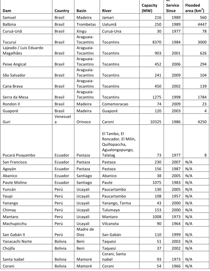
TABLE 2. DAM DISTRIBUTION IN THE AMAZON BASIN
Dam Country Basin River Capacity (MW) In Service
Since Flooded area (km2)
Samuel Brasil Madeira Jamari 216 1989 560
Balbina Brasil Trombetas Uatumã 250 1989 4447
Curuá-‐Unã Brasil Xingu Curuá-‐Una 30 1977 78
Tucuruí Brasil Araguaia-‐Tocantins Tocantins 8370 1984 3000
Lajeado / Luis Eduardo
Magalhães Brasil
Araguaia-‐
Tocantins Tocantins 903 2001 626
Peixe Angical Brasil Araguaia-‐Tocantins Tocantins 452 2006 294 São Salvador Brasil
Araguaia-‐
Tocantins Tocantins 241 2009 104
Cana Brava Brasil Araguaia-‐Tocantins Tocantins 450 2002 139 Serra da Mesa Brasil Araguaia-‐Tocantins Tocantins 1275 1998 1784
Rondon II Brasil Madeira Comemoracao 74 2009 23
Guaporé Brasil Madeira Guaporé 120 2003 4
Guri Venezuela Orinoco Caroní 10325 1986 4250
Pucará Pisayambo Ecuador Pastaza
El Tambo, El Roncador, El Milín, Quillopaccha, Agualongopungo,
Talatag 73 1977 8
San Francisco Ecuador Pastaza Pastaza 230 2007 N/A
Agoyán Ecuador Pastaza Pastaza 156 1987 N/A
Abanico Ecuador Santiago Abanico 38 2005 N/A
Paute Molino Ecuador Santiago Paute 1075 1983 N/A
Yuncán Perú Ucayali Paucartambo 130 2005 N/A
Yaupi Perú Ucayali Paucartambo 108 1957 N/A
Yanango Perú Ucayali Yanango, Tarma 43 2000 N/A
Chimay Perú Ucayali Tulumayo 153 2000 N/A
Mantaro Perú Ucayali Mantaro 1008 1973 N/A
Machupicchu Perú Ucayali Vilcanota 90 1964 N/A
San Gabán II Perú Madre de Dios San Gabán 110 1999 N/A
Yanacachi Norte Bolivia Beni Taquesi 51 2002 N/A
Chojlla Bolivia Beni Taquesi 37 2002 N/A
Santa Isabel Bolivia Mamoré Corani, Santa Isabel 93 1973 N/A
CLOSING REMARKS
The Amazon Basin is, without a doubt, of global importance and a key component of the carbon cycle, giving it an important role in the prevention or progression of global climate change. However, is it the responsibility of the Amazon countries to sacrifice their economic potential for the greater good of all? Should the international community somehow compensate for or contribute to the maintenance of the Amazon Basin? After all, most first world countries have deforested much of their own land. Or is it possible for the Amazon countries to progress economically with only sustainable development of the Amazon? It is clear that the international market ultimately plays a large role in the Amazon’s worth, and that until the health of the Amazon does not have to be traded for economic development, we can never expect the Amazon Basin to be truly protected, and.
QUESTIONS
Is it truly possible for countries to sustainably harvest from the Amazon in a way that is not less profitable than alternative methods?
If not, is it the responsibility of the Amazon countries to sacrifice their economic potential for the good of the rainforest?
REQUIRED READING: This reading provides a background on some of the individual rivers in the Amazon Basin and their economic activities.
BARTHEM, R.B.; P. CHARVET-‐ALMEIDA; L.F.A. MONTAG & A.E. LANNA. 2004. Amazon Basin, GIWA Regional assessment 40b. Sweden, University of Kalmar/UNEP, pp 17-‐18.
Full report available online
(http://www.unep.org/dewa/giwa/areas/reports/r40b/giwa_regional_assessment_40b.pdf) but required sections excerpted below for convenience:
Rivers of the Andes
Ucayali and Marañón rivers. The Inca Empire was the most famous civilization of the Ucayali River. Its capital, Cuzco, was established on the Apurimac River, in the Basin’s headwaters. The mountains have a long history of human alteration extending thousands of years, but the valley and the lowlands are well preserved. Fishing is an important economic activity in the lowlands, mainly around the cities of Pucallpa and Iquitos. The Marañón River was the principal connection between the Peruvian Amazon and the Pacific in the recent past, and now it is the main pipeline route for the export of oil. In addition to oil extraction, numerous copper, zinc, iron, mercury, antimony and gold mines occur in the headwaters of these rivers (Goulding et al. 2003).
Madeira River. The Madeira River, composed of Mamoré, Beni and Madre de Dios rivers, is the main source of sediments of the Amazon Basin. The foothills of the Andes exhibit a sequence of habitats that change from snowfall streams to the large rivers at the base of the mountains. Although the biodiversity increases downstream, the chemical processes and species endemic to the high altitude reaches of these rivers make them an important area for the Basin. The confluences of the Andean rivers and the rivers of the Brazilian Shield is observed along a succession of rapids and falls located above the city of Porto Velho. Below this point, the River is calm and navigable. The largest floodplain areas are located in Bolivia, in the flooded savannahs. These areas are inundated with the floods of the rivers and by local rainwater (Goulding et al. 2003). One of the largest alluvial gold mines within the Amazon Basin is located along the Madre de Dios River (Núñez-‐Barriga & Castañeda-‐Hurtado 1999).
Putumayo-‐Içá and Caquetá-‐Japurá. Although, these Andean rivers may have the most preserved catchments in the entire Amazon Basin, the foothill region has been altered in areas where
communities, primarily of indigenous people, have expanded along the road and cocoa production has increased. Fishing is an important activity in the lower river, mainly in the Caquetá River and gold exploitation occurs along the Colombian and Brazilian border (Férnandez 1991, Goulding et al. 2003). Purus and Juruá rivers. The Purus and Juruá rivers are different from other white-‐water rivers in the Andean region because their headwaters are situated below 500 m altitude, although, in the past, they were connected with the Andes. As a result of geological changes these rivers now drain a desiccated landscape formed by an older alluvium deposit and carry large quantities of suspended solids
(Clapperton 1993). These rivers have one of the largest floodplain areas of the Amazon Basin, which is explored by professional fishermen from Manaus (Batista 1998, Petrere 1978). In the headwaters, inhabited by Indians and small communities, several areas have been designated for ethnic groups and are protected from extractive activities (Goulding et al. 2003).
Rivers of the Old Shields
Guyana Shield
The Guyana Shield is located in the north of the Amazon Basin and is shared by Brazil, Venezuela, Guyana, Suriname and French Guiana.
Trombetas, Jari, Araguari and other rivers. Most of the drainage area of these rivers is located in the Guyana Shield, which is characterised by the falls and headwaters of small streams. Large industrial operations, such as the extraction of bauxite in the Trombetas River, the extraction of kaolin and paper production in the Jari River and the extraction of manganese in the Araguari River occur in these basins (Barthem 2001).
Negro River. The Negro River is the largest tributary of the Amazon River located in the Guyana Shield. Several floodplains in the catchment that are flooded by overflow from the Negro River are important, such as the Anavilhanas archipelago in the Negro River and the unnamed archipelago, between Padauari/Demini and Branco rivers (Goulding et al. 1988). In addition, forests in the catchment are periodically flooded by the rain and, as a consequence, creates another type of flooded environment that covers large contiguous areas close to the margins of the Negro and Branco rivers as well as in the
headwaters of its tributaries. In the Branco River, the savannah that is periodically flooded by rain is an environment that favours cattle and rice cultivation and, moreover, it is an area prone to fires during dry periods. The falls and headwaters of the rivers are areas subjected to more severe environmental impacts, such as mining. Conservation depends on the enforcement of an environmental law, which is hindered by the expansion of mining activities in this area (Barthem 2001).
Brazilian Shield
The Brazilian Shield is located in the southern Amazon Basin and is located entirely within Brazil. Tocantins River. The catchment of the Tocantins River is one of the most altered areas of the Amazon Basin. This region possesses two large hydroelectric dams, one at Tucuruí in the lower Tocantins River, and the other at Lageado, in the upper Tocantins River, and the construction of 25 more is predicted (Leite & Bittencourt 1991). Moreover, its headwaters are altered by agricultural activities to the south of Pará and north of Tocantins, as well as by present and past mining activities.
Xingu River. The ichthyofauna of the Xingu River above the waterfall at Altamira is completely different from that of the lower sections of the River. The fauna and the ecology of this system are not sufficiently known and the main impacts are related to mining and agricultural activities in its headwaters.
Tapajós River. Of the rivers that drain the Brazilian Shield, the Tapajós River is the most altered by mining activities in its headwaters and also by dredging. Unfortunately, knowledge of the ichthyofauna and ecology of this drainage system is still insufficient to evaluate the dimension of the impact of this activity (Barthem 2001).
The tributaries of Madeira River. The headwaters of the Madeira River are located in the Andean slopes, but its tributaries drain the Brazilian Shield. The main impacts in this area are caused by mining, construction of Samuel’s Hydroelectric Dam on the Jamari River, and intense agricultural activity in its headwaters. Information on the fauna and ecology of these tributaries is lacking. The Madeira River area and regions close to its tributaries have been studied more often. However, mercury contamination is known in the area and the disturbances of the mining dredges on the migration of the great catfishes have been mentioned by local fishermen.