Langdon East
Conceptual Scheme
MUNICIPAL DISTRICT OF ROCKY VIEW NO. 44 BYLAW C-6135-2005
A Bylaw of the Municipal District of Rocky View No. 44 to adopt the attached Schedule ‘A’, the “Conceptual Scheme”, pursuant to Divisions 7 and 12 of Part 17 of the Municipal Government Act.
WHEREAS the Council of the Municipal District of Rocky View No. 44 has received an application to adopt a Conceptual Scheme to provide a framework for subsequent redesignation, subdivision and development in a portion of the NE ¼ 23-23-27-W4M; as shown on Schedule ‘A’ attached to and forming part of this Bylaw; and
WHEREAS a notice was published on Tuesday, September 20, 2005 and Tuesday, September 27, 2005 in the Rocky View Weekly, a newspaper circulating in the Municipal District of Rocky View No. 44, advising of the Public Hearing for Tuesday, October 18, 2005; and WHEREAS Council held a Public Hearing and have given consideration to the representations made
to it in accordance with Section 692, Section 230 and Section 606 of the Municipal Government Act, being Chapter M-26 of the Revised Statutes of Alberta, 2000, and all amendments thereto.
NOW THEREFORE the Council enacts the following:
1. That the Conceptual Scheme be adopted to provide a framework for subsequent redesignation, subdivision and development in a portion of the NE ¼ 23-23-27-W4M; as shown on Schedule ‘A’ attached to and forming part of this Bylaw; and
2. This Bylaw shall come into effect upon the date of its third and final reading thereof.
DIVISION 4 File: 03223004 - 2003-RV-110
First reading passed in open Council, assembled in the City of Calgary, in the Province of Alberta, on Tuesday, September 13, 2005, on a motion by Councillor Habberfield.
Second reading passed in open Council, assembled in the City of Calgary, in the Province of Alberta, on October 18, 2005, on a motion by Councillor Habberfield.
Third reading passed in open Council, assembled in the City of Calgary, in the Province of Alberta, on October 18, 2005, on a motion by Councillor McLean.
SCHEDULE ‘A’
FORMING PART OF BYLAW C-6135-2005
A Conceptual Scheme affecting the NE ¼ of 23-23-27-W4M.
A Land Use Concept and Policy Framework for the NE ¼ of 23-23-27-W4M comprising approximately ± 120.60 acres (± 48.75 ha).
Langdon East
Conceptual Scheme
August 2005
Prepared for the M.D. Rocky View No. 44
By Planning Protocol Inc.
3916 – 1 Street N.E
Calgary, Alberta
TABLE OF CONTENTS
1.0 Introduction...5
1.1 Purpose... 5
2.0 Conceptual Scheme Objectives...6
3.0 Conceptual Scheme Plan Area...7
3.1 Planning Area Location ... 7
3.2 Definition of Planning Area... 7
3.3 Boundaries of Planning Area ... 7
3.4 Current Land Use... 10
3.5 Community Context and Land Use... 10
4.0 Physical Site Features ...13
4.1 Topography ... 13 4.2 Subsurface Conditions ... 13 4.3 Hydrology ... 13 4.4 Vegetation ... 16 4.5 Existing Structures ... 16 4.6 Environmental Considerations... 16 5.0 Land Use ...17
5.1 Cell 1 – Single Family Residential ... 17
5.2 Cell 2 – Multi-family Residential ... 20
5.3 Cell 3 – Business Commercial... 20
5.4 Cell 4 – Business Light Industrial... 20
5.5 Cell 5 – Public Services ... 21
6.0 Subdivision and Development Sequence...22
6.1 Single Family Residential ... 22
6.2 Multi Family Residential ... 23
6.3 Business Park ... 24
6.4 Municipal Reserve & Municipal School Reserve... 25
6.5 Public Utility Lots... 27
6.6 Phasing... 28
7.0 Urban Design...31
7.1 Architectural & Massing Scheme ... 31
7.2 Crime Prevention Through Environmental Design ... 33
7.3 Landscape Guidelines ... 34
8.0 Servicing...35
8.4 Stormwater Management ... 40 8.5 Garbage Disposal ... 42 8.6 Light Standards ... 42 8.7 Private Utilities ... 42 9.0 Emergency Services ...44 9.1 Fire ... 44 10.0 Implementation ...45 FIGURES Figure 1 – Regional Location ...8
Figure 2 – Property Boundary...9
Figure 3 – Surrounding Land Uses ...11
Figure 4 – Topographical MapFigure 5 – Aerial Photo ...14
Figure 5 – Aerial Photo...15
Figure 6 – Proposed Concept Plan ...Error! Bookmark not defined. Figure 7 – Proposed Land Uses ...Error! Bookmark not defined. Figure 8 – Open Space Scheme...Error! Bookmark not defined. Figure 9 – Phasing Map...30
Figure 10 – Section AA ...Error! Bookmark not defined. Figure 11 – Transportation Map ...37
Figure 12 – Servicing Plan ...Error! Bookmark not defined.
APPENDICIES
Appendix I: Langdon Waterworks Ltd. - Water Services Confirmation Letter
Appendix II: Langdon Waterworks Ltd. - Light Standard Services Confirmation Letter Appendix III: Road X-Sections
SUPPORTING REPORTS
• Phase I Environmental Assessment, PTN NE ¼ Sec. 23-23-27-W4M, Langdon, Alberta, Soil & Enviro. Consultant Inc., January, 2004.
• Preliminary Storm Drainage Plan, Langdon East, Langdon, Alberta, Lee Maher Engineering Associates Ltd., June, 2004.
• Report on the Geotechnical Investigation, PTN NE ¼ Sec. 23-23-27-W4M, Langdon, Alberta, Soil – Teck Inc., June, 2002.
• East Langdon Concept Plan Traffic Impact Study, Olympia Development Ltd., Langdon, Alberta, Urban Systems Ltd., February, 2005.
1.0 Introduction
The Langdon East Conceptual Scheme was prepared at the request the M.D. of Rocky View No. 44. This Conceptual Scheme provides a framework for the subsequent redesignation,
subdivision, and development of the balance of the NE 23-23-27-W4M. Preparation of this Conceptual Scheme has been guided by the Hamlet of Langdon Area Structure Plan, Bylaw C-5049-99, adopted on April 27, 1999 and revised on September 30, 2003, Bylaw C-5780-2003 (herein referred to as the Hamlet of Langdon ASP).
1.1 Purpose
The Conceptual Scheme provides a comprehensive land use rationale for the redesignation and subdivision of 48.75 hectares (120.60 acres) within the NE 23-23-27-W4M. The policies set forth in the Conceptual Scheme are intended to guide the development of the subject lands for single family and medium density residential development, business park development, a school site, and the supporting services and infrastructure. Specific direction is provided to achieve the objectives of the Hamlet of Langdon ASP and this Conceptual Scheme.
2.0 Conceptual Scheme Objectives
2.0.1 To establish a rational policy framework for the redesignation, subdivision, and development of the Conceptual Scheme Area for
residential & business park development, a school site, and the supporting services and infrastructure, in accordance with the Hamlet of Langdon ASP.
2.0.2 To provide a contextual basis to address development constraints and opportunities by describing the physical characteristics within the Conceptual Scheme Area and the surrounding lands.
2.0.3 To institute urban –like design guidelines that assist in establishing a built form that is in character with the Hamlet of Langdon, enhances safety through incorporating CPTED principles, creates a sense of place and community, and minimizes conflicts between different land uses.
2.0.4 Installation of utilities and infrastructure, in accordance with the Servicing Standards for Subdivisions and Road Construction as approved by Council on May 4, 2004, as amended.
3.0 Conceptual Scheme Plan Area
3.1 Planning Area Location
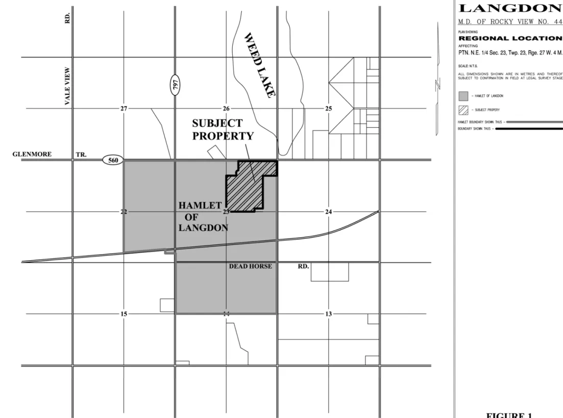
The subject lands are located within the eastern portion of the M.D. of Rocky View within an existing historical settlement known as the Hamlet of Langdon. Specifically, the property is the balance of the NE 23-23-27 W4M, which is located in the northeast section of the Hamlet of Langdon and directly south of Township Road 234 (Hwy. 560). The regional location of the property is shown in Figure 1 – Regional Location.
3.2 Definition of Planning Area
The study area is 48.75 hectares (120.60 acres) in size according to the Certificate of Title, and is comprised of one parcel of land. The legal description of this title is paraphrased as follows: THE NORTH EAST QUARTER OF SECTION TWENTY THREE (23)
IN TOWNSHIP TWENTY THREE (23) RANGE TWENTY SEVEN (27)
WEST OF THE FORTH MERIDIAN
CONTAINING 64.7 HECTARES (160 ACRES) MORE OR LESS EXCEPTING THEREOUT
PLAN NUMBER HECTARES ACRES
ROAD WIDENING 7610020 0.405 1.00
SUBDIVISION 8311498 13.2 32.6
SUBDIVISION 8311932 1.85 4.57
SUBDIVISION 8710378 0.497 1.228
EXCEPTING THEREOUT ALL MINES AND MINERALS AND THE RIGHT TO WORK THE SAME
3.3 Boundaries of Planning Area
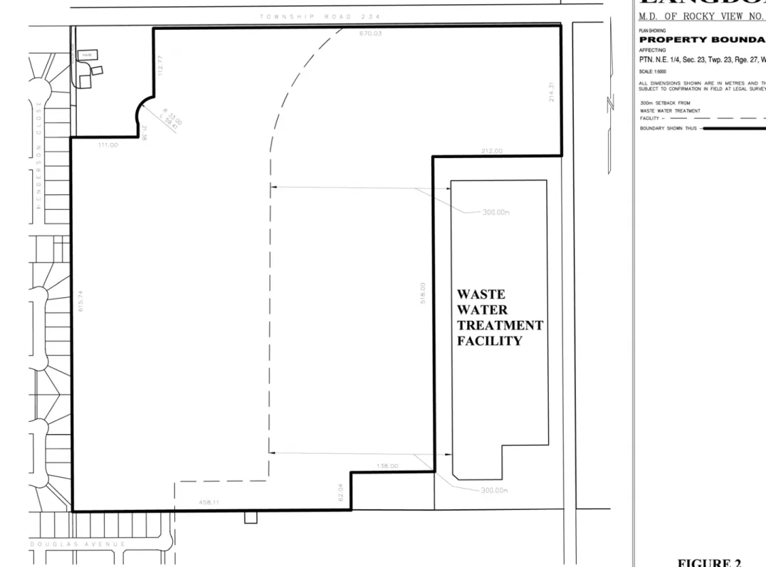
The subject property is bounded by Township Road 234 (Hwy. 560) to the north, by the M.D. of Rocky View’s waste water treatment facility to the east and south, by residential development to the south and west, and by Lot 1A, Block 1, Plan 8710378 to the northwest. See Figure 2 – Property Boundary for the boundaries of the property.
3.4 Current Land Use
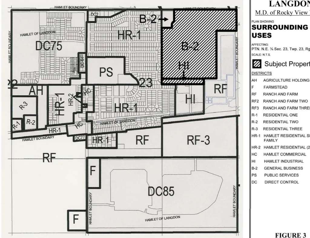
The Planning Area is designated General Business District (B-2) and Hamlet Industrial District (HI) under the M.D. of Rocky View No. 44 Land Use Bylaw. The purpose of the B-2 District is to provide a wide range of business and associated uses which are compatible with each other and do not adversely affect the surrounding land uses. The purpose of the HI District is to provide for indoor or outdoor manufacturing, processing, assembly, distribution service, and repair uses. The above land use districts are shown in Figure 3 – Surrounding Land Uses. The property is currently vacant of buildings and the land is not in use.
3.5 Community Context and Land Use
A variety of land uses surround the subject lands as identified in the M.D. of Rocky View Land
Use Bylaw and as shown in Figure 3 – Surrounding Land Uses:
North
The quarter section directly north of the Planning Area (SE 26-23-27 W4M) is divided into two parcels. The western parcel is designated Ranch and Farm District (RF) and the eastern parcel is designated Ranch and Farm Three District (RF-3). This quarter section lies outside the
boundaries of the Hamlet of Langdon and is currently being used for agricultural purposes. East
Located northeast of the Planning Area is Weed Lake. The storm water drainage from the Hamlet of Langdon and the rural lands to the east enters Weed Lake through a culvert located northeast of the site.
The NW 24-23-27 W4M is located east of the Planning Area and is designated Ranch and Farm District (RF). This property is currently being used for agricultural purposes and is located outside of the Hamlet of Langdon’s boundary. An application for a conceptual scheme and land use redesignation has been filed with the Municipality, which if approved, would see the lands being redesignated General Business District and Direct Control District to allow for business industrial type uses.
To the southeast and within the NE 23-23-27 W4M is land designated Ranch and Farm District (RF). This parcel of land contains the wastewater treatment facility that services the Hamlet of Langdon. This facility is considered a public/quasi-public land use within the Hamlet of
Langdon. Section 7.1.1 of the ASP highlights Alberta Environment regulations that require a 300 metre (1000 feet) buffer be established between the wastewater treatment facility and solid waste transfer site and any residential development or school site.
South
The lands immediately south of the Planning Area are within the Hamlet of Langdon and are designated Hamlet Industrial District (HI). The intended uses for these lands are a business park, industry, and public/quasi-public land uses as outlined in the Hamlet of Langdon and Land Use Bylaw.
Southwest of the Planning Area is property designated Hamlet Residential Single Family District (HR-1). These lands have recently been subdivided into residential lots.
West
The lands immediately west of the Planning Area are designated Hamlet Residential Single Family District (HR-1). Properties in the original sections of the Hamlet are characterized by small lot sizes and more traditional residential dwellings, while properties in the recent 480-home Langdon Crossings subdivision are characterized by large lot sizes, sidewalks and modern housing design.
Northwest
Northwest of the property is a 5.4 acre commercial parcel (Lot 1A, Block 1, Plan 8710378). This parcel is located within the Hamlet of Langdon and is currently designated General Business District B-2. Presently the site is used for the manufacturing of wood cabinets. While the owner has requested that the parcel not be included in the Conceptual Scheme, a shadow plan for this site has been provide, as shown in Figure 11 – Transportation Map to provide a sense of how the parcel could be integrated into the overall conceptual scheme Planning Area.
4.0 Physical Site Features
4.1 Topography
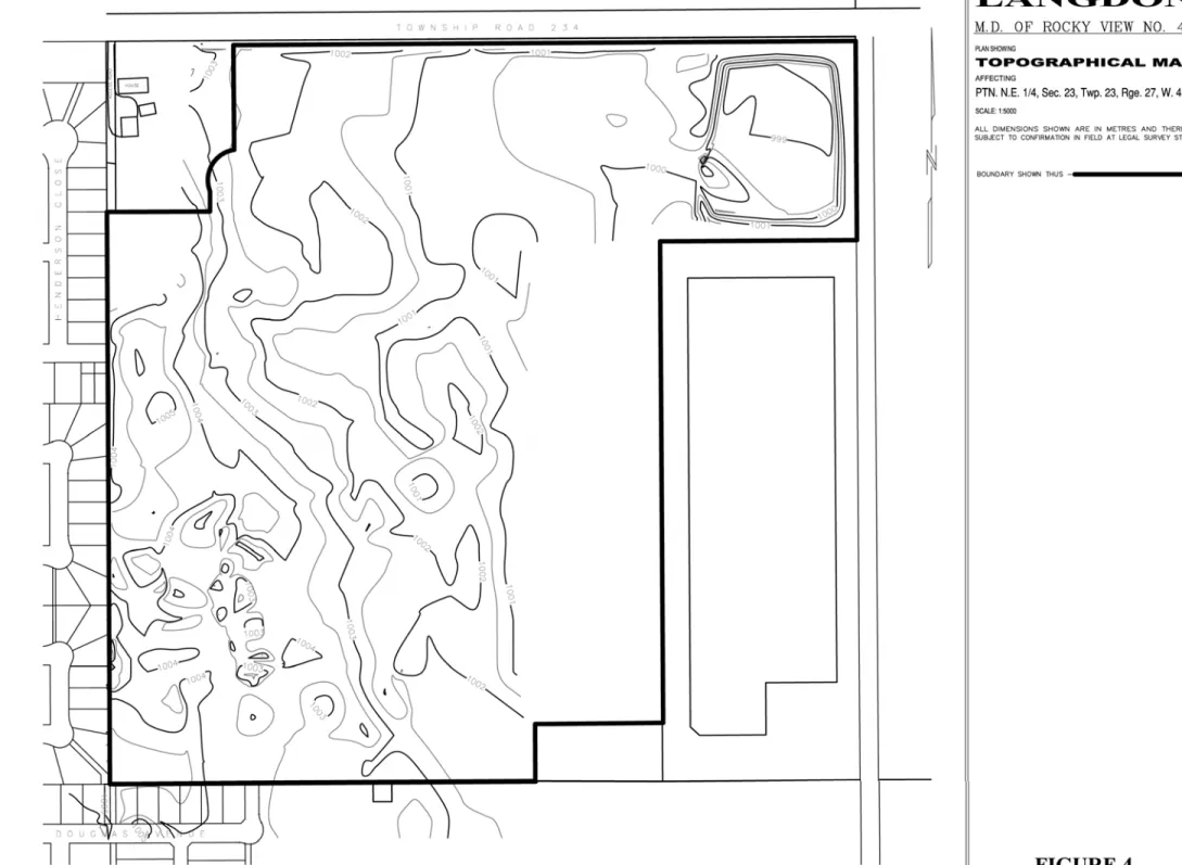
The Planning Area is characterized by a low relief plan and undulating topography resulting from glacial activity. The terrain is declined towards the east with variations in elevation of approximately 6 metres (1005 metres to 999 metres). Figure 4 – Topographical Map presents the major natural topographic features found on the site. Figure 5 – Aerial Photo presents an aerial photo of the subject lands.
4.2 Subsurface Conditions
Soil-Teck Inc. conducted a geotechnical investigation on the subject lands as required by the M.D. of Rocky View’s Land Use Bylaw. This report has been submitted under separate cover. The following is a summary of their findings:
• The topsoil was comprised of black or brown, organic silty clay. The thickness of topsoil varied from 50 mm to 300 mm;
• Beneath the topsoil and of a thickness approximately 1.0 metre was interbedded silt and clayey silt layers. The moisture content of the silt ranged from 9% to 22%. Low areas are generally associated with the higher moisture content;
• Clay till was encountered below a depth of 1 metre. The clay till is characterised by its mixture of gravel, sand, silt, and clay;
• Sulphate tests determined relatively high degree of sulphate concentrations.
4.3 Hydrology
The hydrology of the subject lands are characterised by its poorly draining clay till underlay and its high water table. Water from the grass covered, undeveloped site drains towards the east. The runoff in turn collects in the natural land depressions along the eastern site boundary. The overflow from the depressions drains into Weed Lake via the Langdon Crossing Ditch. The Langdon Crossing Ditch runs along the southern and eastern boundaries of the study area. The southern portion of this ditch is within a 9-metre Utility Right of Way that runs along the southern boundary of the property. The eastern portion of the ditch is located within the wastewater treatment facility property boundaries.
There is currently a joint initiative between the M.D. of Rocky View, Ducks Unlimited Canada, Western Irrigation District, and Alberta Environment to reconstruct Weed Lake into a
functioning wetland. The main body of Weed Lake, which presently is located on the north side of Township Road 234 (Hwy. 560), will extend south from Township Road 234 (Hwy. 560) and east from the subject site. The above information can be confirmed in the Preliminary Storm Drainage Plan produced by Lee Maher Engineering Associates Ltd. and submitted under separate cover.
4.4 Vegetation
Vegetation on the site consists mainly of native prairie grasses. There are no significant plant communities within or in proximity to the subject lands that require special consideration.
4.5 Existing Structures
There are currently no existing structures on the subject lands.
4.6 Environmental Considerations
Soil & Environ. Consulting Inc. conducted an environmental assessment of the subject lands. This report has been submitted under separate cover. The following is a summary of its conclusions:
• From the earliest available records the property has been used for farming, pasturing and grazing only, and would not likely pose a risk in terms of environmental impact towards the development of the property;
• The site should be free of any adverse man-made environmental impacts that would have detrimental effects on the health of the future residents/businesses of the new subdivision; • No hazards requiring attention were detected and therefore no further investigation of the
5.0 Land
Use
The Planning Area is currently designated General Business District (B-2) and Hamlet Industrial District (HI) under the M.D. of Rocky View Land Use Bylaw. Exhibit 3 in Section 6.2 of the
Hamlet of Langdon ASP sets out the future land use scenario for the subject lands which include
residential, school, business park and industrial type uses.
Policy 5.0.1 Land uses within the Conceptual Scheme Planning Area shall conform to the Future Land Use Scenario as established in the Hamlet of Langdon ASP.
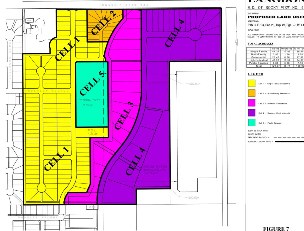
The Conceptual Scheme proposes that the subject lands be redesignated to Direct Control District and divided into five development cells. The five development cells include the following:
• Cell 1 – Single Family Residential • Cell 2 – Multi-Family Residential • Cell 3 – Business Commercial • Cell 4 – Business Light Industrial • Cell 5 – Public Services
The proposed development cells are shown in Figure 7 – Proposed Land Uses and tabulated in Table 1. These proposed uses are consistent with the Future Land Use Scenario of the Hamlet of Langdon ASP.
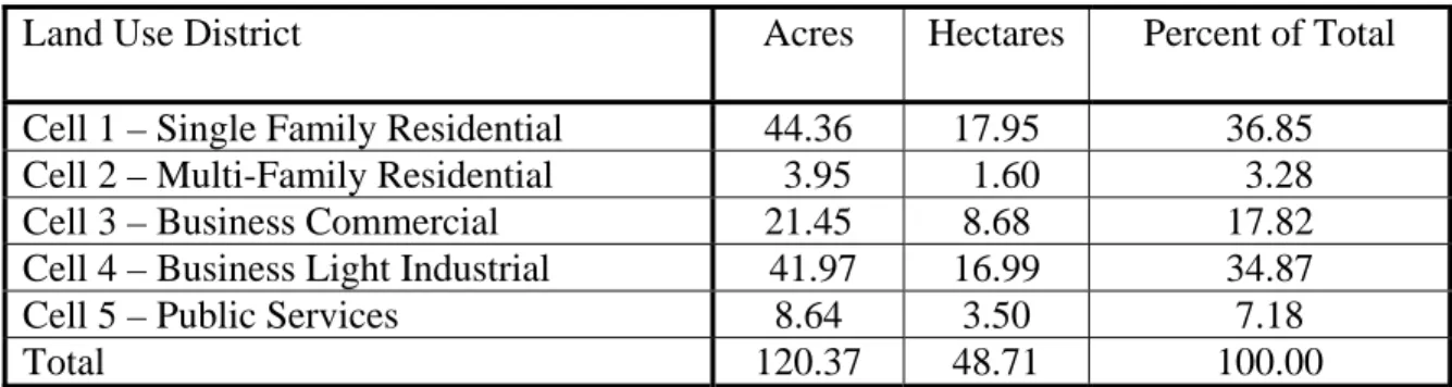
Table 1: Land Use Statistics (Approximate)
Land Use District Acres Hectares Percent of Total
Cell 1 – Single Family Residential 44.36 17.95 36.85 Cell 2 – Multi-Family Residential 3.95 1.60 3.28
Cell 3 – Business Commercial 21.45 8.68 17.82
Cell 4 – Business Light Industrial 41.97 16.99 34.87
Cell 5 – Public Services 8.64 3.50 7.18
Total 120.37 48.71 100.00
5.1 Cell 1 – Single Family Residential
The purpose and intent of Development Cell 1 is to provide for single family residential development with associated open space areas including pathways.
Policy 5.1.1 Lands identified as Development Cell 1 within the Conceptual Scheme Area shall conform to requirements of the Direct Control District and the
Policy 5.1.2 Lands identified as Development Cell 1 within the Conceptual Scheme Area shall conform to the Residential Land UsePolicies as set out in Section 7.2 of the Hamlet of Langdon Area Structure Plan.
5.2 Cell 2 – Multi-family Residential
The purpose and intent of Development Cell 2 is to allow for the development of medium density residential development. The Hamlet of Langdon ASP allows for a maximum of 7% of the overall residential component of a plan area to include medium density residential
development.
Policy 5.2.1 Lands identified as Development Cell 2 within the Conceptual Scheme Area shall conform to requirements of the Direct Control District and the
General Regulations as set forth within the current M.D. of Rocky View
Land Use Bylaw, as amended.
Policy 5.2.2 Lands identified as Development Cell 2 within the Conceptual Scheme Area shall conform to the Residential Land Use policies as set out in Section 7.2 of the Hamlet of Langdon Area Structure Plan.
5.3 Cell 3 – Business Commercial
The purpose and intent of Development Cell 3 is to provide a wide range of commercial business uses (i.e. automotive equipment and vehicle sales, garden centres, health care services, offices, and general industry) which are compatible with each other while recognizing the need to be sensitive to the adjacent land uses to the west.
Policy 5.3.1 Lands identified as Development Cell 3 within the Conceptual Scheme Area shall conform to requirements of the Direct Control District and the
General Regulations as set forth within the current M.D. of Rocky View
Land Use Bylaw, as amended.
Policy 5.3.2 Lands identified as Development Cell 3 within the Conceptual Scheme Area shall conform to the Business Park Polices as set out in Section 7.3 of the Hamlet of Langdon Area Structure Plan.
5.4 Cell 4 – Business Light Industrial
The purpose and intent of Development Cell 4 is to provide for a range of business/light
industrial uses which are compatible with each other and do not adversely affect the surrounding land uses.
Policy 5.4.2 Lands identified as Development Cell 4 within the Conceptual Scheme Area shall conform to the Business Park Polices as set out in Section 7.3 of the Hamlet of Langdon Area Structure Plan.
5.5 Cell 5 – Public Services
The purpose and intent of Development Cell 5 is to accommodate a future public elementary school site.
Policy 5.5.1 Lands identified as Development Cell 5 within the Conceptual Scheme Area shall conform to the Direct Control District and the General
Regulations as set forth within the current M.D. of Rocky View Land Use
Bylaw, as amended.
Policy 5.5.2 Lands identified as Development Cell 5 within the Conceptual Scheme Area shall conform to the Open Space, Park, and Municipal/School
Reserve Policies as set out in Section 7.4 of the Hamlet of Langdon Area
6.0 Subdivision and Development Sequence
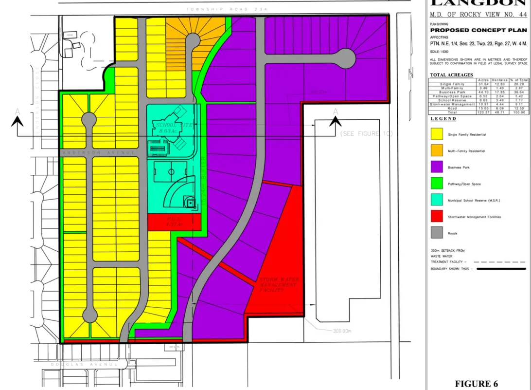
The subject lands will be subdivided to accommodate a residential community, a business park, a school site, pathways, and a stormwater management facility. The subdivision of the subject property will be undertaken in five phases. The proposed land uses for the subject lands is shown in Figure 6 – Proposed Concept Plan and tabulated in Table 2.
Policy 6.0.1 Lands within the Conceptual Scheme Planning Area shall be developed as generally shown in Figure 6 – Proposed Concept Plan and as generally tabulated in Table 2.
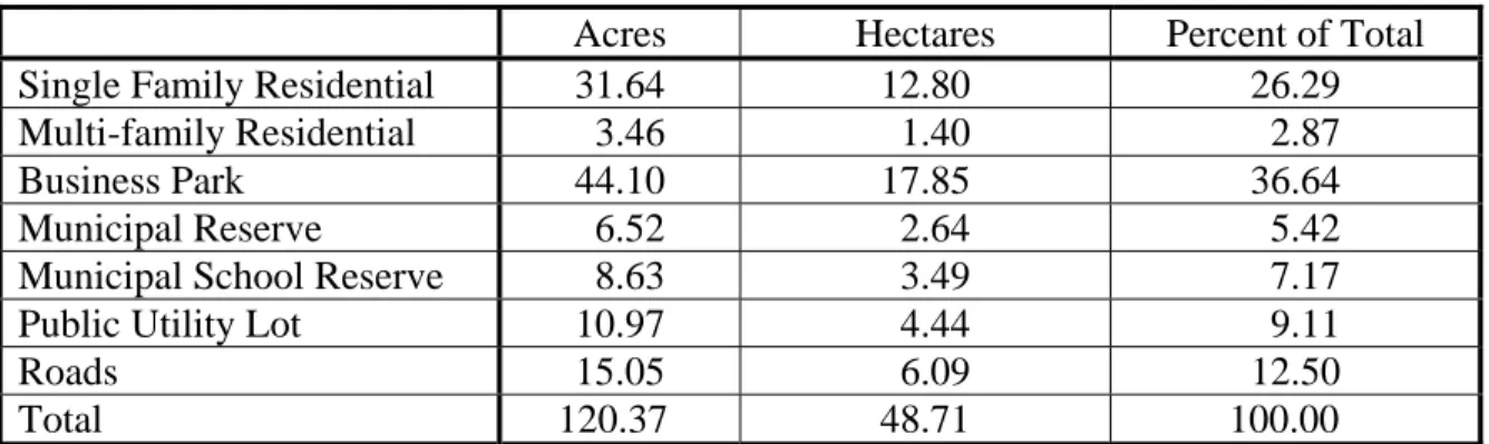
Table 2: Subdivision Statistics (Approximate)
Acres Hectares Percent of Total
Single Family Residential 31.64 12.80 26.29
Multi-family Residential 3.46 1.40 2.87
Business Park 44.10 17.85 36.64
Municipal Reserve 6.52 2.64 5.42
Municipal School Reserve 8.63 3.49 7.17
Public Utility Lot 10.97 4.44 9.11
Roads 15.05 6.09 12.50
Total 120.37 48.71 100.00
6.1 Single Family Residential
The single family residential component of the proposed development is to be composed of single detached dwellings and will occupy approximately 12.80 hectares (31.64 acres) of the gross area. Approximately 114 units are proposed, resulting in a HR-1 residential density of approximately 0.95 units/acre. The Hamlet of Langdon ASP allows for a density of 4.0
units/acre. As per the Hamlet of Langdon ASP, the minimum lot size will be 0.20 acres, with the overall average lot size being no less than 0.25 acres.
It should be noted that, where applicable, all single family residential dwellings will be setback 300 metres from the existing wastewater treatment facility & the solid waste transfer site, as per Alberta Environment Regulations.
Policy 6.1.1 Single family residential lands subdivided within the Conceptual Scheme Planning Area shall conform to the minimum requirements for parcel size, width, and front, side and rear setbacks of the Direct Control District and
the General Regulations as set forth within the M.D. of Rocky View’s
Policy 6.1.3 Single family residential land uses shall be setback 300 metres (1,000 feet) from the existing wastewater treatment facility and solid waste transfer site as per Alberta Environment regulations and as stated in Section 7.1 of
the Hamlet of Langdon Area Structure Plan.
6.2 Multi Family Residential
The multi-family residential component of the proposed development is to be composed of semi-detached dwellings. The multi-family residential component will occupy approximately 1.40 hectares (3.46 acres) of the Planning Area, which is approximately 6.4% of the overall
residential area. The Hamlet of Langdon ASP allows for no more than 7% of medium density development throughout the subject lands. The Hamlet of Langdon ASP also states that medium density residential shall not exceed 10 dwelling units per gross acre. With approximately 20 units being proposed, with two units per lot, the resulting density for multi-family residential development would be approximately 0.17 units/acre.
While Figure 6 – Proposed Concept Plan identifies a portion of the subject lands as multi-family residential, the Municipality, may consider allowing single multi-family residential
development to occur, without requiring an amendment to the Conceptual Scheme, if after 5 years from the adoption of this Conceptual Scheme by Council, the Developer can demonstrate to the Municipality that multi-family residential development is not a feasible form of
development for this area.
It should be noted that, where applicable, all multi-family residential dwellings will be setback 300 metres from the existing wastewater treatment facility & the solid waste transfer site, as per Alberta Environment Regulations.
Policy 6.2.1 Multi-family residential lands subdivided within the Conceptual Scheme Planning Area shall conform to the minimum requirements for parcel size, width, and front, side and rear setbacks of the Direct Control District and
the General Regulations as set forth within the M.D. of Rocky View’s
Land Use Bylaw, as amended.
Policy 6.2.2 Multi-family residential lands subdivided within the Conceptual Scheme Planning Area shall conform to the Residential Land Use policies in Section 7.2 of the Hamlet of Langdon Area Structure Plan.
Policy 6.2.3 Lands identified on Figure 6 – Proposed Concept Plan, as Multi-family Residential may revert to Single Family Residential if after 5 years from the adoption of this Conceptual Scheme by Council, the Developer can demonstrate to the Municipality that multi-family residential development is not a feasible form of development.
Policy 6.2.4 Multi-family residential land uses shall be setback 300 metres (1,000 feet) from the existing wastewater treatment facility and solid waste transfer site as per Alberta Environment regulations and as stated in Section 7.1 of
6.3 Business Park
The business park component of the proposed development is intended to provide a range of commercial and industrial employment opportunities for the Hamlet and surrounding
community. The business park will occupy approximately 17.85 hectares (44.10 acres) of the Planning Area. Approximately 40 lots are to be created in a variety of sizes. As per Policy 7.3.3.4 of the Hamlet of Landon ASP, the business park will be included within a Direct Control District and will have consideration for Policy 7.3.3.2 of the Hamlet of Langdon ASP with respect to inappropriate uses.
As required by the Hamlet of Langdon ASP, a 15.24m (50 ft) landscaped buffer/walkway shall be constructed between the business park and all residential and school uses to the west. The Developer will be required to construct the buffer strip during the business park phasing of the development. Maintenance of the buffer/walkway will be the responsibility of the Lot Owners’ Association for the commercial component.
The business park will be subject to the Performance Standards and Development Guidelines as adopted by Council and set out in the Hamlet of Langdon ASP and M.D. of Rocky View Land Use Bylaw, as amended.
Policy 6.3.1 Business park lands subdivided within the Conceptual Scheme Planning Area shall conform to the requirements for parcel size, width, and front, side and rear setbacks of the Direct Control District and the General
Regulations as set forth within the M.D. of Rocky View’s Land Use
Bylaw, as amended.
Policy 6.3.2 Business park lands subdivided within the Conceptual Scheme Planning Area shall conform to the Business Park policies in Section 7.3.3 and the
Industrial policies in Section 7.3.4 of the Hamlet of Langdon Area
Structure Plan.
Policy 6.3.3 A buffer of no less than 15.24m (50 ft) shall be provided between the business park and residential and school uses to the west.
Policy 6.3.4 The business park shall be subject to the Performance Standards and Development Guidelines of the Hamlet of Langdon ASP and M.D. of Rocky View Land Use Bylaw.
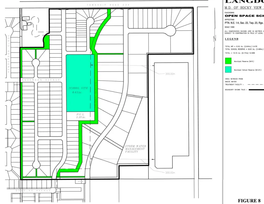
6.4 Municipal Reserve & Municipal School Reserve
The Municipal Reserve (MR) and Municipal School Reserve (MSR) components of the proposed development will occupy approximately 6.13 hectares (15.15 acres) of the Planning Area. The Municipal School Reserve will provide for a future public elementary school site, while the Municipal Reserve will be comprised of a system of pathways and open spaces. The plan provides for 12.6% dedication toward Municipal and School Reserves, resulting in 2.6% over and above the 10% required under the Municipal Government Act.
Final determination of the provision, location and details of the MR and MSR within the Conceptual Scheme Area shall be determined at time of subdivision.
Policy 6.4.1 Municipal School Reserve shall be dedicated in accordance with Figure 8 – Open Space Scheme.
Policy 6.4.2 Municipal Reserve shall be dedicated in accordance with Figure 8 – Open Space Scheme.
Municipal School Reserve
In consultation with the Rocky View School Division, a 3.49 hectares (8.63 Acres) Municipal School Reserve parcel has been identified within the Planning Area for the purposes of a future public elementary school site. The subject parcel is situated at the eastern terminus of Anderson Avenue and is centrally located within the Planning Area.
Policy 6.4.3 Municipal School Reserve lands identified within the Conceptual Scheme Area shall generally conform to the requirements of the Rocky View School Division and the M.D. of Rocky View.
Policy 6.4.4 Municipal School Reserve lands identified within the Conceptual Scheme Area shall conform to the Open Space, Park and Municipal School
Reserve Policies in Section 7.5 of the Hamlet of Langdon Area Structure
Plan.
Policy 6.4.5 The school building shall be setback 300 metres (1,000 feet) from the existing wastewater treatment facility and solid waste transfer site as per Alberta Environment regulations and as stated in Section 7.1 of the
Hamlet of Langdon Area Structure Plan.
Pathway/Open Space
The pathway/open space component of the proposed development will consist of a system of pathways and open spaces and will occupy approximately 2.64 hectares (6.52 acres) of the Planning Area as shown in Figure 8 – Open Space Scheme. Four major pathways are shown on the plan and are designed to work within the Conceptual Scheme Area in addition to linking the existing sidewalk and pathway system to the rest of the Hamlet:
• A 9.00 metre wide linear pathway shall be dedicated and constructed by the Developer, which shall run north-south along the western boundary of the property. This pathway shall provide pathway access to the existing residential development to the south and west. The pathway will act as a buffer between the proposed residential component and the existing residential development to the west and the existing general business development to the northwest.
•
• A 15.24 metre wide linear pathway shall be dedicated and constructed by the Developer which shall run north-south through the centre of the quarter section. The pathway shall provide pathway access to the proposed school, residences, and business park. The pathway shall link with the pathway to the south by way of a crossing, to be constructed at the cost of the Developer, over the east-west Langdon Crossing stormwater drainage ditch. The linear pathway will provide a buffer between the residential area and the school site and business park, as required in Section 7.3.3.3 of the Hamlet of Langdon ASP. The pathway shall contain sufficient landscaping, berming, and fencing to screen the business park future residential dwelling units and the proposed school.
• A 5.00 metre wide linear pathway shall be dedicated and constructed by the Developer which shall run east-west along the southern boundary of the property parallel to the existing drainage ditch. The pathway shall provide pathway access from the existing and proposed residential areas to the proposed business park and school site.
• A 5.00 metre wide linear pathway shall be dedicated and constructed by the Developer which shall run east-west from the northeast corner of the Municipal School Reserve to the business park. The pathway shall provide pathway access from the residential area to the proposed business park.
Policy 6.4.6 Pathway/open space lands identified within the Conceptual Scheme Area shall conform to the Open Space, Park and Municipal / School Reserve
polices in Section 7.5 of the Hamlet of Langdon Area Structure Plan. Policy 6.4.7 Construction of the pathway/open space shall be the responsibility of the
Developer, to the satisfaction of the Municipality, while the maintenance of the pathway/open space will be the responsibility of a Lot Owners’ Association formed from amongst the owners of each of the individual lots within the subject lands.
6.5 Stormwater Management Facilities
Stormwater management facilities will be constructed by the Developer on the subject lands and function as part of the overall stormwater management system. The stormwater management facilities component of the proposed development will occupy approximately 4.44 hectares (10.97 acres) of the Planning Area. The following is a summary of the stormwater management facilities which will be contained within PULs:
• The collector drainage ditch that connects the dry pond to the stormwater management facility;
• Access to the stormwater management facility from the business park;
• The stormwater drainage conveyance along the eastern boundary of the Conceptual Scheme Area;
• The section of the Langdon Crossing stormwater drainage ditch that runs west to east along the southern boundary of the property.
• The stormwater management facility situated in the southeast corner of the subject lands required to service the proposed development.
Policy 6.5.1 Stormwater management facilities, as identified on Figure 6 – Proposed Concept Plan, shall be for the purpose of the stormwater management.
Policy 6.5.2 The Developer is to construct all required stormwater management facilities to the satisfaction of the Municipality
6.6 Phasing
The Plan Area will be developed in five phases as shown in Figure 9 – Phasing Map.
Development will commence with residential development to the northwest with the final phase being that of the business park to the east. The development sequence was chosen to take advantage of existing infrastructure within the Hamlet of Langdon. While the phasing of development within the Planning Area is matched to a logical progression of servicing and transportation, applications for subdivision approval may proceed out of sequence, provided it can be demonstrated that the required infrastructure is in place and/or available to sustain the proposed subdivision phase. No amendment to the Conceptual Scheme would be required phasing out of sequence.
It should be noted that construction traffic will not be permitted to travel through the existing Hamlet of Langdon but will be required to access the Plan Area via Township Road 234 (Hwy. 560).
Policy 6.6.1 The Plan Area shall be developed in sequence with the Phasing Map shown in Figure 9 – Phasing Map.
Policy 6.6.2 Subdivision may proceed out of sequence, without amendment to the Conceptual Scheme, provided the Applicant can demonstrate that the required infrastructure is in place and/or available to sustain the proposed
Policy 6.6.3 Construction traffic shall not be permitted to travel through the existing Hamlet of Langdon, and specifically by way of Anderson Avenue or Douglas Avenue to access the Plan Area.
Policy 6.6.4 The Developer shall prepare a Construction Management Plan in support of each phase of development at time of subdivision, to the satisfaction of the Municipality.
7.0 Urban
Design
7.1 Architectural & Massing Scheme
The following list of policies is intended to establish a built form that creates both a sense of place and a sense of community. In terms of a sense of place, the built form should be comfortable, have an identifiable character, and be sensitive to the history of the Hamlet of Langdon while incorporating new trends and ideas. With respect to a sense of community, the development should be a place where residents realize membership, belonging, interaction, fulfillment of needs, and a shared emotional connection. Figure 10 – Section AA illustrates a cross section of the proposed development demonstrating the typical massing of the site. General
Policy 7.1.1 Gradual, versus abrupt transitions in building height and massing shall be encouraged. This may be accomplished by adjacent buildings including minimal variation in height (e.g. ½ storey), incorporating building elements of similar sizes and shapes, breaking up the facade into smaller architectural components, partially concealing an upper storey in the slope of the roof, or increasing their mass at the rear of the lot versus the front. Policy 7.1.2 Streetscapes should be defined and framed to establish a comfortable
pedestrian environment. This may be accomplished by providing minimal and consistent building setbacks from streets, by situating buildings parallel to the street, and by planting trees and shrubs adjacent to the road Right-of-Ways.
Policy 7.1.3 The planting of coniferous trees on the north side of buildings and the planting deciduous trees on the south side of buildings shall be encouraged to enhance energy conservation.
Policy 7.1.4 Buildings shall be designed with their own architectural character, shall compliment the built heritage of Langdon, should provide for variety and interest, and shall be of a high quality architecture and construction. Policy 7.1.5 Fencing along pathways should be chain link, visually permeable, and no
higher than 4 feet to allow for informal surveillance from adjacent properties.
Residential
Policy 7.1.6 New residential dwellings should share basic massing and overall heights and be of a scale similar to existing residential dwellings within the Hamlet of Langdon.
Policy 7.1.7 Front patios/porches are encouraged for residential dwellings to promote neighbourly interaction and to enhance front yard aesthetics.
Policy 7.1.8 Garage doors should be recessed from the front façade of new residential dwellings to reduce their prominence and to avoid a monotonous garage door streetscape.
Business Park
Policy 7.1.9 The architecture, height, and massing of business park buildings should consider and respect the character of surrounding development.
Policy 7.1.10 Parking for the business park should be located at the side or rear of buildings to enhance the aesthetics of the business park.
7.2 Crime Prevention Through Environmental Design
The overall physical design of the proposed development helps to discourage crime and to encourage legitimate uses of the environment. For example, the residential, school, and business park uses provide a diversity of activities throughout the day and night, which creates the
appearance of uninterrupted surveillance. The front and flanking alignment of buildings along the internal roads provide opportunities for self-policing. Finally, the proposed street and pathway lighting will provide additional visibility and a sense security throughout the Planning Area.
While considering the above, it is important to highlight areas where there are opportunities to enhance safety and security within the Conceptual Scheme Area. Highlighted areas include the pathways, the school site, and the business park. Safety and security within these areas can be enhanced by introducing design elements that increase surveillance, eliminate places of concealment, limit visual obstacles, and include appropriate lighting.
Pathways
Policy 7.2.1 Fencing along pathways shall be chain link, visually permeable, and no higher than 4 feet to allow for informal surveillance from adjacent properties.
Policy 7.2.2 Shrubbery within the pathways shall be limited to a maximum height of 3 feet and trees to a minimum height of 6 feet at the lowest branches along pathways.
Lighting
Policy 7.2.3 Lighting shall be encouraged throughout the business park as there is limited evening and night activity within this area.
7.3 Landscape Guidelines
A Landscape Plan will be required at the time of subdivision for each phase of development. The Landscape Plan will include provisions for landscaping and screening as per Section 26 of the
Land Use Bylaw and the applicable Direct Control Bylaw pertaining to the business park.
Implementation of the Landscape Plan will be addressed through the Development Agreement of which the Landscape Plan will be included.
Policy 7.3.1 The Landscape Plan shall be in accordance with the M.D. of Rocky View Land Use Bylaw, as amended.
Policy 7.3.2 The Landscape Plan, as it applies to Phase 5 – Business Park, shall be in accordance with the applicable Direct Control Bylaw and the M.D. of Rocky View Land Use Bylaw, as amended.
Policy 7.3.3 A Landscape Plan is to be submitted for each phase of subdivision approval to the satisfaction of the Municipality.
Policy 7.3.4 Implementation of the Landscape Plan is to be through the development agreement at the time of subdivision approval for each applicable phase.
8.0 Servicing
8.1 Transportation
External RoadsAccess to the site will be provided by the existing and future road network. This network includes the following local and collector roads:
• Township Road 234 (Hwy. 560), Existing Collector: Extends east from Center Street (formerly Highway 797) and has an estimated daily traffic volume of 2,100 vpd at its approach to Center Street. The classification of the Township Road 234 (Hwy. 560) indicates that this road can accommodate up to 2,500 vpd.
• Anderson Avenue, Existing Collector: Extends east from Center Street and has a posted speed limit of 40 km/h. The current daily traffic volumes along Anderson Avenue, east and west of Center Street are approximately 1,100 vpd and 2,300 vpd respectively. East of Wilson Road, the estimated existing daily volumes decrease to approximately 680 vpd. The classification of Anderson Avenue indicates that it can accommodate up to 2,500 vpd.
• Douglas Avenue, Existing Collector/Local: Extends east from 4th Street N.E. and turns north to connect to the Conceptual Scheme Area. The east-west section of this road is a collectorstandard, while the north-south is a localstandard. According the municipality, the north-south segment of the road will be upgraded to a collector standard. The
collectorclassification of Douglas Avenue indicates that it can accommodate up to 2,500 vpd.
• Future Business Collector, Future Collector: To extend south from the site to serve the business park and industrials areas proposed in the Hamlet of Langdon ASP. This collector road is identified in Exhibit 6 of the Hamlet of Langdon ASP.
Internal Roads
The Conceptual Scheme Area will be serviced by a modified grid pattern of roads as shown in Figure 11 – Transportation Map. The proposed road network will include:
• North-South Residential Collector. This road is to serve the residential area and will provide a linkage from Township Road 234 (Hwy. 560) to the north to Douglas Avenue to the south.
• East-West Residential Collector. This road is to serve the residential area and is to extend Anderson Avenue to the proposed North-South Residential Collector.
• Local roads. Local roads will branch off from the residential collectors to service the remaining residential areas of the proposed development.
• Road right-of-way. A road right-of-way will be dedicated, at the time of subdivision, to provide access to Parcel 8710378, Block 1, Lot 1A internally. The right-of-way is to allow for any future development of the existing general business parcel to the northwest. • North-South Business Collector. A business collector road will serve the business park
area. The future business collector is identified under Section 7.6.2.12 of the Hamlet of Langdon ASP and shown on Exhibit 6 of the ASP. This north-south road will connect to Township Road 234 (Hwy. 560) to the north and to the hamlet industrial area proposed to the south. As required by the ASP, the North-South Business Collector will not have direct access to adjacent residential areas nor Railway Avenue.
Policy 8.1.1 The street system shall adhere to the Street System policies found in Section 7.6 of the Hamlet of Langdon Area Structure Plan.
Policy 8.1.2 The internal street pattern shall conform to the transportation plan shown in Figure 11 – Transportation Map.
Policy 8.1.3 A road right-of-way shall be dedicated, at the time of subdivision, to provide access to Parcel 8710378, Block 1, Lot 1A internally.
Policy 8.1.4 The North-South Business Collector servicing the business park shall not have direct access to the residential area.
Policy 8.1.5 Notwithstanding Policy 8.1.7, Development Permits may be issued for show homes before a Development Agreement has been entered into and before the required road system has been constructed and received a Construction Completion Certificate.
Sidewalks
In order to provide a safe and comfortable pedestrian environment a system of sidewalks should be established and constructed within the development. The Developer will be responsible for the construction of any and all sidewalks throughout the Planning Area. Maintenance of the sidewalks shall be the responsibility of the Lot Owners’ Association.
Policy 8.1.6 All residential collector roads shall include sidewalks on both sides of the road.
Policy 8.1.9 The Developer is responsible for the construction of any and all sidewalks. Maintenance of the sidewalks is the responsibility of the Lot Owners’ Association.
Policy 8.1.10 The sidewalk construction details shall be as per the standards specified by the Municipality.
Crosswalks
The Rocky View School Division has indicated that a Public Elementary school may be
established on the Municipal School Reserve site. During school days, it is expected that children will be crossing Anderson Avenue to go to and from the school. To augment the safety of those crossing Anderson Avenue, the installation of a crosswalk should be considered at the
intersection of Anderson Avenue and the North-South Residential Collector.
Policy 8.1.11 The installation of a crosswalk should be considered for the intersection of Anderson Avenue and the North-South Residential Collector to the
satisfaction of the Municipality. Traffic Impact Assessment
A Traffic Impact Assessment (TIA) for the proposed development was prepared in accordance to Section 7.2.8 and Section 7.6.2.13 of the Hamlet of Langdon ASP. This report has been
submitted under separate cover. Each phase of subdivision will be required to provide an update/addendum to the approved TIA to assist the Municipality in determining the impacts of the proposed development on the existing infrastructure in and around the Planning Area. The recommendations of the TIA, as it pertains to the subject site, are summarized below:
• Configure the new Township Road 234/North-South Residential Collector intersection as follows:
o 1 shared eastbound through/right turn lane o 1 shared westbound through/left turn lane o 1 shared northbound left/right turn lane o Northbound stop control
• Configure the new Anderson Avenue/North-South Residential Collector intersection as follows:
o 1 shared eastbound left/right turn lane o 1 shared northbound through/left turn lane o 1 shared southbound through/right turn lane
• Configure the new Township Road 234/North-South Business Collector intersection as follows:
o 1 dedicated eastbound through lane o 1 dedicated eastbound right turn lane o 1 shared westbound left/through lane o 1 dedicated northbound left turn lane o 1 dedicated northbound right turn lane o Northbound stop control
• Use a Hamlet Collector Road standard for the planned North-South Residential Collector Road.
• Use a UCU 50 SAR road standard for the planned North-South Business Collector Road. • Install sidewalks along the North-South Residential Collector Road and the planned local
roads within the development area to encourage and facilitate pedestrian travel.
• Install a pedestrian crosswalk at the south approach of the Anderson Avenue/North-South Residential Collector Road intersection with zebra style paint markings and side mounted signs (RA-3 and RA-1). Also, consider installing advance crosswalk warning signs (WC-16).
• Consider using on site (within the school site) loop roads to accommodate school buses to prevent potential bus/traffic and student traffic conflicts.
• If parent drop off areas are planned for the school site, consider using on site (within the school site) loop roads for these areas to help prevent traffic congestion on area roads. Policy 8.1.15 An update to the approved Traffic Impact Assessment will be required at
each phase of subdivision approval to the satisfaction of the Municipality. Policy 8.1.16 The recommendations identified in the Traffic Impact Assessment,
pertaining specifically to the Conceptual Scheme Area and the area contiguous to it, shall be implemented by the Developer and to the satisfaction of the Municipality at the time of subdivision.
8.2 Water Supply
Water is to be supplied to the subject lands from an existing piped water system. Langdon
Waterworks Ltd. will be the supplier and has confirmed that a sufficient water supply is available to service the proposed development in its entirety (see Appendix I). The water servicing
Policy 8.2.1 Water will be supplied to the proposed development by Langdon Water Works Ltd. Their conditions for supplying the water will be met prior to registration of each phase of subdivision.
Policy 8.2.2 All water lines and services shall be constructed to the satisfaction of the Municipality and in accordance with Langdon Waterworks Ltd. design requirements at the time of subdivision.
Policy 8.2.3 Water tie-ins shall be provided to the property line of the Municipal School Reserve to a point specified by the Rocky View School Division.
8.3 Sanitary Sewage Disposal
Collected sewage will be disposed of through gravity flow mains and pumped by a lift station into the municipal wastewater treatment facilities servicing the Hamlet of Langdon. The sanitary servicing proposal is shown in Figure 12 – Servicing Plan.
Policy 8.3.1 All sanitary sewer lines and services shall be constructed in accordance with AENV’s standards to the satisfaction of the Municipality.
Policy 8.3.2 Sewer tie-ins shall be provided to the property line of the Municipal School Reserve to a point specified by the Rocky View School Division.
8.4 Stormwater Management
A Preliminary Storm Drainage Plan for Langdon East has been produced by Lee Maher
Engineering Associates Ltd. This report has been submitted under separate cover. The proposed stormwater management system is summarized below:
• The runoff from the entire study area (excluding the Langdon Crossing Ditch ROW) will be directed to a stormwater management facility (dry/wet pond) located in the naturally low area in the east central location bordering the sewage lagoon;
• The discharge from the stormwater management facility will be driven by gravity and conveyed approximately 460 metres to the Langdon Ditch and subsequently into Weed Lake. The conveyance will be located within a Public Utility Lot (PUL) located along the eastern boundary of the property as described above in Section 6.5;
• The proposed stormwater management facility will contain a permanent water section required to enhance the water quality and reduce sediments before the discharge to Weed Lake;
• The school site will discharge to the main detention facility through its own dry pond; Policy 8.4.1 The stormwater management system shall be designed and constructed to
serve the entire Plan Area, including reserve lands.
Policy 8.4.2 All stormwater management services will be provided to the satisfaction of the Municipality, Alberta Environment, and the Weed Lake Design Committee.
Policy 8.4.3 The stormwater management facility shall exceed the AENV Guidelines for wet ponds and shall conform to the M.D. of Rocky View’s Servicing Standards for Subdivisions.
8.5 Garbage Disposal
Lot owners will be responsible for their own garbage disposal. The M.D. of Rocky View has a waste management transfer site located in east Langdon, south of the subject lands. This transfer site has sufficient capacity to service the proposed development.
Policy 8.5.1 Lot owners will be responsible for the disposal of their own garbage at the M.D. of Rocky View waste transfer site.
8.6 Light Standards
Light standards will be established along all roads and pathways in order to enhance safety and security within the Conceptual Scheme Area. The light standards will be installed by the Developer to the satisfaction of the Municipality. When locating the lighting infrastructure, the Developer shall have consideration for the minimizing light pollution onto adjacent properties. Langdon Waterworks Ltd. will own and maintain the light standards as confirmed in Appendix II. The invoicing for usage and maintenance will be undertaken by Langdon Waterworks Ltd.
Policy 8.6.1 The Developer is to install lighting along all roads and pathways within the Planning Area, while having consideration for any impact on adjacent properties with respect to potential light pollution.
Policy 8.6.2 Light standards shall be owned and maintained by Langdon Waterworks Ltd. Invoicing for usage and maintenance shall be undertaken by Langdon Waterworks Ltd.
8.7 Private Utilities
Policy 8.7.1 Private utilities and appropriate easements and UROW’s shall be provided to each proposed lot by the Developer to the satisfaction of the
Municipality.
Policy 8.7.2 Private utilities tie-ins shall be provided to the property line of the
Municipal School Reserve to a point specified by the Rocky View School Division.
9.0 Emergency Services
Policy 9.0.1 Each lot will be clearly marked with a distinct lot number sign to enable prompt recognition of individual residences by emergency services. Policy 9.0.2 All development shall be connected to the 911 emergency service.
9.1 Fire
The Chestermere and Langdon Fire Departments will provide fire protection services to the Conceptual Scheme Area. Hydrants will be installed on the distribution system and sized to enable the conveyance of adequate water for firefighting purposes as specified by the Langdon Waterworks Ltd.
Policy 9.1.1 All fire protection services shall be constructed to the satisfaction of the Municipality and in conformance with Langdon Waterworks Ltd.’s current standards at the time of subdivision.
10.0 Implementation
The Conceptual Scheme Area has been designed to be compatible with surrounding land uses including the Hamlet of Langdon, and to be consistent with the community vision and
development requirements of the Hamlet of Langdon ASP. Subdivision and development consistent with the policies of this Conceptual Scheme will maximize the development potential of the Planning Area. Subdivision of the Conceptual Scheme Area will be implemented through conditions of subdivision approval by the M.D. of Rocky View.
Policy 10.0.1 The M.D. of Rocky View No. 44 shall implement this Conceptual Scheme through the redesignation, subdivision, and development approval process.