Developing a Quick Seismic Risk Assessment Model
(QSRA) for Intercity Road Systems :A case study, IRAN
M. Firoozi Nezamabadi
Department of Civil Engineering, Faculty of Engineering, Islamic Azad University, South Tehran Branch, Iran
F. Yaghoobi Vayeghan
Department of Risk and Crisis Management, Building and Housing Research Centre, Iran Islamic Azad University (IAU), Tehran, Iran
SUMMARY:
The intercity road systems are of essential use for rescue and relief, aid delivery, temporary settlement and reconstruction purposes in the aftermath of major earthquakes. Therefore, seismic risk evaluation and reduction for these systems is of very great importance, especially for those countries, such as Iran, which do not have enough equipment and infrastructures and are suffering from lack of widely spread reliable transportation networks. In this paper a methodology for quick seismic risk assessment (QSRA) of intercity road systems has been explained and its implementation for roads in Iran has been presented. It can be stated that the proposed methodology is new and no similar methodology has been used by other countries so for. At first, seismic risk has been defined and the involved parameters have been described. Then some of the most important researches in this field have been presented and their outcomes have been discussed. Secondly, the scenario earthquakes based on time of occurrence, which is very important in earthquake risk engineering for intercity road systems, have been introduced. In the next part of the paper, all parameters involved in QSRA methodology and their weight factors have been identified and then the formulation of QSRA has been developed. Finally, the proposed methodology has been implemented in intercity road systems of Iran and Iranian provinces have been prioritized accordingly. This type of prioritization could be very useful for transportation decision makers in Iran and similar countries, especially developing ones, to plan for reducing seismic risk and budget assignments.
Keywords: quick seismic risk assessment, intercity road system, Iran
1. INTRODUCTION
Despite the fact that the roads connecting Bam and Bravat to the centre of province was not significantly damaged in the earthquake happened in 2003, the traffic was disrupted because of the high level of rescue in operation, using this connection road. This was additional to other types of transportation systems, like airway and railroad, which were fully in use. The reason was simply, the roads were not designed for such heavy traffics. The inefficiency of such rural roads has been observed even after the earthquake happed in the previous year in Avaj (Changureh). After that earthquake, rescue operations were done using the only rural road, which was not designed for transportations of heavy Lorries and Trucks [Firoozi et al., 2011].
It has also been observed in other catastrophic earthquakes like Manjil-Roodbar (1990), Northridge, USA (1994), Kobeh, Japan (1995), Ezmith, Turkey (1999), Chi Chi, Taiwan (1999), where lifelines, including urban and rural roads, were seriously damaged in a way that some heavy traffics were made as a result [NGDC, 2006].
There have been done valuable researches about the assessment and risk managements by the one author of this paper [Yaghoobi et al., 2006], Hosseini [Hosseini et al., 2000], Shinozuka [Shinozuka et al., 2000], Mayet [Mayet et al., 2002], Barbhaharan [Barbhaharan et al., 2001], Pellissier [Pellissier et al., 2002], Basoz [Basoz et al., 1996, 1997 and 1998] and Kiremidjian [Kiremidjian et al., 2002], as some examples.
using an index called “EDRI: Earthquake Disaster Risk Index”, in a report has been prepared for the Blume Earthquake Engineering Center (USA) in 1997. The key factors in EDRI are hazard (H), Exposure (E), vulnerability (V), external context (C) and emergency response and recovery planning (R), which combine with a linear formula to generate EDRI as follows,
R
w
C
w
V
w
E
w
H
w
EDRI
H
E
v
C
R (3.1)Where: W's are the weights for different variables. Each variable is generated by adding all subgroup factors (XH), with corresponding weights (wH). For example, H is generated using the following formula, H7 H7 H6 H6 H5 H5 H4 H4 H3 H3 H2 H2 H1 H1
X
w
X
w
X
w
X
w
X
w
X
w
X
w
H
(3.1) Davidson has also evaluated the risk for 10 large cities of the world by calculating the introduced risk assessment index.In this paper, we introduce a quick, but general, seismic risk assessment index for the inter-city transportation systems. The variables, which are involved in the new index, have been introduced in the beginning. The quick seismic risk assessment index has been introduced, after introduction of the affecting parameters. A feature for the new index is to consider little attention factors independently, or combined with the other factors. Making a fair connection between these factors, by choosing correct variables, weights and priorities, is another feature of the new method. The inter-city transportation system of Iran has been used to demonstrate the new QSRA method and the desired prioritization has been done correspondingly. The result can indeed be used for decision makers and also for Detailed Seismic Risk Assessment (DSRA).
2. QUICK SEISMIC RISK ASSESSMENT METHOD (QSRA)
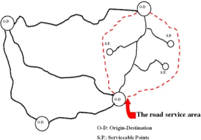
In the risk management of the inter-city road system, we need a quick assessment as the first structural or non-structural investigation and statistical analysis. This assessment should be done for each road in its service area. It means, it has to investigate the geographical extension of each road which actually connects an origin to a destination. A schematic sample of this definition is presented in Fig. 1.
This process, which is independent of detailed study of the features of road elements and only relies on the earthquake property of the region, is called the “Quick Seismic Risk Assessment”. In other words, the aim of the quick assessment is to do a large scale “prioritization” in the whole country or just do it for a large province. The proposed method thus provides a suitable tool for the governors and executive managers. In this kind of assessment, it has been used parameters which are independent of the time of accident. A factor is calculated for each parameter and they then are normalized to the corresponding maximums. Using a weight for each parameter, we can derive Eqn. 2.1 to combine the factors and the corresponding weights, as follows,
1
n Factor QFactor
Weight
R
(2.1) Where: “WeightFactor”, “Factor” and “n” correspondingly are weight, factor and the number of factors. The following two Eqns., i.e. (2.2) and (2.3) have been used to compare the parameters,obs
max
x
x
i
ij
ij
(2.2))
obs
min
obs
(max
)
obs
min
x
(
x
i
i
i
ij
ij
(2.3) Where:x
ij ,x'
ij ,minobs
i andmaxobs
i are the compared and non-compared index “i” for the city “j”, the minimum and the maximum values of the index “i” correspondingly. The main parameter is the seismicity of the area, which should be calculated from the standard acceleration zone maps. Other important factors in this prioritization are the relative length of the roads in seismically hazardous area and the passengers and goods transportations factors [Firoozi et al., 2011]. It deserves mentioning that in the introduced quick assessment method, the political, cultural, historical and similar factors are ignored.
3. IMPLEMENTATION OF PROPOSED MODEL TO IRAN
The selected important factors in this study have been classified in four different main groups, Hazard (H), Vulnerability (V), Serviceability (S) , Emergency rescue (E), with some subgroups in each main group. One traditionally method to evaluate the importance of each factor is to use the experts’ knowledge, which can be collected using some questionnaire forms. We prepared a suitable questionnaire form, by incorporating the point of views of at least 10 domain experts. This group of experts, which had expertise in structural, earthquake and transportation engineering, weighted the groups of parameters. After normalizing the total weights to 1, the definitive weights of each of four groups are calculated [Firoozi et al., 2011].
As the road service area is not completely characterized by the ministry of road and transportations, and there are numerous ambiguities in the current statistics as they are not accurate enough, the assessments and prioritization are done just based on the political borders of provinces. As a result, we calculated the seismic quick risk assessment using Eqn. 2.1 for each province of Iran, which are presented in Tables 3.1 and 3.2. On the other hand, other structures like avalanche guards, passages and other important factors like the ratio between the height of these constructions to the length of roads or the statistics of the height of constructions in different areas, can generally be considered, which have been ignored in this study, for the lack of available accurate information about these
factors.
Table 3.1. Quick Seismic Risk Assessment (QSRA) of Iranian provinces
Table 3.2. Prioritization of Iranian provinces
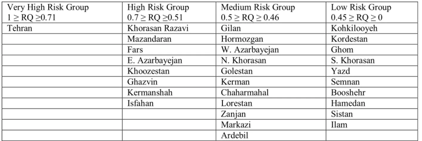
Now in a logical categorized, risks in different provinces can be divided in four groups of very high, high, medium and low risk regions. The risk in each province is shown in Table 3.3.
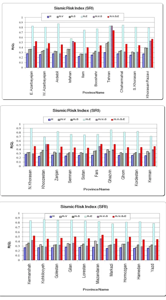
4. SENSITIVE ANALYSES OF qsra
A sensitivity analysis of the results with respect to the involved variables is one of the most important parts of establishing a new method. In this study, the sensitivity of the proposed method for the QSRA is measured for the main hazard factors, including seismicity property, measurement methods. As an example, we have shown the sensitivity results of risk index to the used groups in Fig. 2.
Province SRI Province SRI
E. Azarbayejan 0.52 Fars 0.52 W. Azarbayejan 0.48 Ghazvin 0.52 Ardebil 0.46 Ghom 0.45 Isfahan 0.51 Kordestan 0.45 Ilam 0.4 Kerman 0.47 Booshehr 0.44 Kermanshah 0.52 Tehran 0.74 Kohkilooyeh 0.45 Chaharmahal 0.47 Golestan 0.47 S. Khorasan 0.44 Gilan 0.50
Khorasan Razavi 0.57 Lorestan 0.46 N. Khorasan 0.47 Mazandaran 0.54
Khoozestan 0.52 Markazi 0.46
Zanjan 0.46 Hormozgan 0.49
Semnan 0.44 Hamedan 0.44
Sistan 0.43 Yazd 0.44
Province Ranking Province Ranking
Tehran 1 Chaharmahal 16
Khorasan Razavi 2 Lorestan 17
Mazandaran 3 Zanjan 18 Fars 4 Markazi 19 E. Azerbayejan 5 Ardebil 20 Khoozestan 6 Kohkilooyeh 21 Qazvin 7 Kordestan 22 Kermanshah 8 Ghom 23 Isfahan 9 S. Khorasan 24 Gilan 10 Yazd 25 Hormozgan 11 Semnan 26 W. Azarbayejan 12 Booshehr 27 N. Khorasan 13 Hamedan 28 Golestan 14 Sistan 29 Kerman 15 Ilam 30
Table 3.3. Categorized of Iranian provinces into different risk groups
5. CONCLUSIONS
The aim of this research was to develop a method for quick seismic risk assessment of inter-city roads (risk estimation in a global scale) and its implementation to Iran.
Important features of the proposed method can be outlined as follows: 1. Simple mathematical form
2. An ability to combine different seismic, structural and traffic variables 3. An Ability to apply to the national and provincial priorities
4. A possibility to easily making changes in the method and update the results
5. Extendibility to other natural hazards such as floods and landslides which can significantly affect the road networks
6. Extendibility to other countries with different standards and criteria
By incorporating this method, it was finally demonstrated that Tehran province has the roads with the highest risk and some provinces like Qom and Ilam have the roads with the lowest risk. By the way, the results achieved using quick risk assessment method, which is indeed to prioritize the roads and serving areas (currently in Iran, these are provinces), show that simple risk and vulnerability factor, regardless of transportation and complementary factors like the number of constructions and compound factors like the ratio between the number of passengers or goods transportations to the population of the area, lead to some unrealistic prioritizations.
The achieved results using the proposed quick risk assessment method can give a better perspective to the experts in transportation industry in the developing countries, which normally have some budget limitations. It can also give them a tool to prioritize the inter-city roads and allows them to optimally manage the budget for the purpose of reducing the seismic risks. The results of this study are also necessary for a detailed seismic risk assessment of the road, with some low-level risk assessments.
Very High Risk Group 1 ≥ RQ ≥0.71
High Risk Group 0.7 ≥ RQ ≥0.51
Medium Risk Group 0.5 ≥ RQ ≥ 0.46
Low Risk Group 0.45 ≥ RQ ≥ 0 Tehran Khorasan Razavi Gilan Kohkilooyeh
Mazandaran Hormozgan Kordestan Fars W. Azarbayejan Ghom E. Azarbayejan N. Khorasan S. Khorasan Khoozestan Golestan Yazd Ghazvin Kerman Semnan Kermanshah Chaharmahal Booshehr Isfahan Lorestan Hamedan
Zanjan Sistan Markazi Ilam Ardebil
AKCNOWLEDGEMENT
This paper is derived from one research project titled: “Developing a Quick Seismic Risk Assessment (QSRA) Model for Inter-City Road Systems: a case Study, Iran”. Therefore, authors wish to acknowledge Islamic Azad University (South Tehran Branch) for financial supports.
REFERENCES
Firoozi Nezamabadi, M., Yaghoobi Vayeghan, F. (2011). Developing a Quick Seismic Risk Assessment (QSRA) Model for Inter-City Road Systems: a case Study, Iran. A research projects, Islamic Azad University, South Tehran Branch, Tehran, Iran.
NGDC, “National Geophysical Data Center website (2006). http://www.ngdc.noaa.gov/seg/fliers/se-0801.shtml
Yaghoobi Vayeghan, F. and Hosseini, M. (2006). Key Issues on Seismic Risk Evaluation of Intercity Road Systems, Proc. Of International Disaster Reduction Conference (IDRC), Davos, Switzerland.
Hosseini, M., Yaghoobi Vayeghan, F. (2000). On Risk Management for Roads Subjected to Natural and Man-Made Hazards, Proc. Of IABSE Symposium Melbourne, Australia, , Paper No. 215.
Shinozuka, M., Feng, M.Q., Dong, X. (2000). Damage Assessment of a Highway Network under Scenario Earthquakes for Emergency Response Decision Support. SPIE's 7th Annual International Symposium on Smart Structures and Materials, Newport Beach.
Mayet, J. and Madanat, S. (2002). Incorporation of Seismic Considerations in Bridge Management Systems, Journal of Computer-Aided Civil and Infrastructure Engineering, Vol. 17, pp. 185-193.
Brabhaharan, P., Fleming, M.J. and Lynch, R. (2001). Natural Hazard Risk Management for Road Networks. Part I: Risk Management Strategies, Transfund New Zealand, Research Report 217, 75 pages.
Pellissier, V., Jaccard, P. A., Badoux, M. (2002). Decision Framework for Seismic Risk Management, Proc. Of 12th European Conference on Earthquake Engineering (12ECEE), U. K., Paper No. 622.
Basoz, N., Kiremidjian, A. S. (1996). Risk Assessment for Highway Transportation Systems. BLUME-118, John A. Blume Earthquake Engineering Center, Stanford, California, 257 pages.
Basoz N., Kiremidjian A. S., (1997). Risk Assessment of Bridges and Highway Systems from the Northridge Earthquake. Proc. Of the National Seismic Conference on Bridges and Highways: "Progress in Research and Practice", Sacramento, California, pp. 65-79.
Basoz, N., Kiremidjian, A. S. (1998). Risk Assessment for Highway Transportation Systems. Proc. Of the 6th U.S. National Conference on Earthquake Engineering [computer file], Earthquake Engineering Research Institute, Oakland, California, 12 pages.
Kiremidjian, A. S., Moore, J., Basoz, N., Burnell, K., Fan, Y., and Hortacsu, A. (2002). Earthquake Risk Assessment for Transportation Systems: Analysis of Pre-Retrofitted System”, Proc. Of the 7th U.S. National Conference on Earthquake Engineering, EERI, Boston.
Davidson, R. A. and Shah, H. C. (1997). An Urban Earthquake Disaster Risk Index. The John A. Blume Earthquake Engineering Center, Stanford, California, U.S.A., Report No. 121, 305 Pages.