CHARACTERIZING HUMAN-ENVIRONMENT INTERACTIONS IN THE GALÁPAGOS ISLANDS: A CASE STUDY OF LAND USE/LAND COVER
DYNAMICS IN ISABELA ISLAND
Amy L. McCleary
A dissertation submitted to the faculty of the University of North Carolina at Chapel Hill in partial fulfillment of the requirements for the degree of Doctor of Philosophy in the
Department of Geography.
Chapel Hill 2013
Approved by:
Dr. Stephen J. Walsh
iii
Abstract
AMY L. MCCLEARY: Characterizing Human-Environment Interactions in the Galápagos Islands: A Case Study of Land Use/Land Cover Dynamics in Isabela Island
(Under the direction of Stephen J. Walsh)
This dissertation examines contemporary land use and land cover (LULC) change in the communities and protected areas of Isabela Island to provide insights into
human-environment interactions in the Galápagos Islands of Ecuador. The growing human presence in Galápagos over the last four decades has been accompanied by significant changes in LULC on inhabited islands in the archipelago. Local stakeholders and decision-makers have recently called for a more integrative approach to understanding interactions between people and the environment in the archipelago.
This study is guided by two complementary bodies of work situated within the human-environment tradition of Geography – land change science and landscape ecology. First, support Vector Machine (SVM) and Object Based Image Analysis (OBIA) classifiers are evaluated for mapping LULC from high spatial resolution satellite images. The results show that thematic LULC classifications produced by OBIA are more accurate overall than those generated by SVM. However, important tradeoffs exist between improvements in classification accuracy and processing requirements.
iv
extensive within the communities due to the expansion and consolidation of built-up areas, and fragmentation of and declines in agriculture. The Galápagos National Park is primarily transformed by exotic plant invasion, forests expansion, and shrinking coastal lagoons.
v
Acknowledgements
My advisor, Steve Walsh, has been an extraordinary mentor. It would be difficult to recount all of the things I have learned from Steve, or the numerous ways in which he has contributed to my professional and personal development. I am extremely grateful for his support, guidance, and patience throughout this process. I would like to thank the members of my committee for their advice and comments, which have shaped my research and writing: Dr. Conghe Song, Dr. Aaron Moody, Dr. Ronald R. Rindfuss, and Dr. Kelley A. Crews. I am also thankful for the feedback provided by Dr. Wendy Wolford during the early stages of this work, as well as the support of Dr. Stephen Birdsall.
Financial support for this research was provided by the Carolina Population Center; the University of North Carolina at Chapel Hill Graduate School; the Center for Galapagos Studies at the University of North Carolina at Chapel Hill; the Douglas Eyre Travel Fund of the Geography Department at the University of North Carolina at Chapel Hill, and P.E.O. International.
vi
Galápagos National Institute), the Isabela Municipality, and the Charles Darwin Research Station. Logistical support in the Galápagos Islands was provided by the Center for Galapagos Studies at the University of North Carolina at Chapel Hill and the Universidad San Francisco de Quito.
I would also like to thank my colleagues, including members of the Spatial Analysis Lab and the Galápagos Projects – Dr. Laura Brewington, Kim Engie, Liz Hennessy, Dr. Benjamin Heumann, Dr. Daniel Weiss, Dr. Carlos Mena, Dr. Christine Erlien, Julie Tuttle, Patricia Polo, and Phil Page. I also extend my gratitude to Jan Hendrickson-Smith for her help and kindness during my time as a student at UNC.
vii
Table of Contents
List of Tables ...x
List of Figures ... xii
List of Abbreviations ...xv
CHAPTER 1: Introduction ...1
1.1 Background ...1
1.2 Study Aims...3
1.3 Study Area ...5
1.4 Chapter Summaries ...14
1.5 Theoretical Framework ...20
1.6 Contributions...26
1.7 Conclusions ...27
1.8 References ...28
CHAPTER 2: Comparison of Support Vector Machine and Object Based Image Analysis Approaches for Mapping Land Use/Land Cover ...38
2.1 Introduction ...38
2.2 Study Area ...41
2.3 Data & Pre-Processing ...43
2.4 Methods...50
2.6 Results and Discussion ...60
2.7 Conclusions ...68
viii
CHAPTER 3: Land Use and Land Cover Change in Southern Isabela Island,
2003-2010 ...78
3.1 Introduction ...78
3.2 Study Area ...83
3.3 Data & Pre-processing ...88
3.4 Methods...94
3.5 Coastal ISA Results ...108
3.6 Highlands ISA Results ...120
3.7 Discussion ...131
3.8 Conclusions ...141
3.9 References ...146
CHAPTER 4: Patterns and Drivers of Agricultural Abandonment, Plant Invasion, and Forest Expansion in Isabela Island ...156
4.1 Introduction ...156
4.2 Agricultural Land Abandonment ...162
4.3 Study Area ...166
4.4 Methods and Data ...170
4.5 Results and Discussion ...182
4.6 Conclusions ...200
4.7APPENDIX I: Landowner Questionnaire ...205
4.8 References ...213
CHAPTER 5: Conclusions ...221
5.1 Research Summary ...221
5.2 Challenges ...226
5.3 Contributions...228
ix
x
List of Tables
Table 2.1 LULC classification scheme with class description and training sizes ...50
Table 2.2 Accuracy of SVMs with various parameter settings ...52
Table 2.3 OBIA segmentation parameters ...55
Table 2.4 Error matrices for SVM and OBIA classifications ...61
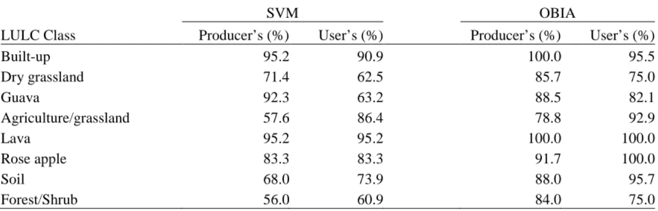
Table 2.5 Producer's and User's accuracies for SVM and OBIA classifications ...61
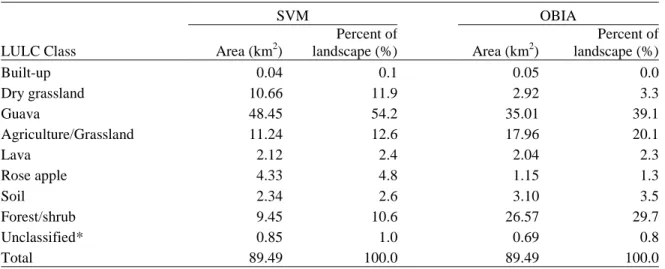
Table 2.6 Extent of LULC type, by area and percent of landscape, for each classifier ...67
Table 3.1 Satellite imagery and geometric correction parameters ...90
Table 3.2 LULC classification scheme with class description, and training and reference sizes ...93
Table 3.3 OBIA segmentation parameters ...96
Table 3.4 Coastal ISA (2003, QuickBird): OBIA classification rules with features and membership thresholds ...98
Table 3.5 Coastal ISA (2008, QuickBird): OBIA classification rules with features and membership thresholds ...99
Table 3.6 Coastal ISA (2010, WorldView-2): OBIA classification rules with features and thresholds ...100
Table 3.7 Highlands ISA (2004 QuickBird): OBIA classification rules with features and membership threshold ...101
Table 3.8 Highlands ISA (2010 WorldView-2): OBIA classification rules with features and membership threshold ...102
Table 3.9 Confusion matrix for 2008 QuickBird classification of the Coastal ISA ...109
Table 3.10 LULC statistics for the Coastal ISA, 2003-2010 ...111
Table 3.11 LULC statistics, by management zone, for the Coastal ISA ...112
Table 3.12 Matrix of from-to LULC changes (hectares) in the Coastal ISA, by management zone ...114
Table 3.13 Landscape metrics for the Coastal ISA, by management zone, 2003-2010 ...116
xi
Table 3.15 Confusion matrix for 2010 WorldView-2 classification of the Highlands
ISA ...120 Table 3.16 LULC statistics for the Highlands ISA, 2004-2010 ...123 Table 3.17 LULC statistics, by management zone, in the Highlands ISA ...124 Table 3.18 Matrix of from-to LULC changes (hectares) in the Highlands ISA, by
management zone ...125 Table 3.19 Landscape metrics for the Highlands ISA, by management zone,
2004-2010 ...128 Table 3.20 Class metrics for the Highlands ISA, by management zone, 2004-2010 ...129 Table 4.1 LULC change classes that comprise agriculture, guava, and forest
transitions in Santo Tomás ...171 Table 4.2 Description of independent variables and their sources ...174 Table 4.3 Independent variables retained in each regression model and hypothesized
effect on LULC transitions ...176 Table 4.4 Class metrics for LULC transitions ...183 Table 4.5 Area (A) and percent of farm property (B) used for agriculture, invaded by
guava, or covered by forest ...183 Table 4.6 Frequency and mean extent of change, by the farm’s dominant type of
change, for agriculture, guava, and forest ...184 Table 4.7 Logistic regression models for agricultural abandonment, guava invasion,
xii
List of Figures
Figure 1.1 The study area located in southern Isabela Island includes two intensive study areas (ISA). The Highlands ISA includes the community of Santo Tomás and part of the Galápagos National Park (GNP). The Coastal ISA
encompasses the community of Puerto Villamil and the surrounding GNP ...7 Figure 1.2 Vegetation zones organized by elevation on Isabela Island, according to
Wiggins and Porter (1971). Adapted from Trueman et al. (2011) ...8 Figure 1.3 Clockwise from top left: Lowland vegetation; farmers market in Puerto
Villamil; farm in Santo Tomás; Puerto Villamil beach; invasive Guava in the National Park; sign proclaiming “Isabela Grows for You”. Photos by
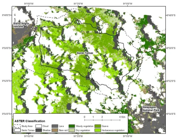
author (2008, 2009) ...13 Figure 2.1 Study area on southern Isabela Island. The community of Santo Tomás is
shown in dark grey, while Galápagos National Park (GNP) management
zones are shown in medium and light grey ...42 Figure 2.2 ASTER-based LULC classification (2005) of the study area generated for
in situ data collection ...45
Figure 2.3 WorldView-2 true color composite of the study area. The community of
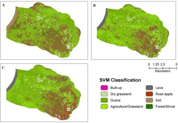
Santo Tomás is surrounded by the Galápagos National Park ...47 Figure 2.4 Results of SVM parameter testing. With a penalty value of 0 (A), the
SVM failed to generalize well. SVMs with moderate penalty values, such as 50 (B), had the highest overall accuracy. SVMs with large penalty
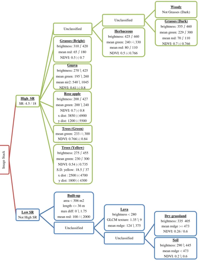
values, such as 200 (C), suffered from over-fitting ...53 Figure 2.5 Inheritance and semantic classification hierarchies (OBIA) ...58 Figure 2.6 OBIA classification flow chart. Blue boxes indicate classes applied at
level 1, green at level 2. Bold headings represent classes in the inheritance hierarcy; feature values for classification are listed below. Symbols represent mathematical functions used to assign feature values to
membership values: = greater than, = less than, /-\ = approximately,
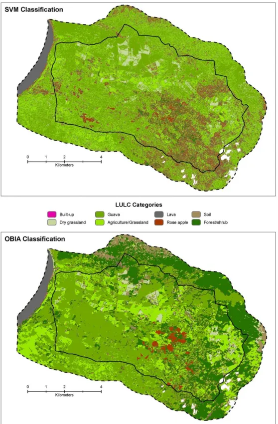
and |-| = exactly ...59 Figure 2.7 SVM (top) and OBIA (bottom) classification maps. White areas indicate
clouds. The community of Santo Tomás (central; solid line) is surrounded
by the Galápagos National Park ...66 Figure 2.8 Comparison of OBIA (left) and SVM (right) classified maps for two sites
xiii
Figure 3.1 The study site on (A) Isabela Island includes (B) the Highlands Intensive Study Area (ISA), centered on Santo Tomás and a portion of the
Galápagos National Park (GNP); and (C) the Coastal ISA centered on
Puerto Villamil and adjacent areas of the GNP ...84 Figure 3.2 ASTER LULC classifiations of the Coastal ISA (top) and Highlands ISA
(bottom) generated for field observation and in situ data collection ...89 Figure 3.3 Coastal ISA workflow of LULC assessment and change detection ...94 Figure 3.4 Highlands ISA workflow of LULC assessment and change detection ...95 Figure 3.5 LULC classification maps of the Coastal ISA for 2003, 2008, and 2010.
Clouds have been masked out (white) ...110 Figure 3.6 LULC change trajectories in the Coastal ISA. Early losses/gains refer to
changes in the 2003-2008 period; late gains/losses refer to 2008-2010
period ...111 Figure 3.7 LULC classification maps of the Highlands ISA for 2004 and 2010.
Clouds have been masked out (white) ...122 Figure 3.8 LULC change classes in the Highlands ISA, 2004-2010 ...123 Figure 3.9 Percentage of land in each distance interval converted to built-up cover in
the Coastal ISA ...133 Figure 3.10 The percentage of Galápagos National Park land covered by guava in
2004 and 2010 (y-axis) at 100 m distance intervals to the border with
Santo Tomás (x-axis) ...138 Figure 3.11 Change in guava cover between 2004 and 2010 (% relative to 2004) in
the Galápagos National Park (y-axis) at 100 m distance intervals to the
border with Santo Tomás (x-axis)...139 Figure 4.1 Study area on southern Isabela Island includes the the communities of
Santo Tomás and Puerto Villamil, as well as land protected by the
Galápagos National Park (GNP) ...167 Figure 4.2 Farm parcel boundaries superimposed on maps of agriculture, guava, and
forest transitions in Santo Tomás, 2004-2010 ...185 Figure 4.3 Number of Santo Tomás farms and area of land holdings in in each size
class, 2000 and 2009 ...193 Figure 4.4 Percent of economically active population (aged 15-64) of (A) Puerto
Villamil and (B) Santo Tomás employed in various sectors in 2001 and
xiv
Figure 4.5 Population pyramids for Isabela Island in 2001 and 2010, calculated from
xv
List of Abbreviations
AMSL – Above Mean Sea Level
ASTER – Advanced Spaceborne Thermal Emission Reflection Radiometer CA – Class Area
CDF – Charles Darwin Foundation
CGREG – Consejo de Gobierno de Régimen Especial de Galápagos
CLIRSEN – Centro de Levantamientos Integrados de Recursos Naturales por Sensores Remotos
DEM – Digital Elevation Model ED – Edge Density
ENN – Euclidean Nearest Neighbor Distance GCP – Ground Control Point
GEOBIA – Geographic Object Based Image Analysis GIS – Geographic Information Systems
GLCM – Gray-level Co-occurrence Matrix GNP – Galápagos National Park
GNPS – Galápagos National Park Service GPS – Global Positioning System
IGM – Instituto Geográfico Militar IJI – Interspersion-Juxtaposition Index
INEC – Instituto Nacional de Estadistica y Censo ISA – Intensive Study Area
IUCN – International Union for Conservation of Nature JM – Jeffries-Matusita
xvi LULC – Land Use and Land Cover
MAGAP – Ministerio de Agricultura, Ganadería, Acuacultura y Pesca MPS – Mean Patch Size
NNCV – Nearest Neighbor Coefficient of Variation NP – Number of Patches
NWS CPC – National Weather Service Climate Prediction Center OBIA – Object Based Image Analysis
PLAND – Percentage of Landscape
PSCV – Patch Size Coefficient of Variation RBF – Radial Basis Function
ROI – Region of Interest
RPC – Rational Polynomial Coefficients RMSE – Root Mean Square Error SR – Simple Ratio
SVM – Support Vector Machine SWIR – Short Wave Infrared TIR – Thermal Infrared
CHAPTER 1: Introduction
1.1 Background
The Galápagos Islands, renowned for their wildlife, are perhaps best known for inspiring Charles Darwin’s theory of evolution by natural selection. This volcanic island chain located in the Pacific Ocean is home to plant and animal species found nowhere else on Earth, such as giant tortoises. While the archipelago retains an estimated 95% of its original (i.e., pre-discovery) biodiversity (CDF and WWF, 2002), the social and ecological setting of the Galápagos has been drastically transformed over the past four decades. The archipelago was sparsely populated from its discovery by Europeans in the 1530s through the early 1970s. Since then, tens of thousands of Ecuadorians, driven by poor economic conditions on the mainland and attracted by the possibility of job opportunities in tourism and commercial fisheries, have immigrated to Galápagos (Bremner and Perez, 2002; Boersma et al., 2005; Watkins and Cruz, 2007). As a result, the population of Galápagos has more than quadrupled, growing from 4,000 residents in 1974 to more than 25,000 by 2010 (Epler, 2007; INEC, 2011). Over the same period, the tourism industry expanded considerably, cementing Galápagos’ reputation as one of the premier ecotourism destinations in the world. In 2011, more than 185,000 Ecuadorian and foreign visitors traveled to Galápagos (GNPS, 2012).
The growing human population in Galápagos has been accompanied by significant changes in land cover and land use, particularly on the four inhabited islands in the
2
plants and animals has increased in-step with population growth (Mauchamp, 1997; Kerr et al., 2004; Watkins and Cruz, 2007). Some of the worst invaders, such as guava (Psidium
guajava L.) and red quinine (Cinchona pubescens), transform plant communities composed
of native and endemic species within the protected area (Jäger et al., 2009) and reduce agricultural productivity on farms (Chiriboga et al., 2007). Coastal towns have become more urbanized with the expansion and densification of buildings and the development of
transportation infrastructure to support the influx of residents and tourists (Cléder and Grenier, 2010; Walsh et al., 2010; Gardener and Grenier, 2011; Hennessy and McCleary, 2011). As a result, bays and coastal lagoons have become polluted and freshwater sources have been depleted (Kerr et al., 2004; d’Ozouville et al., 2008), threatening aquatic
ecosystems and negatively impacting human health (Gelin and Gravez, 2002; Walsh et al., 2010). Further, the shift toward a more market-oriented economy based on tourism has led to agricultural land abandonment, which facilitates the expansion of invasive plants across communities and protected areas in the highlands (Rodriguez, 1993; Chiriboga and Maignan, 2006).
In 1998, the Ecuadorian government passed the Special Law for Conservation and Sustainable Development of the Province of Galápagos1 in an effort to address environmental degradation and increasing social conflicts in the archipelago. The law provided local
institutions more autonomy in governing Galápagos through a legal framework designed to ensure sustainable development of the inhabited islands and continued protection of
biodiversity throughout the archipelago (Ospina, 2008). By granting the province special status within Ecuador, lawmakers were able to institute strict immigration and residency
1
3
restrictions to limit population growth; create an inspection and quarantine system to prevent the introduction of non-native flora and fauna; and establish a quota system for hotel beds and cruise ship berths to regulate tourism (Epler, 2007; González et al., 2008).
The Special Law, however, was not entirely effective in curbing immigration,
limiting tourism, or slowing the introduction of exotic species. In the mid-2000s, national and international concern grew over continued environmental and social changes in the
Galápagos. In April, 2007 the President of Ecuador issued an Emergency Decree declaring Galápagos “at risk”, and the UNESCO World Heritage Committee took similar steps months later by inscribing the archipelago on their list of World Heritage In Danger.
In June 2010 the archipelago was formally removed from the In Danger list. At the time, a number of organizations voiced their apprehension over the de-listing, noting that many of problems cited in the World Heritage Committee’s decision to place Galápagos on the list had yet to be fully addressed and warranted continued action (Galapagos
Conservancy, 2010; IUCN, 2010a). Several authors have argued that this “social-ecological crisis”2 (González et al., 2008: 7) not only brings attention to recent social and ecological changes, but that it also highlights the need for more comprehensive and integrative approaches to understanding and addressing interactions between people and the
environment in Galápagos (Watkins and Cruz, 2007; González et al., 2008; Tapia et al., 2009).
1.2 Study Aims
The aim of this research is to contribute to an improved understanding of human-
2
4
environment interactions in the Galápagos Islands during the latter half of this “crisis” period by mapping and modeling the patterns and determinants of land use and land cover (LULC) change on Isabela Island, and by considering the consequences of these changes for people and the environment. Land change is recognized as an issue of global importance that has considerable implications for defining human-environment interactions (Gutman et al., 2004; Rindfuss et al., 2004b). The following research questions are addressed in this study:
1) Which classification approach – Support Vector Machine (SVM) or Object Based Image Analysis (OBIA) – is more effective in mapping LULC and discriminating among LULC types from remotely sensed data?
2) How has the composition and spatial configuration of LULC in Isabela Island changed between 2003/2004 and 2010? How do the patterns of LULC change differ between the island’s two communities and the Galápagos National Park?
3) What are the patterns of agricultural land abandonment, plant invasion, and forest expansion, at the farm and community levels, between 2004 and 2010 in Isabela Island? How do biophysical, geographic, socio-economic, and demographic factors contribute to these LULC transitions?
This study combines remote sensing, Geographic Information Systems (GIS), and statistical analyses of satellite images, spatial data layers representing the physical environment, secondary socio-economic and demographic data sets, and a small landowner survey to address these questions.
5
which may shed light on how these processes unfolded on other islands in the archipelago. Second, Isabela is important from the perspective of conservation because it has the highest concentration of endemic species in Galápagos (Epler, 2007; Proaño, 2007) and it contains the largest marine-coastal wetlands complex in the archipelago (Chávez and Cruz, 2002). The natural features that give the island its ecological value are also attractive to tourists, fueling speculation that Isabela could soon become a hub for land-based tourism (Epler, 2007; Walsh et al., 2010).
The objective of this introductory chapter is to provide an overview of the
dissertation. In the sections that follow, the characteristics of the study area are described; summaries of the specific research questions, hypotheses, data, and methods employed in each chapter are presented; the theories and bodies of literature that inform this work are briefly described; and the contributions of this research are highlighted.
1.3 Study Area
The Galápagos Archipelago is a chain of volcanic islands in the Pacific Ocean,
6
The archipelago has never been connected to the mainland (Simkin, 1984), and as a result, the plants and animals that colonized the islands evolved in isolation. This isolation, which persisted until the islands were discovered by Europeans in 1535, led to unique life forms highly adapted to their surroundings. The differences that emerged among species on different islands, and in comparison to mainland South America, are what Charles Darwin found so interesting about Galápagos (Durham, 2008). However, this isolation has declined over the last several decades due to the influx of people, goods, and non-native species (Watkins and Cruz, 2007; Durham, 2008).
1.3.1 Biophysical Setting
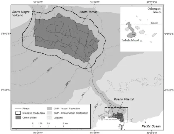
This research takes place in southern Isabela Island, between Latitude 0°47' and 0°58' S and Longitude 91°06' to 90°59' W (Figure 1.1). Located in the western portion of the Galápagos, Isabela is the largest (4,588 km2) and one of the youngest islands in the archipelago. The island is comprised of six shield volcanoes geographically divided from north to south by Perry Isthmus; northern Isabela includes Alcedo, Ecuador, Darwin, and Wolf volcanoes, while southern Isabela consists of Sierra Negra and Cerro Azul. Two intensive study areas (ISAs) are located along the southeastern flank of Sierra Negra Volcano. The Coastal ISA, totaling 8 km2, encompasses the growing community of Puerto Villamil (1.5 km2), and a surrounding area protected under the Galápagos National Park (6.5 km2). The Highlands ISA includes the rural community of Santo Tomás (52 km2) and a buffer that extends into the National Park (8 km2).
7
Figure 1.1 The study area located in southern Isabela Island includes two intensive study areas (ISA). The Highlands ISA includes the community of Santo Tomás and part of the Galápagos National Park (GNP). The Coastal ISA encompasses the community of Puerto Villamil and the surrounding GNP
22°C to 30°C (monthly), and sporadic rain showers are common (Guézou et al., 2007; Trueman and d’Ozouville, 2010). The cool season, from June to December, is marked by a reduction in precipitation and air temperatures (19°C to 26°C) (ibid.). Although it is drier along the coast, a near permanent fog, called garúa, occurs in the highlands during this period due to an inversion layer that forms over the archipelago (Collins and Bush, 2011; Pryet et al., 2012). Weather patterns shift markedly, however, during El Niño (warmer, wetter) and La Nina (cooler, drier) events.
8
characterized by high topographic relief. Elevation rises gradually from 80 m to 1040 m AMSL from southeast to northwest, while slope angles vary from 0° to 42°. The parent geological material is primarily basaltic lava flows and pyroclastic materials, with extremely shallow sandy soils dominating the lowlands, and clayey loams up to several meters in depth in the highlands (Laruelle, 1966; Franz, 1980; Valarezo, 2008).
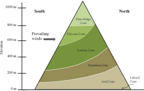
Vegetation patterns on Isabela Island are determined by geomorphology (which affects soils and landforms), elevation (which generates temperature and moisture gradients), and aspect (which controls moisture availability) (Shimizu, 1997). Six vegetation zones are commonly recognized in southern Isabela, progressing upward in elevation from the coast (Figure 1.2): littoral, arid, transition, scalesia, miconia, and fern-sedge (Wiggins and Porter, 1971; McMullen, 1999). Vegetation along the coastal fringe and within several meters of coastal lagoons, the littoral zone, is comprised of woody shrubs and small trees, as well as a few salt-tolerant herbs and perennial grasses (Wiggins and Porter, 1971; Colinvaux, 1984). Mangrove forests here are composed of three species – Laguncularia racemosa (white),
9
Avicennia germinans (black), and Rhizophora mangle (red) – and associated species such as Hippomane mancinella (manzanillo) (Wiggins and Porter, 1971; Heumann, 2011).
Vegetation in the arid zone, encompassing dry lowland communities immediately inland and up to 80 m in elevation AMSL, includes several endemic cacti (Opuntia spp.), a mix of spiny shrubs and small trees such as cat’s claw (Zanthoxylum fagara (L.) Sarg.) and palo santo (Bursera graveolens), and herbs that emerge during the wet season (Wiggins and Porter, 1971; Colinvaux, 1984). The Coastal ISA lies within the littoral and arid zones on Isabela.
The Highlands ISA coincides with the other four vegetation zones – the transition zone composed of evergreen and semi-deciduous plants, and the scalesia, miconia, and fern-sedge zones, sometimes collectively referred to as the humid zone, where introduced vegetation occupies areas once dominated by endemic Scalesia cordata forests and open grasslands. The transition zone begins at an elevation of 80 m AMSL and continues upward to the lower edge of the humid zone at approximately 200 m AMSL. As its name implies, the transition zone is an intermediate region that includes xerophytic plants that extend upward from the arid zone (e.g., B. graveolens) and mesophytic plants (e.g., Psidium galapageium) that are characteristic of the humid zone at higher elevations (Wiggins and Porter, 1971; Itow, 2003).
10
for cultivation have significantly transformed these communities, and invasive plants are replacing native vegetation within the humid zone (Tye, 2001). For example, S. Cordata, a small, endemic tree that was once ubiquitous in the humid zone of southern Isabela has been almost wholly replaced by introduced vegetation such as guava (Psidium guajava L.) and rose apple (Syzygium jambos (L.) Alston), and is now considered extremely threatened by the International Union for Conservation of Nature (IUCN) (IUCN, 2010b; Philipp and Nielsen, 2010; Mauchamp and Atkinson, 2010). Guava and rose apple, woody species once cultivated for their fruit, now form dense, monospecific stands that shade out native vegetation (Soria et al., 2002) and significantly transform the ecosystems they invade in the archipelago (Tye et al., 2002).
1.3.2 Social Setting
Isabela Island (Isabela Canton) consists of two parishes: the urban parish of Puerto Villamil and the rural parish of Tomás de Berlanga (locally referred to as Santo Tomás). Cantons, administrative divisions in Ecuador equivalent to the county-level in the United States, are sub-divided into parishes that are classified as urban if they include the provincial capital or the cantonal head, and rural otherwise. These parishes make up only 1.1% of Isabela’s terrestrial area, with the remaining 98.9% of land on the island protected under the Galápagos National Park.
11
subject to regulations adopted by the Province of Galápagos, and by the Ecuadorian state. The Galápagos National Park Service manages the protected areas on Isabela Island, which make up all land outside the island’s two communities. Human settlements are not permitted in the National Park, but a limited number of special uses are permitted in select sites
including tourism, transportation infrastructure, and water extraction.
The history of human settlements in Isabela, as in the rest of Galápagos, is relatively short. In the late 1890s, a small number of families and individuals settled Isabela Island. Although a few people resided in the port town of Puerto Villamil, located on the island’s southeastern coast, the majority of households lived and worked on a large hacienda established in the humid highlands near what is now Santo Tomás (Perry, 1984; Ospina-Peralta, 2006; Chiriboga and Maignan, 2006). Settlement of Isabela coincided with
Ecuadorian policies meant to populate Galápagos to reinforce the state’s territorial claims to the remote archipelago (Constantino, 2007).
Within thirty years of its establishment, the hacienda was dissolved and its land was redistributed among former laborers, each of whom received between 10 and 20 ha of land (Chiriboga and Maignan, 2006). These small, family farms were characterized by
12
other plants introduced from the mainland. In 1974, fifteen years after the Galápagos National Park was established, the boundaries of the protected area were formalized
(Maignan, 2007; Villa and Segarra, 2010). Existing settlements, including Santo Tomás and Puerto Villamil, were excluded from the National Park and human activities were restricted to areas that had already been cleared, developed, or otherwise modified.
In the two decades that followed, Isabela’s economy diversified and jobs outside of traditional industries (i.e., agriculture and artisanal fishing) increased (Ospina-Peralta, 2006; MacFarland and Cifuentes, 1996). A substantial number of administrative jobs in local government agencies and institutions were created after Galápagos was incorporated as the 22nd province of Ecuador (Epler, 2007). Expansion of land-based tourism on the island led to increased employment opportunities in construction and in businesses catering to tourists (e.g., hotels, restaurants, tour companies) (González et al., 2008). The majority of these new jobs were located in Puerto Villamil, where the central government funded development projects to enhance infrastructure and public services, such as electricity, water, and schools (Epler, 2007). Lucrative off-farm job opportunities combined with declining agricultural profits attracted many people to move to Puerto Villamil (Chiriboga et al., 2007).
Landowners increasingly invested less time and money in agricultural production, and as a result, marginal agricultural lands were abandoned (PNG, 2005; Chiriboga and Maignan, 2006; González et al., 2008).
A fishing boom in Galápagos during the 1990s, coupled with poor economic
13
870 residents in 1990, and 1,600 in 2001, to more than 2,200 by 2010; this equates to growth rates between 5.9% and 3.3% per year (authors calculations based on INEC, 2002; INEC, 2011). Between 1992 and 2009, the extent of Puerto Villamil nearly tripled, and the density of buildings and roads within the community increased significantly (Walsh et al., 2010). Continued development of the community is visible in the construction of new homes, hotels and restaurants, and new dock and airport facilities meant to improve accessibility for tourists (ibid.). Isabela Crece por Ti (Isabela Grows for You), the unofficial motto of the island, can be seen on signs, park benches, and vehicles across town and seems indicative of the Island’s future. Figure 1.3 shows several photos of the communities and protected areas on Isabela Island.
14
In contrast, the number of Santo Tomás residents has declined since 1990; in 2010, fewer than 170 individuals (7.6% of Isabela’s population) remained in the community (INEC, 2011). Land within the community is still used primarily for crop cultivation and livestock grazing, and is characterized by residential buildings set on small- to medium-sized parcels. However, an increasing amount of agricultural land is no longer actively managed and has been abandoned as farm households continue to emigrate to Puerto Villamil (Chiriboga and Maignan, 2006).
1.4 Chapter Summaries
The research presented in this dissertation is organized into three chapters that take the form of journal articles. The research questions, hypotheses, data sets, and methods pertaining to each chapter are summarized below. The last chapter of the dissertation synthesizes the research questions, analyses, and results; discusses the contributions and implications of the major findings; and identifies potential avenues for future research.
1.4.1 Chapter 2: Comparison of Support Vector Machine and Object Based Image Analysis
Approaches for Mapping Land Use/Land Cover
15
feature space. OBIA is a rule-based classification approach that integrates image processing and GIS functionalities in the classification of non-overlapping image segments, or objects, which represent landscape features. In addition to the spectral data contained in the image bands, contextual information, such as the spatial, topological, and textural characteristics of the image objects, can be used to define the inclusion or exclusion parameters for OBIA classification (Lang, 2008).
In Chapter 2, SVM and OBIA classifiers are evaluated for mapping LULC from a high spatial resolution satellite image of southern Isabela Island. Two research questions are specifically addressed in this chapter:
1) How do the LULC classification results from SVM and OBIA differ?
2) Which classification approach is more effective in distinguishing and mapping LULC as measured by the accuracy of the resulting thematic maps?
16
1.4.2 Chapter 3: Land Use and Land Cover Change in Southern Isabela Island, 2003-2010
Inhabited islands in the Galápagos Archipelago have undergone major changes in LULC over the last three decades. Land change has been recognized as an issue of global importance as land use activities and resultant changes in land cover can change the structure and function of ecosystems (Foley et al., 2005) and can reduce biodiversity through habitat modification (Pimm and Raven, 2000; Sala et al., 2000). In many countries, protected areas have been established as a mechanism to limit the direct impacts of human activities on biodiversity and to maintain ecosystem functioning. Unfortunately, data on LULC and change in the Galápagos Islands are limited (González et al., 2008). The lack of spatially-explicit data and the coarse nature of existing maps have hampered previous efforts to quantify changes in land use for the purpose of resource management in communities (Villa and Segarra, 2010), and to assess human-caused land degradation (Watson et al., 2009).
The aim of Chapter 3 is to provide an improved understanding of contemporary LULC change in the Galápagos Islands by quantifying recent changes in the communities and surrounding protected areas of southern Isabela Island. Two research questions are specifically addressed:
1) How has the composition and spatial configuration of LULC changed in southern Isabela Island between 2003/2004 and 2010?
It is hypothesized that during this period, the amount of land devoted to agriculture declined and built-up land use increased in southern Isabela. Declines in vegetation cover have likely occurred where built-up cover increased, and an expansion of invasive
17
natural land covers – forest/shrubs, grasslands, coastal vegetation, and coastal lagoons – became more fragmented as they were converted to other cover types.
2) How do the patterns of LULC change differ between the communities and the protected areas?
LULC in the protected areas is hypothesized to be less likely to change due to the large size of the protected area in comparison to land set aside for the communities, and because of restrictions on land use within the National Park. It is expected, however, that some changes in land cover have occurred in the protected area as the result of land use change within the adjacent communities (e.g., invasion of National Park grasslands by introduced plants found in agricultural fields), particularly along park-community borders.
18
1.4.3 Chapter 4: Patterns and Drivers of Agricultural Abandonment, Plant Invasion, and Forest Expansion in Southern Isabela Island
Agricultural extensification and deforestation remain prominent land change processes in many parts of Latin America, but an increasing number of countries are witnessing the abandonment of marginal agricultural lands and the subsequent recovery of forest ecosystems (Ramankutty and Foley, 1999a; Aide and Grau, 2004; Grau and Aide, 2008). Agricultural land abandonment was first reported in the Galápagos Islands in the 1980s (Rodriguez, 1989; Rodriguez, 1993; González et al., 2008), but the rate of
abandonment and the prevalence of abandoned farms appears to have increased in the last two decades (Chiriboga and Maignan, 2006; Maignan, 2007). Several reasons for this
process have been proposed, including a shift toward a more market-oriented economy based on tourism rather than traditional livelihoods (e.g., fishing and agriculture); migration of farm households to the coastal communities to take advantage of these new opportunities; and declines in available labor to maintain productive farms.
The goal of Chapter 4 is to identify patterns and potential determinants of agricultural land abandonment and resultant land cover changes (exotic plant invasion and forest
expansion) in Isabela Island between 2004 and 2010. Three research questions are addressed: 1) What are the patterns of agricultural land abandonment, plant invasion, and forest
expansion in Isabela Island, at the farm and community level, between 2004 and 2010?
Previous work has shown that the amount of land devoted to agricultural land use
19
forest expansion likely occurred where agricultural land was abandoned (i.e., in old fields), leading to similar patterns of abandonment, invasion and forest expansion.
2) How are agricultural land abandonment, plant invasion, and forest expansion related to variables representing the biophysical and geographic characteristics of southern Isabela?
Agricultural abandonment is hypothesized to be associated with marginal sites located at lower elevations and on steeper slopes, where the geomorphic substrate is rocky, and in remote areas (i.e., farther from roads) where the cost of production is greater. Guava can adapt to a range of environments and climatic conditions, so it is expected that guava invasion will be associated with all but the lowest elevations, regardless of slope or aspect, and in the least accessible sites. Forest expansion is expected to be associated with higher elevation sites, in areas where the substrate is less rocky, and in remote sites far from roads and Puerto Villamil.
3) In what ways have socio-economic and demographic characteristics of the island’s communities changed between 2000 and 2010, and how might these factors be associated with agricultural abandonment?
As a result of agricultural land abandonment, crop harvests and livestock production are expected to decline. It is hypothesized that increased off-farm employment opportunities will result in a larger proportion of the island’s population residing in Puerto Villamil. The proportion of farms employing agricultural laborers is not expected to rise, however, due to declines in the profitability of agriculture.
20
the transition maps in a GIS database to summarize the extent and magnitude of changes at the farm and community level. Logistic regression models are then developed to assess how agricultural abandonment, guava invasion, and forest expansion (dependent variables) are related to a set of biophysical and geographic factors (e.g., topography, geomorphology, distance to roads; independent variables); one model is generated for each LULC transition.
Descriptive statistics and cross-tabulations of secondary data – including national population censuses (INEC, 2002; 2011), a national agricultural census (INEC and MAG, 2001), and a living standards survey of Galápagos (INEC and CGREG, 2010) – are generated to assess changes in the socio-economic and demographic characteristics of Santo Tomás and Puerto Villamil between 2000 and 2010. These data are supplemented by information from interviews of 45 Santo Tomás landowners conducted by the author in 2008, which are used to contextualize the quantitative analyses and to provide a deeper understanding of LULC transitions and population change in southern Isabela. The lack of fine-level spatial
information for the secondary data sets prevents quantitative modeling of the socio-economic and demographic drivers of the transitions. The goal, therefore, is to generate hypotheses about the social factors responsible for land change in Isabela.
1.5 Theoretical Framework
21
of LULC change. Landscape ecology considers the linkages between landscape pattern, process, and function and provides a set of metrics with which to characterize landscape pattern.
1.5.1 Land Change Science
Concern over global environmental change has led to a resurgence of research addressing human impacts on, and interactions with, the Earth’s surface (Rindfuss et al., 2004b). The renewed focus on human-environment interactions has been accompanied by greater interest in understanding land use change (de Sherbinin, 2002). Research on human-environment interactions examined through the lens of land use change has been prolific over the last decade, with contributions from a number of different research communities, such as remote sensing, landscape ecology, political ecology, and resource economics among others (Turner et al., 2007). These efforts have generated an interdisciplinary effort to better
understand the patterns and processes of LULC change referred to as land change science, or
integrated land change science (Gutman et al., 2004; Rindfuss et al., 2004b; Turner et al.,
2007). Studies under the umbrella of land change science have integrated remotely sensed, biophysical, and social science data and approaches to (1) observe and monitor LULC and its change; (2) explain the biophysical, social, and environmental processes that generate
changes in land use, and often as a result, land cover; and (3) use information about the patterns and determinants of land use change to improve spatially-explicit models of coupled human-natural systems (Rindfuss et al., 2004b; Turner et al., 2007).
22
(Lambin et al., 2003). Land change has been recognized as an issue of global importance because land use activities and resultant changes in land cover can impact the physical environment and societies alike. For example, land use practices can reduce biodiversity through habitat modification and the direct exploitation of native species (Pimm and Raven, 2000; Sala et al., 2000). Changes in LULC can also alter the structure and function of
ecosystems (Foley et al., 2005). Such alterations may diminish the capacity of ecosystems to provide services that support human needs, such as the provisioning of freshwater or the capacity for food production (Vitousek et al., 1997).
Remote sensing and image interpretation have become standard approaches for mapping LULC. Remotely sensed imagery can not only cover large spatial extents but can also capture information for features of small grains and extents, particularly with the increased availability of moderate resolution data, such as Landsat, combined with high spatial resolution products, such as Ikonos or QuickBird (Walsh et al., 2004). Image
interpretation and GIScience methodologies include automated approaches for mapping and assessing change that are efficient and easily repeatable, which can reduce the costs
associated with in situ data collection and field visits.
23
biophysical and geographic factors, such as climate, soils, topography, and distance to roads or market centers can define the predisposing environmental conditions for land use change (Geist et al., 2006).
Determining the factors that generate land use change requires integrative approaches that link human and natural systems (Rindfuss et al., 2004b). This can be accomplished by directly linking people to the lands that they own, manage, or otherwise influence. For example, the socio-economic characteristics of agricultural households, and the biophysical characteristics of the land they manage, can be spatially associated with farm-level land use change (Walsh et al., 2004). However, linking presents both theoretical and methodological challenges (c.f., Fox et al., 2003), such as deciding whether to link units of land to the people that manage them, or to start with people and link them to the land they own; and how to deal with possible scale mismatches between social, biophysical, and land use datasets (Rindfuss et al., 2004a; Rindfuss et al., 2004b).
Studies of the expansion of agriculture, deforestation, and urbanization have
24
however, and rates of abandonment appear to be on the rise (Baudry, 1991; Gellrich and Zimmermann, 2007; Hobbs and Cramer, 2007). As previously noted, agricultural land abandonment has even been documented in the Galápagos Islands in the last three decades (MacFarland and Cifuentes, 1996; Chiriboga and Maignan, 2006; Maignan, 2007). Despite the increasing prevalence of agricultural abandonment, the patterns, drivers, and impacts of land abandonment and forest transition remain poorly understood and are an active area of research within land change science (Gellrich and Zimmerman, 2007; Sluiter and de Jong, 2007; Baumann et al., 2011; Diaz et al., 2011).
1.5.2 Landscape Ecology
Landscape ecology provides a theoretical framework and methodology to analyze spatial pattern in order to understand the underlying processes associated with LULC change (Crews-Meyer, 2004). Of particular interest within the field is the detection and
characterization of pattern, understanding how and why it develops and changes over time, and its implications for landscape function. Landscape, as the term is used here, refers to an area characterized by spatial heterogeneity (in relation to some factor of interest), on the order of a few hectares to hundreds of square kilometers in size (Turner et al., 1989; Turner et al., 2001). Landscapes are composed of patches, defined as homogenous areas of particular LULC types that differ from their surroundings (Turner et al., 2001).
Land cover patterns are generated by the complex interaction of social and
25
maintain biodiversity) (Turner et al., 1989; Forman, 1995). Quantifying the spatial and temporal patterns of LULC can facilitate the inference of landscape processes that drive LULC change (Brown et al., 2000; Crews-Meyer, 2004). In fact, the description and
quantification of landscape composition and configuration, the two components of pattern, is a prerequisite for studies of pattern-process relations (McGarigal and Marks, 1994; Schröder and Seppelt, 2006).
The scale of observation is an important consideration in landscape studies. The patterns that can be observed are determined by the scale of observation, which, in turn, is used to infer process (Crews-Meyer, 2006). Scale encompasses both grain (resolution of the data) and extent (scope or boundary of the data). Scale dependence, or how patterns and processes vary with scale, has been an area of extensive research within geography and landscape ecology. Landscapes exhibit scale dependency in two ways. First, patterns may be exhibited only at particular scales or ranges of scale, such that they are seen as operating at particular levels of organization (Lam and Quattrochi, 1992). Second, the ability to discern pattern depends on the scale of observation and analysis. The spatial and temporal grain and extent of data employed to measure landscape pattern (and changes in pattern) can affect the types of pattern that can be observed, and will therefore impact the inference of process.
26
patches, classes (integrated over all the patches of a particular type), or the landscape
(integrated over all patch types or classes across the full extent of the landscape) (McGarigal, 2002). The description of landscape pattern falls into two categories based on the
components of pattern: composition and configuration. Composition refers to the variety of LULC types and their relative abundances. Configuration, or structure, is the spatial
arrangement of patches on the landscape.
1.6 Contributions
27
the patterns, causes, and consequences of agricultural land abandonment, an important addition to the broader study of land use change.
1.7 Conclusions
The goal of this study is to contribute to an improved understanding of human-environment interactions in the Galápagos Islands during the latter half of the
28
1.8 References
Aide, T. M., and H. R. Grau. 2004. Globalization, migration, and Latin American ecosystems. Science 305 (5692):1915-1916.
Baudry, J. 1991. Ecological consequences of grazing extensification and land abandonment: Role of interactions between environment, society and techniques. Options
Méditerranées: Série Séminaries A, Séminaires Méditerranéens 15:13-19.
Baumann, M., T. Kuemmerle, M. Elbakidze, M. Ozdogan, V. C. Radeloff, N. S. Keuler, A. V. Prishchepov, I. Kruhlov, and P. Hostert. 2011. Patterns and drivers of post-socialist farmland abandonment in Western Ukraine. Land Use Policy 28 (3):552-562.
Boersma, P. D., H. Vargas, and G. Merlen. 2005. Living laboratory in peril. Science 308 (5724):925-925.
Bremner, J., and J. Perez. 2002. A Case Study of Human Migration and the Sea Cucumber Crisis in the Galapagos Islands. AMBIO: A Journal of the Human Environment 31 (4):306-310.
Brown, D. G., B. C. Pijanowski, and J. D. Duh. 2000. Modeling the relationships between land use and land cover on private lands in the Upper Midwest, USA. Journal of
environmental management 59 (4):247-263.
Charles Darwin Foundation (CDF) and World Wildlife Fund (WWF). 2002. A Biodiversity
Vision for the Galapagos Islands. Puerto Ayora, Galapagos: Charles Darwin
Foundation.
Chávez, J. A., and E. Cruz. 2002. Information Sheet on Ramsar Wetlands (RIS): Sur de
Isabela. Ramsar Convention Secretariat.
Chiriboga, R., and S. Maignan. 2006. Historia de las relaciones y elementos de la
reproduccion social agraria en Galapagos. Puerto Ayora, Galapagos: Global
Environment Facility and the United Nations Development Programme, Producto Dos (A): Proyecto ECU/00/G31 Especies Invasoras de Las Galapagos.
Chiriboga, R., S. Maignan, and F. Hidalgo. 2007. Crisis del sector agropecuario y control de especies invasoras en Galápagos. In Galápagos: Migraciones, Economía, Cultura,
Conflictos y Acuerdos, ed. P. Ospina and C. Falconí, 145-150. Quito: Universidad
Andina Simón Bolívar.
29
Cléder, E., and C. Grenier. 2010. Taxis in Santa Cruz: Uncontrolled mobilization. In
Galapagos Report 2009-2010, 29-39. Puerto Ayora, Galapagos, Ecuador: Charles
Darwin Foundation, Galapagos National Park, and Governing Council of Galapagos. Colinvaux, P. A. 1984. The Galápagos Climate: Present and Past. In Galapagos, ed. R. Perry,
55-69. Oxford: Pergamon.
Collins, A., and M. B. Bush. 2011. An analysis of modern pollen representation and climatic conditions on the Galápagos Islands. The Holocene 21 (2):237-250.
Constantino, J. C. 2007. Fishermen, Turtles, and Darwin: Galapagos Lives in Evolution's Laboratory. Ph.D. dissertation, University of Michigan.
Crews-Meyer, K. A. 2006. Temporal Extensions of Landscape Ecology Theory and Practice: Examples from the Peruvian Amazon. Professional Geographer 58 (4):421-435. ——— 2004. Agricultural landscape change and stability in northeast Thailand: historical
patch-level analysis. Agriculture, Ecosystems & Environment 101 (2–3):155-169. de Sherbinin, A. 2002. CIESIN Thematic Guides: A Guide to Land-Use and Land-Cover
Change (LUCC). Columbia University: CIESIN.
Diaz, G. I., L. Nahuelhual, C. Echeverría, and S. Marín. 2011. Drivers of land abandonment in Southern Chile and implications for landscape planning. Landscape and Urban
Planning 99 (1):207-217.
d'Ozouville, N., B. Deffontaines, J. Benveniste, U. Wegmueller, S. Violette, and G. de Marsily. 2008. DEM generation using ASAR (ENVISAT) for addressing the lack of freshwater ecosystems management, Santa Cruz Island, Galapagos. Remote Sensing
of Environment 112 (11):4131-4147.
Durham, W. H. 2008. Fishing for Solutions: Ecotourism and Conservation in Galapagos National Park. In Ecotourism at Work in the Americas, ed. A. Stronza and W. H. Durham, 66-90. Cambridge, MA: CABI.
Entwisle, B., and P. C. Stern. 2005. Population, Land Use, and Environment: Research
Directions. Washington, D.C.: The National Academies Press.
Epler, B. 2007. Tourism, the Economy, Population Growth, and Conservation in Galapagos. Puerto Ayora, Santa Cruz Island: Charles Darwin Foundation.
Foley, J. A., R. DeFries, G. P. Asner, C. Barford, G. Bonan, S. R. Carpenter, F. S. Chapin, M. T. Coe, G. C. Daily, H. K. Gibbs, J. H. Helkowski, T. Holloway, E. A. Howard, C. J. Kucharik, C. Monfreda, J. A. Patz, I. C. Prentice, N. Ramankutty, and P. K. Snyder. 2005. Global Consequences of Land Use. Science 309 (5734):570-574. Forman, R. T. T. 1995. Some general principles of landscape and regional ecology.
30
Foster, D. R. 1992. Land-Use History (1730-1990) and Vegetation Dynamics in Central New England, USA. Journal of Ecology 80 (4):753-771.
Fox, J., R. R. Rindfuss, S. J. Walsh, and V. Mishra. 2003. People and the Environment:
Approaches for Linking Household and Community Surveys to Remote Sensing and GIS. Boston: Kluwer Academic Publishers.
Franz, H. 1980. Old soils and land surfaces on the Galápagos islands. GeoJournal 4 (2):182-184.
Froyd, C., J. Lee, A. Anderson, S. Haberle, P. Gasson, and K. Willis. 2010. Historic fuel wood use in the Galápagos Islands: identification of charred remains. Vegetation
History & Archaeobotany 19 (3):207-217.
Galapagos Conservancy. 2010. Conservation challenges remain as the World Heritage Committee removes Galapagos from the list of Sites in Danger. Available from http://www.galapagos.org/2008/index.php?id=256 (last accessed March 11 2011). Galápagos National Park Service (GNPS). 2012. Ingreso de Turistas a Galápagos de 2011.
Available from
http://galapagospark.org/documentos/turismo/pdf/Informe_ingreso_turistas_2011.pdf (last accessed November 1 2012).
Gardener, M. R., and C. Grenier. 2011. Linking Livelihoods and Conservation: Challenges Facing the Galapagos Islands. In Island Futures: Conservation and Development
Across the Asia-Pacific Region, ed. G. Baldacchino and D. Niles, 73-85. New York:
Springer.
Gardner, R., B. Milne, M. Turner, and R. O'Neill. 1987. Neutral models for the analysis of broad-scale landscape pattern. Landscape Ecology 1 (1):19-28.
Geist, H. J., and E. F. Lambin. 2002. Proximate Causes and Underlying Driving Forces of Tropical Deforestation. Bioscience 52 (2):143.
Geist, H., W. McConnell, E. F. Lambin, E. Moran, D. Alves, and T. Rudel. 2006. Causes and Trajectories of Land-Use/Cover Change. In Land-Use and Land-Cover Change.
Local Processes and Global Impacts, ed. E. F. Lambin and H. Geist, 41-70.
Germany: Springer.
Gelin, A., and V. Gravez. 2002. Knowledge and Conservation of Galapagos Islands Coastal
Lagoons (Ecuador). Puerto Ayora, Galapagos: Basler Stiftung für Biologische
Forschung, Charles Darwin Biological Station, and Galapagos National Park. Gellrich, M. G., P. Baur, and N. E. Zimmerman. 2007. Natural forest regrowth as a proxy
variable for agricultural land abandonment in the Swiss mountains: a spatial statistical model based on geophysical and socio-economic variables. Environmental Modeling
31
Gellrich, M., and N. E. Zimmermann. 2007. Investigating the regional-scale pattern of agricultural land abandonment in the Swiss mountains: A spatial statistical modelling approach. Landscape and Urban Planning 79 (1):65-76.
González, J. A., C. Montes, J. Rodriguez, and W. Tapia. 2008. Rethinking the Galapagos Islands as a Complex Social-Ecological System: Implications for Conservation and Management. Ecology and Society 13 (2):13.
Grau, H. R., and M. Aide. 2008. Globalization and Land-Use Transitions in Latin America.
Ecology and Society 13 (2):1-16.
Guézou, A., P. Pozo, and C. Buddenhagen. 2007. Preventing Establishment: an Inventory of Introduced Plants in Puerto Villamil, Isabela Island, Galapagos. PLoS ONE 2
(10):e1042.
Gustafson, E. J. 1998. Quantifying landscape spatial pattern: what is state of the art?
Ecosystems 1 (2):143-156.
Gutman, G., A. C. Janetos, C. O. Justice, E. F. Moran, J. F. Mustard, R. R. Rindfuss, D. Skole, B. L. Turner II, and M. A. Cochrane. 2004. Land Change Science. Observing,
Monitoring and Understanding Trajectories of Change on the Earth's Surface. New
York: Kluwer Academic Publishers.
Hansen, M. C., S. V. Stehman, P. V. Potapov, T. R. Loveland, R. G. Townshend, R. S. DeFires, K. W. Pittman, B. Arunarwati, F. Stolle, M. K. Steininger, M. Carroll, and C. DiMiceli. 2008. Humid tropical forest clearing from 2000 to 2005 quantified by using multitemporal and multiresolution remotely sensed data. Proceedings of the
National Academy of Sciences of the United States of America 105 (27):9439-9444.
Hennessy, E., and A. L. McCleary. 2011. Nature's Eden? The Production and Effects of 'Pristine' Nature in the Galapagos Islands. Island Studies Journal 6 (2):131-156. Heumann, B. W. 2011. An Object-Based Classification of Mangroves Using a Hybrid
Decision Tree - Support Vector Machine Approach. Remote Sensing 3 (11):2440-2460.
Hobbs, R. J., and V. A. Cramer. 2007. Why Old Fields? Socioeconomic and Ecological Causes and Consequences of Land Abandonment. In Old Fields: Dynamics and
Restoration of Abandoned Farmland, ed. V. A. Cramer and R. J. Hobbs, 1-14.
Washington, D.C.: Island Press.
Instituto Nacional de Estadistica y Censo (INEC). 2011. VII Censo de Poblacion y VI de
Vivienda 2010. Quito, Ecuador: INEC.
32
Instituto Nacional de Estadistica y Censo (INEC), and Consejo de Gobierno del Regimen Especial de Galapagos (CGREG). 2010. Encuesta de Condiciones de Vida Galapagos
2009-2010. Quito, Ecuador: INEC, CGREG.
Instituto Nacional de Estadistica y Censo (INEC), and Ministerio de Agricultura y Ganaderia (MAG). 2001. III Censo Nacional Agropecuario. Quito, Ecuador: INEC, CGREG. International Union for Conservation of Nature (IUCN). 2010a. Galapagos off danger list but
still at risk. Available from http://www.iucn.org/knowledge/news/?5763/Galapagos-off-danger-list-but-still-at-risk (last accessed March 11 2011).
——— IUCN Red List of Threatened Species. 2010b. Version 2010.4. Available from http://www.iucnredlist.org (last accessed June 03 2010).
Itow, S. 2003. Zonation Pattern, Succession Process and Invasion by Aliens in Species-poor Insular Vegetation of the Galapagos Islands. Global Environmental Research 7 (1):39-58.
Jäger, H., I. Kowarik, and A. Tye. 2009. Destruction without extinction: long-term impacts of an invasive tree species on Galápagos highland vegetation. Journal of Ecology 97 (6):1252-1263.
Kerr, S., S. Cardenas, and J. Hendy. 2004. Migration and the Environment in the Galapagos:
An analysis of economic and policy incentives driving migration, potential impacts from migration control, and potential policies to reduce migration pressure. Motu
Working Paper 03-17. Wellington, New Zealand: Motu Economic and Public Policy Research.
Lam, N. S., and D. A. Quattrochi. 1992. On the Issues of Scale, Resolution, and Fractal Analysis in the Mapping Sciences. The Professional Geographer 44 (1):88-98. Lambin, E. F., H. J. Geist, and E. Lepers. 2003. Dynamics of land-use and land-cover change
in tropical regions. Annual Review of Environment and Resources 28 (1):205-241. Lambin, E. F., B. L. Turner, H. J. Geist, S. B. Agbola, A. Angelsen, J. W. Bruce, O. T.
Coomes, R. Dirzo, G. Fischer, C. Folke, P. S. George, K. Homewood, J. Imbernon, R. Leemans, X. B. Li, E. F. Moran, M. Mortimore, P. S. Ramakrishnan, J. F. Richards, H. Skanes, W. Steffen, G. D. Stone, U. Svedin, T. A. Veldkamp, C. Vogel, and J. C. Xu. 2001. The causes of land-use and land-cover change: moving beyond the myths.
Global Environmental Change-Human and Policy Dimensions 11 (4):261-269.
Lang, S. 2008. Object-based image analysis for remote sensing applications: modeling reality - dealing with complexity. In Object-Based Image Analysis. Spatial Concepts for
Knowledge-Driven Remote Sensing Applications, ed. T. Blaschke, S. Lang and G. J.
33
Laruelle, J. 1966. Study of a soil sequence on Indefatigable Island. In The Galápagos,
Proceedings of the Symposia of the Galápagos International Scientific Project, 87-92.
California: University of California Press.
MacFarland, C., and M. Cifuentes. 1996. Case Study: Galapagos, Ecuador. In Human
Population, Biodiversity and Protected Areas: Science and Policy Issues, ed. V.
Dompka, 135-188. Washington, D.C.: American Association for the Advancement of Science.
Maignan, S. 2007. En el archipiélago de Colón: Sostener el sector agropecuario para garantizar la conservación de un patrimonio natural único. In Mosaico Agrario:
Diversidades y antagonismos socio-eonomicos en el camp ecuatoriano, ed. M.
Vaillant, D. Cepeda, P. Gondard, A. Zapatta and A. Meunier, 267-292. Quito: SIPAE-IRD-IFEA.
Mather, A. 2001. The Transition from Deforestation to Reforestation in Europe. In
Agricultural Technologies and Tropical Deforestation, ed. A. Angelsen and D.
Kaimowitz, 35-52. New York: CABI Publishing.
Mauchamp, A. 1997. Threats from alien plant species in the Galapagos Islands. Conservation
Biology 11 (1):260-263.
Mauchamp, A., and R. Atkinson. 2010. Rapid, recent and irreversible habitat loss: Scalesia forest on the Galapagos Islands. In Galapagos Report 2009-2010, 108-112. Puerto Ayora, Galapagos: Charles Darwin Foundation, Galapagos National Park, and Governing Council of Galapagos.
McGarigal, K. 2002. Landscape pattern metrics. In Encyclopedia of Environmetrics, ed. A. H. El-Shaarawi and W. W. Piergorsch, 1135-1142. Chichester, England: Wiley & Sons.
McGarigal, K., and B. J. Marks. 1994. FRAGSTATS. Spatial Pattern Analysis Program for
Quantifying Landscape Structure. 2.0. Amherst, Massachusetts: University of
Massachusetts.
McMullen, C. K. 1999. Flowering Plants of the Galapagos. Ithaca: Comstock Publishing Associates.
Neall, V. E., and S. A. Trewick. 2008. The age and origin of the Pacific islands: a geological overview. Philosophical Transactions of the Royal Society B-Biological Sciences 363 (1508):3293-3308.
Ospina, P. 2008. The Galápagos: Environmental Pressures and Social Opportunities. In The
Ecuador Reader, ed. C. de la Torre and S. Striffler, 297-301. Durham, NC: Duke
University Press.
34
Parque Nacional Galápagos (PNG). 2005. Plan de Manejo del Parque Nacional Galápagos. Puerto Ayora, Galápagos: PNG.
Perry, R. 1984. The Islands and their History. In Galapagos. ed. R. Perry, 1-14. Oxford: Pergamon.
Philipp, M., and L. R. Nielsen. 2010. Reproductive ecology of Scalesia cordata (Asteraceae), an endangered species from the Galápagos Islands. Botanical Journal of the Linnean
Society 162 (3):496-503.
Pimm, S. L., and P. Raven. 2000. Biodiversity: Extinction by numbers. Nature 403 (6772):843-845.
Proaño, M. E. 2007. Evaluación de escenarios de expansión turística en Galápagos. Puerto Ayora, Galapagos: Global Environment Fund (GEF), United Nations Development Programme.
Pryet, A., C. Domínguez, P. F. Tomai, C. Chaumont, N. d’Ozouville, M. Villacís, and S. Violette. 2012. Quantification of cloud water interception along the windward slope of Santa Cruz Island, Galapagos (Ecuador). Agricultural and Forest Meteorology 161 (1):94-106.
Ramankutty, N., and J. A. Foley. 1999a. Estimating historical changes in global land cover: Croplands from 1700 to 1992. Global Biogeochemical Cycles 13 (4):997-1027. Ramankutty, N., and J. A. Foley. 1999b. Estimating historical changes in land cover: North
American croplands from 1850 to 1992. Global Ecology and Biogeography 8 (5):381-396.
Ramankutty, N., L. Graumlich, F. Achard, D. Alves, A. Chhabra, R. S. DeFries, J. A. Foley, H. Geist, R. A. Houghton, K. K. Goldewijk, E. F. Lambin, A. Millington, K.
Rasmussen, R. S. Reid, and B. L. Turner II. 2006. Global Land-Cover Change: Recent Progress, Remaining Challenges. In Land-Use and Land-Cover Change.
Local Processes and Global Impacts, ed. E. F. Lambin and H. Geist, 9-39. New
York: Springer.
Rindfuss, R. R., B. L. Turner II, B. Entwisle, and S. J. Walsh. 2004a. Land Cover / Use and Population. In Land Change Science. Observing, Monitoring and Understanding
Trajectories of Change on the Earth's Surface, ed. G. Gutman, A. C. Janetos, C. O.
Justice, E. F. Moran, J. F. Mustard, R. R. Rindfuss, D. Skole, B. L. Turner II and M. A. Cochrane, 351-366. New York: Kluwer Academic Publishers.
Rindfuss, R. R., S. J. Walsh, B. L. Turner II, J. Fox, and V. Mishra. 2004b. Developing a science of land change: Challenges and methodological issues. Proceedings of the
National Academy of Sciences of the United States of America 101 (39):13976-13981.
35
Rodriguez, J. 1993. Las Islas Galapagos. Estructura Geografica y Propuesta de Gestion
Territorial. Quito: Abya-Yala.
Sala, O. E., F. S. Chapin III, J. J. Armesto, E. Berlow, J. Bloomfield, R. Dirzo, E. Huber-Sanwald, L. F. Huenneke, R. B. Jackson, A. Kinzig, R. Leemans, D. M. Lodge, H. A. Mooney, M. Oesterheld, N. L. Poff, M. T. Sykes, B. H. Walker, M. Walker, and D. H. Wall. 2000. Global Biodiversity Scenarios for the Year 2100. Science 287 (5459):1770-1774.
Schröder, B., and R. Seppelt. 2006. Analysis of pattern–process interactions based on landscape models - Overview, general concepts, and methodological issues.
Ecological Modelling 199 (4):505-516.
Shimizu, Y. 1997. Competitive relationship between tree species of Scalesia (S. pedunculata, S. cordata, S. microcephala) and introduced plants (Cinchona succirubra, Psidium guajava, Lantana camara) with reference to regeneration mechanism of Scalesia forests in the Galapagos Islands. Regional Views 11:23-172.
Simkin, T. 1984. Geology of the Galapagos Islands. In Galapagos, ed. R. Perry, 16-41. Oxford: Pergamon.
Sluiter, R., and S. M. de Jong. 2007. Spatial patterns of Mediterranean land abandonment and related land cover transitions. Landscape Ecology 22 (4):559-576.
Soria, M., M. Gardener, and A. Tye. 2002. Eradication of potentially invasive plants with limited distributions in the Galapagos Islands. In Turning the tide: the eradication of
invasive species (proceedings of the International Conference of Eradication of Island Invasives), ed. C. R. Veitch and M. N. Clout, 287-292. Aukland, New Zealand:
IUCN Species Survival Commission No. 27.
Stewart, P. D. 2006. Galápagos: the islands that changed the world. New Haven, Connecticut: Yale University Press.
Tapia, W., P. Ospina, D. Quiroga, G. Reck, J. A. Gonzalez, and C. Montes. 2009.
Entendiendo Galapagos como un sistema socioecologico complejo: implicaciones para la investigacion cientifica en el archipielago. In Ciencia para la sostenibilidad
en Galapagos, ed. W. Tapia, P. Ospina, D. Quiroga, J. A. Gonzalez and C. Montes,
127-140. Quito: Parque Nacional Galapagos, Universidad Andina Simon Bolivar, Universidad Autonoma de Madrid, and Universidad San Francisco de Quito. Trueman, M., and N. d'Ozouville. 2010. Characterizing the Galapagos terrestrial climate in
the face of global climate change. Galapagos Research 67:26-37.
Trueman, M., L. Hannah, and N. d'Ozouville. 2011. Terrestrial Ecosystems in Galapagos: Potential Responses to Climate Change. In Climate Change Vulnerability Assessment
of the Galapagos Islands, ed. I. Larrea and G. Di Carlo, 29-46. USA: World Wildlife