C
HAPTER
1:
I
NTRODUCTION
Purpose of the Comprehensive Plan ... 1-1
Why Update the Plan? ... 1-1
Planning Area ... 1-1
Historic Context ... 1-2
Public Involvement ... 1-2
Changes in this Plan ... 1-3
Plan Organization ... 1-3
How to Use the Plan ... 1-4
Plan Amendment Procedures ... 1-5
C
HAPTER
2:
V
ISION
AND
G
UIDING
P
RINCIPLES
Vision ... 2-1
Guiding Principles ... 2-2
C
HAPTER
3:
C
OMMUNITY
B
UILDING
B
LOCKS
Neighborhood Emphasis ... 3-1
Mixed-Use Development ... 3-3
Gateways and Corridors ... 3-5
Rural Character ... 3-6
Economic Sustainability ... 3-7
C
HAPTER
4:
L
AND
U
SE
Residential Goals and Policies ... 4-1
Mixed-Use Goals and Policies ... 4-5
Employment Goals and Policies ... 4-11
Land Use Plan ... 4-14
Guidelines for Adjustment of Land Use Plan Map ... 4-14
Land Use Categories ... 4-15
Areas of Special Consideration ... 4-15
Future Land Use Map ... 4-16
Summary of Land Use Categories ... 4-18
C
HAPTER
5:
G
ROWTH
M
ANAGEMENT
Background and Intent ... 5-1
Goals and Policies ... 5-1
What is the Town’s Planning Area Boundary ... 5-3
C
HAPTER
6:
N
ATURAL
R
ESOURCES
AND
E
NVIRONMENT
Background and Intent ... 6-1
Goals and Policies ... 6-2
C
HAPTER
7:
P
ARKS
,
R
ECREATION
,
AND
T
RAILS
Background and Intent ... 7-1
Goals and Guiding Policies ... 7-1
C
HAPTER
8:
O
PEN
S
PACE
Background and Intent ... 8-1
Goals and Policies ... 8-1
C
HAPTER
9:
P
UBLIC
F
ACILITIES
AND
S
ERVICES
Background and Intent ... 9-1
Goals and Policies ... 9-1
C
HAPTER
10:
R
EGIONAL
C
OORDINATION
Background and Intent ... 10-1
Goals and Policies ... 10-1
C
HAPTER
11:
T
RANSPORTATION
AND
M
OBILITY
Background and Intent ... 11-1
Policy Framework ... 11-1
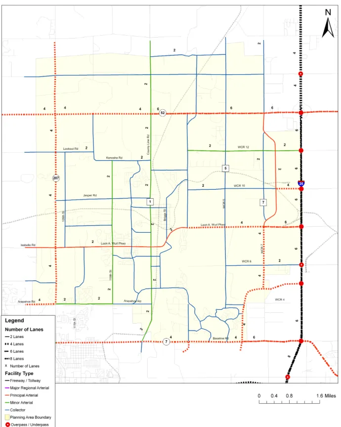
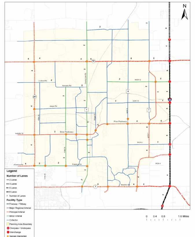
Roadway System Plan ... 11-5
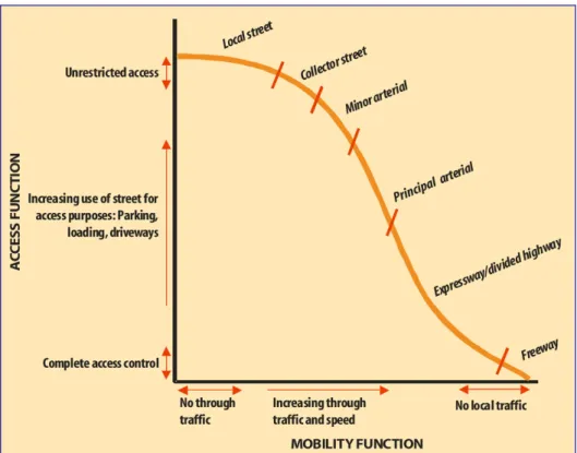
Roadway Functional Classification and Design Standards ... 11-9
Transit Issues ... 11-15
C
HAPTER
12:
H
OUSING
AND
N
EIGHBORHOODS
Background and Intent ... 12-1
Goals and Policies ... 12-1
C
HAPTER
13:
C
OMMUNITY
C
HARACTER
AND
D
ESIGN
Background and Intent ... 13-1
Goals and Policies ... 13-1
C
HAPTER
14:
E
CONOMIC
D
EVELOPMENT
Background and Intent ... 14-1
Goals and Policies ... 14-1
C
HAPTER
15:
A
CTION
P
LAN
Summary of Priority Actions ... 15-1
Town of Erie Comprehensive Plan – 2015 Update
Chapter 1: Introduction
PURPOSE OF THE COMPREHENSIVE PLAN
The Town of Erie Comprehensive Plan is an officially adopted
advisory document that outlines the community’s vision and
goals for the future and provides guidance for elected and
appointed officials in making choices regarding the long-range
needs of the community. The written goals and guiding
principles, policies, and recommendations of the Comprehensive
Plan, along with the Future Land Use map, provide guidance for
decisions affecting growth and annexation, the use and
development of land, preservation of open space and the
expansion of public facilities and services. The policy
recommendations and maps contained in the Comprehensive
Plan are interrelated and should not be used independently from
one another.
WHY UPDATE THE PLAN?
Erie’s Comprehensive Plan was last updated in 2005. Since that time the community, along with many of its Front Range neighbors, has experienced considerable growth. Since the plan was last updated in 2005, the population has grown by more than 6,500 people and nearly 2,350 new residential dwelling units. In addition to residential growth, the Town has started to see some commercial growth at Erie Commons, Coal Creek Center, and Vista Ridge. Community facilities including the library, community center, community park, new schools, and new raw water pipeline and pump station are also recent improvements in the Town.
While this updated plan carries forward the majority of the content from the 2005 effort, it provides more focused guidance for the Town as the community continues to grow. The updated Plan also encourages a more flexible approach to future development that will promote a more balance mix of uses for the community.
PLANNING AREA
The Planning Area, which includes lands within the “sphere of influence” but outside the incorporated area, covers a total of 48 square miles, extending from State Highway 7 on the south to north of highway 52, and between U.S. 287 on the west to Interstate 25 on the east. Of these 48 miles, approximately 19 square miles have been incorporated into the Town.
Town of Erie Comprehensive Plan – 2015 Update
HISTORIC CONTEXT
The original plat for Erie was filed in 1871, following establishment of the Briggs Mine, the first commercial coal mine in Weld County. Until that time, surface coal had been delivered to its customers by horse and wagon. It was also in 1871 that the Union Pacific Railroad extended a spur westward from Brighton on its main line between Denver and Cheyenne. Coal from the Erie deposits was needed to fuel their huge steam locomotives. The Boulder Valley Railroad, as it was called then, opened up the northern coal fields for
development. Soon coal from Erie mines was being shipped by rail to markets in Denver and as far east as Kansas City. The Town of Erie was incorporated in 1874.
PUBLIC INVOLVEMENT
Public involvement is a crucial component of any Comprehensive Plan development process. In 2005 the development of the Comprehensive Plan involved a substantial public involvement effort that entailed numerous Advisory Committee meetings, community workshops, and leadership updates. Because the 2015 update was a more focused effort, public involvement was targeted at the following efforts:
Town Board and Planning Commission Updates
Community Event and Public Hearings
T
OWNB
OARD ANDP
LANNINGC
OMMISSIONU
PDATESStaff provided regular updates at joint meetings of the Town Board and Planning Commission throughout the Planning Process. Officials were given updates on the progress of the plan development and had an opportunity to discuss and provide direction on key planning issues. Strong communication between staff and Town officials assisted in the development of a plan with the necessary support to be successfully adopted and implemented.
C
OMMUNITYE
VENT ANDP
UBLICH
EARINGSDuring the planning process the planning team attended the Town Fair to share information on the plan and seek feedback on the key ideas under consideration. Notification letters were mailed to property owners to alert them about the proposed updates to the Plan and the scheduled public hearings. Two public hearings were held with the Town Board and Planning Commission to review and discuss the changes in the Plan.
CHANGES IN THIS PLAN
The 2005 Comprehensive Plan Update replaced the 1996 and 1999 plans with significant changes from these previous versions in both form and content. This 2015 update retains the overall organization and majority of the content of the 2005 plan, although the key changes are summarized below.
FUTURE LAND USE PLAN
The Future Land Use Plan Map and corresponding land use
categories were updated to reflect the desired new directions for the community, particularly in the area near Interstate 25.
Town of Erie Comprehensive Plan – 2015 Update POLICIES AND PLAN IMPLEMENTATION
This plan includes an updated Action Plan that described detailed actions and policies to be pursued as a means of accomplishing the goals.
PLAN ORGANIZATION
The Comprehensive Plan is organized into the following chapters.
Chapter 1—Introduction
Chapter 2—Vision and Guiding Principles
Chapter 3—Community Building Blocks
Chapter 4—Land Use
Chapter 5—Growth Management
Chapter 6—Natural Resources and Environment
Chapter 7—Parks, Recreation, and Trails
Chapter 8—Open Space
Chapter 9—Public Facilities and Services
Chapter 10—Regional Coordination
Chapter 11—Transportation and Mobility
Chapter 12—Housing and Neighborhoods
Chapter 13—Community Character and Design
Chapter 14—Economic Development
Chapter 15—Action Plan
Appendix A: Existing Conditions Summary
Appendix B: Issues Summary
Appendix C: Traffic Modeling
Appendix D: Glossary of Terms
HOW TO USE THE PLAN
Erie’s Comprehensive Plan is comprised of two distinct, but interrelated components, which together serve to guide the location, type, and characteristics of future development within the Planning Area. These components include:
The Future Land Use Plan Map, which provides broad guidelines for land use patterns within the Town’s Planning Area; and
The Comprehensive Plan document which contains goals, guiding principles, and policies that provide detailed guidance on the specific land uses that will occur in each area.
The Future Land Use Map is purposefully general in nature to allow for flexibility in the specific location and extent of each land use on a development-by-development basis and should be used in conjunction with the goals and policies contained in this Plan. As such, land use “bubbles” in undeveloped areas of the Planning Area are expected to be varied to respond to site
Town of Erie Comprehensive Plan – 2015 Update
specific features and the surrounding development context according to the guidelines listed below.
G
UIDELINES FORA
DJUSTMENT OFL
ANDU
SEP
LANM
APThe following guidelines should be used to help guide the refinement of Future Land Use Map “bubbles” as development occurs. The guidelines should be referred to by applicants prior to the preparation of a development submittal and by Town staff, elected and appointed officials as part of the
development review process.
Proposed adjustments to the boundaries of a particular land use should demonstrate that the following criteria can be met:
Average densities of the applicable “bubbles” depicted on the Future Land Use Map are maintained within the proposed land use pattern;
The location of proposed higher density uses is appropriate based on the surrounding development context and appropriate transitions to adjacent land uses can be provided according to the goals and policies contained in this Plan; and
Proposed distribution and organization of uses on the site are consistent with the Town’s Vision and Community Building Blocks, as contained in this Plan.
A
REAS OFS
PECIALC
ONSIDERATIONThree areas are identified on the Future Land Use Map as Areas of Special
Consideration. These areas have been identified to acknowledge their
importance as major community gateways and to acknowledge that an increased level of review and consideration will need to be placed on development proposals occurring within the areas identified, in terms of their uses and design. Specific policies for the areas defined along Highway 52, Erie Parkway and County Line Road/Arapahoe Road are contained in Chapter 13, Community Character and Design and are also referenced in applicable sections of the Land Use Policies contained in this chapter. While guidance is also provided on other gateway corridors, the Areas of Special Consideration are largely undeveloped today—giving the community the ability to establish a unified character prior to development occurring in many cases.
The policies provide guidance on the following:
Erie Parkway—landscape buffers, pedestrian connections, view
protection, parking design and location, building orientation, fencing, and signage;
Highway 52—Clustering of commercial development in compact
activity centers, broad setbacks for residential development, and fencing;
County Line Road/Arapahoe Road—Landscape buffers, pedestrian
connections, view protection, parking design and location,
compatibility with airport flight patterns, building orientation, fencing, signage, and transitions between urban intensity uses and existing rural residential neighborhoods and open space areas.
Town of Erie Comprehensive Plan – 2015 Update
While the policies will serve as a guide, it may also be appropriate for the Town to establish more detailed land use, landscape, and urban design concept plans to establish a unified character for these important areas.
PLAN AMENDMENT PROCEDURES
The Town of Erie Comprehensive Plan is a policy document used to guide decision-making within the Town. For the plan to function over time, it must be able to be periodically reviewed and updated, in order to respond to
significant trends or changes in the economic, physical, social, or political conditions of the area.
Revisions to the Plan will be conducted according to two distinct and different procedures: Plan Update, and Plan Amendments. A Plan Update should occur at intervals of approximately every five years. The purpose of a Plan Update is to re-evaluate the goals, policies, and actions contained within the Plan, noting those that should be changed and those that should be removed, and develop new policies if necessary, to make sure that the Plan is being
effective.
A separate process has been established for amendments to the Plan, and may be performed on a yearly basis or as needed. Plan Amendments may include revisions to one or more sections of the Comprehensive Plan as a result of adoption of subarea plans or a specific issue/policy plan, or by directive from the Town Board. Plan Amendments may include changes to the Future Land Use Plan map. Other amendments may be as small as correcting text or map errors. The process for making these amendments are described below.
P
LANU
PDATEP
ROCESSIt is intended that an update of the Comprehensive Plan take place at least every five (5) years unless otherwise directed by the Town Board. In making a determination of when an update should be initiated, a prime consideration should include what changes have occurred since the Plan was last updated. These changes may be in the economy or the environment, housing
affordability, transportation system changes, local priorities or issues, projected growth, etc. A Plan Update will include a thorough re-evaluation of the vision, goals, and policies contained within the Plan, noting those that should be changed and those that should be removed, and develop new policies if necessary, to make sure that the Plan is being effective. A Plan Update will also include a thorough review of the validity of all information contained within the Plan and should include extensive opportunities for involvement by the public, boards and commissions, elected and appointed officials, town staff, and other affected interests.
The Planning Commission and Town Board shall then approve, approve with conditions, or deny the update based on its consideration of the
recommendations from staff, boards and commissions, and evidence from public hearings.
P
LANA
MENDMENTP
ROCESS ANDP
ROCEDUREAmendment requests may be initiated by a resident of the Town, by a property owner, by the Planning Commission, or by the Town Board. All Plan Amendments shall be considered by the Planning Commission and Town Board. The Planning Commission and Town Board shall then approve, approve with conditions, or deny the amendment based on its consideration of the recommendations and evidence from the public hearings.
Town of Erie Comprehensive Plan – 2015 Update
P
LANA
MENDMENTP
ROCEDUREThe following is the common review procedure for Comprehensive Plan amendment requests and shall apply to all amendment requests unless an exception to the common procedure is granted by the Community Development Director after reviewing the applicant’s written request.
PA1.1- STEP 1 - PRE-APPLICATION CONFERENCE
A Comprehensive Plan amendment request shall be presented to Town Staff by the applicant at a Pre-Application conference. This conference provides an opportunity for an informal evaluation of the applicant’s proposal and to familiarize the applicant with issues that may affect the proposal.
This informal evaluation by staff provided at the conference is not binding upon the applicant or the Town, but are intended to serve as a guide to the applicant in making the application and advising the applicant in advance of the formal application of issues which may be presented to the appropriate decision-making body.
PA1.2 – STEP 2 - OPTIONAL PLANNING COMMISSION PRE-APPLICATION CONFERENCE
At the applicant’s request, the Community Development Director may grant an application conference, which shall be in addition to the required Pre-Application conference with the Community Development Director.
PA1.3 – STEP 3 - APPLICATION SUBMITTAL
See the Comprehensive Plan Amendment User’s Guide for submittal requirements.
PA1.4 – STEP 4 – DETERMINATION OF APPLICATION COMPLETENESS
After receipt of the amendment application, the Community Development Director shall determine whether the application is complete and ready for review. An application will be considered complete if it is submitted in the required form, includes all information and supporting materials specified in the User’s Guide, and is accompanied by the applicable fee. The
determination of completeness shall not be determined based upon the perceived merits of the amendment request.
If the application is determined to be incomplete, the Community
Development Director shall provide notice to the applicant along with the application’s deficiencies. No further processing of an incomplete application shall occur until the deficiencies are corrected in a re-submittal.
PA1.5 – STEP 5 - APPLICATION REVIEW AND REPORT
After determining that the amendment application is complete, Town staff shall process the application in the following manner:
PA1.5.A – Application Review
Staff shall notify the applicant of the number of copies of the application and submittal information required for distribution to Town staff and when applicable to outside referral agencies.
Staff and when applicable, referral agencies shall comment within 21 days of receiving a complete submittal unless an extension is granted of no more than 30 additional days is agreed to by the Community Development Director.
Town of Erie Comprehensive Plan – 2015 Update PA1.5.B – Resolution of Issues
Community Development staff shall compile and review all comments and provide a copy of all comments to the applicant. The applicant shall resolve outstanding issues to the maximum extent practicable
PA 1.5.C - Staff Report
Community Development staff shall prepare a Staff Report. The Staff Report shall indicate whether, in the opinion of the staff, the proposed amendment complies with all applicable Approval Criteria listed in Step 9. The Staff Report shall be made available for inspection and copying by the applicant and the public prior to the scheduled public hearing on the proposed amendment.
PA1.6 – STEP 6 – PUBLISHED NOTICE
Published notice of a required Public Hearing shall; (1) identify the date, time, and place of the public hearing, (2) if applicable, describe the property involved in the application by street address or by legal description and nearest cross street; (3) describe the nature, scope, and purpose of the proposed action; and (4) indicate that interested parties may appear at the hearing and speak on the matter.
The Community Development Director shall cause a notice to be published in a newspaper having general circulation in the area. The notice shall be published at least 15 days before the scheduled hearing date. In computing such period, the day of posting shall not be counted, but the day of the hearing shall be counted.
PA1.7 – STEP 7 – PUBLIC HEARING
A public hearing shall be conducted according to the following procedures:
1.7.A -Rights of All Persons
Any person may appear at a public hearing and submit evidence, either individually or as a representative of a person or an organization. Each person who appears at a public hearing shall state their name, address and, if appearing on behalf of a person or organization, the name and mailing address of the person or organization being represented.
1.7.B - Exclusion of Testimony
The decision-maker conducting the public hearing may exclude testimony or evidence that it finds to be irrelevant, immaterial, or unduly repetitious.
1.7.C - Continuance of Public Hearing
The decision-maker conducting the public hearing may, on its own motion or at the request of any person, continue the public hearing to a fixed date, time and place. All continuances shall be granted at the discretion of the body conducting the public hearing. Re-publication and re-noticing of continued public hearings shall be at the discretion of the body conducting the public hearing.
1.7.D - Court Reporter
The Community Development Director shall have the discretionary authority to require the presence of a court reporter at any public hearing
Town of Erie Comprehensive Plan – 2015 Update
required by this Chapter and to assess the cost of such reporter to the applicant.
1.7.E - Order of Proceedings at Public Hearing
The order of the proceedings at the public hearing shall be as follows:
1.7.E.1 - Opening of Public Hearing
The public hearing shall be formally opened by the Town body conducting the public hearing.
1.7.E.2 - Staff Report Presented
The Community Development Director or designee shall present a narrative and/or graphic description of the development application. The Community Development Director or designee shall present a Staff Report which includes a written recommendation. This recommendation shall address each standard required to be considered by this Code prior to approval of the development application.
1.7.E.3 - Applicant Presentation
The applicant shall present any relevant information the applicant deems appropriate. Copies of all writings or other exhibits that the applicant wishes the decision maker to consider must be submitted to the Community Development Director no less than five working days before the public hearing.
1.7.E.4 - Public Testimony
Relevant public testimony shall be heard.
1.7.E.5 - Applicant Response
The applicant may respond to any testimony or evidence presented by the public.
1.7.E.6 - Staff Response
The Community Development Director, the Town Attorney, and any other staff member may respond to any statement made or evidence presented by the applicant or the public.
1.7.E.7 - Close of Hearing
After consideration of the development application, the Staff Report, any additional written and/or exhibit materials submitted, and the evidence from the public hearing, the decision-maker shall close the public hearing.
PA1.8 – STEP 8 – DECISION AND FINDINGS
1.8.A – Planning Commission Review & Recommendation
After consideration of the proposed amendment, the staff report, comments received from other reviewers (if applicable), and the evidence from the public hearing, the Planning Commission shall make a recommendation to the Board of Trustees to approve or deny the application based on its compliance with the applicable approval criteria, as described in Step 9 below.
Town of Erie Comprehensive Plan – 2015 Update
All decisions shall include a clear statement of approval or denial, whichever is appropriate, and written findings of fact with reference to the applicable approval criteria of Step 9.
1.8.B – Board of Trustees Action
After reviewing the reports and recommendations of the Community Development Director and the Planning Commission, the Board of Trustees shall vote to approve, approve with amendments, or deny the application, based on its compliance with the applicable approval criteria, as described in Step 9 below.
The Board of Trustees also may refer the application back to the Planning Commission for further consideration.
1.8.B.1 – Records of Amendments
A record of amendments to the Comprehensive Plan shall be maintained by the Community Development Department.
1.8.B.2 - Close of Hearing
Following denial of an application, no new application for the same or substantially the same amendment shall be accepted within one year of the date of denial. The waiting period required herein, may be waived in an individual case, for good cause shown, by the affirmative vote of three-fourths of the members of the Board of Trustees.
PA1.9 – STEP 9 – APPROVAL CRITERIA
A Comprehensive Plan amendment may be approved by the Planning commission and the Town Board if specific findings are made that the following approval criteria have been met:
1. The existing Comprehensive Plan and/or any related element thereof is in need of the proposed amendment;
2. The proposed amendment is compatible with the surrounding area, and the goals and policies of the Plan;
3. The proposed amendment will have no major negative impacts on transportation, services, and facilities;
4. The proposed amendment will have minimal effect on service provision, including adequacy or availability of urban facilities and services, and is compatible with existing and planned service provision;
5. The proposed amendment, if for an area that is outside of the Town’s current municipal boundaries, is consistent with the Town’s ability to annex the property;
6. Strict adherence to the Plan would result in a situation neither intended nor in keeping with other key elements and policies of the Plan; and 7. The proposed plan amendment will promote the public welfare and will
be consistent with the goals and policies of the Comprehensive Plan and the elements thereof.
Town of Erie Comprehensive Plan – 2015 Update
Chapter 2: Vision and
Guiding Principles
A vision is a statement of the kind of place that residents, business
owners, and community leaders want the Town to become in the future.
This Vision describes the community’s values and aspirations for the
Town.
The process of identifying community values for the Comprehensive Plan
started with the Erie Stakeholders Assessment Process (ESAP), a
Community Visioning Process that was completed in 2001. The planning
team translated the values and desires from ESAP, along with prior goal
statements from the 1996 and 1999 Comprehensive Plans and an
analysis of current issues and opportunities, into a vision statement and
supporting goals that could be achieved through specific actions. It is
intended to convey the general direction and vision desired by the
community.
VISION
The Vision is based on the premise that the health of the Town and
the quality of life of its residents are not dependent on any one
factor. The underlying premise is an understanding that the Town
must seek a balance between environmental, economic and
community/social considerations. Each of these components is
interrelated and essential to the continued health and
sustainability of the community. Viewed together, they provide a
balanced and flexible overall basis for formulating the Town’s
Comprehensive Plan:
Erie is a community which recognizes the importance of conserving and
enhancing its historic small town character, the roots from which it grew,
preserving the natural environment in which it resides; a caring community
which offers its residents an environment in which to seek a high quality of life;
a balanced community with a diverse range of housing, employment,
educational, shopping and recreational opportunities; and a vital community
which provides financial and social support for quality of life programs.
Town of Erie Comprehensive Plan – 2015 Update
GUIDING PRINCIPLES
The following statements describe the community’s aspirations
and set the direction for the Comprehensive Plan. They
demonstrate the general ideals to be sought for the Town within its
planning area over the next 20 years, building on the Vision
established for the community.
Our Vision includes the following key principles:
A Coordinated and Efficient Pattern of Growth
The Town will have a compact pattern that encourages urban
growth to locate within the Planning Area Boundary, fosters the
efficient provision of infrastructure and services, and balances
development and conservation of the natural environment.
Quality Design and Development
Erie will promote a high standard of design for all new
development, renovation, and rehabilitation to reinforce and
enhance its unique nature for residential neighborhoods, public
places, and commercial businesses.
Overall Economic Vitality
The Town will promote a healthy, thriving economy that provides
opportunities for quality employment with livable wages for its
residents.
Downtown Vitality
The Town considers the maintenance and enhancement and
expansion as appropriate of Old Town’s vitality to be important to
the health and well-being of the community as a whole. The plan
promotes development and continued enhancement of this core
community area as the “center” of the community.
A Comprehensive, Integrated Transportation System
Erie has a safe, efficient, and innovative transportation system that
reduces neighborhood isolation and promotes a sense of
community by connecting all areas of town, accommodates
various modes of public and private transit, and facilitates travel to
regional centers.
Stewardship of the Natural Environment
The Town will identify and conserve its natural, scenic, and
environmentally sensitive areas including important wildlife habitat,
waterways, and visually sensitive areas. Erie will strive to be a
clean, sustainable, environmentally-friendly town.
Town of Erie Comprehensive Plan – 2015 Update
Trails, Parks and Recreation Opportunities
The Town will provide a diverse range of recreational opportunities
to include facilities and programming for all ages and varying
interests, both passive and active. Trails, parks, and recreation
opportunities will be connected with and integrate open space
into and between neighborhoods and other areas of the
community.
Protected Lands Program
Lands that are permanently protected as open space will be used
to maintain the small town atmosphere that has made Erie an
attractive place. Open space will serve a variety of functions,
including:
•
Buffering Erie from other towns and cities and shaping growth;
•
Creating view corridors to enable residents to see mountains,
plains, and agricultural areas rather than uninterrupted housing
and commercial development;
•
Preserving agricultural lands, keeping them in agricultural
production;
•
Restoring riparian areas and other areas of natural habitat;
•
Protecting significant archeological and cultural resources;
•
Preserving native plant and animal habitat and travel corridors
for wildlife;
•
Providing areas for passive recreation that emphasizes
enjoyment of nature; and
•
Distinguishing and linking neighborhoods and other activity
areas within Erie through a system of continuous, connected
open lands and trails.
Balanced Land Use Mix
The Town will work to diversify and balance the mix of land uses as
the Town grows. Particular emphasis will be placed on enhancing
the local economic base to provide employment opportunities for
residents, seeking to achieve a better balance as a place to work
as well as live. In so doing, the community will seek a balance
between the enhancement of Old Town’s vitality and other
existing areas of the community and the identification of
opportunities for commercial and employment in outlying areas.
Stable, Cohesive Neighborhoods Offering a Variety of Housing Types
The Town will promote new neighborhoods that contain a mix of
land uses and diversified housing options that meet the varying
needs of its residents, including single family, attached homes
(duplexes, townhomes), multifamily dwellings, and housing
included as part of mixed-use developments. The Town will work
to maintain the quality and character of established
Town of Erie Comprehensive Plan – 2015 Update
neighborhoods and ensure that infill and redevelopment is
designed in a manner that minimizes impacts on existing
neighborhoods, including rural neighborhoods in the Planning
Area. New housing and neighborhoods should be appropriate in
size, scale, design and use. New housing areas should be located
where residents will have access to the full range of infrastructure,
facilities and services that are needed for healthy, livable
neighborhoods.
Provide Infrastructure and Public Services Efficiently and Equitably
Erie will coordinate future development and/or provision of capital
facility projects and infrastructure, including water, wastewater,
fire protection, emergency management services, police
protection, schools, parks, and other utilities that affect the quality
of life and economic stability of the community.
Town of Erie Comprehensive Plan – 2015 Update
Chapter 3: Community
Building Blocks
During the Planning Process a number of distinct
themes or “community building blocks” emerged
as being fundamental to the ultimate success of the
Plan. While each of these themes is addressed at
a broad level within the Vision and Guiding
Principles outlined in the previous chapter, a
discussion of their role in the intended outcome and
application of the Comprehensive Plan is provided
below. This discussion is intended to supplement
the goals and policies contained in the Plan by
providing a more focused explanation of the key
principles underlying each theme and the Town’s
objectives in applying them to future development
proposals.
Erie’s five Community Building Blocks include:
Neighborhood Emphasis;
Mixed-Use Development;
Gateways and Corridors;
Rural Character; and
Economic Sustainability.
NEIGHBORHOOD EMPHASIS
For most of its years Erie consisted of a single, compact neighborhood in what is referred to today as Old Town. Residents of Old Town were able to (and are still able to today, in some cases) walk to meet many of their daily needs and even go to work. In recent years, the Town’s compact feel has begun to change as new development has sprung up in outlying areas of the Town’s Planning Area, far from its historic center and both visually and physically detached from the rest of the community.
The goals and polices contained in the Plan are built around Erie’s desire to distinguish itself as a community of free-standing, but integrated
neighborhoods, linked together—and to Old Town—by an interconnected
network of pedestrian pathways, trails, and open space.
The design of Erie’s future neighborhoods is a major focus of the Comprehensive Plan. Although their scale and composition will vary from location to location, new neighborhoods should be designed using a common set of principles that include:
A mix of uses and housing types
An interconnected network of streets, open space, and trails;
The preservation of natural features;
Clear activity centers; and
Town of Erie Comprehensive Plan – 2015 Update
The following principles embody the community’s vision for its future neighborhoods:
M
IX OFH
OUSINGT
YPES Neighborhoods should contain a variety of housing types (single-family detached, single-(single-family attached, townhomes, apartments, etc.) to provide a more diverse selection of lifestyles and housing pricing for Erie residents.
Neighborhoods should incorporate a variety of housing models and façade treatments to create visual interest and a more inviting pedestrian environment.
C
ONNECTIVITY Neighborhoods should be connected to adjacent neighborhoods and the surrounding community with direct roadway and pedestrian connections and open space.
Isolating neighborhoods with walls and gates should be avoided.
P
ARKS ANDO
PENS
PACE Neighborhoods should include or be easily accessible to a range of parks and open space amenities to appeal to residents of all ages and abilities.
Town of Erie Comprehensive Plan – 2015 Update
A
CTIVITYC
ENTERS Each neighborhood should include an activity center for its residents. Activity centers may include a mix of commercial development, parks, open space, and other community facilities, where
appropriate, to serve the needs of neighborhood residents. Larger, commercially-oriented activity centers may serve more than one neighborhood.
Activity centers should be designed to be connected to adjacent neighborhoods with streets and sidewalks.
P
RESERVATION OFN
ATURALF
EATURES Neighborhoods should be planned to maximize the preservation of natural features, such as drainages, significant trees, topographic features, and other features.
D
ISTINCTI
DENTITY Neighborhoods should be planned to incorporate unique
characteristics that serve as identifiers for residents, such as such as distinct streetscape elements, architectural styles, and neighborhood center features. However, neighborhoods should also incorporate features that visually and physically link them to the larger community and the Town of Erie. This may occur through naming, street graphics (i.e. incorporating the Town of Erie logo), trail connections, or other features that serve to create a common link between the Town’s many neighborhoods.
MIXED-USE DEVELOPMENT
The Land Use Plan (Chapter 4) includes a new land use category to accommodate Mixed-Use Development. At a general level these mixed-use areas are similar in that they are intended to contain a variety of activities, such as offices, retail, and multiple housing types. They differ, however, in that the scale and configuration of development will vary by its location and development context (i.e., Old Town infill/redevelopment vs. new development). Common principles for mixed-use development include:
M
IX OFU
SES Depending upon their location and scale, primary uses for mixed-use development areas may include commercial, office, retail, and/or housing. However, more active uses such as retail and commercial should be placed at the ground level to provide pedestrian interest. Where activity uses are limited, they should be concentrated at key intersections or near major public spaces to maximize public exposure and increased activity levels.
Both vertical (stacked) and horizontal (side-by-side) mixed-use is encouraged in Erie provided it is well-connected to surrounding neighborhoods.
Vertical mixed-use refers to the integration of two or more land use types within a building, occurring on different floors, one of which is residential. A typical example of a vertical mixed use building would incorporate active uses, such as stores, offices, and restaurants, at the street level and residential or office uses on the upper floors.
Neighborhood scale mixed-use with retail, office, and residential uses in a pedestrian-friendly setting.
Town of Erie Comprehensive Plan – 2015 Update
Horizontal mixed-use refers to a pattern where several types of uses or buildings, together with residential, are included, as part of a
cohesive development in proximity to each other – but each building would contain its own separate use. They would be designed as a set of coordinated uses, with common parking areas, strong pedestrian connections, and similar design features, but would contain separate uses in each building.
Mixed-use development should also incorporate schools, parks, and open space, and other community facilities, where appropriate, to serve the needs of neighborhood residents.
D
ESIGN FORP
EDESTRIANS/M
ULTI-M
ODALA
CCESS Site plan and building designs should be pedestrian-oriented by incorporating wide and detached sidewalks and paths, seating, low-level lighting, and signs that are scaled for pedestrians in high activity areas.
Mixed-use development should incorporate walkable blocks (typically less than 400 feet in length) with frequent pedestrian connections to adjacent neighborhoods.
Provide for interconnected block and street patterns.
Provide access to the arterial street system and provide locations for future transit stops.
Provide connections to parks, trails, and open space.
I
NCLUDEH
OUSING Incorporating housing into mixed-use development areas is strongly encouraged, either in a vertical (stacked) configuration or as an adjacent, but well-integrated use.
High density housing should be concentrated within or near activity centers to provide opportunities for residents to walk to shops, transit, services, and jobs.
In larger mixed-use developments, housing (apartments, lofts, or townhomes) can also be used to provide transitions to surrounding neighborhoods.
T
RANSITIONS FROM ANDC
ONNECTIONS TOS
URROUNDINGA
REAS In the Old Town area, mixed-use developments should be used to help revitalize major corridors into the downtown core (Briggs Street and Cheesman) and should provide transitions to surrounding neighborhoods.
Larger mixed-use developments should be designed in conjunction with surrounding neighborhoods where possible, providing direct connections and strong development relationships.
(Top) Horizontal mixed-use integrated with surrounding neighborhood. (Bottom) Vertical mixed-use incorporating high density housing above retail shops.
Townhomes designed to provide a more gradual transition between a mixed-use center and a single family
Town of Erie Comprehensive Plan – 2015 Update
GATEWAYS AND CORRIDORS
Erie has an opportunity to establish distinct entryways to the community along its major gateway corridors. This opportunity is most evident along Erie Parkway and Highway 52, where development to date has been limited, but is anticipated on the Future Land Use Map. Other gateway corridors, including County Line Road (North and South), Baseline Road (Hwy 7), and Arapahoe Road, have a character that is fairly well established either through existing open space or existing development patterns.
Future development in any of the Town’s gateway corridors should be designed with the following principles in mind:
V
IEWC
ORRIDORS Development setbacks should be established along gateway corridors to preserve site lines and reduce visual impacts of development.
Signage along the Town’s gateway corridors should be limited to low profile monument signs designed as part of a larger development scheme and should be consolidated for larger developments to minimize visual clutter.
D
EVELOPMENTQ
UALITY/R
ELATIONSHIP TO THEC
ORRIDOR Development setbacks should be landscaped to buffer
development, to help preserve key view corridors, to provide an inviting environment for pedestrians, and to establish a consistent character.
Development should be oriented towards the gateway corridor, providing a high level of architectural detailing and entrances for pedestrians.
Buildings located at major intersections should be brought closer to the street to anchor corners and to help form a gateway into adjoining neighborhoods.
Parking, loading areas, and other unsightly uses should be located away from the gateway corridor where possible and should be fully screened using a combination of landscaping, berming, and/or decorative fencing.
A
CCESSM
ANAGEMENT As development occurs along Erie’s major gateway corridors, centralized access points will need to be established to manage traffic circulation and to protect the character of the corridor.
(Top) Example of gateway corridor treatment. (Bottom) Conceptual diagram of primary gateway corridor development setbacks, multi-use path, and landscaping.
Town of Erie Comprehensive Plan – 2015 Update
RURAL CHARACTER
Erie’s rural character—one of the many benefits of its agricultural heritage—is highly valued by the community. Although the community’s character will evolve and become less rural as it continues to grow, maintaining visual breaks in development and providing a visual separation between individual neighborhoods is a key aspect of the Plan’s Vision. This will be particularly important east of County Line Road, where large tracts of undeveloped land remain and where multiple rural residential developments already exist in the Weld County. Maintaining ongoing efforts to increase the community’s open space network will be a major factor. The Plan encourages the protection of this character using the following principles:
O
PENS
PACE Individual neighborhoods should be designed to provide logical open spaces that serve the immediate
neighborhood as well as provide linkages to the broader open space network of the community.
Design lots within a clustered development to abut or link directly to designated open space within the development.
Locate large blocks of contiguous open space that link to adjacent open lands.
ECONOMIC SUSTAINABILITY
Employment opportunities and commercial services within Erie are currently somewhat limited. The Town recognizes that expanding opportunities for employment and commercial development is important to enhance tax revenues generated in the Town as well to reduce the need for residents to travel to neighboring communities to work, shop, and meet other daily needs. The Town also recognizes that attracting significant commercial and
employment development will be challenging given the high volume of competition from neighboring Front Range communities.
In light of these challenges, the Plan seeks to achieve build economic sustainability over time by placing an emphasis on each of the community building blocks highlighted in this Chapter:
the creation of high-quality residential neighborhoods;
encouraging a more mixed-use pattern of development that allows the integration of commercial and employment uses on a smaller scale;
establishing a high quality pattern of development focused in activity centers and along the community’s major gateway corridors; and protecting the community’s rural character as a unique aspect of its
appeal.
Together, these objectives will allow Erie to grow into a community that will be attractive to future commercial and employment development when opportunities arise.
Town of Erie Comprehensive Plan – 2015 Update
Chapter 4: Land Use
This chapter provides a series of land use goals and policies that support
these Community Building Blocks and provide specific direction for
property owners, elected and appointed community leaders, and Town
staff and administrators in making decisions regarding the location and
design of development within the Planning Area. The chapter also
provides a land use summary table that defines the range of size or
density, primary and secondary uses, and defining characteristics for
each land use identified on the Future Land Use Map. This Chapter
should be used in conjunction with the Future Land Use Map and with
the other goals and policies contained in this Plan.
Goal #1: Balanced Land Use Mix
Plan for a balanced mix of commercial and residential land uses in Erie.
RESIDENTIAL
The Future Land Use Map identifies four residential use designations:
Rural Residential, Low Density Residential, Medium Density
Residential, and High Density Residential. Specific policies are
provided for each of the categories, along with a set of general policies
that apply to the three urban residential categories. The policies
represent a shift towards a more flexible, neighborhood-oriented
approach to residential development than is typical of more recent
development patterns in the community. The intent is to encourage new
neighborhoods to incorporate a diversity of housing (in terms of housing
type, density, and price point) and an array of services, such as
shopping, schools, and parks that can meet many residents’ day-to-day
needs within a close proximity. Due to Erie’s rolling topography and
natural features and current pattern of development, many new
neighborhoods will be somewhat isolated physically for the foreseeable
future. However, each neighborhood will be linked to adjoining
neighborhoods and Old Town through a comprehensive network of trails
and open space corridors. This network will provide opportunities for
residents to walk or bicycle to nearby services and gathering places and
reduce the need for cross-town vehicle trips. Opportunities for
neighborhoods that are predominately single-family will continue to
exist, but will be driven more by market demand and specific
development master plans.
A balanced mix of commercial, residential, and employment uses is encouraged.
Town of Erie Comprehensive Plan – 2015 Update
R
URALR
ESIDENTIALP
OLICIES:
RR 1.1—CHARACTERISTICSThe Rural Residential designation provides a rural setting for large-lot, very low-density single-family housing. Lot sizes and layouts will be dependent upon topographical constraints and hilly terrain located in some areas of the community. In some cases, large portions of a lot may remain in an undeveloped state, reinforcing the rural character of this development pattern. Existing Rural Residential development in Boulder and Weld Counties typically relies on individual sewage treatment systems and either individual water wells or rural water districts. New Rural Residential developments located within the Town’s incorporated area will be required to be served by municipal water and wastewater service. Single lot developments will be required to be served by municipal water and wastewater service if within 400 feet of a sewer line.
RR 1.2—DENSITY RANGE
Homes will typically occur at densities of between 0-2 dwelling units per acre. However, gross densities will not typically exceed 1 dwelling unit/acre. Lots in many existing rural subdivisions in the Planning Area exceed 1 acre.
RR 1.3—LOCATION
Rural Residential neighborhoods will typically be located at the fringe of urban development, near existing rural neighborhoods, or in areas with steeper terrain or other natural features unsuitable for urban residential development. In some cases, they will serve as a transition between more intense urban neighborhoods and natural features to be protected or existing rural neighborhoods.
RR 1.4—OPEN SPACE
Open space should provide strong visual and physical connections to the surrounding open space and trails network—both existing and planned.
RR 1.5—ROADWAY DESIGN
Access road and driveway configurations should follow the natural contours of topographic features to minimize slope disturbances, maximize scenic views, and conserve natural features.
RR 1.6—LANDFILL RELATIONSHIPS
Rural Residential neighborhoods that abut an existing or future landfill site will be encouraged to cluster homes away from the landfill boundary, creating an open space buffer between the two uses.
U
RBANR
ESIDENTIALP
OLICIES—A
LL CATEGORIES:
UR-1.1—VARIETY OF HOUSING TYPESThe incorporation of a variety of housing types, models, sizes, lot sizes, lot configurations, and price ranges in new neighborhoods will be strongly encouraged to provide expanded housing options for Erie residents.
Incorporating a mix of housing types at both the neighborhood scale and the block scale will be encouraged to create varied and interesting streetscapes and to encourage a diverse community.
Town of Erie Comprehensive Plan – 2015 Update UR 1.2—NEIGHBORHOOD EMPHASIS
The Town will encourage urban residential development to be focused in distinct neighborhoods that contain a variety of housing types to support the housing needs of a diverse population. The integration of neighborhood commercial centers and other complementary uses that are of a scale and character that complements the surrounding neighborhood will also be encouraged.
UR 1.3—STREET PATTERNS
Urban neighborhoods should be organized around a system of
interconnected collector and local streets, as traditionally found in Erie’s Old Town neighborhood. Detached sidewalks and pedestrian and bicycle pathways will also be encouraged. Neighborhoods located adjacent to future development areas shall provide opportunities for future roadway extensions. Cul-de-sacs and other dead end streets and alleys are discouraged unless necessitated by the natural or built constraints of the development site, in order to encourage connectivity between
neighborhoods. Where cul-de-sacs are used, pedestrian connections shall be provided between streets and adjacent open space areas, trails, or other common features to promote neighborhood connectivity.
UR 1.4— URBAN ROADWAY DESIGN
Neighborhood streets and access roads should follow the natural contours of topographic features to minimize slope disturbances, maximize scenic views, and conserve natural features and vegetation. Access management shall be provided along arterial and collector streets to limit the number of curb-cuts and maintain traffic carrying capacity and safety.
UR 1.5— OPEN SPACE NETWORK
Urban neighborhoods should be designed to complement and provide visual and pedestrian links to the community-wide system of open space and trails. Residences should be clustered to create larger, contiguous open space parcels as opposed to a multitude of small, disconnected parcels.
UR 1.6—ARCHITECTURAL CHARACTER
The repetition of identical homes and garages along neighborhood streets detracts from the visual character of the neighborhood and is strongly discouraged. All urban residential development will be required to follow standards as specified in the Residential and Commercial Design Standards set forth in the Unified Development Code. Important considerations include:
Varying facades of individual homes or multi-family building facades along a block;
The relationship of buildings to the street (setbacks, orientation); and
Garage placement and design.
UR 1.7—COMPLEMENTARY USES
The portion of each neighborhood occupied by complementary uses, such as commercial, office, or civic uses shall generally be limited to 15-percent of the neighborhood’s gross land area.
UR 1.8—GATEWAY CORRIDORS
Neighborhoods located along an identified gateway corridor will be subject to additional development standards as specified in policy CCD 1.5, Community Character and Design.
Architectural character— townhomes (Top) and single-family (Bottom).
A mix of housing types is encouraged at both the neighborhood and block level, as shown here.
Neighborhoods should be organized around a system of interconnected open space and trails.
Town of Erie Comprehensive Plan – 2015 Update
UR 1.9—CLUSTER DEVELOPMENT
The Town will encourage the use of cluster development patterns as a means of preserving scenic view corridors, preserving natural features, creating transitions between areas of different development intensity, and providing open space for the common use and enjoyment of residents and the broader community. The use of cluster development patterns as a means of preserving cohesive blocks of agricultural land is also encouraged.
L
OWD
ENSITYR
ESIDENTIALP
OLICIES:
LDR 1.1—CHARACTERISTICSLow Density Residential areas will primarily be suburban-style developments; however, the designation allows for a range of single-family detached and attached homes, townhomes, patio homes, and in appropriate cases include complementary neighborhood-scale supporting land uses, such as retail, commercial, and office uses in a neighborhood setting. Small-scale apartment and condominium buildings may also be permissible as part of a planned unit development provided open space requirements are adequate to stay within desired densities. Schools, places of worship, and other civic uses are also appropriate.
LDR 1.2—DENSITY RANGE
Gross densities for Low Density Residential areas may range from 2-6 dwelling units per acre to accommodate a variety of housing types; however, average gross densities will not typically exceed 4 dwelling units/acre.
LDR 1.3—LOCATION
Low Density Residential neighborhoods should be located where they have convenient access and are within walking distance of community facilities and services that will be needed by residents of the neighborhood, including schools, shopping areas, and other community facilities. Where site
characteristics allow, neighborhoods should be bounded by major streets (arterials and/or collectors) with a direct connection to work, shopping and leisure activities.
M
EDIUMD
ENSITYR
ESIDENTIALP
OLICIES:
MDR 1.1—CHARACTERISTICSMedium Density Residential areas should incorporate a mix of housing types and recognizable community centers such as park, recreation, and neighborhood or community commercial areas in a neighborhood setting. Neighborhoods should contain connective green spaces that unify the development and provide transitions between other uses. Commercial centers should be designed at a neighborhood scale that is in harmony with the area’s residential characteristics and in conformance with the policies for Neighborhood and Community Commercial uses. Appropriate housing types may include a combination of small lot single-family, duplexes, townhomes, or fourplexes on individual lots. Larger apartment or condominium buildings may be permissible as well, provided the density range is complied with. Schools, places of worship, and other civic uses are also appropriate.
Low Density Residential.
Town of Erie Comprehensive Plan – 2015 Update MDR 1.2—DENSITY RANGE
Gross densities for Medium Density Residential neighborhoods may range from 6-12 dwelling units per acre, to allow for a variety of housing types; however, average gross densities will not typically exceed 8 dwelling units/acre.
MDR 1.3—LOCATION
Medium Density Residential neighborhoods should be located close to arterial streets and be bounded by collector streets where site characteristics allow, with a direct connection to work, shopping, and leisure activities.
H
IGHD
ENSITYR
ESIDENTIALP
OLICIES:
HDR 1.1—CHARACTERISTICSThe High Density Residential designation accommodates higher-intensity residential housing types, such as apartments, townhomes and condominiums, combined with complementary residential and non-residential land uses, such as single-family attached and detached homes, retail, commercial, and office uses. Mixed-use buildings may also be appropriate, provided that they are designed in scale with other uses in the development area. Schools, places of worship, and other civic uses are also appropriate. Developments generally have shared parking and recreational facilities. Site design should allow for convenient access to work, service, and leisure destinations and should encourage the use of alternative modes of travel.
HDR 1.2—DENSITY RANGE
Gross densities for High Density Residential neighborhoods may range from 12-20 dwelling units per acre to allow for a variety of housing types; however, average gross densities will not typically exceed 16 dwelling units/acre.
HDR 1.3—LOCATION
High Density Residential uses are typically located near intersections of arterials and collector streets, but may also be used to provide a transition between commercial or employment areas and lower density neighborhoods. High-density neighborhoods should not be located in settings where the only access provided consists of local streets passing through lower density neighborhoods.
MIXED-USE
B
ACKGROUND ANDI
NTENTThe Future Land Use Plan Map identifies two Mixed-Use Categories:
Downtown District and Mixed-Use. The Downtown District
incorporates Erie’s historic commercial downtown, and is largely
focused on ensuring the compatibility of infill and redevelopment within
the area’s historic context. The Mixed-Use category is primarily focused
on the creation of mixed-use development in areas that are currently
undeveloped; however, it also addresses the extension of mixed-use
development along downtown’s primary gateway corridors The addition
of the Mixed-Use category represents a more flexible approach to
development within the Town largely driven by the Town’s desire to
establish itself as a community of neighborhoods.
Town of Erie Comprehensive Plan – 2015 Update
D
OWNTOWND
ISTRICTP
OLICIES:
DD 1.1—CHARACTERISTICSThe Downtown District designation incorporates Erie’s historic downtown commercial core also known as Old Town. The area, focused along Briggs Street between Cheesman and Moffat, and extending west to Holbrook Street between Cheesman and Wells, has a unique historic character and
importance to the broader community. The area has traditionally consisted of a variety of civic, retail, commercial, and office uses in a compact,
pedestrian-friendly setting central to the Town’s historic residential neighborhoods.
DD1.2—INFILL AND REDEVELOPMENT
The Town will encourage infill and redevelopment that is in keeping with the historic character and scale of Erie’s downtown. Infill and redevelopment should be designed in a manner that is sensitive to and reflects the character of the surrounding residential neighborhood. All infill and redevelopment will be required to comply with the Downtown Design Standards contained in the Unified Development Ordinance. Important design considerations include: building scale, mass, roof form, height, and orientation, parking location, lot coverage, architectural character, and landscape elements.
DD 1.4—MIX OF USES
A mix of retail, restaurants, employment, commercial, office, and civic uses should continue to be encouraged in the downtown. Retail and restaurant uses should be encouraged at the street level to promote pedestrian activity. Residential uses above retail and restaurant uses are also encouraged to further increase the area’s vitality. The area addressed by the 1999 Wells
Street “Old Town Center” Master Plan should continue to be emphasized as the Civic Core of the downtown.
DD 1.5—RENOVATION AND REUSE
The continued renovation and reuse of existing structures within the downtown, is strongly encouraged.
DD 1.6—OUTDOOR SEATING
The provision of outdoor dining and seating areas along the sidewalk edge is strongly encouraged to create activity along the street and increase the overall vitality of the downtown. Outdoor seating areas should be located so as not to impede pedestrian circulation.
DD 1.7—PARKING DESIGN AND LOCATION
New surface parking should be sited and designed in a manner that is compatible with the historic character of the downtown and its surrounding neighborhoods. To the extent feasible, off-street parking areas should be located to the side or rear of structures and should be screened with a low masonry wall and landscaping.
M
IXED-U
SEP
OLICIES:
MU 1.1—CHARACTERISTICS
Mixed-Use development provides a mix of residential, commercial, retail, and office uses in a compact, pedestrian-oriented environment. These areas should incorporate pedestrian-friendly design elements through management
The continued renovation and reuse of existing structures within the downtown is strongly encouraged.
New surface parking should be located to the side or rear of structures and screened with a low masonry wall and landscaping.