Page 1 of 36
Driver-Passenger Collaboration as a basis for Human-Machine
Interface Design for Vehicle Navigation Systems
Vicki Antrobus
1, Gary Burnett
1, Claudia Krehl
21 Human Factors Research Group, University of Nottingham, Nottingham, United Kingdom
Page 2 of 36
Driver-Passenger Collaboration as a basis for Human-Machine
Interface Design for Vehicle Navigation Systems
Human Factors concerns exist with vehicle navigation systems, particularly relating to the effects of current Human-Machine Interfaces (HMIs) on driver disengagement from the environment. A road study was conducted aiming to provide initial input for the development of intelligent HMIs for in-vehicle systems, using the traditional collaborative navigation relationship between the driver and passenger to inform future design. Sixteen drivers navigated a predefined route in the city of Coventry, UK with the assistance of an existing vehicle navigation system (SatNav), whereas a further 16 followed the
navigational prompts of a passenger who had been trained along the same route. Results found that there were no significant differences in the number of navigational errors made on route for the two different methods. However, drivers utilising a collaborative navigation approach had significantly better landmark and route knowledge than their SatNav counterparts. Analysis of individual collaborative transcripts revealed the large individual differences in descriptor use by passengers and reference to environmental landmarks, illustrating the potential for the replacement of distance descriptors in vehicle navigation systems. Results are discussed in the context of future HMIs modelled on a collaborative navigation relationship.
Keywords: In-vehicle navigation systems; adaptive interfaces; landmarks, collaboration.
Practitioner summary: Current navigation systems have been associated with driver environmental disengagement, this study uses an on-road approach to look at how the driver-passenger collaborative relationship and dialogue can inform future navigation HMI design. Drivers navigating with passenger assistance demonstrated enhanced landmark and route knowledge over drivers navigating with a SatNav.
1.0 Introduction
Page 3 of 36 of efficient routes. Commonly referred to as SatNav, they have become increasingly popular over recent years, though concerns still exist over their potential to distract and the tendency of certain drivers to over-trust the technology (leading to the following of inappropriate routes) (Burnett, Summerskill and Porter, 2004; Brown & Laurier, 2012). In particular, it has been established that current systems are largely passive in the way that they present information to the driver, that is, information flow is one way (from system to driver), rather than a two-way intelligent dialogue (Leshed, Velden, Rieger, Kot & Sengers, 2008). This is in contrast to the traditional in-car navigation relationship between the driver and the passenger where the driver is able to continually check their understanding of the route, provide their input and mediate directions where they may have local knowledge. It is this minimal awareness of context, for an individual driver in a specific navigational scenario, where current systems are notably different from the traditional collaborative navigation relationship between the driver and passenger (Forlizzi, Barley and Seder, 2010).
Page 4 of 36 which may be in the form of an arrow or a simulated representation of the junction (Burnett, 2000; May & Ross, 2006). Typically, SatNav systems also employ a distance-to-turn countdown icon and/or numeric that updates in real time, reducing the distance information to zero as the manoeuvre is approached (May & Ross, 2006).
Whilst the components within each system’s map database may vary, the way in which information is presented to the driver (visually and aurally) is largely consistent across systems, presenting some human factors concerns. The distraction potential of in-vehicle visual displays has long been recognised in the literature. The early work of Dingus, Antin, Hulse and Weirwille (1988) highlighted the distraction concerns of display guidance information where individuals needed to extract navigation information from complex map representations. Here, the authors found that where individuals were required to interpret complex visual interfaces to extract junction, roadway name and distance information, this resulted in the operator making long, repeated glances toward the display. This is of particular concern because of the dual task nature of driving navigation; an individual must be able to extract the navigational information they require from a system whilst navigating potentially complex driving environments.
Page 5 of 36 representation of the roads/junctions. Without this additional information, individuals are unlikely to map the navigation instructions accurately onto the environment.
Reagan and Baldwin (2006) recognised the potential for auditory route guidance systems in place of electronic maps, reasoning that their use is associated with lower levels of mental workload with drivers utilising auditory systems being afforded the safety advantage of keeping their eyes on the road. However, the auditory descriptors used within route guidance systems must aid the driver in navigation whilst keeping auditory instructions clear and concise (Burnett, 2000). One way this could be achieved is to present drivers with auditory wayfinding information which uses similar
descriptors to those used in natural human wayfinding strategies. Regan and Baldwin (2006) attempted this, presenting participants with standard auditory route instructions or standard auditory instructions plus landmark based or cardinal descriptors.
Participants were then asked to learn a specific route whilst driving a simulated vehicle using one of these three route guidance formats. The incorporation of landmark
descriptors within auditory route guidance was found to lower levels of driver workload and aid route learning in comparison to standard auditory messages and cardinal
information. These findings illustrate that the inclusion of particular navigation
descriptors can potentially increase our learning of routes, expanding the development of our mental representations of space (commonly referred to as a cognitive map – Burnett, 2000).
Page 6 of 36 (Leshed et al, 2008). This work has argued that navigating with devices supports only a reduced, fragmented understanding of a landscape (Lorimer & Lund, 2003), therefore impeding an individual’s cognitive map formation, subsequently resulting in poor reconstruction and memory of the environment that one is driving through (Burnett & Lee, 2005, Forbes, 2006). Burnett and Lee (2005) reasoned that drivers using SatNav may experience this environmental disengagement as a result of the content of navigation instructions and timing at which they are issued, they explain that drivers using a turn-by-turn navigation system use relatively few mental resources in
comparison to drivers who utilise a traditional map reading approach. For example, a driver following a SatNav device is provided with an ego-centred instruction (left, right, straight on) which they must follow in combination with proximity information (next turn, second exit). This information is usually issued over a short time frame, often just prior to the manoeuvre. In contrast, drivers utilising a traditional map reading method must check their orientation throughout their journey whilst they are presented with specific turn decisions which can often have a number of available options. By navigating in this way drivers using traditional paper maps interact with their environment, extracting elements of the environmental scene, using this to create a holistic cognitive map that they can draw upon in subsequent journeys.
Recent research has suggested the development of systems inspired by the collaborative driver and passenger navigation relationship (Forlizzi et al, 2010). This traditional social interaction between driver and passenger is viewed as the most beneficial navigation strategy, as the passenger considers the drivers previous
Page 7 of 36 collaboratively, with the driver being assisted by the passenger who provides
information in a timely fashion, whilst continually checking the drivers understanding of these instructions and offering further clarification where appropriate.
To study how different social relationships can affect our ability to collaborate and the quality of the interaction Forlizzi et al (2010) asked groups of parent and teens, married couples and unacquainted individuals to collaborate on a driving navigation task. Navigators guided drivers along a route using directions which had been generated via their preferred means. The authors found that the familiarity of the relationship between driver and navigator affected the navigation relationship and the social interaction amongst the pairs. Parents and teens treated the navigation task as an opportunity to learn. With parents assuming the role of teacher, situating routes in their previous experience, offering lane guidance and pointing to landmarks on route.
Married couples, adopted the least formal, and arguably the most efficient means of communication of all the pairs. These pairs appeared to display high levels of trust in their partner throughout the task, though they occasionally abandoned their task roles, with the driver assuming the role of navigator if they had a particular route preference. Finally, unacquainted teams displayed a navigation exchange most similar to current SatNav devices. As navigators were unable to situate routes in the driver’s previous experience, navigators instead established common ground by consistently approaching directions with the same prompt-manoeuvre-confirmation exchange.
Page 8 of 36 characteristics of human-to-human interactions. From analysing the social navigation interactions of participants the authors recommended that future systems should be capable of issuing a more varied range of information to the driver, which should be issued in a flexible manner depending on the drivers’ information requirements and attention constraints.
Whilst the findings of Forlizzi et al. (2010) were able to inform some interesting recommendations, it is important to note that the qualitative nature of this research means that these recommendations require further grounding to ensure that the results obtained are applicable to a wider population. Moreover, there was no direct
comparison made with how drivers interact with existing vehicle navigation systems, particularly in relation to the important variables associated with route learning.
This paper investigates the collaborative relationship between the driver and the passenger to understand how a driver’s need for navigational assistance can fluctuate throughout a journey, looking specifically in quantitative terms at the descriptors that individuals use when forming route directions and the timing that these directions are issued to the driver, comparing this information amongst individuals and to that which is issued by a vehicle navigation device. As a result the study aims to provide initial input for the development of intelligent HMI for in-vehicle systems, capable of tailoring route information at an individual level and adapting in real-time to the prevailing context.
3.0 Method
Page 9 of 36 collaborative guidance on route following and learning when compared to navigating with the assistance of a SatNav.
Participants were recruited alone or in pairs with partnerships being based upon individuals having an existing working relationship (e.g. they work in the same team). Individuals with a pre-established working relationship were chosen as the basis for study, as it was anticipated that the navigation dialogue of these individuals would contain a mixture of formal and informal elements. Where individuals were recruited in pairs, one participant took the role of driver and the other navigator.
Participants then undertook one of the following conditions:
(1) Lone drivers navigated along a predefined route within the City of Coventry, UK with the assistance of a satellite navigation device
(2) Collaborative partnerships navigated along the same predefined route. With passengers providing drivers with appropriate navigation information to assist them in wayfinding.
3.1 Participants
A total of 48 participants took part in the study (32 drivers and 16 navigators)
Page 10 of 36
3.2 Apparatus and Materials
An instrumented Jaguar XF was used for the study. This vehicle was fitted with forward facing cameras to capture the road view, providing context to the directions being given by the navigator. Cameras also faced into the driving cab to capture the interaction between the navigator and driver and any gestures and facial expressions that were made throughout the driving task (see Figure 1).
The satellite navigation system used was a commercially available (non prototype) TomTom™ nomadic system. This was installed in the test vehicle in accordance to the manufacturer’s instructions, with auditory navigation prompts switched on, providing navigation prompts to the driver in a female voice. The position of the SatNav within the vehicle was determined by driver preference. Prior to beginning the trial drivers were asked were asked to indicate their preferred position for the location of the
Page 11 of 36 Figure 1: Interior view of the vehicle during the collaborative condition
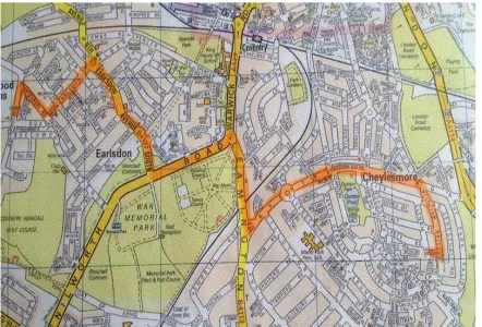
Figure 2: Highlighted route given to navigators to assist route learning
3.3 Design of Experiment
[image:11.595.76.518.357.657.2]Page 12 of 36 navigational aid which assisted the driver in navigating the route either a vehicle
navigation system (SatNav) or a passenger who provided directions along the route (Collaborative Navigation). The Dependent Variables were the navigation information which was issued to drivers by the navigators, performance and route learning
measures. The former consisted of the timing of the navigational cues and the
descriptors that were issued to drivers by navigators when describing route information. The latter consisted of the number of errors which were made when navigating the route and how well drivers in each condition were able to remember elements of the route. Any gestures which were made by the passenger to the driver were also noted from the videos, along with their context.
3.3 Procedure
Page 13 of 36 The road study commenced with a briefing session where the participants were provided with an information sheet which detailed what would happen during the study, what was expected of the participant and the potential risks associated with taking part. None of the participants were specifically informed that their route knowledge would be tested at any point. Upon giving their informed consent the participants were directed to the start of the predefined route.
In the SatNav condition the driver would navigate the route alone, only
following the prompts of the satellite navigation device. Prior to starting this condition drivers were trained in the use of the navigation system, although they were not
expected to interact with the system while driving (i.e. the destination was entered prior to the vehicle moving). In the collaborative condition the drivers and navigators were directed to the start of the route in the same way, where participants then assumed the roles of driver and navigator.
The route that participants followed incorporated a variety of different road and junction types (T-junctions, roundabouts, traffic lights) and took participants around ten minutes to complete in clear traffic. Throughout the task the cameras situated in the cab of the vehicle recorded the actions and utterances of the participants. In addition, an experimenter sat in the back of the vehicle passively observing participants’
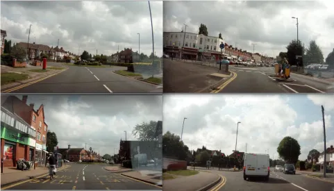
Page 14 of 36 Figure 3: A selection of route images shown to participants in the route-learning task
Immediately after the trial, drivers in both conditions were asked to complete two route-learning tests – commonly employed in the spatial cognition and wayfinding literature (Galea & Kimura, 1993, Head & Isom, 2010, Heft, 1979) In the first task landmark knowledge test, participants were given a set of 24 images (see Figure 3) and told that some of the images appeared on the route that they had just travelled and some had not (in fact 12 of these images had appeared on route and 12 images were of
Page 15 of 36 Following the road trial, participants were guided back to the company offices by the experimenter and were brought to a room for a debriefing session. Here
participants were interviewed separately in a semi-structured format on their
experiences. Participants were asked specifically to talk about elements of the task that they felt worked well, and those they felt didn’t, or caused difficulty.
4.0 Analysis Approach
4.1 Breakdown of the navigation task
The videos were analysed to provide transcripts of the spoken information issued by the passenger to the driver. By using a method developed by Burnett (1998), the navigation information was subsequently placed into one of five categories (preview, identify, confirm, confidence and orientation) according to the timing at which it was issued and the intended goal of the information. This method views navigation as a continuous task and suggests that support is required across a number of different stages, for example, information may be required or desirable before the driver begins the journey, on the lead up to the manoeuvre (preview), immediately prior to (identify), or directly
following the completion of the manoeuvre (confirm), or across the whole time frame of the navigation task to either reassure the driver that they are on the right path
(confidence), or to make the driver aware of their current location in relation to their general surroundings (orientation).
The mean scores of the navigation breakdown were then compared against the auditory prompts issued by the SatNav along the same route. Only the auditory
Page 16 of 36 guidance should be the primary modality with which a system interacts with the driver
(Kainulainen, Turunen, Hakulinen, & Melto, 2007, Reagan & Baldwin, 2006).
Additionally, this is the same modality used within the collaborative condition, allowing navigational prompts to be easily compared.
4.2 Breakdown of route descriptors
To analyse the different descriptors contained within the navigators route directions a further method developed by Burnett (1998) was used to analyse the content of route directions. This method, whose development is grounded in the previous work of Lynch, (1960) and Down & Stea (1977), defines a descriptor based on the type of information used to describe a portion of the route. For example, descriptors can utilise direction, distance, path (road), node (junction), landmark or road sign information to assist the driver along the route, with each of these categories containing sub elements related to the perspective from which directions are given. However, upon analysing the collaborative transcripts it became obvious that navigators occasionally utilised
dynamic environment information to assist the driver along the route. For example,
Ok so we’re going left at the crossroads. So following the black car
You kind of bear left (gestures). Do you see where that golf is going?
Page 17 of 36
4.3 Route Learning
Route learning data was analysed using a method developed by Webber (2013), which utilised other well-established approaches (Oliver & Burnett, 2008; Burnett & Lee, 2005; Golledge, Ruggles & Pellegrino 1993) as a basis for method development. This approach provided two scores: a percentage score for the landmark knowledge test and a total error score for the route knowledge task. To mark the landmark knowledge test, the total number of images which were correctly placed on route was used to calculate a percentage correct for each route. Therefore, participants could score a minimum of 0 and a maximum of 100% correct for each route.
The route knowledge test used absolute error as a base index of error. The position of each image was scored relative to its actual position on route. For example, an image placed 4 places away from its correct location on route would receive an error score of 4. Therefore, all images placed in their correct position would earn an absolute error of 0, whilst a maximum error of 72 could be achieved. To account for the
differences at average levels of performance (where using the absolute error score alone would not provide adequate sensitivity), a ‘sequencing value’ was also generated. This was the number of the longest string of images which were placed together without error. For example, if all images were placed in the correct order a sequencing value of 11 would be achieved. Final total error values were calculated by subtracting an
Page 18 of 36 5.0 Results
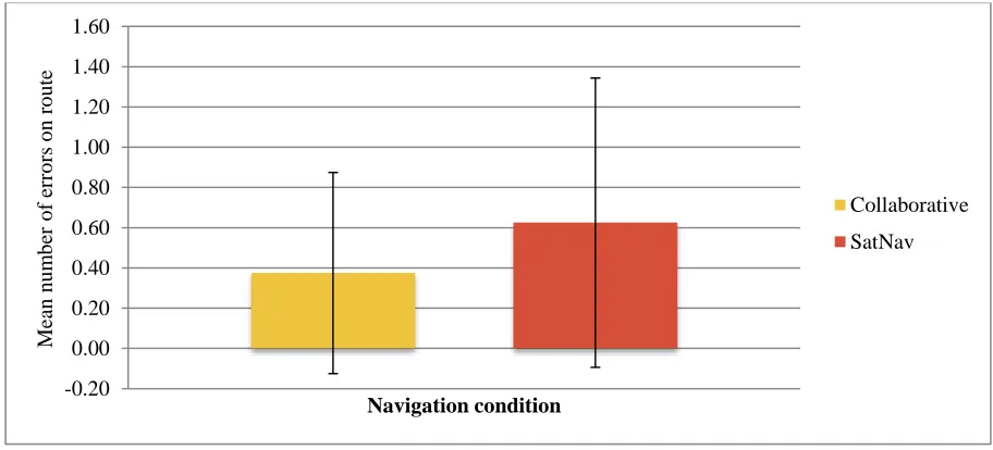
[image:18.595.83.539.252.459.2]5.1 Number of navigational errors made on route
Figure 4 shows the mean number of navigational errors made on route by drivers in the collaborative and SatNav conditions. This graph illustrates the small number of
navigational errors made by drivers in both conditions.
Figure 4: A comparison of the mean number navigational errors made by drivers in the collaborative and SatNav conditions
Whilst drivers in the SatNav condition made more navigational errors (M = 0.63) on average than their collaborative equivalents (M = 0.38) an independent samples t test revealed that this difference was not significant, illustrating that both methods assisted drivers in reaching their destination in an efficient manner.
5.2 Breakdown of the navigation task
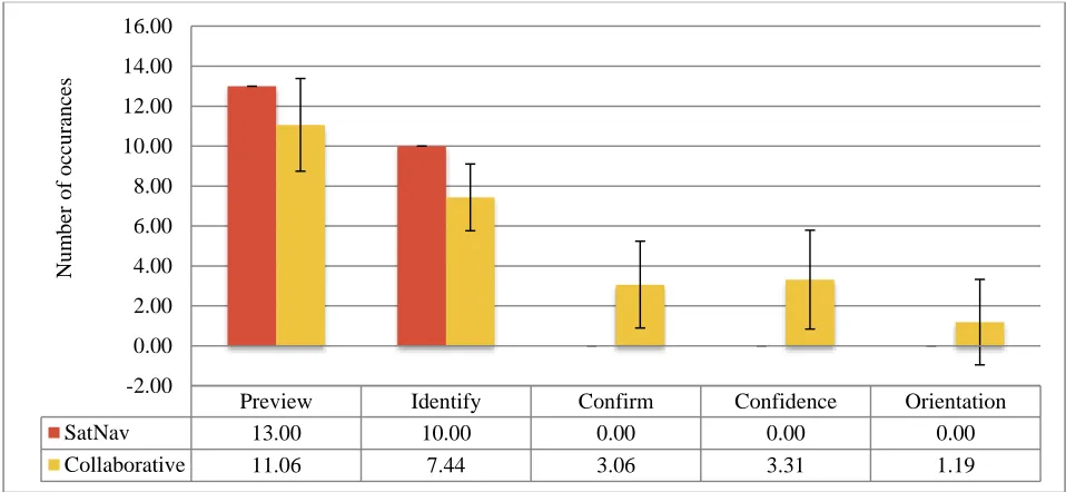
Figure 5 shows the number of information elements described by the SatNav and collaborative navigator across the route. This graph illustrates the similarities across
Page 19 of 36 both conditions in the issue of preview and identify information to the driver, whilst also highlighting the breath and variation of navigation information issued by the individual collaborative navigator.
Figure 5: A comparison of the timescales of information issue between collaborative navigators and a SatNav device
5.3 Breakdown of route descriptors
Figure 6 shows the number of information types issued by the SatNav and collaborative navigator along the route, highlighting the differences in the descriptors used in route information by each method and variation observed amongst individuals.
Preview Identify Confirm Confidence Orientation
SatNav 13.00 10.00 0.00 0.00 0.00
Collaborative 11.06 7.44 3.06 3.31 1.19
-2.00 0.00 2.00 4.00 6.00 8.00 10.00 12.00 14.00 16.00
Nu
m
b
er
o
f
o
cc
u
ran
ce
Page 20 of 36 Figure 6: A comparison of the number of information types spoken by navigators and a SatNav device
5.4 Route Learning
[image:20.595.85.576.66.350.2]5.4.1 Images correctly placed on route
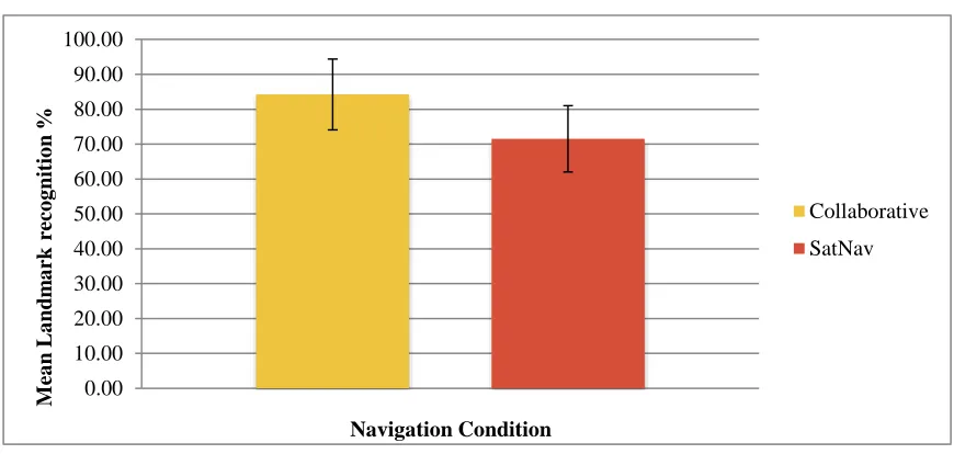
Figures 7 and 8 show the landmark knowledge of collaborative and SatNav drivers, highlighting the superior landmark knowledge of collaborative drivers.
Direction Distance Path
(Road)
Node
(Junction) Landmarks Road Signs
Dynamic Landmarks
SatNav 12.00 8.00 4.00 4.00 0.00 0.00 0.00
Collaborative 12.63 1.13 3.19 4.44 4.19 2.56 0.31
Page 21 of 36 .
Figure 7: A comparison of collaborative and SatNav drivers mean landmark knowledge along the route
Figure 7 shows the mean number of images that were correctly placed as having been on the route just travelled, expressed in percentage form, together with standard
deviation bars. An independent samples t test indicated that drivers in the collaborative condition (M = 84.25, SD = 10.16) placed significantly more route landmark images correctly on route than drivers in the SatNav condition (M = 71.5, SD = 9.51) T(30) =3.66, P<0.05 (two tailed).
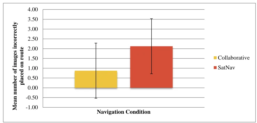
6.4.2 Images incorrectly placed on route
Page 22 of 36 Figure 8: A comparison of the number of images placed incorrectly on route by
collaborative and SatNav drivers
Figure 8 shows the mean number of images that were incorrectly placed as having been on the route just travelled, expressed in percentage form, together with standard
deviation bars. An independent samples t-test revealed that drivers in the collaborative condition made significantly less errors (M = 0.88, SD = 1.41), on average placing fewer images incorrectly on route than the SatNav drivers (M = 2.13, SD = 1.41), T(30) = 2.51, P<0.05 (two tailed).
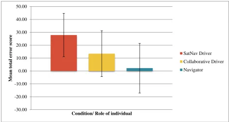
6.4.3 Route error scores
Page 23 of 36 Figure 9: A comparison of the mean route error scores of SatNav drivers, collaborative drivers and navigators
A one-way ANOVA was performed which indicated that the experimental condition and the role of the individual had a significant effect on the error score of the individual and hence associated route learning F(4,45) = 8.21; P<0.05. A series of independent T-tests were then performed to establish which pairs of means differed. From these a significant difference was revealed in the error score of SatNav drivers and
collaborative drivers T(30) = 2.36, P<0.05 (two tailed) with collaborative drivers having a significantly lower error score (M = 13.44, SD = 17.75) than SatNav drivers (M = 27.88, SD = 16.86), indicating that collaborative drivers had significantly better knowledge of the route than their SatNav counterparts. An unpaired t test revealed that navigators had significantly better route knowledge (M = 2.19, SD = 19.25) than SatNav drivers T(30) = 4.02, P<0.05 (two tailed). However, whilst there was an
observed difference in the mean error scores of collaborative drivers and navigators, the results of the t test revealed that this difference was not significant.
-30.00 -20.00 -10.00 0.00 10.00 20.00 30.00 40.00 50.00 M ea n to ta l er ro r sco re
Condition/ Role of individual
SatNav Driver
Collaborative Driver
Page 24 of 36 6.0 Discussion
6.1 Breakdown of navigation task
The results illustrate that the average navigator provided less preview and identify information than the SatNav voice, with the SatNav providing this information consistently for each turn and repeating these prompts when two turns were in close proximity to one another. Whilst the collaborative condition on average provided less preview and identify information, with some individuals not consistently providing this information for each turn, this lack of consistency and differences amongst individuals could be attributed to the shared context of the collaborative driver and navigator. Once navigators had issued navigation information to the driver, they could look to the driver to see whether this information had been heard and understood. Indeed, it was observed that some partnerships confirmed their understanding of one another’s instructions or questions with non-verbal exchanges, for example a nod of the head or a directional hand gesture. Therefore, if a navigator had believed that their route directions had been understood, they may have felt it unnecessary to provide the driver with an additional prompt.
Page 25 of 36 Another notable feature of the preview and identify prompts provided by
navigators was the consideration of the driver’s current context and likely workload. Here navigators were able to cut in where the driver was in conversation or when they appeared to not be attending to the upcoming manoeuvre and provide the navigation information or highlight an approaching manoeuvre, e.g,.
Driver: Yeah, at Warwick uni… some guy decided to sit in the middle of the junction.
Passenger: (cuts in) Wait one second. Please keep left… so all the way left. Here (points to turning)
However, passengers acting as navigators issued a greater breadth of
information throughout the navigation task, utilising confirm information an average of three times over the course of the route. Such confirm information presumably allowed drivers to check their understanding of the navigation instructions at important decision points throughout the route. Navigators were able to quickly respond to these requests for confirmation, which occasionally referenced an element of the environment in relation to the turn. Here navigators were able to provide reassurance that the correct route was being followed and that no navigational errors had been made, without any delay to the driving task, for instance:
Driver: Go straight on? (at mini roundabout)
Passenger: yep straight on, yep.
Driver: Straight on? (asks this at the end of the row of shops ).
Page 26 of 36 As the information flow from the Satnav is one way (from system to driver) no confirm information was issued verbally by the device. However, it can be argued that the visual interface which displays the current scene indirectly provides confirm information in visual form. Nevertheless, if a driver doesn’t understand the
representation of a junction on the device or the system is experiencing lag, there is no way in which the driver is able to check their understanding of this navigation
information.
Confidence information was also an important difference between the two methods of navigating; with the average collaborative journey containing three confidence prompts, in comparison to a SatNav journey which didn’t feature any auditory confidence prompts. Here, passengers could reassure drivers that the correct route was being taken during periods where no action was required. For example the use of phrases such as “keep going” and “you’re alright” were commonly used to provide reassurance to drivers that they were on the right path. However, it could be argued the image of the route presented by the SatNav also serves this same purpose in implicit visual form. This visual image allows drivers to verify their understanding of the issued route directions by checking the corresponding visual image represented on the
Page 27 of 36 the use of anthropomorphic feedback in system interfaces (Murano, 2006). Therefore, a voice interface for a future SatNav could utilise the same confirmation prompts as collaborative navigators fostering the development of a more sensitive, empathic system.
Orientation information was also occasionally used by navigators to provide drivers with an awareness of their location in relation to their general surroundings and final destination. Some navigators provided the driver with an overview of the route starting and end point prior to setting off, whereas others did this by informing the driver of the names of areas as they moved through them, with some navigators trying to situate an area in the driver’s previous experience. However, the employment of orientation information in route directions was subject to large individual differences, with a number of individuals providing no orientation information along the route and some making several references, e.g.
Passenger: …ok so now we’re going to Earlsdon. So keep going.
Driver: I don’t know where Earlsdon is.
Passenger: oh you don’t know? … oh there are some shops around here. Pretty sure you’ll have been here. Have you ever been to one of the curries before?
6.2 Breakdown of route descriptors
Page 28 of 36 with an absolute distance to turn value. These findings support previous work stating that humans have an inherent difficulty in mapping distance judgments onto the visual representation of routes (May, Ross & Bayer, 2003). The use of such descriptors in the collaborative condition saw some confusion amongst the partnerships where individual perceptions of distance weren’t matched.
Nevertheless, some similarities across the different methods were observed with the SatNav and collaborative navigators issuing similar numbers of distance, node (junction) and path (road) information. In particular, node and path descriptors were used to describe similar elements of the route in both conditions, with node information being primarily used to describe junction type and path descriptors being employed to describe the number of prior turns before the next decision point. Conversely, direction descriptors were employed in different ways according to the driving condition.
For direction information, there were some notable differences as the SatNav device essentially used direction descriptors to provide the driver with an ego-centred direction for the next turn, whereas collaborative navigators utilised direction
descriptors to provide the driver with ego-centred directions along the current road. Specifically, the collaborative navigators most commonly using these prompts in-between manoeuvres to provide reassurance to the driver that they were following the right path, e.g. to keep going straight on.
Page 29 of 36 the route, with these descriptors most commonly being used to in relation to decision points or manoeuvres. The use of descriptors at choice points and the subsequent improved route learning of collaborative drivers is consistent with the work of Allen (1997) who reasons that the use of landmark information at choice points allows
individuals to build a mental representation of a route. Using the environmental features contained in route directions, drivers were able to continually fix their current position with their mental representation and subsequently remember features of the route better than their SatNav counterparts.
However, what constituted a landmark varied widely across individuals. Most navigators selected environmental features that possessed a number of the attributes laid out by Burnett et al. (2001) including visibility, uniqueness and location in relation to a decision point. However, other individuals selected landmarks which were difficult for drivers to pinpoint in their environmental scene, placing greater visual demand on drivers who needed to slow down in order to scan the road – as shown by the following quote:
Passenger: Keep on for a little bit we’re gonna go past a disabled parking bay and turn right onto Ester or Esher road
Driver: So this one? (Driver gestures right)
Passenger: Narh Narh keep going… there’s the disabled bit (gestures ahead to it) So go on the next turning on the right… should be Esher road…. so this one.
Page 30 of 36 possibly hinting that detailed route descriptors which draw a upon a large amount of environmental information may have higher processing demands than more simple wayfinding information, e.g.
Passenger: Yeah so keep going down here. At the bottom of this road they’ll be a roundabout. There’s like a… I can’t remember what it is, it’s like a Coop on the
left and a pub on the right.
Driver: You’re confusing me now… I just need the high level.
6.3 Route Learning
The navigating condition was also shown to influence route learning, with collaborative drivers consistently performing better on route learning tasks than their SatNav
counterparts. These findings are consistent with previous work which has associated the use of current in-car navigation devices with driver disengagement from the
environment (e.g. Leshed, Velden, Rieger, Kot & Sengers, 2008).
The landmark knowledge test results demonstrated that in addition to
collaborative drivers being able to correctly identify significantly more junctions and landmarks which had appeared along their route, they were also significantly better at determining those junctions and landmarks which hadn’t appeared. These results suggest that the image selections made by collaborative drivers were the result of an enhanced route knowledge rather than random guesswork. According to previous work this enhanced landmark knowledge demonstrated by the collaborative drivers
constitutes the first stage in an individual’s cognitive map formation (Burnett & Lee, 2005; Gould, 1989).
Page 31 of 36 both conditions were given a number of images and asked to place them in the order in which they had appeared along the route. Drivers in the collaborative condition were able to place the images of the route in sequence with significantly fewer errors than those in the SatNav condition. These results indicate that the collaborative drivers had a significantly better memory of the route than those drivers who followed a SatNav device. Importantly, there was no significant difference in route error scores between collaborative drivers and navigators, indicating that navigators were able to pass on much of their learned route knowledge to drivers through their issue of route information. This enhanced route knowledge of collaborative drivers illustrates the further development of their cognitive map formation; these participants were able to more accurately link route landmarks, in order of appearance, displaying an enhanced knowledge for distances between landmarks and the actions required at each junction.
7.0 Conclusions and future work
The results of the study clearly demonstrate that navigating with the assistance of an informed passenger is strikingly different to navigating with the assistance of an
electronic navigation device, both in the array of descriptors used to communicate route directions and the fundamental nature of the interaction. Such differences have been shown to influence the route learning of the driver, with collaborative drivers
Page 32 of 36 The design of future navigation systems could use the collaborative model as a basis for system interaction. The current one way flow of information could be replaced with a two-way intelligent dialogue where drivers are able to continually check their understanding of route instructions issued by the system and mediate these instructions where they may have local knowledge - in essence, the creation of a navigation system that is able to operate with the same flexibility and awareness of context as a passenger. Additionally, this system could tailor navigation information based on driver familiarity with the route. Through utilising self-learning technology, the system could detect the frequency which routes are travelled, thus inferring the drivers’ familiarity with an area and falling into silent mode to allow the driver to navigate independently. Should the driver subsequently veer off route, systems could reactivate auditory prompts and resume navigation.
Page 33 of 36 action is required these landmarks may serve as markers along a route providing drivers with reassurance that the correct route is being followed.
Whilst these recommendations may appear to follow a number of themes, the concept which is at the core of future system development is the creation of a system which is able to interact with the driver in the way that an informed passenger does. As such, this system would utilise language in route directions which is more akin to human navigation, considering the driver’s previous journey knowledge - thus allowing them to seamlessly mediate route directions where they have previously experienced and the consideration of the different types of journeys drivers undertake.
8.0 References
Allen, G.L. (1997). From Knowledge to Words to Wayfinding: Issues in the Production and Comprehension of Route Directions. Spatial Information Theory: A
Theoretical Basis for GIS, Lecture Notes in Computer Science. 1329, 363-372.
Burnett, G.E. (1998). “Turn right at the Kings Head” Drivers requirements for route guidance information. Unpublished doctoral thesis, Loughborough University, England.
Burnett, G.E. (2000). ‘Turn right at the traffic lights’ The Requirement for Landmarks in Vehicle Navigation systems. The Journal of Navigation, 53(3), 499-510.
Burnett, G.E., & Lee, K. (2005). The effect of vehicle navigation systems on the formation of cognitive maps. In G. Underwood (Ed.) Traffic and Transport Psychology: Theory and Application. Elsevier.
Burnett, G., Smith, D., & May, A., (2001). Supporting the Navigation Task:
Page 34 of 36 Burnett, G.E. & Summerskill, S.J. & Porter, J.M. (2004). On-the-move destination entry
for vehicle navigation systems: Unsafe by any means? Behaviour and information technology, 23(4), 265-272.
Brown, B. & Laurier, E. (2012). The normal natural troubles of driving with GPS, In Proceedings of the SIGCHI Conference on Human Factors in Computing Systems. (pp.1621-1630). ACM
Dingus, T. A., Hulse, M. C., Antin, J. F., & Wierwille, W. W. (1989). Attentional
demand requirements of an automobile moving-map navigation system.
Transportation Research Part A: General, 23(4), 301-315.
Downs, R.M., & Stea, D. (1977). Maps in minds: Reflections on cognitive mapping. New York: Harper and Row.
Forbes, N. (2006). Online survey of in-vehicle navigation system users. University of Nottingham. http://www.mrl.nott.ac.uk/~nlf/
Galea, L.A.M., Kimura, D. (1993). Sex differences in route learning. Personality and Individual Differences. 14(1), 53-65.
Golledge, R.G., Ruggles., A.J., Pellegrino, J.W., & Gale, N.D. (1993). Integrating route
knowledge in an unfamiliar neighbourhood: Along and across route
experiments. Journal of Environmental Psychology, 13(4), 293-307.
Gould, M.D. (1989). Considering individual cognitive ability in the provision of usable
navigation assistance. In D.H.M. Reekie, E.R. Case & J. Tsai (Eds.),
Proceedings of Vehicle Navigation and Information Systems Conference (pp.
443-447). Piscataway, NJ: Institute of Electrical and Electronics Engineers.
Forlizzi, J., Barley, W. C., & Seder, T. (2010). Where should I turn? Moving from individual to collaborative navigation strategies to inform the interaction design of future navigation systems. In Proceedings of the SIGCHI Conference on Human Factors in Computing Systems (pp. 1261-1270). ACM.
Page 35 of 36 Heft, H. (1979). The role of environmental features in route learning: Two exploratory
studies of wayfinding. Environmental Psychology and Non-verbal behaviour, 3(3), 172-15.
Hegarty, M., Richardson, A.E., Montello, D.R., Lovelace, k., Subbiah, I. (2002) Development of a self-report measure of environmental spatial ability. Intelligence. 30. 425-447.
Kainulainen, A., Turunen, M., Hakulinen, J., & Melto, A. (2007). Soundmarks in
spoken route guidance. In Proceedings of the 13th International Conference of
Auditory Display (ICAD).
Leshed, G., Velden, T., Rieger, O., Kot, B., & Sengers, P. (2008). In-car GPS navigation: engagement with and disengagement from the environment. In Proceedings of the SIGCHI Conference on Human Factors in Computing Systems (pp. 1675-1684). ACM.
Lorimer, H. & Lund, K. (2003). Performing facts: finding a way over Scotland’s mountains. The soc. Review, 51 (s2)
Lynch, K. (1960). The image of the city. Cambridge, MA: MIT Press. Maurer, B., Trosterer, S., Gartner, M., Wuchse, M., Baumgartner, A.,
Meschtscherjakov, A., Wilfinger, D., Tscheligi, M. (2014). Shared Gaze in the car: Towards a Better Driver-Passenger Collaboration. Christian Doppler Laboratory for Contextual interfaces, ICTS&S Center, University of Salzburg, Salzburg, Austria.
May, A.J., Ross, T. (2006). Presence and Quality of Navigational Landmarks: Effects on Driver Performance and Implications for Design. Human Factors, 48(2), 346-361.
May, A.J. Ross, T., Bayer, S.H. (2003). Drivers’ Information Requirements when Navigating in an Urban Environment. The Journal of Navigation, 56, 89-100. Murano, P. (2006). "Why anthropomorphic user interface feedback can be effective and
preferred by users." Enterprise Information Systems VII. Springer Netherlands,
241-248.
Oliver, K.J., & Burnett, G.E. (2008). Learning-oriented vehicle navigation systems: A
Page 36 of 36
International Conference on Human Computer Interaction with Mobile Devices
and Services (pp.119-126), ACM Press.
Reagan, I., Baldwin, C.L. (2006). Facilitating route memory with auditory route guidance systems. Journal of Environmental psychology, 56, 146-155. Reeves, B. & Nass, C. (1996) The Media Equation How People Treat Computers,
Television, and New Media Like Real People and Places, Cambridge University Press.
Rowell, J.M. (2001). Applying map databases to advanced navigation and driver assistance systems. Journal of Navigation, 54, 355-363.