Lincoln University Digital Thesis
Copyright Statement
The digital copy of this thesis is protected by the Copyright Act 1994 (New Zealand).
This thesis may be consulted by you, provided you comply with the provisions of the Act
and the following conditions of use:
you will use the copy only for the purposes of research or private study
you will recognise the author's right to be identified as the author of the thesis and
due acknowledgement will be made to the author where appropriate
you will obtain the author's permission before publishing any material from the
thesis.
A thesis
submitted in partial fulfilment
of the requirements for the Degree of
Master of Landscape Architecture
at
Lincoln University
by
M. M. Flanagan
ABStrACt -
While we recognise that our current suburban form is unsustainable, and through regional growth management policy seek to intensify the city core and inner suburban areas, we do not have a new design programme for these liminal spaces. Intensification therefore falls to the suburban default, often resulting in compact suburbia, and undesirable urban environments. Using a ‘research through design process’ this thesis explores transit- oriented development as an alternative design programme for Addington, an inner suburban Christchurch space. Addington 2041 is a compact, mixed use, diverse urban landscape, clustered around a reactivated train network and station. Supported by educational, cultural, commercial, and residential activities, and a high quality pedestrian and public realm, Addington 2041 interprets an international urban form in the local context, and combined with a revealed sense of place and identity creates a liveable urban environment for the future.
KeY WorDS
-transit oriented development, Addington, liminality, new Urbanism, urban form.
Abstract of a thesis submitted in partial fulfilment of the
requirements for the Degree of M.L.A.
Addington 2041 - A Platform for Change
by
ADDINGTON 2041 - A PLAtforM for ChAnge ADDIngton 2041
iv
ACKnoWLeDgeMentS -
We had no idea that it couldn't be done
And we needed to find a like-minded someone
Who had no idea that it couldn't be done (extract from tim finn, ‘Couldn’t be done’)
I am extremely grateful to my supervisors who have guided this endeavour to completion. Particularly Jacky Bowring for her generosity of time, patience and valuable insights; and neil Challenger for always challenging my design decisions, and constant encouragement.
I would like to thank Mum and Dad for making me believe that I could achieve anything I set my mind to.
And most importantly, I would like to thank Dave, whose unwaivering support and patience have made this endeavour possible and bearable.
thank you all for being the ‘like-minded someone’s’ I needed.
tABLe of ContentS -
ABStrACt...iii
ACKnoWLeDgeMentS...iv
tABLe of ContentS...v
LISt of fIgUreS...vi
LISt of tABLeS...x
1.0 introduCtion...1
reSeArCh ConteXt...3
1.1 Local context 4
1.2 research aims 6
1.3 Method of enquiry 6
1.4 22nd february 2011 7
1.5 thesis framework 8
1.6 Personal context 11
theoretICAL ConteCt...12
1.7 A (very brief) history of modern cities 13
1.8 Urban utopia - the answer to the question? 17
1.9 Defining ‘transit oriented development’ 22
1.10 new urbanism meets Addington - a fruitful collision? 26
1.11 rise of the creative class 35
1.12 Summary 36
2.0 meThODOlOGy...37
2.1 research through design 33
2.2 Critique 37
2.3 Case study analysis 39
2.4 Summary 39
3.0 resulTs...47
4.0 CAse studies...101
4.1 new Lynn, Auckland 104
4.2 footscray, Melbourne 115
5.0 ConClusion...169
referenCes SIte In ConteXt...48
3.1 Site in context 49
MAJor DeSIgn...69
3.2 Master Plan 70
3.3 Intermediate Plan 72
3.4 Detail Plan 80
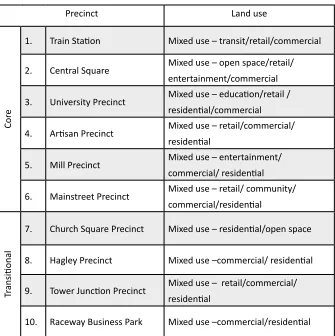
3.5 Addington 2041 Precincts 83
3.6 Planting Strategy 93
3.7 Planting Plan 96
3.8 Design Details 98
5.0 TrANsIT OrIeNTeD DevelOpmeNT...127
5.1 Context 129
5.2 form 132
5.3 Summary 150
6.0 liminAlity...151
6.1 Middle landscapes 153
6.2 Identity 160
ADDINGTON 2041 - A PLAtforM for ChAnge ADDIngton 2041
vi
LISt of fIgUreS -
figure 1-1 Addington, Christchurch figure 1-2 Method of enquiry
figure 1-3 Impact of the february earthquake on Addington figure 1-4 thesis framework
figure 1-5 theory manifesto figure 1-6 the industrial city
figure 1-7 Suburban mall typologies figure 1-8 Pattern of city evolution figure 1-9 1874 plan for Christchurch figure 1-10 Christchurch tram network figure 1-11 Urban typologies
figure 1-12 howard’s garden City figure 1-13 Le Corbusier’s radiant City figure 1-14 Wright’s Broadacre City figure 1-15 Suburbia
figure 1-16 Bigness
figure 1-17 Seaside, florida figure 1-18 City evolution
figure 1-19 Calthorpe’s transit oriented development figure 1-20 transit adjacent development
figure 1-21 transit oriented development
figure 1-22 transit oriented development corridor types figure 1-23 transit oriented development typologies figure 1-24 Compact suburbia
figure 1-25 Urban transect
figure 1-26 Addington’s urban fragments figure 1-27 Suburban fragments
figure 1-28 from the Agricultural to the Conceptual Age figure 1-29 Pink’s r-Directed thinking
figure 3-1 Site in context figure 3-2 Broad setting figure 3-3 Addington past figure 3-4 Addington present figure 3-5 Urban issues
figure 3-6 Urban opportunities figure 3-7 Addington
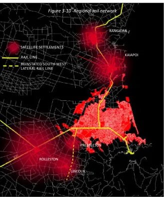
figure 3-8 UDS Settlement pattern figure 3-9 Inner suburban area figure 3-10 regional rail network
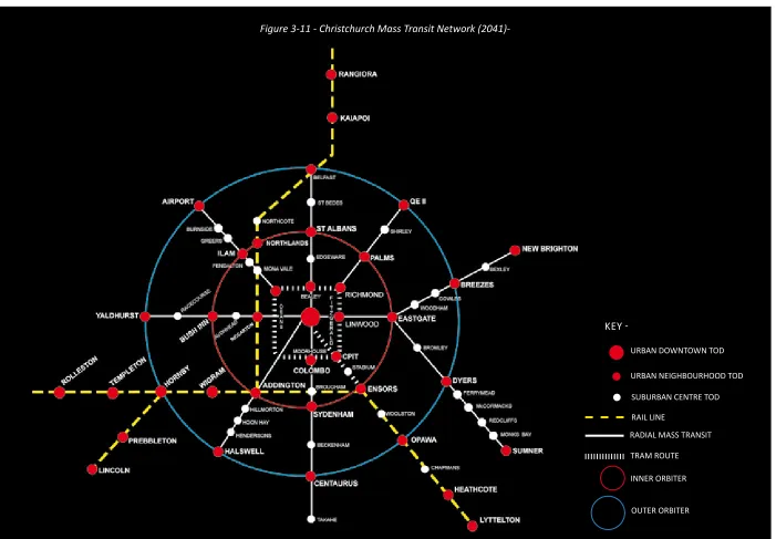
figure 3-11 Christchurch mass transit network (2041) figure 3-12 transit oriented typologies
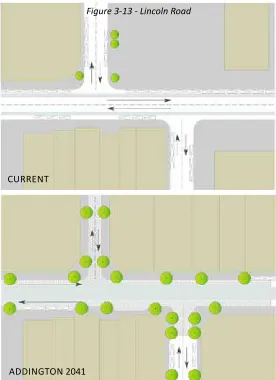
figure 3-13 Lincoln road
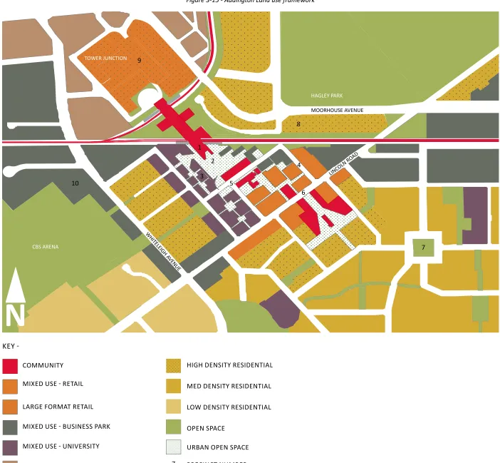
figure 3-14 Addington pedestrian network figure 3-15 Addington land use framework figure 3-16 Master Plan
figure 3-17 Intermediate Plan
figure 3-18 Indicative Cross section (north - South train Station) figure 3-19 Indicative Cross section (north - South Central Square) figure 3-20 Indicative Cross section (east - West Central Square) figure 3-21 Detail Plan
figure 3-22 Southern Cross Station, Melbourne figure 3-23 Central Square highline
figure 3-24 Central Square Seed Shed figure 3-25 University precinct figure 3-26 Addington 2041 figure 3-27 Artisan precinct figure 3-28 Walsall Street
figure 3-29 Bourke Street, Melbourne
figure 3-30 Addington main street (Lincoln road) figure 3-31 Medium density (Church Square area) figure 3-32 hagley Park
figure 3-33 tower Junction figure 3-34 hagley Precinct
figure 3-35 tower Junction Precinct 1.0 introduCtion
2.0 meThODOlOGy
3.0 resulTs
figure 3-36 Show Place business park figure 3-37 raceway business park figure 3-38 Planting Strategy figure 3-39 Planting Plan figure 3-40 Construction Detail
figure 5-1 Mono-centric and Poly-centric form figure 5-2 Case study development typologies figure 5-3 Adding density and land use pattern figure 5-4 new Lynn transit interchange figure 5-5 Auckland railway network
figure 5-6 Melbourne regional train network figure 5-7 Local footscray train network figure 5-8 Local footscray bus network
figure 5-9 elements of a pedestrian friendly landscape figure 5-10 transit oriented development land use mixes figure 5-11 Comparative land use mixes
figure 5-12 Universities as people generators figure 5-13 elements of a liveable place figure 5-14 node and place
figure 5-15 transit oriented continuum
LISt of fIgUreS -
figure 4-1 Waitakere City growth profile figure 4-2 new Lynn, Auckland
figure 4-3 new Lynn transit interchange figure 4-4 new Lynn precinct plan figure 4-5 Merchant Quarter today
figure 4-6 Artists impression of todd triangle figure 4-7 Crown Lynn concept
figure 4-8 Artist’s impression, high density housing figure 4-9 Artist’s impression, Western gateway figure 4-10 Artist’s impression, the Mall Promenade figure 4-11 Breakdown of Mall structure
figure 4-12 Artist’s impression, the Avenue figure 4-13 Industrial precinct
figure 4-14 Activity Centres, Melbourne figure 4-15 footscray precinct plan
figure 4-16 nicolson Mall and Maddern Square figure 4-17 footscray transit station
figure 4-18 railway precinct plan
figure 4-19 Mcnabb Street development figure 4-20 Joseph road precinct
4.0 CAse studies
5.0 TrANsIT OrIeNTeD DevelOpmeNT
figure 6-1 Middle landscape possibilities figure 6-2 Inside - outside
figure 6-3 Addington Coffee Co-op figure 6-4 outdoor performance spaces figure 6-5 third places
figure 6-6 Addington’s urban fragments figure 6-7 redepolyment of urban fragments figure 6-8 the ‘Mill’ Identity.
figure 6-9 Addington materials palette figure 6-10 the story of place
figure 6-11 the railway story
ADDINGTON 2041 - A PLAtforM for ChAnge ADDIngton 2041
viii
LISt of tABLeS -
table 1-1 transit oriented development versus traditional development table 1-2 Density cues
table 1-3 Attributes of the Creative Class
table 3-1 Projected household growth in greater Christchurch 2007- 2041 table 3-2 Christchurch Urban growth Policy Context
table 3-3 Urban intensification scenario for Addington table 3-4 Addington precinct framework
table 4-1 new Lynn precinct framework table 4-2 footscray precinct framework
1
INTRODUCTION
ADDINGTON 2041 - A PlAtform for ChAnge CHAPTER 1.0 - INTRODUCTION
4
Lewis Mumford once said,”forget the damned motor car and build the cities for lovers and friends” (from My Works and Days (1979)).
I wonder what a city for lovers and friends looks like? How and where do people live? Where do they work? How do they travel between the two? And, more importantly do they enjoy living in such a city? Mumford’s observation goes much deeper than simply abandoning the car. A city for lovers and friends suggests humanity, connection, resilience; it makes time for meeting, conversation, and fun; it celebrates diversity, inclusion and character; and perhaps most importantly, it makes us feel good.
The question then becomes, what is an urban form that makes us feel good?
Since urban settlement began, people have actively intervened in the nature and form of development to achieve social, political or environmental goals (United Nations Human Settlements Programme, 2009). In recent times, the modernist planning approach of monofunctional zoning has seen increased separation between home and work, and increased dependence on the private motor vehicle. This approach, a response to the congested, sickly, and immoral conditions of the industrial city, has spawned urban forms that “reinforce spatial and social exclusion, and produce cities which are not environmentally sustainable” (ibid, p. 59).
As well as being socially and environmentally unsustainable, our current urban form faces significant challenges. Climate change, oil depletion, over-exploitation of resources, globalisation of markets, and population growth will all have direct impacts on urban form (ibid). The drawbacks of modern urban planning, coupled with these growing environmental and social challenges, has seen the rise of alternative approaches to urban planning; the most dominant being New Urbanism. Such an approach, under the guise of ‘smart growth’, or ‘compact cities’; promotes compact form, mixed land uses, mass transit options, attractive public spaces, and pedestrian friendly streetscapes (ibid).
The move to more compact cities is not an easy one. Whilst proponents argue that a compact urban form is more “efficient, inclusive and sustainable”; critics counter that it is contrary to both market forces and our desire for suburban living; increases congestion and pollution; and drives up the cost of land and housing (United Nations Human Settlements Programme, 2009, p. 159). Changes to urban form will not come easily. It will require more than a physical change in form. A paradigm shift in the way we live, interact, govern and experience space will be required.
Inspired by a desire to find a ‘city for lovers and friends’, Addington 2041 – explores the future of Addington, and asks: what is its urban form?
1.1 LOCAL CONTEXT
-Despite our rural and wilderness identity, New Zealanders are “overwhelmingly ‘townies’” (Department of Internal Affairs, 2006, p.9). We live in one of the most urbanised nations in the world with approximately 87% of the population living in urban/suburban areas. Our cities generally started as trade centres, expanding outwards along rail, and then road corridors. After World War II, these cities grew rapidly, moving outwards across the landscape as dense road networks and low density, suburban sprawl (Memon & Perkins, 1993). This urban form, whilst catering to the New Zealand ‘quarter acre’ dream, has negative effects on the natural, physical and social environments. The consequences of urban sprawl are well documented, and hence will not be debated in this thesis. Suffice to say, the generally accepted consequences of sprawl include:
Increased dependence on the car resulting in increased traffic congestion, fossil fuel consumption, and air pollution.
Loss of productive rural land.
Loss or fragmentation of natural habitat and landscapes. Adverse effects on water quality and quantity.
Decay of public open space.
Suburban hubs out compete the city core contributing to a decline of the core.
Increased demand for infrastructure services (power, water, waste, telecommunications)
Poorly planned communities lacking an identity or community heart Loss of heritage and neighbourhood character.
Dispersed settlement with reduced connectivity between living and working environments.
Public health effects - obesity, traffic fatalities. Exclusion of those without access to a car. Loss of social capital.
(Brown et al, 2009, DeGraff et al, 2008; Greater Christchurch Urban Development Strategy Forum, 2007; Macionis & Parrillo, 2010).
Sprawl and its consequences are not something that happens elsewhere; it happens in our neighbourhoods, and this thesis is grounded in one of these neighbourhoods - Addington . Located in Christchurch, New Zealand, Addington is one of the city’s first suburbs. Once a thriving railway town and industrial hub, Addington is now tired and lost. Sprawl has drawn investment away, and it cannot compete with the glitz and convenience of suburban malls and business parks.
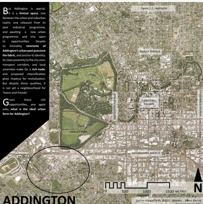
-ADDINGTON
Figure 1-1 - Addington
hAgley PArk
BEALEy AvENUE
MOORHOUSE AvENUE
FIT
ZG
ER
AL
D
A
vE
N
U
E
RO
LL
ES
TO
N
A
vE
N
U
E
CATHEDRAL SqUARE
B
ut Addington is special. It is a liminal space, one between the urban and suburban realm; one released from its past industrial programme, and awaiting a new urban programme; and one open to opportunities. Despite its liminality, remnants of Addington’s urban past puncture the fabric, and anchor its identity. Its close proximity to the city core, transport corridors, and local amenities make for a rich node; and proposed intensification gives impetus for revitalisation. But despite these qualities, it is not yet a neighbourhood for ‘lovers and friends’.g
iven these richopportunities, one again asks; what is the ideal urban form for Addington?
0
500
1000
1500
METRESN
Source: Google Earth, ©2011, Whereis , Sensis Pty Ltd, Accessed 27June 2011
ADDINGTON 2041 - A PlAtform for ChAnge CHAPTER 1.0 - INTRODUCTION
6
1.2 RESEARCH AIMS -
Deming and Swaffield suggest that “all research and design projects share the same beginning – an awareness, articulation and acceptance of a problem“ (2010, p.48). Under the broad context of ‘what is the future urban form for Addington?’ the ‘problem’, or opportunity, in this instance is a convergence of three lines of enquiry:
1. What is the future programme for liminal urban spaces? Spaces that are neither urban nor suburban; spaces which have been released from past programme, and not yet been inscribed with the future; spaces with unrealised potential.
2. What is the future local urban form given the current focus on sustainability, consolidation and intensification? And
3. Can international planning and design constructs be applied successfully in the local urban context?
Tying these questions together, and grounding them in the spatial context of Addington, this study seeks to explore ‘Addington’s conceptualisation as
a transit oriented development’.
Using Deming and Swaffield’s checklist for framing research questions, this thesis can be summarised as follows:
Topic – I am investigating the future urban form of Addington.
Question – Because I want to find out if transit oriented development is an appropriate design programme for local, urban liminal spaces.
Strategy – I am using a projective design strategy.
Motive – In order to understand the application of transit oriented development in the local context (2010, p.52).
Addington 2041 – A Platform for Change, therefore considers Addington’s
future as a transit oriented development.
1.3 METHOD OF ENQUIRY -
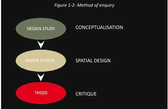
This thesis, undertaken through the landscape architecture discipline, is a design driven approach to research. Whilst accepted within the discipline as a legitimate method of critical enquiry; research through design still struggles for validity against the scientific trifecta of hypothesis, testing and proof. This thesis combines traditional research methodologies of observation, literature review, testing and case study analysis, with the [non] traditional approaches of design and critique; for the purpose of creating new knowledge on future urban form in the local context.
Breen suggests that “designing is essentially an activity of conceiving futures” (in De Jong & van Der voordt, 2002, p.97), and this thesis is the final instalment in a research through design trilogy that explores the future urban form of Addington (refer Figure 1-2). The first stage, a design study, considered ways of conceptualising the suburb of Addington. The second stage, comprising a major design exercise, grounded the theory in a spatial context through investigation of Addington as a transit oriented development. The final stage, this thesis, explores the transit oriented design for Addington in its local and regional context, and assesses its success relative to other transit oriented developments.
Given the infinite nature of design; its expression at a range of scales, and the interconnectedness of all elements, it was difficult to know where and when to cease designing. This research could have continued endlessly onwards and outwards; testing, refining, and resolving. However, given the finite nature of this thesis, it is essentially a sampling exercise looking at the expression of a transit oriented development at the neighbourhood, site, and element level.
CONCEPTUALISATION
SPATIAL DESIGN
CRITIqUE
Figure 1-2- Method of enquiry
-At 12.51pm on the 22nd February 2011, the urban form of Christchurch changed in a violent and devastating manner. Gaps in the urban fabric had already appeared after the September quake in 2010; however the 6.3 magnitude quake in February devastated not only the core of the City, but also parts of the eastern and hill suburbs, and over the Port Hills to Lyttelton. The scale of damage across the city suggests that “there is barely a house left in Christchurch that is not in need of repair work” (Cairns, 2011).
The effects of the quake are significant, and ongoing. Although secondary to the tragic loss of life, much of the City has been robbed of its heritage. Well loved buildings that define the Christchurch landscape are in pieces, including the iconic Christchurch Cathedral. There is the potential wholesale abandonment of some suburbs; and suburban facilities are coming under pressure from a temporary east-west migration. The City has lost its heart, literally and metaphorically.
But it’s not all bad news. Despite the human and material tragedy of the quake, there are positives that can be drawn from the event. In the hours and days following the quake communities rallied to rescue, assist, feed, and comfort their neighbours; in most cases people they had never met. It is this sense of community, this shared strength that will need to be carried to the recovery phase if we are to mend the urban fabric both physically and socially. Christchurch will face challenges going forward, and that journey is just beginning. The quake, and the subsequent rebuild, has bought urban form, architecture, heritage and landscape to the centre of public conversation. Let us hope that this conversation leads to a sustainable, resilient, exciting urban fabric, one that focuses on the future whilst still respecting the past.
When I started my thesis the urban form of Christchurch was directed by growth policies and market forces, rather than a natural disaster. My thesis seeks to explore transit oriented development as a new design
1.4 22
ndFEBRUARY 2011
-paradigm for delivering the consolidation goals of growth policy; and revitalising inner suburban areas. The design phase of my thesis, centred on Addington, was well underway at the time of the September 2010 earthquake, which fortunately had little effect on the site and its context within the city. The same cannot be said for the February earthquake which had a two-fold effect on Addington. The acute effect of the quake was the partial demolition of Woods Brothers’ Mill and silo; both iconic structures within Addington, and important elements of the design for Addington. A number of buildings along Lincoln Road, and Bernard Street also suffered significant damage (refer Figure 1-3).
The chronic effect of the quake has been the (re) occupation of Addington by displaced central city businesses relocating to the Hazeldean and Wrights Road business parks, and the establishment of a temporary business hub by Westpac at CBS Arena.
Although the February earthquake had a significant effect on Addington, and its context within the city, a decision was made to continue my thesis based on pre-earthquake conditions. As my thesis had reached an advanced stage with the design work complete and write up in progress, a redesign to address current conditions was not considered feasible. A post earthquake design investigation of Addington would constitute a completely new research exercise, particularly given the acute and chronic effects of the quake.
Therefore it is assumed for the purposes of my thesis that the flour silo, Mill Theatre, and other damaged main street buildings remain; and that Addington remains an urban intensification area supporting a semi-functioning city core.
Figure 1-3 - Impact of the February earthquake on Addington. Demolition of the flour silo -
Remaining mill building
-Main street Addington -
ADDINGTON 2041 - A PlAtform for ChAnge CHAPTER 1.0 - INTRODUCTION
8
Clemens Steenbergen in his ‘Composing Landscapes’ suggests that landscape architectonic design can be split to its constituent parts – basic form, spatial form, metaphorical form and programmatic form (2008). Through design these elements are disaggregated and reassembled as a new landscape composition. In my thesis the urban form of Addington is broken down into its constituents of place, space, symbol and programme; rearranged; and reassembled as a transit oriented design.
This thesis is organised around three elements of Steenbergen’s landscape composition – basic form, spatial form, metaphorical form. The fourth element, programmatic form; which concerns finding a balance between economics, culture and nature, has not been discarded but rather assimilated, where appropriate, into the other three constituent parts.
The framework of this thesis is as follows:
BASIC FORM – relating to place and context; SPATIAL FORM – relating to space and form; and METAPHORICAL FORM – relating to story and contents.
Steenbergen’s ‘basic form’ refers to the activation of the landscape topography through design; in his words “playing with place” (2008, p.39). He suggests that revealing the site’s topography through design is a way of revealing place (ibid). My use of basic form in this thesis differs from Steenbergen’s interpretation in that it focuses on context rather than topography. For urban sites, in this case Addington, I am suggesting that the basic form of the design is a product of its urban context, more than its topography. The latter of which is often long buried under layers of urban detritus.
Spatial form concerns the three dimensional arrangement of space to create a “spatial dynamic” (Steenbergen, 2008, p.127). For Addington this concerns the rearrangement (or reinstatement) of spatial elements to create a distinct form; firstly a transit oriented design, and secondly a creative hub. The activation of spatial form involves the integration of urban fragments into a unified whole; in this instance focussing on form, land use and transport.
Metaphorical form tells the story of place, making “references to origins and other worlds” (Steenbergen, 2008, p.236). Metaphorical form is the content that is woven through the basic and spatial form, connecting, as Steenbergen suggests, the past and the future (ibid). For Addington metaphorical form involves the exploration of liminality; and middle landscapes.
1.5 THESIS FRAMEWORK -
Whilst identifying design constituents, Steenbergen argues that design itself relates not only on the articulation of each of the constituents, but also their integration into a meaningful whole (2008). Similarly, while the design for Addington 2041 has been broken down into its constituent parts for ease of discussion; none of these parts exist in isolation. The basic form influences the spatial form, and vice versa; similarly the metaphorical form inspires the spatial form, and is reflected in the basic form. All the constituent parts interweave. The framework in Figure 1-4 provides a visual road-map of the thesis, including the chapter breakdown.
Each of the chapters, and in some instances sub-chapters, starts by asking a question. As the thesis progresses the questions narrow in scope, becoming more specific. The series of questions seeks to do two things; to define the focus of the chapter; and to take the reader on a logical journey from theory to design, and from regional to local (refer Figure 1-4).
-BASIC FORM
SPATIAL FORM
CONCLUSION
METAPHORICAL FORM
RESULTS
SITE IN CONTEXT INTERMEDIATE PLANMASTER PLAN
ADDINGTON PRECINCTS
DETAIL PLAN DESIGN DETAIL PLANTING STRATEGY
PLANTING PLAN
TRANSIT ORIENTED DEVELOPMENT
CASE STUDIES
RESEARCH THROUGH DESIGN
METHOD
INTRODUCTION
RESEARCH CONTEXTTHEORETICAL CONTEXT
MIDDLE LANDSCAPES IDENTITY
LIMINALITY
Figure 1-4 - Thesis Framework.What is the ideal urban form?
Ch. 1
CH. 2
Ch. 3
Ch. 4
CH. 5
What makes transit oriented development local?
How do you identify the ideal urban form?
What does transit oriented development look like in Addington?
Does transit oriented development work?
Is transit oriented development a design solution for our first suburbs?
CH. 6
ADDINGTON 2041 - A PlAtform for ChAnge CHAPTER 1.0 - INTRODUCTION
10
Figure 1-5 - Thesis theory manifesto
l
I
m
I
nA
l
I
ty
e
X
PAn
D
eD
f
I
el
D
neWUrBAnISm
tr
An
SIt o
rIenteDDe
SIgn
BroWnfIelDS
ter rA I n S v Ag
UeS D ro SS CAPe mAnU fA CtU re D SI te S lAn DSCA
Pe UrBAnISm,
CIty e
vo
lU
t
I
on
PlACeleSSS neSS
gl
oBAl
ISAt
Ion
Cr
I
t
I
CAl r
egIonAlISm
InvISIB
le Inf
rAS tr U Ct U re eC o lo
gICA
l met
hoD me SS y eC o S y S tem S toW n Pl An n I ng U to P I A mem ory SUStA In A BI l I t y Art geU r I llA gA r D en I ng me AnI n g
PAlImPSeSt InDUStrI Al rUI
nS
mIDD
le lAnDS
CA PeS
THEORy MANIFESTO -
In the process of conceptualising and designing Addington as a transit oriented development there are many other secondary layers of landscape theory that weave through the process. In some instances the theories, and their authors are not directly quoted, although they have shaped the thinking that has taken place. The theory manifesto in Figure 1-5 maps out the theoretical background that has inspired this thesis. Produced originally as part of the design study for Addington, this manifesto has been updated to highlight the theory streams considered most relevant to the major design and thesis stages of this study, and includes additional theoretical influences explored during these stages.
-Attoe suggests that “criticism is first and foremost about the critic, not about the object being criticised” (1978, p.8). The same could be said for design, which by its very nature is subjective; a product of the designer’s experience, knowledge and perspective. As this thesis is a mix of design and critique, the self-image of the designer/critic, and the framework within which these pursuits are undertaken, will influence the outcome. It is therefore useful to situate this thesis within the context of its author (myself) and its setting.
I must admit that I am new to the field of design and landscape architecture. I am however familiar with the manipulation of urban form, albeit from a different perspective. Prior to returning to postgraduate study I spent the better part of the last decade working as a planner in both the public and private sectors, focussing primarily on infrastructure projects (e.g. roading, telecommunications, wastewater and electricity). My move into landscape architecture was born of a desire to see if there was a better way of organising urban form. Planning, architecture, engineering, and landscape architecture, have all prodded at urban form over the years, with some success. However, cities are still sprawling on the periphery, and dying in the centre. I wondered whether a more integrated design based approach would work better, combining the analytical, evaluative and strategic skills of a planner with the creative, revelatory, and design skills of a landscape architect.
This thesis was undertaken as part of a professional Masters of Landscape Architecture at Lincoln University, Christchurch. In 2010 the final year programme of this degree was altered to offer a research by design thesis. Previous students followed a design study, major design, and dissertation route to complete the programme. I am the first student undertaking the design thesis, and as such there were no exemplars to follow,
1.6 PERSONAL CONTEXT-
no prescribed process, and only a loose definition of the expected outcomes. Being the ‘guinea pig’ in any setting is both exciting and challenging. To combat the lack of definition I took the attitude of just jumping in and hoping the line of enquiry would lead onto further connections or avenues; and in most instances it did. However, had I understood where the journey was headed I may have taken different roads, but as always that is the benefit of hindsight.
In undertaking research through design, I felt that my design work was required to have greater depth, than the final year undergraduate students in my studio tutorial group. This was both liberating and smothering. On the positive side, having a strong theoretical platform (transit oriented development) from which to draw virtually eliminated the dreaded ‘blank page’ syndrome, where one stares at a page wondering where to start; and encouraged me to push the design envelope. On the negative side this platform provided a seemingly endless string of ideas and elements to explore, which had the potential to lead to infinitely detailed studies, and required self discipline to keep in check. It was a challenge, but nonetheless an exciting one!
Little boxes on the hillside, Little boxes made of ticky-tacky, Little boxes, little boxes, Little boxes, all the same.
There's a green one and a pink one And a blue one and a yellow one And they're all made out of ticky-tacky And they all look just the same.
And the people in the houses All go to the university, And they all get put in boxes, Little boxes, all the same.
And there's doctors and there's lawyers And business executives,
And they're all made out of ticky-tacky And they all look just the same. And they all play on the golf-course, And drink their Martini dry,
And they all have pretty children, And the children go to school. And the children go to summer camp And then to the university,
And they all get put in boxes And they all come out the same.
And the boys go into business, And marry, and raise a family, And they all get put in boxes, Little boxes, all the same.
There's a green one and a pink one And a blue one and a yellow one And they're all made out of ticky-tacky And they all look just the same.
Malvina Reynolds (1962)
ADDINGTON 2041 - A PlAtform for ChAnge CHAPTER 1.0 - INTRODUCTION
12
THEORETICAL CONTEXT
1.7 A (very brief) HISTORY OF MODERN CITIES -
Source :, “Five Cents a Spot”, in ‘How the Other Half Lives: Studies Among the Tenements of New york’ (New york: Charles Scribner’s Sons, 1890; reprint, New york: Dover, 1971). Courtesy of the Museum of the City of New york, Jacob A. Riis Collection. (Accessed May 18, 2011). Source: “Italian Mother and Baby” [Photograph],” in Children and youth in History, Item #334, http://chnm.gmu.edu/ cyh/primary-sources/334
(Accessed May 18, 2011).
Source:”Bandits Roost” accessed at http:// en.wikipedia.org/wiki/File:Bandit%27s_ Roost_by_Jacob_Riis.jpeg
(Accessed May 18, 2011).
Figure 1-6 - The Industrial City -
Among the Tenements of New
york’ (1890), an early photojournal, recorded the squalid living conditions in industrial New york during the 1880’s. Jacob Riis, the photographer and author, used this essay to expose the conditions of the slums to upper and middle class society.
T
he city may be looked on as a story, a pattern of relations between human groups, a production and distribution space,a field of physical force, a set of linked decisions, or an arena of
conflict. (Lynch, 1981, p.38). Before exploring Addington as a transit oriented development, it is
important to understand the general values that shaped its context within the wider urban fabric, and gave rise to its current form. Whilst a detailed treatise on the origins of the city is outside the scope of my thesis, it is useful to explore the theories that have influenced modern urban form. Cities are a complex paradigm to understand, let alone design and plan. Common analogies help; likening the city to a cosmos, a machine, and an organism for example (Lynch, 1981). Whilst considering the city in machinic or organic terms may help clarify its functions and parts, it sheds little light on its genesis, and therefore in turn, its future.
Early (pre-industrial) cities were shaped by forces such as trade, agriculture or defense (Brown et al, 2009); with their location relative to advantageous landscape features (e.g. a harbour). The extent and layout of these cities was determined by how far a person could walk, resulting in compact, mixed use settlements (ibid).
The industrial revolution, in the 18th century, was a major turning point for urban form and settlement. New transit technology; railroad, and later street cars, subways and road networks, enabled industry and then cities to push outwards. New building technologies enabled the city to push upwards with multiple storeys (Macionis & Parrillo, 2010). As the economic base shifted from agriculture to industry, urban migration began with workers flocking to the factories, clustering in settlements around the factories, or along the transport corridors. Cities were no longer constrained by walkabilty and increased in both size and scale.
ADDINGTON 2041 - A PlAtform for ChAnge CHAPTER 1.0 - INTRODUCTION
14
These early suburbs created a new urban landscape of detached dwellings within a garden setting; an antithesis to the industrial city; a new urban dream. At first the domain of the rich, the expansion of train, tram and street car networks, combined with mass produced housing, saw urban development cluster around transit stations (Brown et al, 2009). These first suburbs essentially made early suburban living available to the wider middle and working class. While largely relying on the city for employment and amenities; local services addressed the everyday retail, community, and worship needs of residents. Continued urban growth saw these suburban clusters diffuse along the transit lines, eventually forming linear development corridors, radiating outwards from the city (ibid).
Continuing the trend of suburban development outside the city core, the private motor car was the next major influence on urban form. Previously the “plaything of the idle wealthy”; increased availability, and expanding road networks saw the motor vehicle become widely accessible, transforming it from an “upper-crust toy to a middle-class necessity” (Brown et al, 2009, p. 52-53). Combined with growing prosperity, growing populations, and the lure of green open space; the post World War II urban form of low density, single use, often mono-cultural development spread across the (rural) landscape (Macionis & Parrillo, 2010). The suburban lifestyle was one of personal freedom, mobility and convenience, all within a semi-urban, semi-rural (suburban) landscape. As the distance between home, work and shopping increased, so too did dependence on the car, and people quickly made the shift from public to private transportation.
As people migrated out to the suburbs, so too did retail businesses, creating a new suburban form – initially the shopping mall, and later ‘big box retail’. These large footprint, enclosed structures, surrounded by surface parking created a pseudo city, one that could “capture the car and store it so that people could walk, shop and civically engage in a fully pedstrian
environment” albeit separated from the surrounding landscape (refer Figure 1-7) (Brown et al, 2009, p.64). A close relative of the shopping mall, which also appeared, was the strip mall; a linear, retail development generally catering to commuters on busy arterial routes. With the migration of people, and retail businesses from the city core to the suburbs; commercial, manufacturing and industrial activities soon followed forming business and industrial parks on the city periphery.
As the upper and middle class citizens migrated outwards, the void in city cores was filled by ethnic minorities and low income earners who could not afford the suburban lifestyle. As people, industry and jobs decentralized, the city revenue base declined, resulting in an urban underclass experiencing poor living conditions, limited employment opportunities, and low amenity urban environments (Macionis & Parrillo, 2010).
Although in decline, the urban ‘bones’ of the city remained. As the delight of suburban living waned, due to increasing congestion, and the perceived blandness and isolation of the suburbs, the city’s transport networks, mixed communities, and urban grittiness once again became attractive. Enticed by these urban amenities, high-tech, postindustrial businesses moved back into the city (Macionis & Parrillo, 2010). The employees of these businesses, wanting to be closer to work, and enjoy the city, moved into decaying neighbourhoods, transforming them into desirable places to live (ibid). Although positive for the core, this rejuvenation often resulted in gentrification – or “a rise in social and economic profile” (Brugemann, 2005, p.4), resulting in an influx of wealthy residents and a displacement of the neighbourhood’s traditional residents. This gentrification generally results in socially and culturally homogenous neighbourhoods, with an altered (generic) character and form.
Figure 1-7 - Suburban Mall typologies
Strip mall - Hillmorton Westfield Mall - Riccarton
Big box retail - Tower Junction Lynn Mall - Auckland
-This (very brief) walk through the evolution of the city shows that since their inception, modern cities have essentially followed a centralization/ decentralization pattern; in response to changing social values (refer Figure 1.8). Christchurch in this instance is no different. The city began as a planned settlement, laid out in accordance with the 1850 Canterbury Association Plan (refer Figure 1-9) (Cookson & Dunstall, 2000). Although extending out to the four town belts (now the four avenues) the commercial and industrial heart of the city was enclosed by Salisbury Street, Barbadoes Street, St Asaph Street, and Antigua Street (Morrison, 1948). Christchurch differed from typical city evolution at this point as it did not experience the first wave of decentralization. The city gentry did not migrate outwards to escape the city but largely remained along the north-west of the grid (in the suburbs of St Albans, Fendalton and Riccarton). Those that did move went to the hill suburb of Cashmere or the seaside at Sumner (Cookson & Dunstall, 2000).
Figure 1-9 - 1874 Plan for Christchurch.
Migration to the industrial city from the rural surrounds.
Those that can afford to move out of the city creating early suburbss
Linear development along radial transport routes.
Infill development between suburbs.
Source - http://christchurchcitylibraries.com/Heritage/Maps/227628.asp (Accessed 3 June 2011).
Figure 1-8 - Pattern of city evolution.
ADDINGTON 2041 - A PlAtform for ChAnge CHAPTER 1.0 - INTRODUCTION
16
Settlement outside the town belts (Christchurch’s first cycle of decentralization) followed key transport routes radiating from the central city grid. Processing and manufacturing industries; and residential development, clustered along these routes. The catalyst for this expansion was the construction of public rail and tram networks. To the north of the city core, the tram network opened up the suburbs of St Albans and Papanui; to the east the suburbs of Linwood, Aranui and New Brighton; and to the west the suburbs of Riccarton Bush, Spreydon and Sockburn. To the south east the tram ran to Sumner and Opawa; and to the suburb of Cashmere in the south (refer Figure 1-10) (Cookson & Dunstall, 2000).
The dominance of the tram in Christchurch began to wane during the 1930’s, and by the 1950’s the bus had fully displaced it (Cookson & Dunstall, 2000). The loss of the tram network, and the growing availability of the motor car, saw settlements along and between the tram routes in-filled with auto-centric suburbs (the second cycle of decentralisation). Growing populations, increased individual mobility, and access to cheap land saw the city’s peripheral greenfields opened up for development. Unconstrained by topography Christchurch grew outwards in a series of concentric rings across fertile rural land (e.g. Marshland, Avondale, Bishopdale, Hoon Hay) (Cookson & Dunstall, 2000).
As the city expanded at the edges, suburban shopping centres developed, often at public transit termini or key road intersections. These centres reduced reliance on the city core, servicing the wider neighbourhoods’ everyday needs. Christchurch’s first ‘modern’ shopping malls at Bishopdale and Church Corner opened in the 1960’s, setting the scene for the current ‘mega’ shopping and entertainment centres at Riccarton, Papanui, Shirley, Linwood and Hornby (Wilson, 2005). These suburban developments contributed to a gradual decline of the city core with businesses “choosing to decentralise or relocate to suburban locations for various reasons including better quality space, more abundant and ‘at the door’ parking, and lower lease costs” (Christchurch City Council, 2001, p.9).
The Christchurch City Council recognised that the continual suburban expansion of the city would have significant effects on the city core, and be unsustainable in the long-term. The Greater Christchurch Urban Growth Strategy, which seeks to manage growth over the next thirty years, aims to arrest decentralisation through revitalising the central city, intensifying inner suburban areas, and limiting peripheral urban development. The question thus becomes what is the next phase in the decentralisation/centralization pattern, and what is the urban form that expresses this?
Figure 1-10 - Christchurch tram network
THEORETICAL CONTEXT
The quest for the ideal urban form is nothing new, and is an ongoing conversation (or argument) between the expanded field of disciplines that affect and are affected by urban form. The recent earthquake in Christchurch has propelled urban form to the forefront of public discussion, asking both professionals and the public “how the Central City should be redeveloped to be a great place again”1.
In this thesis, transit oriented development is being explored as the ideal urban form for the suburb of Addington. It is useful to understand the genesis of this form, through a review of modern urban utopian thinking. It is acknowledged that are many, and varied, utopian theories, and it is not the goal of this thesis to visit them all. Those included here are considered to be dominant movements in the urban form and planning genre, and are grouped into decentrist, post urban, and new urban streams (refer Figure 1-11).
1.8 URBAN UTOPIA - THE ANSWER TO THE QUESTION?
DECENTRISTS -
It was the poor urban form and social malaise of the industrial cities that first sparked the search for the modern ideal (utopian) city. Three leaders of modern urban planning; Ebenezer Howard, Le Corbusier and Frank Lloyd Wright, all sought to design the ideal city of the twentieth century. Such a city would express “the power and beauty of modern technology and the most enlightened ideas of social justice” (Fishman, 2003, p.21). All three rejected the romanticism of the ‘old world’ cities, and viewed cities of their time as an uncontrolled malignant growth sprawling into the countryside, centres overwhelmed with congestion and pollution, and growth driven by profit (Fishman, 1982). Their vision was a radical reconsideration of cities, rather than the amelioration of existing form. Each perceived the physical reconstruction of the city as “the outward sign of an inner transformation of the social structure” (Fishman, 2003, p.23), and each embraced the technology of their time – the train, the skyscraper, and the car.
Whilst Howard’s ‘Garden City’ is a blueprint for moderate decentralisation, it is by no means a rejection of urbanism, but rather a rejection of the “concentration of power and wealth that the cities represented” (Fishman, 2003, p.39). Howard envisaged a future where the benefits of the country were married to those of the city, creating a community “which would have high wages and low rents, beauty of nature but plenty to do”; “bright homes and gardens”,”along with freedom and cooperation” (ibid, p.39).
Figure 1-11 - Urban Typologies
NEW UBRANISM
CENTRIST Smart Growth
Compact Cities Transit oriented Development
Sprawling decentralisation U R B A N F O R M POST URBANISM Bigness Edge Cities Scape© Suburbia Traditional Neighbourhood Development Fractal city Continuous field Unmoderated city URBANISM DECENTRIST Garden City Radiant City Broadacre City Moderate decentralisation Great metropolis Radical decentralisation
ADDINGTON 2041 - A PlAtform for ChAnge CHAPTER 1.0 - INTRODUCTION
18
In contrast to Howard, Le Corbusier envisaged a much more radical urban form, a great metropolis of dense skyscrapers and highways. Le Corbusier saw the city as a place of interchange, a set of destinations through which man continuously moved. His ideal urban form was a simultaneous expression of individualism and cooperation that reflected his rejection of capitalism and embrace of syndicalism (a social order based on the organization of workers into production units) (Fishman, 2003). Le Corbusier envisaged a collective and ordered city, where the strict hierarchy of the business world was contrasted with a cooperative home life (ibid).
Corbusier’s ‘Radiant City’ consisted of a series of high rise apartment blocks, or Unités, at its centre. Each Unité is a vertical neighbourhood consisting of residential accommodation, leisure facilities, workshops, retail and services; all connected by vertical streets or elevators. Business centers were to be located in towers separate from the Unités. The Unité operated as a cooperative neighbourhood whereby residents could have their homes cleaned, meals made and children raised by others, leaving more time for leisure, and artisan skills. The vertical urban form of the city freed the ground plane for transportation and open space networks. Transport networks were independent of urban form, and modes were separated hierarchically and vertically. The street environment is rendered obsolete.
Figure 1-13 - Le Corbusier’s Radiant City.
Howard’s Garden City consisted of a series of compact urban centres (each housing a community of about 30,000), surrounded by a greenbelt of productive rural land and open space. These urban centres were intended to be self-sufficient, although they remained connected to the Central City via rail, and each other by inter-municipal links (refer Figure 1-12). Each urban centre was to be laid out in concentric rings around a central park and civic core. Moving outwards this core was to be surrounded by an enclosed retail precinct (‘Crystal Palace’); followed by homes and gardens radiating outwards to an industrial/manufacturing precinct on the periphery. Beyond this were allotments and farms that supplied the Garden City with food (Fishman, 1982).
Figure 1-12 - Howard’s Garden City.
Source: http://commons.wikimedia.org/wiki/File:Garden_City_diagram.
jpg#filelinks (Accessed 2 June 2011) Source: http://www.nyu.edu/classes/reichert/sem/city/lecorbu_img.html (Accessed 2 June 2011)
THEORETICAL CONTEXT
-Source: http://commons.wikimedia.org/wiki/File:Lorategi-hiriaren_ diagrama_1902.jpg (Accesssed 2 June 2011)
IMAGE REMOvED FOR COPyRIGHT
IMAGE REMOvED FOR COPyRIGHT
Wright, like Howard, saw decentralisation of the city as the urban ideal; although Wright’s proposition was much more decentralised, imagining in ‘Broadacres’ the very anti-thesis of the city (refer Figure 1-14). Wright embraced the car, envisaging a series of low density scattered homesteads, connected by superhighways (Fishman, 1982). Wright favoured a type of agrarian individualism where every family was entitled to sufficient land to satisfy their needs. This created a city whose inhabitants had almost complete physical, social and economic independence (ibid). Wright however did not see Broadacres as a reversion to a subsistence economy, but rather a return to the economic role of the family; activities that were once surrendered to urban institutions were now reconnected to the home (Fishman, 1982). This contrasts with the Corbusian vision of separating work and family life.
Broadacres could be viewed as a precursor to suburbia; with no defined city core, a blurred rural/urban interface, and the highway system acting as the linking or connecting element. Similar to suburban development, factories, schools and commercial centers would be scattered amongst the homesteads.
Figure 1-14 - Wright’s Broadacre.
POST URBANISM -
A second stream of decentrist thought considers the expansion of cities outwards, and the loss of the city core as an entirely expected phenomenon given changing societal values. Bruegmann suggests that “sprawl has been a feature of urban life since time immemorial”, and is merely a reflection of a cities growing economic maturity and affluence (2005, p.220).
As industrial city’s prospered, it allowed people choice. Initially only those with means could escape the pollution and congestion of the city. However as transport and housing systems changed, and land became cheap, moving out to the suburbs became an option for middle and lower class citizens. As Dicarlo suggests, “the suburbs have made it possible for ordinary Americans to enjoy the privacy, space, leisure time and choice that were once available only to the richest of the rich” (2008, p.54). And, whilst it could be argued that the desirability of today’s suburban living is a carry-over from the industrial city exodus, Dicarlo proposes that a return to compact, distinctly urban cities will do more environmental and social harm, suggesting that “trapping more people into a tighter space can only make pollution and traffic congestion worse” (2008, p.52).
Gordon and Richardson (1997) and Bruegmann (2005) also weigh in on this argument, suggesting that the costs of sprawl are not as dire as is often made out. For example both suggest that the movement of industry to the suburbs, following the workforce actually reduces road congestion and pollution; that despite the perceived loss of peripheral rural land agricultural yields are still rising; and that suburbs are not inherently unsustainable.
There is also the argument that the suburbs are actually a good place to live (refer Figure 1-15). O’Neill suggests that suburban living offers “enough space in the backyard for the children to frolic, just enough privacy to allow them to keep to themselves if that is what they want, but sufficient density to foster friendships and associations” (2008, p.56). Dicarlo goes onto suggest that the suburbs are not the “weird or depraved place” depicted in popular media through shows such as ‘American Beauty’ and ‘Desperate Housewives’ (2008, p.49), but are a place for ordinary people.
Bruegmann offers a different view on the suburban/urban conflict by suggesting that both spaces are valid within the city form. He proposes that suburbanites are not anti-urban. They do not reject the city, but rather value the two spaces for different uses. The suburbs are a “good place to live, work and raise children” whilst downtown is a good place to “go to a nightclub, visit a museum, or do some special Christmas shopping” (2005, p.97)
Source: http://en.wikipedia.org/wiki/File:Wright_Sketches_for_Broadacre_City.jpg (Image post: Kjell Olsen), (Accessed 2 June 2011).
ADDINGTON 2041 - A PlAtform for ChAnge CHAPTER 1.0 - INTRODUCTION
20
If the decentrist notion of sprawl is taken to extreme, what becomes of the ideal city? Rem Koolhaas puts the theory of ‘Bigness’ forward as a contemporary reading of cities (refer Figure 1-16). Koolhaas suggests that the traditional city typology is defunct and that sprawl, increasingly complex infrastructure networks, and global corporations have created a new urban form. This form, un-moderated, placeless, and without context, replaces the traditional organisation of cities.
Similar to Bigness, Koolhaas also introduced ‘Scape©’ as a way of thinking about contemporary urban form. Scape© suggests the city is an edgeless, continuous field with no distinction between core and periphery, figure and ground, inside and outside (Angelil and Kilingmann, 1999). In Scape© the urban field is interconnected; landscape, architecture and infrastructure all converge into an expanded field. If sprawl was to continue across Christchurch, unchecked and at an amplified rate, the urban form could be considered in the context of Bigness and Scape©. these theorums are not suggesting that this situation is necessarily ‘bad’ but simply an urban condition requiring a new way of planning and decision making. Under Bigness or Scape©, Addington would cease to be a definable suburb, it would simply be a patch in the urban field. As urban form moved across the landscape, place would be smothered or hidden, Addington as a spatial, social, cultural and historical entity would not exist.
Garreau offers a parallel argument to Koolhaas suggesting that the traditional city centre has passed, and that the emerging urban form is a series of ‘Edge Cities’. Such cities comprise large retail and commercial complexes on the periphery of settlement, generally with more jobs than housing (Gosling, 2003). Edge Cities essentially reverse the traditional commute; instead of travelling inwards from home to core, travel is outwards from home to edge (ibid). Garreau describes Edge Cities as urban spaces different from the core and the suburbs. He suggests that rather than footpaths there are jogging trails, low rise offices set in park-like landscapes, and freeways and satellite dishes rather than subways (Gosling, 2003).
Figure 1-16 - Bigness
Figure 1-15- Suburbia
THEORETICAL CONTEXT
-Exodus, or the voluntary Prisoners of Architecture, The Strip, Project, Aerial Perspective (Rem Koolhaas, Elia Zenghelis, Madelon vriesendorp and Zoe
Zenghelis).
Source: The Museum of Modern Art at http://www.moma.org/collection/browse_ results.php?criteria=O%3AAD%3AE%3A7558&page_number=3&template_
NEW URBANISM -
Decentrist and post-urbanist theory suggests fractal or flowing urban forms as city future, New Urbanism in contrast takes a centrist view, looking to the human-scaled and walkable city as the urban utopia. Gaining prominence as a planning and design theory in the United States in the early 1990’s, New Urbanism, advocates a return to traditional neighbourhood design as an antidote to suburban sprawl. New Urbanism contests that planning for sprawl has resulted in “the creeping deterioration of once proud neighbourhoods, the increasing alienation of large segments of society, and constantly rising crime rates and widespread environmental degradation” (Katz, 1994, p.ix).
New Urbanism in its physical sense comprises a “compact, transit-friendly, walkable city, with a hierarchy of public and private buildings, and places that promote face-to-face social interaction and daily physical activity” (Kelbaugh, 2008, p.40). As with the Garden City, Radiant City and Broadacres, New Urbanism also acknowledges the link between physical and social environments, suggesting that urban health (economic, community and environmental stability) is not possible “without a coherent and supportive physical framework” (Congress for the New Urbanism, 2001). New Urbanist principles appear under a number of guises including smart growth, compact cities, traditional neighbourhood design and transit oriented development.
Whilst New Urbanism as an organized movement was born in the 1990’s, its roots extend back to a rejection of modernist planning principles. One of the early critics of modern planning was Jane Jacobs. In her ‘Life and Death of Great American Cities’, Jacob’s advocated a humanistic reading of the city, emphasising the importance of the street as a social connector; diversity at the neighbourhood scale; and the cohesive repair of the urban fabric (1992). New Urbanism is now a strong planning and design movement, championed by the ‘Congress for the New Urbanism’ whose manifesto outlines twenty seven principles for the creation of these ‘neo-traditional’ cities.
Even though New Urbanism is “perhaps the most significant new school of thought in urban planning and design in decades” (Marshall, 2009, p.45), the movement is not without its critics. One of the dominant criticisms is that the movement has simply become a ‘style’. Calthorpe himself admits that even within New Urbanism there is “debate as to whether the movement is guided by an open-ended set of principles or a design canon with specific forms and norms” (2005, p.16). In becoming a style, New Urbanism risks creating generic urban space that is ignorant of local identity, social and physical environments (refer Figure 1-17).
On a similar note, Talen (2008) also questions the ‘lightness’ of New Urbanism, where the focus is on delivering the physical rather than social environment. New Urbanism may deliver design visions, however the social visions of affordability, diversity, and social capital, are potentially left neglected. Unfortunately, the achievement of these social visions is not automatic; neighbourhood form does not necessarily beget a sense of community (ibid). As Talen suggests “New Urbanists must come to see the less sexy aspects of their endeavour as essential to giving weight and substance to their designs” (2008, p.78). This harks back to the understanding of the city as a product of its social values and decision making.
Within the local context, New Urbanism seems to suffer from this ‘lightness’ and is often used more as a real estate marketing tool rather than a viable urban form. Winstanley, Thorns and Perkins (2003) in their critique of New Urbanism in Christchurch, suggest that even though urban development has been influenced by new urbanist ideas such as community, neighbourliness, diversity; these concepts are limited to selling a vision. They examined real estate advertising material such as that for Aidenfield which is marketed as “a community in the making” or Northwood, which is set “apart from suburbia and makes for a more relaxed and leisurely lifestyle” (p.184); which alludes to new urbanist principles. They suggest however that in reality whilst these developments may provide opportunities for community, they do not on the whole deliver new urban neighbourhoods.
Figure 1-17 - Seaside, Florida.
Source: http://www.seasidefl.com/ realEstateListings.asp (Accessed 2 June 2011)
Seaside, Florida, one of the first realised New Urbanist towns. Started in 1981 it was designed by architects Andres Duany and ELizabeth Plater-Zybeck. Seaside was intended to foster the sense of community often absent from suburban life. Orignally an affordable, vacation town, seaside is now more like an “upscale
resort” (Katz, 1994, p.4).
ADDINGTON 2041 - A PlAtform for ChAnge CHAPTER 1.0 - INTRODUCTION
22
1.9 DEFINING TRANSIT ORIENTED DEVELOPMENT
-Transit oriented development is just another step in the urban evolutionary process, an adaptation where autocentric forms and habits are upgraded to compact urban areas, centred on mass transit and pedestrian networks. Given such a broad pretext, transit oriented development has no universal definition. The term first arose in Peter Calthorpe’s ‘The Next American Metropolis, Ecology, Community and the American Dream’ (1993). In this Calthorpe explores the ecology of communities, suggesting that the balance of our communities is out of kilter, favouring “specialisation, segregation, lack of scale and centralisation” (1993, p.9). Calthorpe suggests that a redefinition of the ‘American dream’ (New Zealand dream in this instance) is required, where values such as diversity, integration, and community are given form, bringing balance to the urban equation. Calthorpe doesn’t see this redefinition as a nostalgic regression but rather a new paradigm for urban space marrying these “timeless imperatives” to the “modern condition” (Calthorpe, 1993, p.16).
Figure 1-18 - City evolution
Figure 1-19 - Calthorpe’s transit oriented development
Source: Calthorpe, 1993, p.56
Reproduced with permission of Princeton Architectural Press.
WALKING CITy
RAILROAD CITy
AUTOCENTRIC CITy THEORETICAL CONTEXT
-One might question at this point why, given the pitfalls of New Urbanism, this thesis focuses on transit oriented development as a tool for Addington’s revitalisation. I had three reasons for continuing on. Firstly, we can’t go on living the way we are, our urban form needs to change to reflect the current focus on sustainability. Secondly, the rollout of New Urbanism across developed nations under various guises suggests there is something there, something that needs to be explored in the local context; and finally like every utopian vision, be it decentrist (e.g. Garden City) or post-urbanist (e.g. Bigness); New Urbanism is aspirational and idealistic. And, just like other utopia, implementation often fails to achieve its lofty ideals. This is however no reason to abandon the vision altogether and much can be learned from applying aspects of the vision in different settings.
But still, why transit oriented development?
As was discussed in the brief history of cities, all urban development is essentially transit oriented; it is just the dominant mode, and its spatial expression that has evolved over time (refer Figure 1-18). It therefore makes sense to consciously integrate urban from and transportation. Addington also has specific attributes that make transit oriented development a viable option; the existing and underutilised infrastructure, historical characterisation as a local and regional node; and current urban intensification pressure.
Calthorpe defined this new paradigm as transit oriented development (refer Figure 1-19); an urban form where “moderate and high-density housing along with complementary public uses, jobs, retail and services, are concentrated in mixed-use developments at strategic points along the regional transit system” (1993, p.41).