A b s t r a c t. In Grey clayey loamy agricultural soils the horizontal and vertical variability of soil density is the dominant factor in the formation of preferential water filtration flow paths. These paths are predominantly formed in zones of soil density categories, taking the vertical orientation of the soil profile. Becau-se the formation of different kinds of soil density category quali-ties, the subsoil compacted layer (20–30 cm) with median density 1.56 g cm–3(lower and upper quartiles are 1.21 and 1.72 g cm–3) plays the main role in the organization and space distribution of preferential flow paths.
K e y w o r d s: soil density, preferential flow, subsoil com-paction
INTRODUCTION
Recently special attention has been given to specific features of soil water and matter movement, associated with soil pore geometry. These specific processes can be divided into three characteristic groups of the soil hydrological phe-nomena:
1) Formation of separate ‘water channels’, lines of a pri-mary flow, ‘fingers’, ‘preferential flows’;
2) Fast ‘conducting’ zones of pore space (macropores, cracks) with subsequent exchange with ‘stagnant’ zones;
3) Non-uniformity of water movement connected with spatial variability of soil properties.
As a rule, the formation of ‘water channels’ is expected, in layered soils. It is also emphasized, that the existence of layers in soil profile is one of the reasons for the non-uniformity of water fronts, and the occurrence of ‘finger structures’ (Hillel and Baker, 1988; van Ommen et al., 1989). Furthermore, the instability of water flow paths arises in two-layered soils, such as: hydrophilic / hydrophobic, moisturized / dry, high / bad filtration (Ritsemaet al., 1993; Fluryet al., 1994; Steenhuiset al., 1994). The majority of these phenomena were marked in sandy soils, in which
layers were homogeneous, but appreciably differed in hy-drological properties.
The fast movement of water through ‘conducting’ space and its subsequent slow redistribution in ‘stagnant’ zones is connected with any advanced intermodular (interped) and modular pore space. This type is related to structured soils. The movement of soil solutions through macropores and cracks can be considered as a special case of the transportation of water and ions. In several papers (Beven and Germann, 1981; Boumaet al., 1979; Sheinet al., 1995) the specificity of the fast movement of water on macropores as the absence of the adsorption of ions and the stability of the existence of macropores (basically, biopores) was emphasized.
Less attention was given to the interrelations of the formation of separate ‘preferential waterways’ and to the spatial variability of physical soil properties in the scale of a soil pedon.
Here it is necessary to note the explanations of Dmitriev (Dmitriev and Hohrina, 1975; Dmitriev et al., 1985) who described the qualitative level of the high heterogeneity of the ways in which water moves, and the occurrence of the primary ways of filtration. However, in these papers the reasons for the formation of a non-uniform water flow, and the presence of the interrelations of filtration ways with physical soil properties were not studied.
The purpose of the following experiments is the study of the laws of the interrelation of the basic ways that migration with spatial (horizontal and vertical) distribution of soil density under in situ conditions at a scale of a soil individual. Thus the following tasks were undertaken: 1) the study of the migration of water in conditions close to saturation (filtration); 2) the understanding of the formation laws of spatial distribution of the basic ways of migration, depen-ding on the horizontal and vertical distribution of soil density.
Effect of subsoil compaction on the hydraulic processes in landscapes
E.V. Shein*, A.B. Umarova, A.V. Dembovetskii, and A.A. Samoilov
Soil Science Faculty, Moscow State University, 119899 Moscow, Russia
Received February 3, 2003; accepted April 29, 2003
© 2003 Institute of Agrophysics, Polish Academy of Sciences
*Corresponding author’s e-mail: [email protected]
A
A
Agggrrroooppphhyhyysssiiicccsss
w
w
MATERIALS AND METHODS
The study of the preferential ways of moisture migra-tion was carried out in the Vladimir region. Grey clay-loam soils with various degrees of podzolisation are dominant in this region and intensively used in agriculture. The majority of the agricultural soils investigated show a marked increase of bulk density at a depth of 20–25 cm. Apparently, this is caused by the formation of the so-called subsoil compacted layer (Sheinet al., 2000).
The soluble starch label method was used to register the preferential water paths (Dmitriev and Hohrina, 1975; Dmi-trievet al., 1985). On the ground surface a frame was estab-lished, water was filtrated for 6–8 h to saturate the soil pro-file. Then, after water filtration, a solution marked by solub-le starch (concentration of starch 2%) was used. This starch solution was filtrated for 3–5 h. The paths of preferential filtration of the starch solution were marked after 1 day on horizontal soil platforms (approximately 100x100 cm) si-tuated at a vertical (distance 10 cm in soil profile) by humidi-fying bromide water at the surface of each soil layer (Shein et al., 2000). The morphology and preferential ways of water filtration were registered by photo, video or pantograph. After this, a sketch of the water movement paths on each soil layer and soil density was determined. In total 100–180 measurements were carried out per layer. In doing so, the compatibility between the soil density distribution and loca-lization of preferential filtration ways was investigated.
In the paper the data on two characteristic objects resul-ted: Grey podzolic soil with the presence of a subsoil com-pacted layer and Grey forest soil with a 2nd humus horizon, where the compaction was not expressed (control).
RESULTS AND DISCUSSION
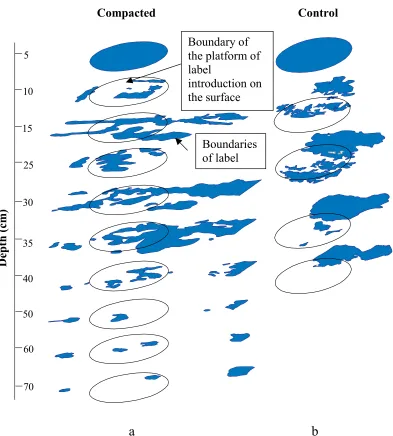
In Fig. 1 (a, b) the distributions of a label on two objects of research are given. The accumulation of water above the compacted layer is rather characteristic. The formation of the separate ‘waterways’ inside the condensed layer at a depth of 35–55 cm also attracts considerable attention. These ‘waterways’ or ‘fingers’ are maintained at a sufficient depth (Fig. 1a). On the contrary, in Grey soil with 2nd humus horizon (Fig. 1b, the control) such ‘waterways’ are not formed, and the movement of water occurs more in regular intervals, by a uniform wetting front. Therefore, in this case the depth of penetration of a label is significantly less. Even this qualitative supervision over water movement with the help of a tracer allows one to speak about the significant role of subsoil compacted layers on changes in the movement of soluble substances in the soil and about the formation of ‘the preferential flow paths’ just in this layer. Moreover, genera-ted flows have a strictly vertical form, these form and space positions vary only slightly with depth (Fig. 1a). In this case we come nearer to the ‘classical’ formation of the preferen-tial flow paths. But in our case the subsoil compacted layer
was the origin of these ‘fingers’. The ‘fingers’ were formed in filtration experiments, in soils without hydrophobic la-yers, that is, in normal agricultural soils with subsoil com-pacted layers. To our mind this phenomenon is not the same as the ‘classical’ preferential flow: this phenomenon makes itself evident in filtration experiments, in natural clay-loam soils, and the origin of this phenomenon is the spatial (verti-cal and horizontal) distribution of the soil structure (chiefly soil density).
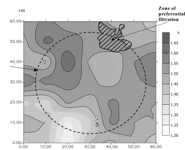
On depths investigated we have received spatial distri-bution of soil density and ways of water migration (labeled zones) in a horizontal plane. The example of such distribu-tions is given in Fig. 2. Water filtration paths, which are vi-sible from these figures, not necessarily coincide with the most friable zone. As usual, the position of the labeled zone is determined by the position of the starch zone on the upper boundary of the layer investigated. This phenomenon is especially characteristic for the deeper layers of soil with a subsoil compacted layer (see Fig. 1b).
The qualitative pictures of preferential ways of migra-tion and isoplets of distribumigra-tion do not give precise infor-mation about connections between the basic methods of the filtration of soil water and density. To display a mutual spa-tial situation of various categories of separate platforms and their densities, a number of parameters describing spatial distribution of water migration paths and ranges of density, and also the interrelation of ways of migration and spatial distribution of soil density were entered:
1. The parameter of the specific area of various catego-ries of density is (S1). For this purpose five conditional cate-gories were allocated: <1.3, 1.3–1.4, 1.4–1.5 and > 1.5 g cm–3. The specific area of each category pays off as a per-centage occupied by the given range to all the investigated area of a platform.
2. The parameter of the ‘vertical position’ of density categories is (S2). This parameter is calculated as a percen-tage of the area of coincidence of the appropriate density category of the two neighboring layers (top and bottom) to the area of a category on the top platform. This parameter specifies the ‘vertical position’ of a spatial arrangement of various zones on density.
3. The parameter of the water movement on the appro-priate category of density (S3). This parameter is calculated as a percentage of the area of the appropriate density cate-gory and is in line with the zone of preferential water move-ment. This parameter specifies the involvement of the ap-propriate category of density in water movement on a given depth.
4. The parameter of ‘vertical position’ of the preferen-tial water paths (S4). This parameter is calculated as a per-centage of the area of coincidence of the water paths of the two neighboring layers (top and bottom) to the area of a water path on the top platform. This parameter specifies the ‘vertical position’ of the preferential water paths noted by the soluble starch.
We shall consider the distribution of all these para-meters on the depths of the investigated soil with an artifi-cially compacted layer. In doing so, in surface arable hori-zons, all categories of soil density are submitted (Fig. 3a). The relative square of the density category 1.4–1.5 g cm–3is constantly increased with the depth at 50 cm 66%. The most friable (<1.3) and densest (>1.5 g cm–3) are smaller relative squares at all depths. At a depth of 30 cm, the maximum for category 1.5–1.6 g cm–3is noted which is apparently con-nected with subsoil compaction. The parameter of ‘vertical position’ of density categories (S2) has a slightly different distribution (Fig. 3b): S2 is greatest for category 1.3–1.4 g
cm–3in the top layers, but for layers 25–45 cm the gradation 1.4–1.5 g cm–3takes the most important role. The parameter of the water movement on the appropriate category of density (S3) shows that the density category 1.4–1.5 g cm–3 has the advantage of water transport (Fig. 3c). This is the category which dominates others in the relative area. It is necessary to emphasize – preferential water paths are not situated on zones of the most friable soil, but rather on the most representative within the investigated area of the soil layer. This is very important – preferential water paths are situated in zones of a density category, which keeps a vertical position on the soil profile, and ‘slightly fluctuates’.
5
10
15
25
30
50
60
70 35
40
Boundaries
of label
Boundary of
the platform of
label
introduction on
the surface
Compacted
Control
Depth
(cm
)
a
b
Accordingly, the parameter of the ‘vertical position’ of the preferential water paths (S4 – Fig. 3c) follows distribution at the depth of the parameter of the vertical conformity (S2) of the appropriate square of density category (1.4–1.5 g cm–3). Thus, for the Grey agricultural soils investigated with a sub-soil compacted layer, the spatial distribution of preferential water movement has two characteristics: (1) preferential water paths form in zones of a density category which domi-nated in square in the layer and (2) preferential water paths hold their vertical positions in categories of soil density, which retain the vertical position through the soil profile. The formation of these soil density categories is promoted by agricultural machinery compaction: compaction promo-tes the formation of homogeneous pore space on diameters, and also ‘focuses’ vertical water transport. These two cha-racteristics of soil pore space also result in the formation of preferential filtration flows in agricultural soils with subsoil compacted layers.
It permits the assumption to be made that preferential flow paths, generated in a compacted layer, maintain the orientation and form filtration of water in deeper layers. Water moves through naturally compacted sites in the bottom part of a soil profile, in spite of the fact that there is an area with a much more friable soil structure. It specifies strict flow orientation, preservation of its form during the process of filtration in deep layers and, therefore, mass
transport even in the deepest layers. This phenomenon af-fects to a great extent the classical preferential flow efaf-fects, but originates from the spatial distribution of soil porosity (different density categories and their orientation in vertical and horizontal directions) and in saturated water conditions (filtration).
The experiments also allow the generation of the following hypothetical picture of water movement in natural soils and in soil with a subsoil compacted layer. This is illustrated schematically in Fig. 4. The formation of con-centrated flows is underway in the subsoil compacted layer. Within these condensed (preferential) flow paths, water moves strictly vertically downwards in spite of the presence of natural compacted zones. The depth of such a penetration of moisture is much higher, than in natural soils. Such a movement of water and ions, formed by the presence of the subsoil compacted layer, is of great ecological importance, as these flows may cause a wide range of groundwater systems and other environmental subject pollution.
CONCLUSIONS
In scale of a soil individual (area of research about 1 m2), in conditions of moisture movement close to filtration, the following regularities of spatial distribution of density and preferential ways of water migration in Grey clay-loam soils are observed:
120 E.V. SHEIN et al.
1.20 1.25 1.30 1.35 1.40 1.45 1.50 1.55 1.60 1.65
Zone of preferential filtration
r
b cmPosition of zone of label injection on the surface
1. The filtration of water is not carried out in all soil pores, and not only at the most friable zones of soil. The main volume of water is filtered in those categories of density, which occupy the greatest soil zone proportion within the limits of horizontal space and best keep a vertical arrangement in the soil profile (‘slightly fluctuates’ through the depth).
2. An essential role in the formation of the two specified characteristics determining the spatial form of the preferen-tial ways of migration, is attributed to the subsoil compacted layer, where there is a change in density categories and the vertical position of the spatial arrangement of these cate-gories is formed.
ACKNOWLEDGMENTS
This research was partially supported by INCO COPERNICUS Concerted Action ERB IC15-CT98-0125 (DG12 - CDPE) ‘Experiences with the impact of subsoil compaction on soil nutrition, crop growth and environment, and ways to prevent subsoil compaction’ and the Russian Fund for Basic Research, grant 01-04-48066.
The authors would like to thank Prof. R. Horn (Kiel) for fruitful discussion and improvements to the English text.
REFERENCES
Beven K. and Germann P., 1981.Water flow in soil macropores. II. A combined flow model. Soil Sci., 32, 15–29.
Bouma J.A., Jongerius A., and Schoonderbeek D., 1979. Calcu-lation of saturated hydraulic conductivity of some pedal clay
soil using micromorphometric data. Soil Sci. Soc. of Amer., 43, 261–264.
Dmitriev E.V. and Hohrina T.K., 1975. About the ways of the water movement in saturated soil (in Russian). Problems of the Agriculture Science in Moscow State University, Mos-cow, 123–126.
Dmitriev E.V., Scheglov V.N., and Basevich V.F., 1985. Morphology of the water movement in saturated soil and influencing factors (in Russian). Transaction of Moscow University, 17, Pochvovedenie, 1, 31–35.
Flury M., Fluhler H., Jury W.A., and Leuenberger J., 1994. Susceptibility of soils to preferential flow of water: a field study. Water Resour. Res., 30, 1945–1954.
Hillel D. and Baker R.S., 1988.A descriptive theory of fingering during infiltration into layered soils. Soil Sci., 146, 51–56. Ritsema C.J., Dekker L.W., Hendrickx J.M.H., and
Hammin-ga W., 1993.Preferential flow mechanism in water repellent sandy soil. Water Resour. Res., 29, 2183–2193.
Shein E.V., Guber A.K., and Kuharuk N.S., 1995. Water and matter movement throw macropores in Sod-Podzolic soil (in Russian). Transaction of Moscow University, 17, Poch-vovedenie, 2, 22–32.
Shein E.V., Umarova A.B., Dembovetsky A.V., and Marche-nko X.A., 2000. Subsoil density distribution and matter movement in soils. Proc. 2nd Workshop and Int. Conf. on Subsoil Compaction, Gödöllö, 105–110.
Steenhuis T.S., Ritsema C.J., Dekker L.W., and Parlange J.Y., 1994.Fast and early appearance of solutes in ground water by rapid and far-reaching flows. Trans. 15th World Congress of Soil Science, Acapulco, Mexico, 184–203.
Van Ommen H.C., Dekker L.W., Dijksma R., Hulshof J., and van den Heuven M, 1989.Experimental assessment of pre-ferential flow path in a field soil. Hydrol., 105, 253–262.