3 (-IF
Reprinted from the 4ournal of Environmental Quality Vol. 5, no. 2, April-June 19 7 6. Copyright ©1976, ASA, CSSA, SSSA
677 South Segoe Rd., Madison, WI 53711 USA
Purchased by the Agricultural Research Service, U. S. Department of Aviculture, for official use
Guidelines for Sediment Control in Irrigation Return Flow'
D. I.. Carter'
ABSTRACT
Sediments in irrigation return flows arise mostly from erosion in furrows during irrigation, and sediment concentrations vary widely from near zero to several thousand ppm. Reducing both erosion and runoff would decrease the sediment in return flows. Tech-nology is available for reducing both erosion during irrigation and soil loss from the land, and for removing sediments from return flows. This technology is discussed, and the following guidelines are suggested.
1) Eliminate or reduce irrigation return flows when conditions permit using irrigation methods with little or no runoff. 2) Control the irrigation furrow slope so that the run is across
the steepest slope or on the contour. Decrease the slope near the end of the furrow to reduce the flow velocity and in-crease sedimentation.
31 Control the furrow stream size and make proper stream ad-justments. Adequate water measuring equipment and con-trols are essential for proper stream size control.
41 Shorten the run length.
5) Control the irrigation duration to reduce the number of irri-gations per season. Alternate furrow irrigation reduces the contact between soil and flowing water and subsequent erosion.
61 Cultivate only when necessary, avoiding excessive soil loosen-ing which increases erosion and soil loss.
71 Control tailwater by assuring that it flows slowly enough that sediments settle before the water leaves the field. Filtering through grass strips removes sediments.
El) Utilize sediment retention basins to remove sediment from return flows.
Additional Index Words: erosion control, irrigation return flow quality, irrigation control.
Drainage water returning to rivers and streams from irri-gated areas is commonly called irrigation return flow to distinguish it from other sources. Irrigation water that
t Contribution from the Agricultural Research Service, USDA, Received 28 July 1975.
2 Supervisory Soil Scientist, Snake River Conservation Research Center, Kimberly, ID 83341.
percolates through the soil and returns to a river or stream is called subsurface irrigation return flow and that passing across the land surface and entering a river or stream is called surface irrigation return flow. Many drainage streams contain both surface and subsurface return flows. This paper deals primarily with surface irrigation return flows which carry sediments from field erosion.
The 1972 Water Quality Act Amendments and their subsequent interpretation designated irrigation return flow streams as point source discharges. According to the amendments, point source discharges required permits, and to obtain these, certain quality standards must be met in a specified time period. Meeting sediment concen-tration limits is the most critical requirement for surface irrigation return flow in many areas. The required permits for point source surface irrigation return flows stimulated great interest among irrigation and canal companies and individual irrigators. Considerable resistance to the per-mits developed with many questions raised and numerous meetings held to discuss the permits, their legality, and the possibilities of meeting sediment quality standards.
The U. S. Environmental Protection Agency issued the first irrigation return flow permits to 29 irrigation com-panies in Idaho on 11 Oct. 1974. These permits generally allowed a 100 mg/liter greater sediment concentration in the return flow than in the irrigation water on an annual average basis, limited to a 200 mg/liter greater sediment concentration at any time. Some of these companies challenged the permits through formal appeals, question-ing interpretation of the amendments to include irriga-tion return flow, the probable success of meeting quality standards, and the impact of the amendments on food production from irrigated lands.
The interest in irrigation return flow quality stimulated an evaluation of presently available and needed technolo-gy for sediment control. It has emphasized the need for erosion control on irrigated lands, the sediment source in irrigation return flows. The seriousness of erosion on
rigated land has been recognized for many years. Israel-sen, Clyde, and Lauritzen (7) reported results of a 6-year erosion study in 1946 and stated that excessive erosion on irrigated lands is adverse to the perpetuation of perma-nent agriculture in arid regions. They showed that fur-rows near the head ditches had eroded from 2.5 to 10.2 cm in one season, while the lower ends of the furrows were completely filled with sediment. Conditions are similar today, 30 years later, in many furrow irrigated areas. There has been some progress towards controlling erosion on irrigated lands, but much more is needed.
SOIL LOSSES AND SEDIMENT IN IRRIGATION RETURN FLOWS
Sediment in irrigation return flows arises primarily from furrow erosion and subsequent surface runoff. Oc-casionally, erosion is increased by rainfall during or after irrigation, but rainfall of sufficient magnitude to cause erosion in arid or semiarid regions is infrequent (8). Irri-gated lands may also be eroded by runoff from snowmelt and rainfall on frozen soil or on snow. This type of erosion is essentially the same as that on nonirrigated soils, and sediment losses can be estimated by the same criteria (16, 17). Some soil eroded from irrigated lands by snowmelt or early spring rains may be deposited in drairis and subsequently picked up by irrigation return flows.
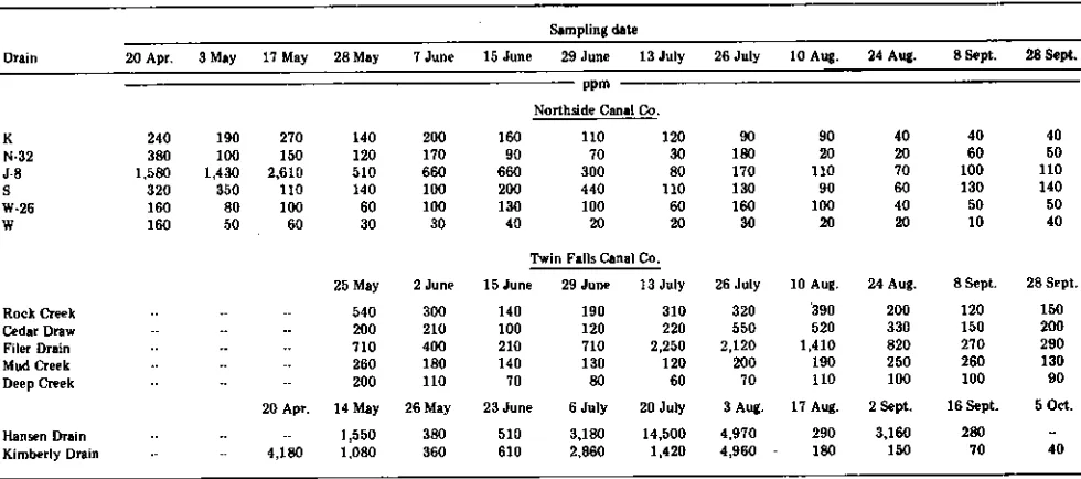
The sediment concentration in irrigation return flows varies widely with time during the irrigation season, as illustrated by recent studies of two large irrigated tracts in southern Idaho (2, 3) (Table 1). Concentrations in the Hansen drain varied from 280 to 14,500 ppm, while con-centrations in other drains were as low as 10 ppm. The seasonal soil loss from fields into drains on a 65,350-ha irrigated tract was 4.0 metric tons/ha. Most of this sedi-ment was deposited in drains requiring mechanical re-moval. The loss from an adjacent 82,030-ha tract was 1.42 metric tons/ha (2). These were net soil losses repre-senting only the sediment reaching drains in excess of that in the diverted irrigation water. Sediment in the irrigation
water entering both tracts had been subtracted, and sedi-ment in drainage and runoff water redistributed for irriga-tion was not included.
Much of the surface runoff water from fields in both tracts is redistributed to other fields. This results in ero-sion of some fields and sediment deposition in others. Sediment in irrigation water applied to fields of alfalfa (Medicago sativa L.), grass, and similar close-growing crops is filtered, and runoff from these fields is essentially sedi-ment free. In contrast, erosion may be severe in fields of
beans (Phaseolus sp.), sugarbeets (Beta uulgaris L.), and other row crops, particularly after cultivations. A field of alfalfa may gain sediment for a 3-year period and then the same field may erode and lose soil for a 2-to 3-year period when planted 2-to row crops after alfalfa. Nearly level fields generally gain sediment while steep fields lose soil. Lands operated by erosion-conscious farmers often gain sediment because of erosion control practices, whereas land operated by the less conservation-conscious farmers may erode severely. Mech and Smith (10) reported erosion losses even on established alfalfa fields after cultivation. It is important to note that sedi-ments transported from one field to another may trans-port nematodes and possibly disease organisms.
GUIDELINES FOR SEDIMENT CONTROL
When water flows over cultivated land, erosion may oc-cur. When surface runoff from eroding fields enters a sur-face river or stream it contains sediment. There would be little sediment in return flows if field erosion were eliminated. Therefore, controlling erosion in irrigated fields would also control the sediment in return
flows-Technology for controlling erosion on irrigated land is available, but complete control is difficult. Some informa-tion is also available for removing sediments from return flows. The following general guidelines for controlling sediment in irrigation return flow include practices for preventing sediments from entering return flows and for removing sediment from return flows before they enter natural rivers and streams: (i) eliminate or reduce
irriga-Table 1—Sediment concentration in surface drainage waters from two large irrigated tracts during the 1971 season 12)
Sampling date
Drain 20 Apr. 3 May 1.7 May 28 May 7 June 15 June 29 June 13 July 26 July 10 Aug. 24 Aug. 8 Sept. 28 Sept.
ppm
Northside Canal Co.
K 240 190 270 140 200 160 110 120 90 90 40 40 40
N•32 380 100 150 120 170 90 70 30 180 20 20 60 50
J-8 1,580 1,430 2,610 510 660 660 300 80 170 110 70 100 110
S 320 350 110 140 100 200 440 110 130 90 60 130 140
W-26 160 80 100 60 100 130 100 69 160 100 40 50 50
W 160 50 60 30 30 40 20 20 30 20 20 10 40
Twin Falls Canal Co.
25 May 2 June 15 June 29 June 13 July 26 July 10 Aug. 24 Aug. 8 Sept. 28 Sept.
190 310 320 390 200 120 150
120 220 550 520 330 150 200
710 2,250 2,120 1,410 820 270 290
130 120 200 190 250 260 130
80 60 70 110 100 100 90
Rock Creek Cedar Draw Filer Drain Mud Creek Deep Creek
Hansen Drain Kimberly Drain
540 300
200 210
710 400
260 180
200 110
20 Apr. 14 May 26 May
1,550 380
4,180 1,080 360
140 100 210 140 70
23 June 6 July 20 July 3 Aug. 17 Aug. 2 Sept. 16 Sept. 5 Oct.
510 3,180 14,500 4,970 290 3,160 280
610 2.860 1,420 4,960 - 180 150 70 40
Lion return flows, (ii) control the irrigation furrow slope, (iii) control the furrow stream size and make proper stream adjustment, (iv) shorten the run length, (v) control the irrigation duration to reduce the number of irrigations per season, (vi) cultivate only when necessary, (vii) con-trol taifwater by assuring that it flows slowly enough that sediments settle, and (viii) utilize sediment retention basins to remove sediments from surface return flows. Proper irrigation water management and irrigation system design arc the first requisites for reducing sediments in irrigation return flows. The listed guidelines are all in-cluded in these requisites.
Eliminate or Reduce Irrigation Return Flow
Eliminating surface irrigation return flows is often sug-gested when considering irrigation return flow quality problems. This seems to be a logical approach because there are irrigation methods without runoff. These in-clude properly designed sprinkler systems, basin irriga-tion, trickle irrigairriga-tion, and some border methods. How-ever, these methods have limitations. The energy required for sprinkler systems is high and energy resources arc limited. The capital investment is high for center pivot, side roll, and solid-set sprinkler systems, and there are labor problems associated with hand-moved systems. Serious erosion problems can result from improperly de-signed and operated sprinkler systems where the applica-tion rate exceeds the intake rate (11). Current costs for trickle systems arc too high for most crops. Basin and border methods arc limited to nearly level land. Where runoff can be eliminated by using these methods, no problems of sediment control in return flows will exist.
The recirculating or pump-back system described by Bondurant (1) is another method for eliminating or great-ly reducing irrigation return flow. This method uses a basin or pond at the bottom of the field to catch surface runoff. A pump returns the water from the pond to the top of the field, or to a different field, for reuse as irriga-tion water. Field erosion is not eliminated and mechani-cal removal of sediments deposited in the basin is re-quired, but sediment is prevented from returning to rivers and streams.
Most irrigation return flows come from furrow-irrigated lands. Therefore, controlling sediments in irrigation re-turn flows will require improved furrow irrigation man-agement.
Completely eliminating irrigation return flows would cause other problems in the irrigated west. Some districts depend upon return flows from other districts, wholly or in part for their irrigation water source. Thus, eliminating the return flow from one district may limit the supply to another. However, eliminating runoff would probably re-duce the amount of water applied, leaving more water in the stream for distribution to those formerly dependent upon runoff for supply.
Control the Slope
Land slope greatly influences erosion. Kincaid and Swanson (8), Swanson and coworkers (14, 15), and Harris and Watson (5) investigated the effects of slope on furrow erosion for both irrigated and nonirrigated land. vIech
(9) did extensive work on the effects of slope on irrigation furrow erosion. These studies showed that erosion may he expected on most row-cropped soils when slopes ex-ceed 1%. Erosion may he controlled reasonably well on slopes up to 2% if stream size is carefully controlled.
Many fields are furrow irrigated in the steepest direc-tion, which often exceeds the 0 to 2% slope prescribed for erosion control. A change in the irrigation direction could reduce erosion and sediment loss from some fields. Contour furrows are well suited for crops requiring con-siderable ridging such as corn (Zea mays L.), potatoes (Solanum tuberosum L.), and some perennials. The ridges confine the water and reduce danger of overtopping. However, short rows and turns are not compatible with use of large equipment.
Grading land to reduce the slope near the lower ends of the furrows decreases the flow velocity in the furrows, causing sedimentation in the furrows and essentially eliminating soil losses from fields (j. A. Bondurant. Personal communication and unpublished data.). This practice will not reduce erosion at the upper ends of the furrows, but will likely reduce it at the lower ends. Farmers resist this practice because the furrows fill with sediment, and flooding or lateral flow occurs if the stream size is not carefully controlled.
Control Furrow Stream Size
There is an optimum stream size for a given furrow, soil, and crop condition (9, 10). Devices that positively control the amount of water from the pipeline, flume, or ditch into each furrow are essential to effective erosion control and efficient irrigation. Valves, gates, siphon tubes, and other flow control devices permit small flow adjustments that remain unchanged until reset.
Each furrow increment functions as an infiltrating sur-face for replacing water depleted by the crop and as a conducting channel for water required to irrigate the re-maining length. The stream size decreases down the fur-row as water infiltrates. The stream size at the head must be sufficient to meet the infiltration requirements over the entire length of the row, but ideally should not exceed that amount. Such control requires careful management because the infiltration rate often changes during and be-tween irrigations.
The most erosion takes place where the flow is largest (4, 9, 10), and the largest flow in irrigation furrows is at the upper end. This contrasts with conditions under rain-fall where the stream size increases from the upper to the lower end as runoff accumulates, and more erosion takes place at the lower end. More soil may he removed from the field by rainfall than by furrow irrigation because the erosion will he most severe near the lower end of the field. Under furrow irrigation, soil eroded at the upper end of the run is often deposited near the lower end as the stream size and sediment transport capacity decreases. If the stream size is controlled to limit runoff, there will he little or no sediment in the return flow even though con-siderable erosion may take place at the upper end of the furrows.
The common practice on many furrow irrigated farms is to use a stream size that will reach the lower ends of the furrows quickly to assure uniform water distribution.
Also, if a large enough stream is used the irrigator can make water sets on a regular schedule, usually morning or evening, and not be bothered with the water during the remainder of the day while involved in other farming operations. This practice wastes both water and soil. Ex-cessive runoff does not benefit the crop, and it increases erosion and the sediment load in return flows.
A greater initial flow is often desired to get the water through the end of the furrow and allow a uniform intake time. Once the water reaches the end, the flow should he reduced or cutback to decrease erosion and runoff. If the stream size is reduced for a given water set, the excess water from the set after the cutback must he utilized in most systems with open ditches. If it is applied to an-other section of the field or to a different field, irrigation sets must be initiated several times during the day, and irrigation management becomes more complex. Hum-pherys (6) developed several systems for reducing flow in furrows after water has reached the ends. One, recently developed, seems to have good potential for reducing stream size and controlling runoff and erosion while avoid-ing split set problems (A. S. Humpherys. Personnel com-munications and unpublished data.). The system supplies water to the center point of a gated pipeline equipped with automated control valves. The entire stream is first directed to only one-half of the line until water has reached the end of the furrows receiving water from that portion, as indicated by a detector or timing device. The entire stream is then directed to the other half of the line until the water reaches the ends of the furrows it supplies. Then the water is directed to the entire length of gated pipe so that the stream size into each furrow is only half that of the initial stream for the remainder of the irriga-tion. The controls operate automatically in response to sensing or timing devices. Such an approach can greatly reduce erosion, runoff, and the sediment in irrigation flows and also solve the problem of excessive water after a cutback is made.
The stream size delivered to a farm or field is an im-portant factor in controlling stream size in furrows. Some irrigation districts do not have adequate measuring devices to measure delivery, and the measuring devices used by others need to be replaced. There is adequate technology and equipment to measure water flow and to assure a con-stant flow at the delivery point.
Shorten the Run Length
A field 300 m long may erode less if irrigated in three 100-m runs or two 150-m runs than when irrigated in one 300-m run. This is because smaller stream sizes can be used (4, 9, 10). The most practical run length is de-termined by several factors, including the infiltration rate, crop, slope, and machinery use. Farmers are reluctant to shorten run lengths because large fields can be tilled more economically with large machinery and added cross ditches to shorten the length of run interferes with tillage operations.
An alternative to cross ditches is the multiset irrigation system developed by Rasmussen, Bondurant, and Berg (12). This system utilizes aluminum or plastic pipe for distributing water at several points along the furrows, thereby effectively decreasing the run length and greatly
increasing the stream-size control and related factors. Field tests showed that this system markedly reduced erosion and runoff. The system is portable so the pipe can he removed for cultivating. Another advantage is that the system can be readily automated. This concept has great potential for sediment control in irrigation return flows.
Another factor related to both the run length and fur-row stream site is the amount and type of crop residue in the furrows. Crop residues may increase infiltration and decrease the flow velocity by physical resistance, and both functions decrease erosion. Residues can also filter sedi-ments from water. Proper crop residue management can play an important role in irrigation management and ero-sion control. In most furrow irrigated areas, the general tendency is to clean till so that there is little or no crop residue in the furrows.
Controlling the Irrigation Duration
Erosion and sediment concentrations are highest early in the irrigation period (9, 10). Sometimes, all the soil loss occurs during the first 4 hours of irrigation, even though runoff continues at a slowly increasing rate (10). These results indicate that less sediment would enter re-turn flows if fields were irrigated less often and for longer durations. Increasing the duration may increase leaching and associated nutrient losses, and decreasing the fre-quency may not be practical for shallow-rooted crops. Nevertheless, decreasing the frequency is a method of re-ducing sediment losses.
Alternate furrow irrigation is another means of con-trolling sediments in irrigation return flows. Only half as much soil surface is in contact with flowing water in alternate furrows as when water is applied to every fur-row. However, the irrigation time must he about doubled and deep percolation losses may be greater. This ap-proach is limited to soils that permit adequate lateral water movement.
Cultivate Only when Necessary
Tilling the soil contributes to erosion and sediment in return flows. Some erosion is inevitable with the first irri-gation after tillage. Mech and Smith (10) summarized re-sults from several investigations indicating that soil losses from furrows during the first irrigation after reditching of alfalfa were about 10 times greater than during the next irrigation with no intervening cultivation. Similar results were obtained with corn and other row crops. Chemical weed control and other practices that reduce cultivation should be employed.
Control Tailwater
The most important factor in controlling tailwater is to limit the amount of runoff. The smallest stream that will irrigate to the end of a furrow will add nearly as much water to the soil as a larger stream, and the amount of runoff will be much less and more easily controlled.
A common practice-in some irrigated areas is to keep the drain ditch at the lower end of the field clean, 10 to
20 cm deeper than the furrows, and at a slope steep enough so that the tailwater flows rapidly away. This practice causes severe erosion at the furrow ends, and when continued, erosion gradually moves upslope, in-creasing the slope and the subsequent erosion on the low-er 5 to 10 m of the field. As a result, many tons of soil are lost from these fields each year, and the field end be-come convex shaped. Often land forming is required to reshape the field end.
Erosion-conscious farmers keep the drain ditch at the field end small and shallow, and at a low slope so that water moves away slowly and sediments settle out before the water leaves the field. Some farmers follow excellent tailwater-control measures. One practice is to place soil checks in the drain ditch so that flows from about four furrows enter each section between checks. The tailwater drain ditch is adjacent to a larger drain ditch with sod banks for transporting drainwater from several farms. As the segments of the checked drain ditch fill slowly, the sediments settle. When the segments have filled, the water trickles slowly across the sod bank into the larger ditch. Essentially all the sediment settles and that remaining is filtered by the grass on the bank.
Another practice that seems to have potential is to plant a grass strip buffer at the lower end of the field to filter eroded soil from the water before it enters a return -flow stream. Crop residues can also serve as a sediment filter here. Another practice is to utilize tailwater con-taining sediment from row-cropped fields directly as irri-gation water for pasture or alfalfa to filter the sediment.
Utilize Sediment Retention Basins
Sediment retention basins remove much of the sedi-ment from irrigation return flows. Even though the soil lost from fields into return flows can be reduced, the need to remove sediments from return flows before they enter streams will continue for many years. Using sediment re-tention basins is a relatively expensive, partial cure to the sediment problem, not a prevention.
The increased awareness of sediments in irrigation re-turn flows caused by the 1972 Water Quality Act Amend-ments has stimulated the construction of many new sedi-ment retention basins. Robbins and Carter (13) reported that approximately 150 natural or man-made ponds larger than 0.2 ha are used as sediment retention basins an the 82,030-ha Twin Falls Canal Co. tract in southern Idaho. Many of these basins were constructed in 1973, although some farmers have used sediment retention basins for many years.
The effectiveness of simple sediment retention basins is illustrated by a typical basin catching part of the runoff from approximately 117 irrigated ha (13). The land area drained was intensely cropped to dry beans, sugarbeets, cereal grains, alfalfa, and some pasture. The soils were highly erodible Portneuf silt loam, and the slopes varied from < 1% to about 15% along the furrows. A total of 2,390 metric tons of sediment was deposited in the 0.45-ha basin during two irrigation seasons. This represents a severe erosion loss of 20.5 metric tons/ha over the 2-year period from the 117-ha area. This figure includes only the sediment removed by the basin. The sediment re-moval efficiency exceeded 80% when the sediment
con-centration exceeded 0.1% and was never below 65% dur-ing the period of operation.
Several types and sizes of sediment retention basins can be used to remove sediments from irrigation return flows. Basins can be located to receive runoff from individual fields, from entire farms, from several farms, or along ir-rigation district drainways. They can be excavated or located in a natural depression area by constructing a dike or dam with a proper outlet. The efficiency of these basins depends on their size and design in relation to the flow velocity through them, the settling depth, and other factors. The efficiency of one specially designed district drainway basin in southern Idaho averaged about 70% over three irrigation seasons. It was designed to remove at least 50% of the sediment. More information is needed about the design and operational criteria for sediment re-tention basins for different conditions.
The sediment collected in basins is a valuable resource that can be used for many purposes. Unfortunately, transportation costs from the basins to the use area may be excessive. It is important to locate basins as near the point of sediment use as possible. In many instances, natural depressions can be filled by constructing dikes or dams to form basins. Some cropping area may be Iost during the period the sites are used for sediment basins, but after these basins are filled, the drain water can be placed in controlled channels and the deposited sediment can be farmed along with adjacent farmland, thus expand-ing and combinexpand-ing fields into more economical operatexpand-ing units. Other uses of sediments include landscaping, filling depressions and old channels in fields, and increasing soil depth over bedrock. A golf course has been developed by covering basalt with sediment from one simple district drainway basin in southern Idaho.
Drainage channels sometimes serve as sediment reten-tion basins. Brown, Carter, and Bondurant (2) and Carter et al. (3) reported the effectiveness of drains in removing sediments and phosphorus from irrigation return flows on the Northside Canal Co. 65,350-ha tract. Many of these drains were constructed to a grade small enough so that the flow velocity permitted sediments to settle.
Particle size segregation takes place as sediments settle in basins or drains. Sediments remaining in suspension are in the clay size fraction, although much of the clay settles in aggregates because dispersion is seldom com-plete. A greater degree of dispersion would take place in waters of low salt concentrations, and more clay would likely remain suspended in such waters. The clay size fraction is richer in phosphorus than the larger size frac-tions, so that passing water through a sediment retention basin can give an apparent phosphorus enrichment when the phosphorus per unit of suspended material is meas-ured. However, recent studies (3) have shown that sedi-ment retention basins conserve phosphorus. Generally the quantity of phosphorus associated with the sediments that settle far exceed the quantity associated with the sediment remaining suspended.
LITERATURE CITED
1. Bondurant, J. A. 1969. Design of recirculating irrigation systems. Trans. Am. Soc. Agric. Eng. 12:195-201.
2. Brown, M. J., D. L. Carter, and J. A. Bondurant. 1974. Sedi-ment in irrigation and drainage waters and sediSedi-ment inputs
and outputs for two large tracts in southern Idaho, J. Environ. Qual. 3:347-351.
3. Carter, D. L., M. J. Brown, C. W. Robbins, and J. A. Bon-durant, 1974. Phosphorus associated with sediments in irriga-tion and drainage waters for two large tracts in southern Idaho. J. Environ. Qual. 3:287-291.
4. Gardner, W., and C. W. Lauritzen. 1946. Erosion as a func-tion of the size of the irrigating stream in the slope of the eroding surface. Soil Sci, 62:233-242.
5. Harris, W. S., and W. S. Watson, Jr. 197L Graded rows for the control of rill erosion. Trans. Am. Soc. Agric. Eng. 14: 557-581.
6. Humpherys, A. S. 1971. Automatic furrow irrigation sys-tems. Trans. Am. Soc. Agric. Eng. 14:466-470.
7. Israelsen, 0. W., G. D. Clyde, and C. W. Lauritzen. 1946. Soil erosion in small irrigation furrows. Utah Agric. Exp. Sta. Bull. 320. 39 p.
8. Kincaid, D. C., and N. P. Swanson. 1974. Rainfall runoff from irrigation furrows. Trans. Am. Soc. Agric. Eng. 17: 266-268.
9. Mech, S. J. 1959. Soil erosion and its control under furrow irrigations in arid west. Agric. Res. Serv. USDA Inform. Bull.
184. fi
10. Mech, S. J., and D. D. Smith. 1967. Water erosion under
irri-gation. p. 950-963. hi R. M. Hagan, H. R. Haise, and T. W.
Edminster (ed.) Irrigation of agricultural lands. Agron. Ser. / 1, Chapt. 48.
11. Pair, C. II, 1968. Water distribution under sprinkler irriga-tion. Trans. Am. Soc. Agric. Eng. 11:648-651.
12. Rasmussen, W. W., J. A. Bondurant, and R. D. Berg, 1973. Multiset surface irrigation system. Int. Comm. Irrig. Drainage Bull., Jan. p. 48-52.
13. Robbins, C. W., and D. L. Carter, 1975, Conservation and
use of sediment carried in irrigation runoff. J. Soil Water Conserv. 30:134-135.
14. Swanson, N. P. 1960. Hydraulic characteristics of surface runoff from simulated rainfall on irrigation furrows. USDA-ARS 41-43:90-102.
15. Swanson, N. P., and A. R. Dedrick. 1967. Soil particles and aggregates transported in water runoff under various slope
conditions using simulated rainfall. Trans. Am. Soc. Agric, Eng. 10:246-247.
16. Williams, J. R„ and H. D. Berndt. 1972. Sediment yield com-puted with universal equation. Proc. Hydraulic Div. Am. Soc. Civil Eng. 98:2087-2098.
17. Wischmeier, W. H,, and D. D. Smith. 1965. Predicting rainfall-erosion losses from cropland east of the Rocky Mountains. USDA Agric. Handbook 282, 47 p.