Volume -2, Issue-3,May–June-2016, Page No. 38 - 43
Corresponding Author: Sherya Gupta, Page No. 38 - 43
Pag
e
38
ISSN: 2455 - 1597
Automatic Accident Detection and Notification System Shreya Gupta
Email: [email protected] Abstract
Recent technological advancement and rapidly growing population have increased the demand for automobiles which in turn has increased the traffic hazards, causing immense loss of life due to poor emergency facilities. Many people die each year due improper or delayed medical care after the occurrence of an accident. There is no effective method by which the correct authorities can be informed in time so that the person’s life can be saved. This paper describes the implementation of microcontroller based accident detection and notification system which will not only detect any accident that happens but also informs the appropriate authorities immediately as soon as the accident occurs. The sensing unit contains Tilt Sensor or Accelerometer which detects the change in orientation of vehicle in case of roll-over or crash. When accident happens GPS is used to track real time location in terms of latitude and longitude and GSM is used to notify the accident via SMS containing GPS data will be sent to the pre-programmed numbers stored in the system (victim’s relatives and emergency services like hospitals, police station etc). LCD is used to display the status of the vehicle. Software program developed using AVR compiler. The proposed system aims at making vehicle more intelligent and provides situational awareness in case of an accident.
Keywords: Accident Detection, GPS, GSM, Accelerometer, ATMEGA 16, SMS.
1. Introduction
Transportation has great importance in our daily life and its development has made many of our chores much easy. But it can cause disaster to us and even can kill us through accidents. In India, an accident happens every 60 seconds and every 3.7 minutes, to be precise; a road mishap snuffs out a life. In 2008, Road Traffic Injuries ranked fourth among the leading causes of death in the world. Every year, nearly 1.3 million people die on the roads all round the globe and 20 to 50 million people suffer non-fatal injuries, with many sustaining a disability as a result of their injury. Road traffic injuries are amongst the leading cause of death in adolescents of age 15-29 years and cost countries 1-3% of the gross domestic product (GDP). If no action is taken, road traffic crashes are predicted to result in the deaths of around 1.9 million People annually by 2020 [1]. The preemption of the road accidents taking place is not possible but at least the repercussions can be reduced. Thus accident detection system using GPS and GSM has gained attention. This system automatically informs accident to the pre-programmed numbers. In this system, Accelerometer and GPS tracking system are used for accident detection. When accident occurs, this system sends short message to mobile number via GSM modem. Message will give longitude and latitude values. From these values location of accident can be determined.
© IJERGS, All Rights Reserved.
Pag
e
39
Pag
e
39
Pag
e
39
Pag
e
39
Pag
e
39
Pag
e
39
Pag
e
39
Pag
e
39
Pag
e
39
Pag
e
39
Pag
e
39
Pag
e
39
Pag
e
39
Pa
ge
39
Pag
e
39
Pag
e
39
Pag
e
39
Pag
e
39
Pag
e
39
Pag
e
39
Pag
e
39
2. Literature Survey
The first research efforts for developing intelligent or real-time automobile route guidance were begun in Japan in the 1970’s with the goal of reducing traffic congestion. Throughout the 70’s and 80’s, the Japanese government, in cooperation with industry, was continuously involved in launching initiatives which helped to mature vehicle navigation technology. Significant research activities were triggered in Europe in the late 80s and early 90s. MITI, Nissan and Fujitsu pioneered the research in this area by joining forces in the project “Personal Vehicle System” [2]. In 1996, the Advanced Cruise-Assist Highway System Research Association (AHSRA) was established among automobile industries and a large number of research centres [3]. Programs investigating the possibility of establishing an infrastructure to support widespread navigation for motor vehicles began in the U.S. as early as the late 1960’s. However, results from these studies deemed that the supporting infrastructure for such a system would be too expensive, and further study in the United States
was dropped until the 1980’s. In the late 1980‟s, the U.S. government, recognizing that parts of the country’s road system
were taxed nearly to capacity, launched a campaign to promote the application of high-tech solutions to enhance roadway efficiency. In 1995, the US government established the National Automated Highway System Consortium (NAHSC) [4], and launched the Intelligent Vehicle Initiative (IVI) in 1997. An innovative approach to increase the safety in road travel using wireless sensors and the Bluetooth protocol has been proposed. It discussed, how vehicles can form mobile ad-hoc networks and exchange data sensed by the on-board sensors [5].A new design was developed containing vehicle tracking and control system to monitor the vehicle through an android based Smartphone to achieve the idea of an intelligent four-wheeler with ability to use individual mobile hand phone as a isolated interface [6]. A SMS-based GPS tracker monitored by mobile phone is developed especially for areas where GPRS may not be available [7]. The basic mechanism is to provide the real-time location of a vehicle using GPS receiver and send this data to GSM center through the software. All this is done by the monitoring center which works as a control unit and is connected not only by optical fibre cable but also connected wirelessly through TCP/IP protocols. The monitoring center distributes the data to the client in the understandable format and it also stores the travelling records and displays the information about vehicle on electronic map through GIS system [8]. Further, a vehicular module with a GPS receiver extracts information about the real-time location of the vehicle; saves it in database and displays it on user demand on electronic map [9].Efforts are being made to design a mobile technology that uses smart phones to track the leading vehicle especially at blind turns. Thereby making Collision Warning Systems more efficient, affordable and also, portable.
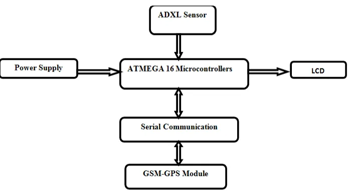
3. System Architecture
© IJERGS, All Rights Reserved.
Pag
e
40
Pag
e
40
Pag
e
40
Pag
e
40
Pag
e
40
Pag
e
40
Pag
e
40
Pag
e
40
Pag
e
40
Pag
e
40
Pag
e
40
Pag
e
40
Pag
e
40
Pa
ge
40
Pag
e
40
Pag
e
40
Pag
e
40
Pag
e
40
Pag
e
40
Pag
e
40
Pag
e
40
The hardware utilized in this system comprises of ATMEGA 16 microcontroller, ADXL335 accelerometer, GPS Module, GSM 900A and LCD. The complete system operates on a 5V dc regulated power supply. The ADXL335 can measure the static acceleration of gravity in tilt-sensing applications, as well as dynamic acceleration resulting from motion. In case, there is a vehicle roll-over the angle of the roll-over is detected by tilt sensor (ADXL335) and it is given as the input to the controller for further processing. The GPS receiver module is interfaced with USART of ATMEGA 16. It gives speed and location information. When the input is received by the controller, a message containing real-time location is sent to the pre-coded number with the help of the GSM module. The rescue team reaches the accident spot with the help of the latitude and longitude co-ordinates given in the message. An LCD display is provided to get the display of the tasks carried out. The GSM - GPS module is interfaced to the AVR controller using serial communication. All the components are interfaced precisely so that the accident detection and message sending are fully automated, so that the warning time is reduced significantly.
4. Hardware Description
A. GSM Modem
Global System for Mobile Communication (GSM) is an open, digital cellular technology used for transmitting mobile voice and data services, along with the transmission of SMS (Short Message Service). GSM modem is a mobile phone without any display, keypad and speakers. It accepts a SIM card and operates over a subscription to a mobile operator and is capable of operation in four different frequency bands but the most common are 900 and 1800 MHz. The transmission rate of GSM is 9.6 kbps. The GSM modem has capacitors and resistors for their proper working and LEDs for indicating the network status. The network status pin does depict the status of accessing network right away when we turn the circuit “ON”. To represent it we used a green LED whose status will be that it will blink rapidly when like to acquire network and blink slowly after the assessment of network. The protocol used by GSM modem for setup and control is based on the Hayes AT- Command set. AT is the abbreviation of Attention. GSM AT commands are extension commands. For example, +CMGS (Send SMS message), +CMGL (List SMS messages), and +CMGR (Read SMS messages) are extended commands. The main objective of this application is whenever accident occurs it will send message and location of vehicle which is accessed using GPS to pre-programmed number [10].
Figure3: GSM Modem
B. GPS Receiver
© IJERGS, All Rights Reserved.
Pag
e
41
Pag
e
41
Pag
e
41
Pag
e
41
Pag
e
41
Pag
e
41
Pag
e
41
Pag
e
41
Pag
e
41
Pag
e
41
Pag
e
41
Pag
e
41
Pag
e
41
Pa
ge
41
Pag
e
41
Pag
e
41
Pag
e
41
Pag
e
41
Pag
e
41
Pag
e
41
Pag
e
41
of ASCII comma – delimited message strings. ‘$’ sign is used at the starting of each message. The locations (latitude and longitude) have the format of ddmm.mmmm. i.e. degrees minutes and decimal minutes.
GGA-Global positioning system fixed data.
GLL- Geographic position – latitude/longitude.
GGA contains message ID, UTC position, latitude, longitude, north-south, east-west.
Message ID- $GPGGA that is called as protocol header[11].
C. ATmega16
ATmega16 is a low-power; 8-bit CMOS microcontroller based on the AVR enhanced RISC architecture. It is a 40 pin IC consisting of four 8-bits input-output port with some special functions. Port-A (8bit) used as input port having special functions of ADC, sensors are connected to this port to convert the analog signal in the form of digital data.
Port-D (8bit) having special serial communication features, PD0 (receiver) and PD1 (transmitter) are used for communicating with GPS and GSM.
Port-B (8bit) used as output port to connect the LCD display.
D. ADXL335
The ADXL335 is a small, thin, low power, complete 3-axis accelerometer with signal conditioned voltage outputs. It can measure the static acceleration of gravity in tilt-sensing applications, as well as dynamic acceleration resulting from motion, shock, or vibration. It measures acceleration with a minimum full-scale range of ±3 g. In this circuit it’s used as a tilt sensor to sense any change in the orientation of vehicle. ADXL335 is interfaced to the ADC 1 and ADC 2 of the ATmega 16.
E. LCD DISPLAY
l6*2 LCD is used in 8 bit data mode to display the current status of vehicle. It takes a 5V supply to power up the circuit. All the data pins of LCD from DB0 to DB7 are connected to the Port B of the microcontroller. The control pins i.e. RS, R/W and E are connected to the Port a of ATmega 16.
5. Software Description
© IJERGS, All Rights Reserved.
Pag
e
42
Pag
e
42
Pag
e
42
Pag
e
42
Pag
e
42
Pag
e
42
Pag
e
42
Pag
e
42
Pag
e
42
Pag
e
42
Pag
e
42
Pag
e
42
Pag
e
42
Pa
ge
42
Pag
e
42
Pag
e
42
Pag
e
42
Pag
e
42
Pag
e
42
Pag
e
42
Pag
e
42
yes
No
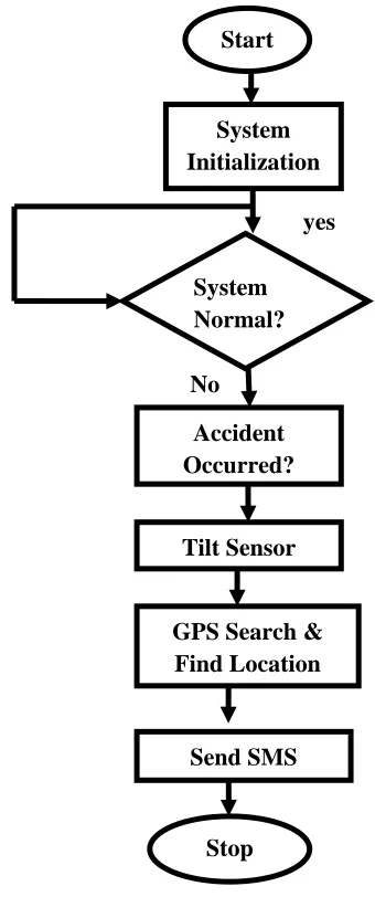
Figure 4: Flowchart of Accident Detection and Notification System
6. Conclusion
This paper deals with the system that has the advantages of small size, low cost, portability, easy and reliable operation. The design uses AVR platform along with tilt sensor; GPS and GSM, interfacing which reduces the rescue time to a large extent after the occurrence of an accident and locates the accident site accurately. The proposed system can provide an optimum solution for lack of accident location detection. Consequently, reducing the time elapsed in searching the location so that the victim can be treated as soon as possible; which will save many lives. Although this system has broad application prospects as it integrates the positioning system and medical based services yet it has the limitation of GSM network availability.
7. Future Scope
This design can be made be made more efficient by interfacing it with Vehicle Airbag System that prevents vehicle occupants from hitting against the interior objects such as the steering wheel or window, when the accident occurs. Further, a camera can be interconnected to the Controller Module; to take photograph of the accident spot which makes tracking easier and provides situational awareness.This system can be extended by using ARM processors and Arduino controllers instead of microcontroller for very fast operation of processors.
Start
System Initialization
System Normal?
Accident Occurred?
GPS Search & Find Location
Tilt Sensor
Send SMS
© IJERGS, All Rights Reserved.
Pag
e
43
Pag
e
43
Pag
e
43
Pag
e
43
Pag
e
43
Pag
e
43
Pag
e
43
Pag
e
43
Pag
e
43
Pag
e
43
Pag
e
43
Pag
e
43
Pag
e
43
Pa
ge
43
Pag
e
43
Pag
e
43
Pag
e
43
Pag
e
43
Pag
e
43
Pag
e
43
Pag
e
43
8. References
[1]. World Health Organization Road Traffic Injuries Fact Sheet No 358, March 2013. Available from: http://www.who.int/mediacentre/factsheets/fs358/en/[Last accessed on 2013 Jul 15].
[2]. S. Tsugawa and Sadayuki, “Vision-based vehicle on Japan: Machine vision systems and driving control systems,” IEEE Trans. on Ind. El, vol. 41, no. 4, pp. 398–405, 1994.
[3]. M. Bertozzi, A. Broggi, M. Cellario, A. Fascioli, P. Lombardi, and M.Porta, “Artificial vision in road vehicles,” Proceedings of the IEEE, vol. 90,no. 7, pp. 1258–1271, 2002.
[4]. Vehicle-highway automation activities in the United States. U.S.Dept of Transportation, 1997.
[5]. Hemjit Sawant, Jindong Tan, Qingyan Yang QiZhi Wang, ―Using Bluetooth and Sensor Networks for Intelligent
Transportation Systems‖, In proceeding of: Intelligent Transportation Systems, 2004.
[6]. Rajesh Borade , Aniket Kapse, Prasad Bidwai , Priya Kaul, ―Smartphone based Vehicle Tracking and Control via
Secured Wireless Networks‖, International Journal of Computer Applications, vol. 68– No.7, April 2011.
[7]. Lawal Olufowobi, ―SMS Based Android Asset Tracking System‖ 2011.
[8]. Ioan Lita, Ion Bogdan Cioc, Daniel Alexandru Visan,‖ A New Approach of Automobile Localization System Using
GPS and GSM/GPRS Transmission‖, ISSE St. Marienthal, Germany,2006.
[9]. Mrs.RamyaKulandaivel, P.Ponmalar, B.Geetha, G.Saranya,‖ GPS and GSM Based Vehicle Information System‖, IJCE, Vol.1 No.1,2012.
[10]. GSM modem URL [http://www.developershome.com/sms/atCommandsIntro.asp]
[11]. GPS URL [http://gpsd.berlios.de/vendor-docs/sirf/SiRF2-Leadtek.pdf]