Navagation System for University
Shilpa1,M.Deepika2, Spandana 3, Pravalika4Associate Professor, Dept. of ECE, Lords Institute of Engineering and Technology, Lords Institute of Engineering and Technology, Hyderabad, Telangana, India 1
B.Tech Student, Dept. of ECE, Lords Institute of Engineering and Technology, Hyderabad, Telangana, India 2,3,4
ABSTRACT: Digital electronic maps are used to track the location in outdoor and indoor environment. Most of electronic maps are useful for outdoor environment. There is no efficiency technology for search the indoor location. Many smart-phones are used to track the location by electronic map. The electronic maps may be the Google map, GPS navigation, waze and offline GPS maps. These are only useful for outdoor environment. Indoor based location tracking system can be implemented by using the Indoor Atlas Android SDK. It provides an API for developers to create application for inside building navigation. This app also useful for vision it have impaired people because the speech recognition for searched location and also include the event details in indoor based location tracking application. Using this app to find the shortest path for desired location.
KEYWORDS: Indoor plan, Navigation module, Indoor plan infrastructure
I. INTRODUCTION
Now a days most of the people using the smartphones for our daily purpose. Because the android smartphones have the memory capacities, good processing speed and higher data transfer rate. Android is Linux based operating system with java support and it comes with open source software.
Many map based android application is
available in the Google play store. Map is used to transit the users from one place to another Google map, GPS is used for finding the specific location in outdoor environment. Using this application people can easily find the location such as roads, bridges, airport, shopping malls, etc. GPS (Global Positioning System) is one of the popular navigation system in the world. But it gives higher accuracy for outdoor environment not for indoor environment.
Many university campus, shopping malls and organization are very large, so the people are difficult to find the location inside the shopping malls, university campus and organization. There is no effective features for finding the location inside the buildings. In the application, using the indoor location based services is used to find the current location of the mobile clients. Indoor Location Based Services is the extension of location based services. It is used for tracking the location inside the buildings or campus. Indoor Atlas android SDK is used for indoor navigation. The SDK offers the features like the indoor positioning with higher accuracy and obtaining floor level. In Indoor Atlas to track the desired location then update the floor details for desired location and after fixing the route inside the buildings.
II. BACKGROUND
Chattopadhyay developed the university campus navigation system based on the android platform. This application is used to find the buildings internal of the campus. For instance computer science and engineering department block can be identified by this application. Using GPS to find the desired location. It identified the buildings inside the campus but not the classroom inside the buildings. It is outdoor based map application. Using this application, to find the shortest path and update the event information.
During 2014, the mobile navigation application for Osun state university is developed. This application included Google map, Quick response scanner, android development kit and augmented reality is coupled with location based system. It provides the information about the buildings, roads and bridges. It offers information for visitors about the university facilities through the mobile devices. An application named “Campus Assistant System based on android platform”. This application gives the current location of the users with help of GPS. This have the map editor tool to edit the map and manage the campus. It provides the facility to know the starting and destination location inside the campus. Context-aware android based application is developed by combining the navigation system hardware controller which is designed to ease any mechanism by using electronic commands.
III. SYSTEM ARCHITECTURE
Fig 3.1 System Architecture
This system is based on the navigation system that is made for university that will help the new comer, new faculty and a visitor. The wifi module and the arduino is directly connected with a Ethernet.
In this system a webpage is created where different blocks are made as per the number of departments so the visitor will press the particular block where they wants to go. When the visitor press the block the relay get activated and the bulb will glow of that particular location.
1. ARDUINO MEGA 2560
• Microcontroller ATmega2560
• Operating Voltage 5V
• Input Voltage (recommended) 7-12V
• Input Voltage (limits) 6-20V
• Digital I/O Pins 54 (of which 14 provide PWM output)
• Analog Input Pins 16
• DC Current per I/O Pin 40 mA
• DC Current for 3.3V Pin 50 mA
• Flash Memory 256 KB of which 8 KB used by boot loader
• SRAM 8 KB
• EEPROM 4 KB
• Clock Speed 16 MHz .
2. 16*2 CHARACTER LCD
is very basic module and is very commonly used in various devices and circuits. These modules are preferred over seven segments and other multi segment LEDs. The reasons being: LCDs are economical; easily programmable; have no limitation of displaying special & even custom characters (unlike in seven segments), animations and so on.
A 16x2 LCD means it can display 16 characters per line and there are 2 such lines. In this LCD each character is displayed in 5x7 pixel matrix. This LCD has two registers, namely, Command and Data.
The command register stores the command instructions given to the LCD. A command is an instruction given to LCD to do a predefined task like initializing it, clearing its screen, setting the cursor position, controlling display etc. The data register stores the data to be displayed on the LCD. The data is the ASCII value of the character to be displayed on the LCD. Click to learn more about internal structure of a LCD.
3. REALAY DRIVER USING BC 547
Relay driver IC is an electro-magnetic switch that will be used whenever we want to use a low voltage circuit to switch a light bulb ON and OFF which is connected to 220V mains supply.
The required current to run the relay coil is more than can be supplied by various integrated circuits like Op-Amp, etc.
Relays have unique properties and are replaced with solid state switches that are strong than solid-state devices.
High current capacities, capability to stand
ESD and drive circuit isolation are the unique properties of Relays. There are various ways to drive relays.
4. BC547
BC547 is an NPN bi-polar junction transistor. A transistor, stands for transfer of resistance, is commonly used to amplify current. A small current at its base controls a larger current at collector & emitter terminals.
BC547 is mainly used for amplification and switching purposes. It has a maximum current gain of 800. Its equivalent transistors are BC548 and BC549.
The transistor terminals require a fixed DC voltage to operate in the desired region of its characteristic curves. This is known as the biasing. For amplification applications, the transistor is biased such that it is partly on for all input conditions.
The input signal at base is amplified and taken at the emitter. BC547 is used in
common emitter configuration for
amplifiers. The voltage divider is the commonly used biasing mode. For switching applications, transistor is biased so that it remains fully on if there is a signal at its base. In the absence of base signal, it gets completely off.
ADVANTAGES
It is very quick navigation without Human intervention.
The system gives accurate route guidance system.
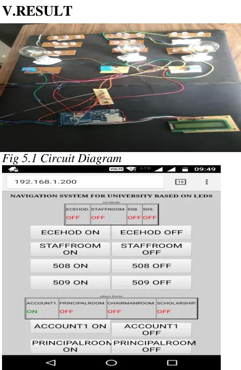
V.RESULT
Fig 5.1 Circuit Diagram
Fig 5.2 different blocks in university
In the above diagram its shows the different blocks which has been created in a webpage. When the visitor get connected with the college router and enter the IP address which is displayed in the LCD at the ground floor than this kind of blocks will open and the visitor just need to clock on the block where he or she wants to go.
The different bulbs and leds are used here for indication of the room which glows when the button pressed for that particular room.
VI. CONCLUSION& FUTURE
SCOPE
In recent years with the help of Google maps, location searching becomes a new trend, when people are not aware of their location. Google maps provide lots of functionalities like showing any location, alternative path from any location to other location and estimates time to reach the location. But it is not well developed for indoor navigation. It is very difficult to find and get shortest path from current location to any location inside university like entrance gates, departments, canteen, library, playground and parking lots etc. for the new admitted students and visitors. To reduce this pain inside the campus, implement the campus indoor location tracking system on android platform has been designed, implemented and tested successfully in this work. This application provides shortest route guide for users from his/her own location to desired location and event updates with its proper place.
REFERNCES
[1] Susovan Jana, Matangini Chattopahyay “An Event Driven University Campus Navigation System based on Android Platform”IEEE Conference on application and innovation in mobile computing,
pp-182-187, 2015 [2] C.O.Akanbi,
I.K.Ogundoyin & A.O.Lawal
[2] “Implementing University Mobile Navigation System”IEEE African journal of computing & ICT, vol 7.5, pp. 143-150 Dec-2014
[3]Mihaela Cardei, Iana Zankina, Ionut Cardei and Daniel Raviv, "Campus Assistant Application on an Android Platform.” IEEE Conference Southeast Con, pp. 1-6, 2013
[4]Piyanuch Silapachote, Ananta Srisuphab, Rasita Satianrapapong, Warat Kaewpijit and Nuttaporn Waragulsiriwan, “A
Context-Aware System for Navigation and
Information Dissemination on Android Devices.” IEEE Conference Region 10, pp. 1-4, 2013
[5]HUANG Jiejun, Zhan Yunjun, CUI Wei,
YUAN Yanbin and QI Peipei,
"Development of a Campus Information
Navigation System Based on GIS.”
International Conference on Computer Design and Applications, vol. 5, 2010
[6] S.Thongthammachart and H. Olesen, “Bluetooth Enables Indoor Mobile Location Services.” IEEE Semiannual Vehicular Technology Conference, 2003
[7]N. Chadil, A. Russameesawang, P. Keeratiwintakorn, “Real-Time Tracking Management System Using GPS, GPRS and Google Earth.” International Conference on ECTI-CON, 2008
[8] Yang Yang, Jianhua Xu, Jianghua Zheng
and Shouyi Lin, "Design and
Implementation of Campus Spatial
Information Service Based on Google Maps." International Conference on Management and Service Science, pp 1-4, 2009
[9] Mohamed Attia, Adel Moussa, Naser EI- Sheimy, “Map Aided Pedestrian Dead Reckoning Using Buildings Information for Indoor Navigation Applications.” Mobile Multi-Sensor Systems Research Group, Vol. 4, pp 227-239, 2013
[10] G. Glazer, et al., “Semi-Autonomous Indoor Positioning Using MEMS-Based Inertial Measurement Units and Building
Information, “6th Workshop on Positioning, Navigation and Communication, Hannover, pp. 135-139, March 2009
AUTHORS
E.shilpa E.Shilpa presently, working as Assistant Professor, Department of ECE, Lords Institute of Engineering andTechnology, Telangana India. Her research interests are in Microwave engineering, radar engineering and wireless mobile communications
..
MandaDeepika presently pursuing B.Tech 4th Year inLords Institute of Engineering andTechnology,Hyderabad, Telangana India.
V.Spandana presently pursuing B.Tech 4th in Lords Institute of Engineering and Technology, Hyderabad,Telangana India..
K.Pravalika presently pursuing B.Tech 4th Year in Lords Institute of Engineering and