1-1-1999
Gender differences in navigating virtual worlds
Madhumathi Madhumathi
Iowa State University
Follow this and additional works at:https://lib.dr.iastate.edu/rtd
This Thesis is brought to you for free and open access by the Iowa State University Capstones, Theses and Dissertations at Iowa State University Digital Repository. It has been accepted for inclusion in Retrospective Theses and Dissertations by an authorized administrator of Iowa State University Digital Repository. For more information, please [email protected].
Recommended Citation
by
Madhumathi Sakthivel
A thesis submitted to the graduate faculty
in partial fulfillment of the requirements for the degree of MASTER OF SCIENCE
Major: Biomedical Engineering
Major Professor: Dr. Patrick E. Patterson
Iowa State University
Ames, Iowa
1999
Graduate College Iowa State University
This is to certify that the Master's thesis of
Madhumathi Sakthivel
has met the thesis requirements of Iowa State University
TABLE OF CONTENTS
LIST OF FIGURES
LIST OF TABLES
CHAPTER 1 INTRODUCTION
1.1 Virtual Reality
1.2 Navigation in "Real" and "Virtual" Worlds 1.3 Men and Women in Real World
1 .4 Motivation 1.5 Terms Used
1.5.1 Navigational Knowledge 1.5.2 Wayfinding
CHAPTER2. BACKGROUND
2.1 Virtual Reality in Medicine 2.2 Navigation
2.3 Wayfinding
2.4 Wayfinding Strategies
2.5 Gender Differences in Real world 2.6 Socio-cultural Differences
2. 7 Video Games and Gender
CHAPTER 3. VIRTUAL ENVIRONMENT FOR NAVIGATION
3.1 lmmersive Environment-The C2 3.2 Devices
3.2.1 Crystal Eyes 3.2.2 Wand
3.3 Virtual Reality Model
CHAPTER 4. EXPERIMENTAL SETUP
4.1 Subjects 4.2 Process
4.2.1 Orientation
4.2.2 Pre Experimental Questionnaire 4.2.3 Practice
4.2.4 Task Fulfillment
4.2.5 Post Experimental Questionnaire
CHAPTER 5. RESULTS
5.1 Data Analysis 5.2 Predictive Models
5.2.1 Performance Measures (Output Variables) 23 5.2.2 Performance Predictors Selection (Input variables) - Stepwise
Regression 23
5.2.3 Performance Predictors Selection (Input variables) - Best Subsets
Regression 24
5.3 Comparative Models 24
5.3.1 Two sample T-Tests 24
CHAPTER 6. DISCUSSION 27
6.1. Predictors of Performance 27
6.2. Cqmparitve Performance 29
6.2.1. Self Assessment 29
6.2.2 Performance 30
6.2.3 Reaction 32
6.2.4 Strategies 33
6.3 Interesting Suggestions & Comments 34
CHAPTER 7. CONCLUSIONS 36
7.1 Future Work 37
APPENDIX A: CONSENT FORM 39
APPENDIX B: QUESTIONNAIRES 41
APPENDIX C: EVALUATION DURING THE EXPERIMENT 46
APPENDIX D: SAMPLE ROUTE TAKEN 48
APPENDIX E: STATISTICAL DATA 49
LIST OF FIGURES
Figure 2.1. Integration of virtual environment and intelligent training systems 5
Figure 2.2. Using VR to learn Laproscopy 6
Figure 3.1. Virtual reality setup 13
Figure 3.2. Central campus of Iowa State University 16
LIST OF TABLES
Table 5.1: Significant predictors of performance - Stepwise regression 24 Table 5.2: Input Variables - Best Subsets regression 25 Table 5.3: Significant predictors of performance - Best Subsets regression 25 Table 5.4: Summary of notable mean differences between men & women, 26
ABSTRACT
CHAPTER 1. INTRODUCTION
Technological advance in the field of medicine is increasing in an exponential fashion. Training the medical providers in many innovative procedures and new devices is increasingly becoming a very complex and challenging task [1 ]. Virtual reality may play a revolutionary role in anything from student training to surgery or rehabilitation without jeopardizing the patients while enhancing the medical personnel's performance [2]. Simulators can be used in situations where the equipment is not available or is too expensive to be used for training.
1.1 Virtual Reality
Virtual Reality (VR) has been described as "a magical window onto other worlds from molecules to minds." Virtual reality makes use of computer simulated virtual worlds in which humans interact for the purposes of learning, enhancing skills, and entertainment. Virtual reality makes visualization of complex domains possible. Unlike conventional computer systems, virtual reality makes use of immersion effects that rely on sound and tactile feedback together with 30 visualization to provide complete sensory feedback to the human brain. Virtual reality applications have become popular in multiple domains, such as surgical operations, complex model visualizations, skills training and product development, due to cost savings and flexibility.
1.2 Navigation in Real and Virtual Worlds
orientation changes, etc. Even in the real world, navigating is a complex task where
humans use multiple knowledge sources, such as use of landmarks, routes, primary
survey knowledge, secondary survey knowledge (e.g., maps) and navigational
space chunking, for effective navigation [4].
1.3 Men and Women in Real World
Another interesting phenomenon related to navigation is how women and men
differ in their spatial abilities and the strategies they use during navigating and
wayfinding. There have been theories that postulate men pay more attention to
direction than women during navigation [5,6]. Additionally there have been
experiments demonstrating that men are less inclined to use spatial aids such as
maps than women [6]. While this phenomenon is in it of interest in the real world, in
virtual worlds such differences are crucial in designing effective navigational aids.
To our knowledge, there has not been much study of the gender differences in
exploring virtual worlds.
1.4 Motivation
Transfer of training from a virtual environment to the physical world is being
used in many fields [7]. Wayfinding in real world is a complex task involving
decision-making. Navigation in large virtual worlds is very similar. In the real world,
men and women use different approaches and methods to reach a destination, either by looking at the map, keeping track of the direction in which they are
travelling, asking people for directions, etc [5]. The motivation behind this research
is to study the navigational aspects of men and women in large virtual worlds as an
aid in understanding gender related differences in performance. It is our hope that
such studies would greatly enhance gender sensitive design of effective virtual
worlds. It could also lead to making virtual reality an effective tool for precision
1.5 Terms Used
1.5. 1 Navigational Knowledge
There are two different types of navigational knowledge, procedural or route
knowledge and survey knowledge.
1. Procedural or route knowledge: This type of knowledge is gained when a person finds his/ her way from point A to point 8 successfully by using a
sequential set of steps to reach the destination. Often the directions are
referenced with respect to the current location point. A person navigating
using procedural or route knowledge may not be aware of new and alternate
routes or short cuts.
2. Survey knowledge: This type of knowledge makes use of outside or bird's
eye view of the navigational terrain that may be gained by exhaustive
exploration of multiple routes from point A to point 8. When survey knowledge is by personal experience through exploration, it is referred to as
a "primary" experience. [8]. On the other hand secondary survey knowledge
may also be inferred by making use of navigational aids such as maps and
pictures.
Primary survey knowledge is achieved after a good knowledge of the routes and
links to the destination are known, allowing alternate routes to be inferred and
straight-line distances between landmarks determined. When using secondary
survey knowledge, as though the subject knows the landmarks, he or she may not
judge the exact distance between the landmarks and their actual location
accurately.
1.5.2 Wayfinding
Wayfinding is the process used to orient and navigate with the overall goal to
accurately relocate from one place to another in a large-scale space [9]. It is also
and to recognize the destination when reached. Downs and Stea [1 O], proposed that this is done in four steps:
1. Orientation: Determining where one is in respect to nearby objects and the
target location.
2. Route Decision: Choosing a route that will get one to a destination.
3. Route Monitoring: Monitoring the route one has taken to confirm that one is
on the correct route and is going in the right direction.
4. Destination Recognition: Recognizing that one has reached the correct
destination, or a point nearby.
To complete a task using the above four steps successfully, a person should be
CHAPTER2. BACKGROUND
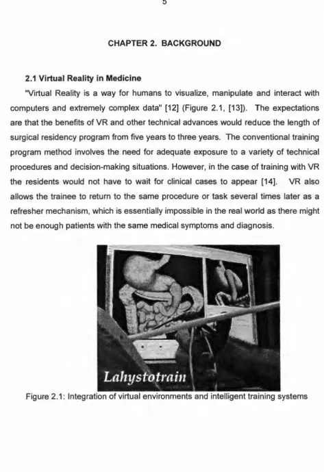
2.1 Virtual Reality in Medicine
"Virtual Reality is a way for humans to visualize, manipulate and interact with
computers and extremely complex data" (12] (Figure 2.1, (13]). The expectations
are that the benefits of VR and other technical advances would reduce the length of
surgical residency program from five years to three years. The conventional training
program method involves the need for adequate exposure to a variety of technical
procedures and decision-making situations. However, in the case of training with VR
the residents would not have to wait for clinical cases to appear (14]. VR also
allows the trainee to return to the same procedure or task several times later as a
refresher mechanism, which is essentially impossible in the real world as there might
[image:13.588.59.533.56.746.2]not be enough patients with the same medical symptoms and diagnosis.
VR is being looked upon as a tool to measure technical competence for both new and older surgeons. For new surgeons it is helpful to know if they are competent enough to handle real life situations (Figure 2.2). As surgeons age, manual dexterity could decline and VR could be used to assess their skills objectively. There are on going projects in integration of virtual environments and intelligent training systems for Laproscopy/ Hysteroscopy Surgery Training [7]
There are three seminal areas in which research is directed in order to fully exploit the advantages of VR in medicine [15]:
• Education. Anatomy and surgical procedures can be taught with better results. VR can be used not only as an educational tool, but also as the method of gaining access to needed information. With a computer interface, a virtual cadaver becomes the anatomical "index".
• Medical planning and training. For example, planning and training during disaster and mass casualty (battlefield) situations may be simulated using VR.
[image:14.585.186.427.500.668.2]• Virtual prototyping. VR can be used to support rapid development of medical equipment, instruments, and operating rooms. Staffs can be "walked through" and test new designs prior to manufacture.
2.2
NavigationNavigation and Wayfinding in Virtual Reality by Glenna A Satalich [4] focused
on spatial ability, procedural knowledge (orientation, route estimation), survey
knowledge and wayfinding under different modes of exploration. Fifty subjects were
scored under different levels of usage of a map during task fulfillment, such as being
allowed to view the map before the task and during the task, or not being allowed
access to the map during the task. The spatial ability scores in the
Guilford-Zimmerman test showed that people did worse with maps than without maps.
However, orientation task results indicated that on the average people who studied
the map before hand were more accurate (nearly 14%) in pointing the direction of
the landmarks. People who made use of maps also did better in route estimation.
When the people in the control group, who were given the map with no direct
experience, were compared to the people who explored the virtual environment
before hand, it was found that the people who were exposed to the virtual
environment either performed equivalently or worse than the control group. Satalich
concludes that the "VR experience was a distraction; not because VR is inherently
poor training medium, but because it was simply unfamiliar". The results of her
study also indicate that in some cases a map during exploration may have interfered
with learning.
2.3Wayfinding
Literature related to wayfinding shows that receiving directions through signs or
by verbal clues are more effective than using maps when finding a goal. Prior work
has been conducted to study gender-related differences in spatial skills in the real
world [5, 17] and how men and women approach video games [16].
Passini defines spatial orientation as "a person's ability to mentally determine
his position within a representation of the environment made possible by cognitive
maps" [17]. The sense of orientation is equated with the sense of direction, that is
independently of one's location in space. Not everyone has confidence in his/her
ability at this task. Some people rank themselves as having a good sense of
orientation, while others admit that their sense is not always good and yet others
claim that they lack it altogether. To complete a wayfinding task, i.e. to reach the
destination from an origination point, a person must have enough environmental
information from looking at a map, or prior knowledge, or asking someone, etc. Then
the person makes wayfinding decisions that will take the person from start to finish.
Passini, when talking about Interpreting some wayfinding curiosities talks about how
passengers have more difficulty finding the way than a driver of the automobile,
because the driver of the automobile gains more coherent understanding of what is
where. According to him, women often experience more difficulties with wayfinding
than men, possibly due to the more passive role society has imposed on them. Other wayfinding literature indicates that receiving directions verbally is
advantageous when trying to find a goal.
2.4 Wayfinding Strategies
Darken and Sibert [3] present an analysis of searching behaviors observed in
applying real-world wayfinding principles in virtual worlds. In this experiment they
classify the wayfinding task into three primary categories:
1. Naive search: Where the navigator had no prior knowledge of the target and performed an exhaustive search.
2. Primed search: Where the navigator knows the location of the target.
3. Exploration: Where the navigator does not have a specific target to be
reached.
The subjects were asked to execute five na·ive searches followed by one primed
search. The overall goal was to execute an efficient and organized search in
locating the five targets and getting back to the starting location (the home target).
The navigational terrain simulated was a marine territory that consisted of
remember the location they had visited, so that they could draw the map once they had finished all their tasks. Subjects found it hard to orient themselves because of the lack of suitable orientation cues. When a navigational grid was provided, it increased the performance and ability to extract spatial information. The subjects did a much better job when they were given maps or a map-grid combination.
Darken & Silbert conclude [3] that the lack of directional cues and spatial organization in a group without any navigational assistance led to ineffective search strategies and frequent disorientation. Navigational performance was superior when use of maps alone or in combination with grids was compared to the use of only grids or no navigational assistance. This work also showed that real-world design principles extended to virtual worlds improved the performance of navigation tasks.
2.4Gender Differences in Real World
work by Baenninger suggests that women's sense of direction improved more from the use of maps than that of men.
Studies in the real world also show that men excel in rotation tasks; women take significantly longer than men and make significantly more error [5]. An example is a test in which the subject must decide whether pairs of drawings of geometric designs (usually asymmetrical stacked cubes) are of the same or different shapes. The degree of rotation of the cubes varied from 20 to 180 degrees. Also boys outscored the girls at every age [5] in the "Road-map test of direction sense". This simple test was based on outline map of city streets and was conducted among 7 to 18 year-olds. The subject was asked to imagine himself/ herself following a standard, marked route, and without turning the map tell whether each turn is to his/ her left or right. A typical finding in Harris's study was that males performed better. He attributes this to many factors including socio-cultural differences, life experiences, anatomical, and physiological differences.
2.6 Socio-cultural Differences
Harris [5] describes how men and women differ in their spatial skills in every day life taking into consideration various aspects like socialization, life experiences and neurological models in the real world. The data indicated that self-ratings and performance were related. When a task of tracing one's way in a maze was conducted, the gender difference favored males in both speed and accuracy. There are also reports of gender difference in college freshmen's spatial knowledge of their campus [5]. After 3 weeks in residency, men recalled and also recognized significantly more campus buildings. There was no difference however in the knowledge of routes or of the configuration of the campus.
men who are candidates for the rigorous and extended training needed to be a
navigator. Demonstrations show that special training can bring women close to or at
the male level of performance, indicating "strong evidence that sex difference in
spatial ability are (in large degree) a product of differential training". Harris suggests
in his conclusion that " if there are gender differences in style or strategy of spatial
analysis, their roots lie in the early infancy and childhood". Boys spend most of their
time in their early childhood analyzing the spatial features of their environment, while
girls become increasingly skillful in expressive language skills.
2.7 Video Games and Gender
It is found that young boys play video games more often than girls do, both at
home and in arcades [18]. There is evidence in prior works that indicate an
existence of gender differences in children's video game interests [19). Research in
the field of gender differences in video games [20) indicates that it is widely believed
that the violent content of many video games is a major factor in girls' lack of interest
in video games [21]. Since most of the popular video games contain violence like
Doom, Quake etc., girls are inhibited and do not devote as much time playing and
learning to perfect their skills in video games. Studies in computer game design and
game preferences suggest that girls are less enthusiastic than boys about the
thematic embedding of good versus evil story narratives. Nor do they like the violent
feedback that normally accompanies these themes [16]. Recent research in video
game-playing performance of girls and boys found that repeated play exposure
attenuated preexisting difference [22).
The research described in this thesis, focus on the gender differences in
navigating large virtual worlds. Prior research, which focussed on gender
differences in navigation, was conducted in real world settings or studied video
game playing. Studies that involved navigation in the virtual world were more
focussed on finding effective ways to improve navigational aids for the subjects.
the virtual world due to gender differences or how to optimize navigational aids to address genders related differences. This study addresses the following possible gender differences:
• the navigation strategies used • wayfinding performance • sense of direction and
• reaction to the virtual environment.
The performance measures used were factors:
• the time taken to complete the given wayfinding task
• the number of wrong turns before reaching final destination • the number of times the subject got lost
• the number of references to the map during task fulfillment • ease of handling the wand
• strategies used and • distance travelled.
CHAPTER 3. VIRTUAL ENVIRONMENT FOR NAVIGATION
3.1 lmmersive Environment - The C2
The C2 is a device for immersion into a synthetic environment [23]. It has four
stereoscopic walls (three-dimensional) and a three-dimensional sound system.
Using this device, a user is able navigate through and manipulate virtual worlds.
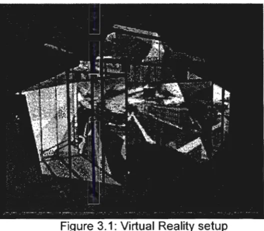
The setting consists of a 12ft X 12ft X 9ft cube (Figure 3.1) with rear-projected
screens to the left, right, and front. The floor is also used as a projection area from
an overhead projector. The computer-generated images are projected onto the walls
and the floor of the cube. There are four projectors and seven mirrors, two for each
wall and one for the floor. The mirror for the floor is mounted near the front of the
structure so that any shadows are cast behind the users, out of their normal field of
[image:21.585.164.429.354.586.2]view.
Figure 3.1: Virtual Reality setup
A magnetic tracker is used to monitor the user's position and orientation. This
maintains the user's correct perspective. It is used to calculated a true stereoscopic
view while allowing one to move into and around objects that appear within the
Stereoscopic perception is achieved using lightweight Crystal Eyes shutter glasses.
Three-dimensional sound is also used to immerse the users.
3.2 Devices
3.2. 1 Shutter Glasses
30 depth perception is achieved using shutter glasses. The computer renders a
view for both the left and right eyes, taking into account the distance between a
standard person's eyes. The two views are then shown alternately on the screen.
The glasses are synchronized to the display and shuttered close and occlude the
vision to one or the other eye alternatively at a rate of
60
cycles per second.Infrared transmitters synchronize the glasses with the projectors. The brain
registers a quick sequence of left and right eye images thus giving the depth
perception effect [24].
3.2.2 Wand
Interacting with the virtual environment is done through various devices, such as
OataGloves, joystick like wands, actual steering, etc [2]. In this experiment, we used
a 3-button wand to navigate through the large virtual world. The wand helps achieve
various degrees of freedom in the virtual world. Wand along with the 30 glasses
helps the subject to explore the virtual world without moving from his/ her physical
location. It allowed the subject to walk in the virtual world using the controls to start,
stop, reverse and reset the experiment to the starting point
3.3 Virtual Reality Model
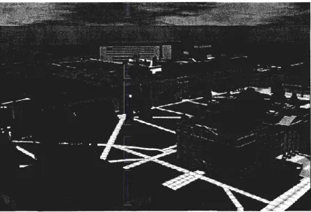
The environment used in this experimental setup is the virtual campus of Iowa
State University. The virtual campus was chosen as the experimental world since it
is a large virtual world offering sufficient navigational challenges. Also the campus is
familiar to varying degrees to the subjects in this experiment. Familiarity with the
campus allowed the subjects to exhibit multiple strategies in navigation including
the campus had been chosen, it would have been difficult to study performance
using primary survey knowledge. No training was provided in the real world campus
as part of this experiment.
The preexisting model of the virtual campus has all the buildings of the central
campus, landmarks, and sidewalks (Figure 3.2). It has approximately 50,000
triangles and 50 level of detail nodes. The campus was modeled using on an SGI
Onyx RE2 and can be viewed in real-time using IRIS Performer. The environment
was initially developed as a training test bed for VR researchers. It has also been
used for experimental interface development, architectural reviews, interactive
student orientation, and real-time walkthroughs. A major difference between the real
campus and the virtual campus is that the virtual campus has fewer trees. The
entire model was expanded by adding in the building name boards conveniently
along the sidewalks and near building entrances (identical to those on the real
campus). Street signs are not present in the virtual campus.
The name boards were designed using Mutligen II Visual database modeling
system. We looked at alternate methods to capture the name boards as they
appear on the real campus and decided to use digital pictures of the name boards
rather than taking regular pictures that would have to be scanned in later. The digital
pictures were edited and cropped to shape using PhotoShop. The exact
measurements of the name boards from the real world were taken and polygons
were built to reflect the same measurements. These were inserted into the virtual
campus and adjusted for the exact locations. The file was converted into the format
needed to run it on C2 and tested. The images were resized to 256 X 256 jpg
CHAPTER 4. EXPERIMENTAL SETUP
4.1 Subjects
A total of 56 volunteers participated in the study. There were equal numbers of
men and women chosen mostly from the Iowa State University student population
so that they would posses varying degrees of primary survey knowledge [25] and/
or secondary survey knowledge [26]. Familiarity of the subjects with the campus
varied to a large degree (as measured by the number of years spent on the ISU
campus). The subjects came from different disciplines ranging from engineering to
pure sciences. This was done to capture a wide spectrum of socio-cultural, skills
and behavioral pre-dispositions. The subjects ranged from 19 years to 55 years.
Steps were taken to ensure that the subjects were physically fit and were
comfortable entering the virtual environment.
4.2 Process
The experimental process consisted of five steps:
• Orientation
• Pre experimental questionnaire
• Practice
• Task fulfillment
• Post experimental questionnaire.
The entire procedure took anywhere from 45 minutes to 2 hours per subject,
depending on the subject's ability to complete the task.
4.2. 1 Orientation
The orientation step was used to introduce the subjects to virtual reality
technology. Here the subjects were given a short introduction about virtual reality,
its history, recent advances, and real world applications of VR in areas like training,
modeling, and enhancing human understanding. Then the equipment used in the
explained. This includes how the immersion effect is achieved using sensory feedback. This was also intended to make them comfortable with the equipment. The task of navigating in large virtual worlds was explained as the object of the study without emphasizing our interest in gender differences.
4. 1.2 Pre Experimental Questionnaire
At the end of the orientation, the subject was asked to sign the consent form (Appendix A), which indicated the purpose of the experiment, the time estimate of the whole experiment, a brief explanation of the different stages in the experiment, and the discomforts related to the experiment. The subjects are then asked to fill out the preliminary questionnaire (Appendix 8). The pre questionnaire focused on collecting general information about the subject. The details collected were based on three major categories.
• General Information which included age, gender, physical fitness, near/ far sighted, number of years of schooling, years on ISU campus.
• Computer and game playing khowledge and exposure indicating prior experience with playing computer games (non spatial, 2 dimensional, 3 dimensional), comfort level with computers, games normally played, prior experience with CAVE or any other virtual environment/ device.
• Navigational strategies the subjects used most often to find his/ her way around in a new place in the real world and whether he/ she drove a car. Subjects were also asked to make a self-assessed ranking score in navigation.
4.2.3 Practice
In the practice step, the subjects were introduced to the virtual reality setup. Through live demonstrations, they were made familiar with how the wand works and the different controls that would make them move forward, accelerate, stop, and go in the reverse direction as needed. They were also provided with a map of the central campus with no markings (without any target destinations marked) on it, so that they could refer to the map in order to orient themselves, if needed, during the practice session. Each subject was given 10 minutes to practice with the navigational gear and to get accustomed to the virtual world. The subjects were also told that they could stop at anytime if they felt nauseated or sick.
4.2.4 Task Fulfillment
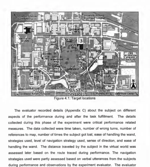
During the task fulfillment step, the subjects were given a map of the central campus of ISU with their targets marked on the map. The task was to find the 4 target buildings on the virtual campus in the sequence that was indicated on the map (Figure 4.1) before returning to the starting point. The targets were the same for all the 56 subjects.
The subjects were instructed to think aloud as they navigated the virtual world. This was done so that the evaluator can infer the subject's mental process and his/ her plan of action during navigation including their assessment of their position and performance during task fulfillment. The evaluator also monitored and traced the path taken by the subjects when navigating towards target destinations on individual maps (Appendix C). During the performance, the subjects were allowed to make as many references to the map as needed. Subjects were timed and, if needed, encouraged to speak out as they performed.
During the navigation, if the subject was totally lost and could not use the map or the nearby land marks to identify the current location, the subject was shown his/ her current location on the map. After locating all the targets and returning to their
Figure 4.1: Target locations
The evaluator recorded details (Appendix C) about the subject on different
aspects of the performance during and after the task fulfillment. The details
collected during this phase of the experiment were critical performance related
measures. The data collected were time taken, number of wrong turns, number of
references to map, number of times the subject got lost, ease of handling the wand,
strategies used, level of navigation strategy used, sense of direction, and ease of
handling the wand. The distance traveled by the subject in the virtual world was
assessed later based on the route traced during performance. The navigation
strategies used were partly assessed based on verbal utterances from the subjects
during performance and observations by the experiment evaluator. The evaluator
also noted the strategy the subject used to reorient himself/ herself, whether they
[image:28.585.43.573.68.658.2]where they could find where they were on the map, etc. Their sense of direction was estimated based on whether they knew their direction at any given point on the virtual campus (as indicated by the verbal utterances). If needed, the evaluator quizzed the subjects about their current direction/ location during performance.
The following distinctions served as primary categories in classifying the navigation strategies used.
• Looked once at the map, determined the route between 2 buildings and followed it
• Remembered the location of the destination buildings and navigated based on memory.
• Referred constantly to both the map and virtual campus.
• Formulated a mental view of the landmarks in-between and navigated using landmark recognition.
The level of sophistication in navigational strategy, sense of direction, and the ease of handling the wand were assessed by the evaluator.
4.2.5 Post Experimental Questionnaire
The post questionnaire (Appendix B) was used to collect information similar to the pre experimental questionnaire. The information was divided into two major categories related to experience with the virtual environment and performance during task fulfillment.
Performance related information collected was self-appraisal scores of
performance, information regarding the level of concentration that was achieved by
the subjects during target finding, the effect of surrounding objects in the virtual
world during wayfinding, and navigational strategies used by them. Suggestions for
CHAPTERS. RESULTS
5.1 Data Analysis
Of the 54 subjects (26 men and 28 women), two women reported simulator
sickness and could not complete the experiment. The data from these two subjects
were not used for the analysis. All statistical analysis of the data was conducted
using the Minitab statistical package.
5.2 Predictive Models
5.2.1 Performance Measures (Output Variables)
The following variables were selected from the observed data as an indication of
performance in the navigation and wayfinding task assignment (Table 5.1)
• Time to locate all targets and return to start location
• Distance traveled in locating all targets and returning to start location
• Number of wrong turns during task fulfillment
• Number of times the subject got lost during task fulfillment
5.2.2 Performance Predictors Selection (Input variables) - Stepwise Regression
Since a large number of independent variables could have influence the
performance, stepwise regression tests were performed to select the most
significant predictor variables for each of output performance variables with the
threshold 4.0 to enter and 4.0 to remove. The output of the stepwise regression test
is provided in Appendix E.
5.2.3 Performance Predictors Selection (Input variables) - Best Subsets Regression
The following list of independent variables was used as a possible candidate set
of predictor variables for selection using best subsets regression technique (Table
Table 5.1: Significant predictors of performance - Stepwise regression Performance Significant predictors (ordered from most to least Variables significant) : (+)I(-) - Positive I negative correlation
with output variable.
Time Number of map references(+), Comfort with VR (-),Years of
Schooling (+), Way you navigate - Maps(-), Familiarity with Campus(-)
Distance Years of Schooling(+), Familiarity with Campus(-)
Wrong turns Sense of Direction(-), Gender - Male(+), Age(+)
Times lost Familiarity with Campus(-), Age(+), Tendency to get lost(-)
Table 5.2: Input Variables - Best Subsets regression
Age Way you navigate - Landmarks
Gender Way you navigate - Directions
Years of Schooling Way you navigate - Others
Years at ISU campus Drive a car
Familiarity with campus Number of Map references
VR Experience Strategy - Map once and go
Comfort with VR Strategy - Remember and go
Navigation (Self) Strategy - Map often
Tendency to get lost (self) Strategy - Remember Landmarks
[image:32.587.66.497.350.572.2]Table 5.3: Significant predictors of performance - Best Subsets regression
Performance Significant Predictors (unordered), Using Cp criterion of
Variables a small Cp value and Cp near (p+1)
Time Years of schooling, Comfort with VR, Navigation (Self), Way you navigate - Maps, Number of Map references
Distance Age, Gender, Years of Schooling, Years at ISU campus, Sense of Direction
Wrong turns Gender, Years of Schooling, Sense of Direction Times lost Age, Familiarity with Campus, Sense of Direction
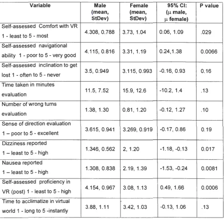
5.3 Comparative Models: Two sample t-Tests
Two sample t-Tests were performed to find the statistical difference in
Table 5.4: Significant mean differences between men & women
Variable Male Female 95%CI: P value
(mean, (mean, (µmale,
StDev) StDev) µfemale)
Self-assessed Comfort with VR
1 - least to 5 - most 4.308, 0.788 3.73, 1.04 0.06, 1.09 .029
Self-assessed navigational
ability 1 - poor to 5 - very good 4.115, 0.816 3.31, 1.19 0.24, 1.38 0.0066
Self-assessed inclination to get
lost 1 - often to 5 - never 3.5, 0.949 3.115, 0.993 -0.16, 0.93 0.16
Time taken in minutes
evaluation 11.5, 7.52 15.9, 12.6 -10.2, 1.4 .13
Number of wrong turns
evaluation 1.38, 1.30 0.81, 1.20 -0.12, 1.27 .10
Sense of direction evaluation
1 - poor to 5 - excellent 3.615, 0.941 3.269, 0.919 -0.17, 0.86 0.19
Dizziness reported
1 - least to 5 - high 1.346, 0.562 2, 1.20 -1.18, -0.13 0.017
Nausea reported
1 - least to 5 - high 1.308, 0.838 2.19, 1.39 -1.53, -0.24 0.0081
Self-assessed proficiency in
VR (post) 1 - least to 5 - high 4.154, 0.967 3.08, 1.13 0.49, 1.66 0.0006
Time to acclimatize in virtual
CHAPTER 6. DISCUSSION
In this section I will discuss the various strategies, reactions and performances
by men and women and how they assessed themselves before and after the
experiment. Anumber of theories, related to navigation in real and virtual
environments, are supported by the results of this research.
6.1. Predictors of Performance
Based on the suggested predictors of performance, using stepwise regression,
(Table 5.1), we found that the significant predictors for the task fulffilement time
were the number of map references, degree of comfort with VR, years of schooling,
the way the subject navigates with the use of maps, and familiarity with the campus.
There were no surprises in this prediction. As the number of references to the map
increases the time taken to complete the tasks increases, as indicated by a positive
correlation. Also having a map may hinder performance time wise because the
subject spends a lot of time looking at the map and trying to determine where he or
she is. Time taken is reduced if the person is comfortable with VR, as indicated by a
negative correlation. Another observation was that if the subject was used to
reading maps in the real world, he/ she takes less time in the virtual world.
Additionally familiarity with the campus reduces the time taken to complete the task
at hand. The only thing that is surprising is the indication that the more the number
of years of schooling, the more time they took to complete the task, as indicated by
a positive correlation. The number of years of schooling was calculated by finding
out the total number of years the subject had gone to school from grade one. One
possible explanation is that the subjects who had more schooling tried to analyze
the surrounding environment in VR, studying the comparitive differences and
likeness between the virutal simulation and real world. This may also be due to the
fact as age increases the ability to handle more than one thing at the same time
The predictors for the distance traveled were years of schooling and familiarity
with the campus. Once again the surprise here was the years of schooling which
was positively correlated. Familiarity with the campus was negatively correlated
indicating that the more the subject was familiar with the campus the less distance
he/ she traveled because he/ she knew alternate or shortcut routes.
The number of wrong turns a person makes has predictors: sense of direction
(-ve correlation), age (+ve correlation) and male gender (+ve correlation). The
negative correlation of sense of direction indicates that the subject makes fewer
wrong turns in reaching the targets when he/ she has a good sense of direction. As
age increases the number of wrong turns increases, indicated by the positive
correlation of the number of wrong turns taken with age. This may be explained by
older people not being that comfortable with the virtual environment and getting
totally disoriented when they miss a turn, causing them to make more mistakes. It
could also be a decreae in ability with age. The younger people are likely to have
been exposed to computers on a day-to-day basis, including activities such as video
games, while the exposure and comfort with virtual manipulation is likely to have
been less with increasing age groups. The positive correlation with male gender
indicates that a male subject is more prone to make wrong turns.
The number of times lost is negatively correlated with the familiarity with the
campus and tendency to get lost and positively correlated with age. This comes as
no surprise because if a person is more familiar with the campus and has a lesser
tendency to get lost he/ she will not get lost that many times. The positive
correlation of age with times lost may be again due to the same reasons considered
for number of wrong turns.
Predictors using the best subsets regression show an alternate though
overlapping set of suggested predictors of performance factors. An observation of
interest here is that gender is considered as one of the predictive factors for the
6.2. Comparitve Performance
6.2. 1. Self Assessment
According to Harris, men in general assess themselves to be much better in
navigation, sense of direction and orientation [5], while women are less confident of
themselves in assessing themselves to be good at navigation in real world. This
was also found true in the virtual environment in this study. Women ranked
themselves to be poorer in navigational abilities than men with a high degree of
statistical significance and felt that they are more prone to getting lost during
navigation (Table 5.4).
This difference in self-image is probably enforced by generally prevalent
opinions about gender differences when it comes to navigation. This could also be
because men pay more attention at any given point in time to their surroundings
than women do [6]. It could also be due to the phenomenon observed by Harris
that men who do get lost refuse to admit that they are lost and refuse to ask for
directions because it is hard for them to accept that they are bad in navigation [5].
Women assessed themselves to be less comfortable in entering the virtual world
setup than men did before the experiment. This may be because most of the
women who participated in the study had very little or no experience with the VR
setup and the navigation controls, such as the wand and the 30 glasses. Also
women expressed more concern about entering the VR set up. This is a factor to be
considered while designing virtual reality equipment. During training, care must be
taken to allow more training for women in handling the equipment.
After the experiment, women reported needing a longer time to get adjusted to
the virtual environment than the men did. Men, on the other hand, had no
complaint about adjusting to the virtual environment; they considered the entire
environment as yet another video game or a toy. The overall self-assessed
proficiency scores of performing in the virtual world were found to be lower on
average for women than men. This again relates to the socio-cultural differences
6.2.2 Performance
All the subjects who completed the experiment were successful in locating the
target buildings, but the time taken varied from 4 minutes to 69 minutes (incidentally
both the minimum and maximum times were with women subjects). A prior study
about navigation conducted by Darken & Silbert indicated that there was no notable
difference between men and women in the virtual environment [3]. The results of
this study do not agree with this conclusion. In their experiment, the subjects used
were trained military personnel; as they were students from the Marine Academy.
This could alter the performance level of both the genders considerably. It has been
shown that if women are trained their performance increases and becomes as good
as the men's [5]. In the current experiment, women on the average took more time
to find the targets, but traveled less in search of the targets. Women were more
cautious and navigated slowly because they did not want to miss the target location
whey they went past it. Men, on the other hand, considered the entire experiment to
be a game where they needed to compete and set or break the prior record. This
behavior among men can be attributed to their competitive nature. For men, the
experiment was yet another 30-game, more realistic this time, for them to excel at
rather than to accomplish the task. Additionally the average number of wrong turns
by women was statistically less than that of men (µ (men)=1.38, µ(women)=0.81 ).
For this experiment, a wrong turn was when the subject turned away from the target
or went past the target in search of it and had to turn back to get to the target. This
leads us to conclude that men navigate more aggressively in search of their targets
often traveling more distance in a shorter time and are less hesitant to take turns.
This often led them to go past the target and retrace their path.
Junior students, who have classes all over the campus, found it easy to find the
destinations (as compared to other students who had classes in fewer buildings). It
was also observed that they took less time than the others did and referred to the
map a lot less, using primary survey knowledge to navigate. International graduate
knowledge about the buildings on the east side of the campus and behaved more
like new comers to campus, looking at the map a lot and using landmarks. Another
interesting result was that the international students used the map lot more than the
U.S students who had spent the same amount of time on campus. This could have
been due to the fact that in some countries, like India, if a person asked for
directions from point A to point B, he/ she would provided with relative directions
such as being directed to go straight, take a right and then take a left and so on
instead of absolute directions. Absolute directional clues like north, south, east or
west are very rarely used. This aspect was not dealt with in detail in this research
and could be studied more in the future.
There are age related differences too. For instance, the younger age group of
subjects, who ranged from 19 to 25 years, were more aggressive and confident that
they could complete the task in a short amount of time. The people belonging to
slightly older age group, from 30 - 45 years were, not very sure if they would reach
the destination and were in general less confident. The older age group of 45 years
and above was very skeptical and self-depreciative about entering the virtual world
and was more nervous. This could be due to the fact that use of computers for all
type of work-related, learning activities has steadily increased, with the people in the
younger age group getting exposure at a very young age.
An interesting observation from the evaluation step is that women were less
sure about the direction they were moving towards at any given point in time. When
they were asked the direction in which they were heading they either referred to the
map or looked at the nearest landmark and figured out the direction. They also
declared often that they did not know the direction in which they were travelling;
however, on being encouraged to guess the direction they often guessed it correct.
6.2.3 Reaction
The surprise here was that women reported stronger symptoms of dizziness and
There were a couple of interesting comments from the subjects like "The whole
experience felt like morning sickness and it even lasted till the next day morning", "It
was like taking a back seat drive in a car for a long time". There was yet another
subject (women) who asked if the entire experiment could be conducted without
having the feeling of motion sickness or if there was any method to eliminate it. The
subjects were asked to report if they had motion sickness even after they had
completed the experiment and left the building. It was always the women who
either called back or emailed about having had difficulty after leaving the building
after the experiment. Two of the women subjects were so dizzy and nauseated
after the practice session that they elected not to continue with the experiment (and
were not evaluated). Together with the self-assessed comfort level about entering
the VR setup, this leads to the postulate that women do feel less comfortable in
virtual reality setups. Most men were used to playing 30 games on the computer so
they did not feel the symptoms of discomfort as much as women did. This should
play an important role in designing the environment for training, because
considerations have to taken that women might not feel very comfortable and willing
to participate in training sessions.
6.2.4 Strategies
There were not very many gender related performance differences in terms of
navigational strategies used. However women used some interesting navigational
techniques. For example, only women (5 women) used the reverse button in the
wand to go backwards, they used the wand more like a car while almost all the
others stopped and turned around 180 degrees to retrace their path. Men always
moved forward and turned around to retrace the path. Another interesting
navigational technique used was to count the number of buildings between the
current location and the target location in the map and count down to reach the
target while navigating (3 women did this). A slight variation was to count the
generally relied less on their sense of direction and used alternate strategies such
as the building counting, looking intensely at the name boards to navigate. Hence,
instead of thinking in absolute terms such as North, South, East, West they were
more inclined to navigate using relative terms such as left, right and n buildings from
where I am. This may be considered as a good and very important trait when it
comes to the virtual environment because there is no absolute sense of direction in
the virtual world. This is due to the fact that the subject is stationary but is still
moving with the help of the wand and loses the sense of orientation easily when he/
she turns to navigate in the virtual world.
Additionally, women paid much more attention to the name boards of the
buildings to make sure that they were heading in the right direction or to determine if
they had reached the target. Men on the other hand traveled faster seemed
confident of the direction they were going, and paid less attention to the name
boards unless they got lost and realized they had missed the target. A general
attitude observed often among men was that they viewed the whole experiment as a
competitive venture and tried to find the destinations as fast as possible even if it
meant that they missed a turn or two in getting to the destination. This behavior
might have been due to the fact that they knew they were being timed and they
wanted to be the first to win the race even though they were not told that this was a
competitive experiment. Additional influence may be due to men being more
comfortable with the virtual world because they were used to playing 3D games
more often. They were not intimidated by technology and suffered less from the
possible side effects (like nausea and dizziness) of the experiment.
6.3 Suggestions and Comments by Subjects
There were a few interesting comments given by subjects during this
experiment. Women complained that they felt nauseated as if they have had a long
drive in the back seat of a car. A male subject suggested that "there should be a
time". He also suggested that there should be street signs (the virtual campus had
building name boards, but no street signs). A woman thought having a compass
would help. Some of the subjects (both gender) reported having felt hot, sweaty,
shaky, having numbness in the head, dizziness, stiff legs, headache, frustration and
motion sickness, after having finished the experiment
There were a lot of useful suggestions for future improvement of the project.
One of the subjects listed the possible improvements that could be done and quoted
examples to justify his statement. His suggestions were
1. "Graphics - When moving fast and/ or near a lot of buildings/ details, the
graphics are too slow for smooth control inputs, and it caused mild
disorientation/ nausea. Details help some when trying to recognize my
location, but the lack of speedy graphics slowed me down while moving.
Some details could be better. The signs should be made more readable
from a greater distance.
2. Control - Looking around was very natural. Moving was more difficult. I
think direction of movement should be controlled by where my body is facing.
For example, if I turn so my shoulders are facing a new direction that should
be forward in the VR world. Speed should be controlled with something
more variable with distinct straight forwards, stop and straight backward
motion. A track ball arrangement seems like it might work well - perhaps a
hand or palm sized ball."
Some of the suggestions that could be used in future navigation based
experiments are as follows: " Pick buildings in less of a square sequence (the 4
targets almost connected by a square) .... may be make the path more zigzag so it
can test out more shortcuts", "Make more destinations to get to, more 30
environment and less shaky controls", "Make sidewalks so that subjects cannot get
off the sidewalks'', "Provide a little more light on the map and a compass (that will
indicate directions in the VR world)", "Use different method to reset the program, it
There were also positive comments like "the campus looked very realistic and
felt like I was really on the campus", "the experiment went by very quickly and a few
more destinations might have been helpful", "feel refreshed due to what I see now is
smoother, realistic graphic simulation". One of them reported the symptom of being
CHAPTER 7. CONCLUSIONS
There are reliable gender based differences in how human subjects perform
navigational activities within the virtual worlds. This research is an initial attempt to
indicate that there is a difference between men and women in virtual worlds and
gender difference has to be taken into account when modeling a training
environment.
Men on an average tend to move faster, be more sure of their directions, travel
longer and miss more turns in reaching their destinations. Women, on the other
hand tend to be move cautiously, spend a little more time and pay more attention to
name signs as they navigate. As a result, women tend to make fewer wrong turns.
Another relevant distinction is that men tend to use more absolute directional cues,
while women tend to rely more on relative directional cues. These factors are key
considerations in designing large virtual worlds that are effective for both genders.
Women are more intimidated by the virtual environment and were very happy
that they got done with the experiment. Much to the contrary, men wanted to "play"
more with VR. Women need more training in the same environment for them to do
as well as men, in order to overcome their discomfort and any performance
hindering symptoms and effects. This is also needed because women are less
confident of themselves and their navigation skills and need more exposure to gain
confidence. If the same experiment is conducted in the next millenium, say 20 or 30
years from now there might not be any difference between men and women as the
performance differentiating socio-cultural influences could have changed to a great
degree. This trend can be identified even now as gender related differences tend to
be less among young men and women.
There are other areas that can be explored with respect to gender differences.
For example, the way boys and girls learn from educational software may be
different. The quality of enjoyment that they derive from entertainment software and
applications differently in the future, as future computer applications start using more
of the advanced visualization techniques. Even the methods of interaction between
humans and information appliances, such as the computers, may need to be
designed with consideration towards gender related ergonomics.
7.1 Future Work
Future work may include
• Experiments can be designed to study navigation of previously unknown
terrain in virutal space. The results might vary if the same experiment is
conducted in a virtual space where there are fewer clues to indicate location
and direction. Virtual terrain can also be more challenging navigation wise.
For instance, the fire cave or the maze [27][28] terrains created in Iowa State
university offer lot of pathways of navigation without explicit cues where a
person is likely to get lost. In these terrains since there would be no prior
acquired knowledge of the area, primary and secondary survey knowledge
will have to be developed during explorations within the experiment.
• Subjects who have no experience with video or computer games.
• A key question that could be added in the pre-questionnaire could be
number of years of driving a car. This could provide us with more
information about the subject's sense of orientation in real world and could
be correlated with their self-assessment of how many times they normally
get lost in the real world. This might be more accurate than asking them to
point out the direction of a landmark to assess their sense of direction and
orientation.
• Focusing on navigational differences between subjects of international and
domestic origin. This would help to account for differnces due to varied
• Adding more interactivity and dynamic feedback in the virtual world. For
example, the subjects may be provided with a compass during navigation or
some other form of virtual guidance.
• Make the virutal simulation more realistic by adding more details such as
recognizable landmarks, cars and people in the VR world. Trees can be
made more realistic, by using 30 modeling rather than the use of billboards.
Shadows can be cast based on the position of the subject and a single
primarly light source projection so that the subjects get the idea that there is
a source of light like the sun. This may influence the sense of direction.
• Larger sample subjects across multiple age groups. The subjects of this
APPENDIX A: CONSENT FORM
To all interested test participants:
We invite you to participate in a study that will examine the navigation in virtual
worlds. We are especially focusing on the use of virtual reality in navigation and
training. No prior knowledge of virtual reality is needed for your participation in this
study. The data collected from this study will be used for thesis. The names of all
participants will be kept confidential between the principal investigator and the
monitors and will not be published.
The study will be conducted in the Black Engineering Building on the Iowa
State University campus. The study consists of four parts: orientation, practice, task,
and exit questionnaire. You will be asked to participate in all four parts. The
orientation will consist of a short 30-minute presentation given to a group of
prospective participants. This orientation will be used to explain the purpose of the
project, the vocabulary and the situation. At this orientation you will fill out the
preliminary information form and sign the consent form. The orientation sessions will
be videotaped so that all questions asked by the participants can be transcribed and
included in the project report.
You will be assigned to one of four groups. At a mutually agreeable time, you
will come to the ICEMT laboratories in Black Engineering Building on the ISU
campus to complete the study. A monitor will introduce you to the virtual reality
equipment that you will be using and start up the practice application.
You will have a maximum of 15 minutes to practice and get accustomed to
you will be asked to fill out a questionnaire about your experiences. This
questionnaire should take no longer than an additional 15 minutes to complete.
Some people experience physical discomfort, such as nausea, when in a
virtual environment. If you are in the virtual environment and you do have this
experience, you may immediately remove yourself from the environment. You do not
need to reenter the environment that caused discomfort.
Participation in this study is voluntary. You will be paid $1 O for your
APPENDIX B: QUESTIONNAIRES
Pre Experiment Questionnaire
Please rank your answer on a scale of 1 to 5, with 1 being the lowest degree
and 5 being the highest. Consider the entire scale when making responses, as the
intermediate levels may apply.
1. Subject ID:
2
.
Age: Years3. Gender: M F
4. Date: I /1998
5. Total number of years of schooling (including college): _ _ _ _ Years
6. Number of years spent in ISU campus: _ _ _ Years
7. Are you comfortable using a computer? Yes No
8. How many years of experience do you have with computers? _ _ _ Years
9. Do you play games on computers? Yes No
10. Familiarity with campus: 1 - least familiar and 5 - most familiar:
1 2 3 4 5
11. Do you play video games? Yes No
If so do you use: a. Mouse b. Joystick
c. Gamepad d. Other (specify)
12. What sort of games do you play on the computer?
a. 2-dimensional
c. No dimension
b. 3-dimensional
d. Other
-13. What sort of games do you play on the computer? List a few:
14.Are you nearsighted? Yes No
15.Are you farsighted? Yes No
![Figure 2.2: Using VR to learn Laproscopy [13]](https://thumb-us.123doks.com/thumbv2/123dok_us/8134220.243090/14.585.186.427.500.668/figure-using-vr-to-learn-laproscopy.webp)