The Effect of LiDAR Data Density on DEM Accuracy
Liu, X. 1,2, Z. Zhang 2, J. Peterson 2 and S. Chandra 2
¹Australian Centre for Sustainable Catchments and Faculty of Engineering and Surveying
University of Southern Queensland Toowoomba, Qld 4350, Australia
2
Centre for GIS, School of Geography and Environmental Science Monash University, Clayton, Vic 3800, Melbourne, Australia
Email: [email protected]
Keywords: DEM, LiDAR, data reduction, accuracy
EXTENDED ABSTRACT
Digital Elevation Models (DEMs) play an important role in terrain related applications, and their accuracy is crucial for DEM applications. There are many factors that affect the accuracy of DEMs, with the main factors including the accuracy, density and distribution of the source data, the interpolation algorithm, and the DEM resolution. Generally speaking, the more accurate and the denser the sampled terrain data are, the more accurate the produced DEM will be. Traditional methods such as field surveying and photogrammetry can yield high accuracy terrain data, but are very time consuming and labour intensive. Moreover, in some situations such as in densely forested areas, it is impossible to use these methods for collecting elevation data. Light Detection and Ranging (LiDAR) offers high density data capture. The high accuracy three dimensional terrain points prerequisite to very detailed high resolution DEMs generation offers exciting prospects to DEM builders. However, because there is no sampling density selection for different area during a LiDAR data collection mission, some terrains may be oversampled thereby imposing increases in data storage requirements and processing time. Improved efficiency in these terms can accrue if redundant data can be identified and eliminated from the input data set. With a reduction in data, a more manageable and operationally sized terrain dataset for DEM generation is possible (Anderson et al., 2005a).
The primary objective of data reduction is to achieve an optimum balance between density of sampling and volume of data, hence optimizing cost of data collection (Robinson, 1994). Some studies on terrain data reduction have been conducted based on the analysis of the effects of data reduction on the accuracy of DEMs and derived terrain attributes. For example, Anderson et al. (2005b) evaluated the
effects of LiDAR data density on the production of DEM at different resolution. They produced a series of DEMs at different horizontal resolutions along a LiDAR point-density gradient, and then compared each of these DEMs to a reference DEM produced from the original LiDAR data, this having been acquired at the highest available density. Their results showed that higher resolution DEM generation is more sensitive to data density than is lower resolution DEM generation. It was also demonstrated that LiDAR datasets could withstand substantial data reductions yet still maintain adequate accuracy for elevation predictions (Anderson et al., 2005a)
This study explored the effects of LiDAR point density on DEM accuracy and examined to scope for data volume reduction compatible with maintaining efficiency in data storage and processing. Something of the relationship between data density, data file size, and processing time also emerges from this study.
1. INTRODUCTION
Digital Elevation Models (DEMs) play an important role in terrain-related applications, the success of which refers, among other things to accuracy. Of the many factors that affect the accuracy of DEMs, the accuracy, density and distribution of the source data, the interpolation algorithm, and the DEM resolution or grid size are the main factors (Gong et al., 2000; Kienzle, 2004; Li et al., 2005; Fisher and Tate, 2006). Generally speaking, the more accurate and the denser the sampled terrain data are, the more accurate the derived DEM will be. Competent application of traditional methods such as field surveying and photogrammetry yields high accuracy terrain data, but they are time consuming and labour intensive. In some terrains, for example, in densely forested areas, it is even impossible to use these methods for collecting elevation data. Light Detection and Ranging (LiDAR) provides an alternative high density and high accuracy three dimensional terrain point data acquisition. The principles of LiDAR and using LiDAR data to produce high quality DEMs have been well documented (Lohr, 1998; Wehr and Lohr, 1999; Lloyd and Atkinson, 2006; Liu et al., 2007). LiDAR data accuracy and density are such that reliable and high accuracy, high resolution DEM generation can be confidently contemplated.
The primary objective of data reduction is to achieve an optimum balance between density of sampling and volume of data, hence optimizing the cost of data collection (Robinson, 1994). If the input data are not strictly regular in distribution, much depends on choice of and access to a suitable interpolation method. Tests of alternative approaches (Zimmerman et al., 1999) show that none of them is of universal applicability. If sampling data density is high, the IDW (inverse distance weighted) method performs well (Ali, 2004; Blaschke et al., 2004; Chaplot et al., 2006). Because LiDAR data have high sampling density, the IDW method is sufficient for interpolating LiDAR data (Anderson et al., 2005a; Liu et al., 2007).
Using appropriate interpolation, very detailed high resolution DEMs with high accuracy can be generated from high density LiDAR data. However, because there is no scope to match data acquisition density by terrain type during a LiDAR data collection mission, some oversampling is usually inevitable. As a result, the data storage requirement and processing times will be higher than necessary. Strategies for handling the large volumes of terrain data without sacrificing accuracy are required (Kidner and Smith, 2003) if
efficiency is to be considered (Bjørke and Nilsen, 2002; Pradhan et al., 2005). Through informed reduction in data (i.e. ratio of the information content to the volume of the dataset) (Chou et al., 1999), a more manageable and operationally sized terrain dataset for DEM generation is possible (Anderson et al., 2005a).
Some studies on terrain data reduction have been conducted based on the analysis of the effects of data reduction on the accuracy of DEMs and derived terrain attributes. For example, Anderson et al. (2005b) evaluated the effects of LiDAR data density on DEM production at a range of resolutions. They produced a series of DEMs at different horizontal resolutions along a LiDAR point density gradient, and then compared each DEM produced with different LiDAR data density at a given horizontal resolution, to a reference DEM produced from the original LiDAR data (the highest available density). Their results show that higher resolution DEMs are more sensitive to data density than lower resolution DEMs. It was demonstrated that LiDAR datasets could withstand substantial data reductions yet maintain adequate accuracy for elevation predictions (Anderson et al., 2005a).
This study explored the effects of LiDAR data density on the accuracy of DEMs and examined to what extent a set of LiDAR data can be reduced for improving storage and processing efficiency in a moderate complex terrain area. It also attempted to examine the relationship between data density, data file size, and processing time. The choice of suitable DEM resolution based on terrain data density for the generation of an efficient DEM was discussed in detail.
2. MATERIAL AND METHODS
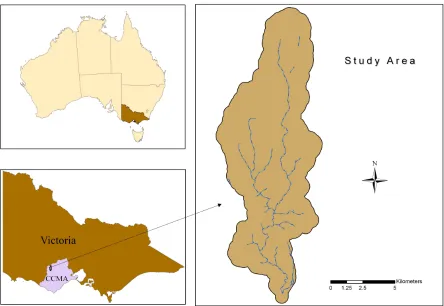
2.1. Study Area
Figure 1. Study area: terrain height varies between 303m and 139m
2.2. Data
LiDAR data for an area of 6900 km², covering most part of VVP in the CCMA region, were collected over the period of 19 July 2003 to 10 August 2003. The primary purpose of this LiDAR data collection was to facilitate more accurate terrain pattern representation for the implementation of a serious of environment related projects. The LiDAR data were delivered by AAMHatch Pty Ltd as tiles in ASCII files containing x, y, z coordinates and intensity values. The data have been classified into ground and non-ground points by using data filter algorithms across the project area. Manual checking and editing of the data led to further improvement in the quality of the classification. The resulting data products used for DEM generation are irregularly distributed ground 3D points, with an average spacing of 2.2 m. The accuracy of LiDAR data was estimated as 0.5 m vertically and 1.5 m horizontally (AAMHatch, 2003).
2.3. Methods
the accuracy of each of the range of DEMs produced.
With the IDW interpolator, a DEM was produced for each of the seven datasets. Data density, file size and processing time for generating each of these DEMs were listed in Table 1.
To assess the accuracy of DEMs generated from reduced LiDAR datasets with different data density, independent elevation checking is conducted by comparing elevation values of test data with correspondent elevation values interpolated from the DEM were calculated for each generated DEM. Root mean square errors (RMSEs) and standard deviation
σ
for each DEM were calculated to evaluate the overall accuracy of the DEM. The RMSE andσ
were calculated with:n
E
E
RMSE
=
∑
DEM−
f2
Re
)
(
(1)
σ
1
n
E
E
DEM−
−
=
∑
2
)
(
(2)
where,
E
DEMis the elevation value from the DEM, andE
Refis the correspondent reference elevation value from check points. n is the number of check points.E
is a calculated mean error with:E
=
∑
(
E
DEM−
E
Ref)
n
.Details of results are listed in Table 2.
Table1. Data density, file size and processing time for DEM generation
Reduced datasets Data density (points/per m²)
Point data file size (MB)
Processing time for DEM generation
100% 0.037 444.0 14.31 h
75% 0.028 360.0 12.31 h
50% 0.018 240.0 7.00 h
25% 0.009 120.0 3.12 h
10% 0.004 48.6 57 m
5% 0.002 24.4 27 m
[image:4.612.91.531.476.581.2]1% less than 0.001 4.92 8 m
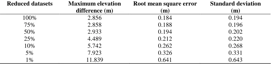
Table 2. Accuracy assessment of DEMs with different data density.
Reduced datasets Maximum elevation difference (m)
Root mean square error (m)
Standard deviation (m)
100% 2.856 0.184 0.194
75% 2.858 0.188 0.196
50% 2.933 0.194 0.202
25% 4.489 0.212 0.220
10% 5.742 0.262 0.268
5% 7.923 0.326 0.331
1% 11.839 0.641 0.643
3. RESULTS AND DISCUSSION
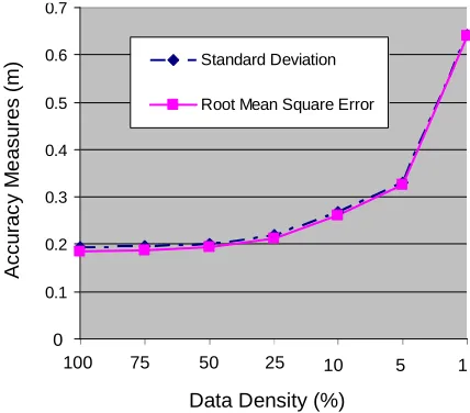
As expected, data density reduction (i.e. increased space interval between data points) influences DEM accuracy: errors increased as data density decreased (Table 2). The larger distance between sampling points adversely affects the accuracy of generated
half of the time needed for generating the DEM using the total LiDAR training dataset. It should be note that the processing time listed in Table 2 may vary with the types of computer and software to be used. Point file size is also nearly the half of the total point file size. Therefore, for this study area and LiDAR dataset, at the given resolution of 5 m, the “efficient dataset” is the one with 50% of the original data density.
100 75 50 25 10 5 1
Data Density (%)
A
c
c
u
ra
c
y
M
e
a
s
u
re
s
(
m
)
0 0.1 0.2 0.3 0.4 0.5 0.6 0.7
Standard Deviation
Root Mean Square Error
[image:5.612.87.301.196.384.2]0
Figure 2. Data reduction and DEM accuracy
This study shows that LiDAR dataset (density) reduction can increase the efficiency of DEM generation in terms of file size and processing time. However, to what extent a dataset can be reduced depends on the original data density, terrain characteristics, interpolation method for DEM generation, and target DEM resolution (grid size). In this study, the effects of LiDAR data reduction on the accuracy of DEM were evaluated for a terrain with a range of relative relief attributes. The IDW interpolation method and 5 m resolution were selected for all DEM generation. Further comparison with different interpolation methods and DEM resolution needs to be implemented if comprehensive guidelines are to be assembled.
It is inappropriate to generate a high resolution DEM with very sparse terrain data: any surface so generated is more likely to represent the shape of the specific interpolator used than that of the target terrain because interpolation artefacts will abound (Florinsky, 2002; Albani et al., 2004). The source data density constrains the resolution of DEM (Florinsky, 1998). On the other hand, generating a
low resolution DEM from high density terrain data will devalue the accuracy of the original data.
Clearly, the choice of the adequate resolution of a DEM is constrained by terrain input data density. McCullagh (1988) suggested that the number of grid cells should be roughly equivalent to the number of terrain data points in covered area. The grid size of a DEM can be estimated by:
n A
S = (3)
where n is the number of terrain points and A is the covered area (Hu, 2003). This means that the DEM resolution should match the sampling density of the original terrain points.
In this study, for the DEM with 5 m resolution, each grid has 0.75 points in average for the DEM from the 50% dataset. And so the DEM resolution roughly matches the source data density. This is one reason why the accuracy of the DEM still can be maintained while LiDAR data density could be reduced to 50% of its original data density.
The results of this study demonstrate possibilities for LiDAR data-set reduction before input to DEM generation routines. However, as mentioned, effective data reduction is affected by many factors and so further research is needed before a comprehensive set of guidelines can be assembled. It should also be noted that because not all data elements contribute optimally to the accuracy of produced DEM, the identification of feature-specific points (representing terrain features with more significant information content than other points) should be considered as an element in data volume reduction. Data reduction should be conducted in such a way that critical elements are kept while less important elements are removed (Chou et al., 1999).
4. CONCLUSION
LiDAR technology offers high accuracy and high density 3D terrain data capture for detailed representation of terrain surfaces. However, without sampling selection of high density data during input data preparation for DEM generation, the storage requirements and processing times can be inflated due to data redundancy. Terrain data-point reduction mitigates the data redundancy and improves data-processing efficiency in terms of both storage and processing time. With guided data reduction, an efficient dataset can be identified for DEM generation.
This study showed that LiDAR data can be reduced to a certain level without significantly decreasing the accuracy of the output DEM. For a moderate complex terrain, LiDAR dataset with an average spacing of 2.4 m can be reduced to 50% of its original data density without degradation of the quality of the DEM. The accuracy of DEM produced using the 50% data reduction input data has no significant difference compared with the DEM produced from total original dataset. Such data reduction can lead to significant decrease of both data file size and processing time for DEM generation without compromising the DEM quality.
5. ACKNOWLEDGEMENT
We are grateful to the Corangamite Catchment Management Authority for providing LiDAR data for this study. The comments of two anonymous reviewers are highly appreciated.
6. REFERENCES
AAMHatch (2003), Corangamite CMA airborne laser survey data documentation, AAMHatch Pty Ltd, Melbourne, Australia.
Albani, M., B. Klinkenberg, D. W. Andison and J. P. Kimmins (2004), The choice of window size in approximating topographic surfaces from digital elevation models, International Journal of Geographical Information Science, 18(6), 577-593.
Ali, T. A. (2004), On the selection of an interpolation method for creating a terrain model (TM) from LIDAR data, In: Proceedings of the American Congress on Surveying and Mapping (ACSM) Conference 2004, Nashville TN, U.S.A.
Anderson, E. S., J. A. Thompson and R. E. Austin (2005a), LiDAR density and linear interpolator effects on elevation estimates, International Journal of Remote Sensing, 26(18), 3889-3900.
Anderson, E. S., J. A. Thompson, D. A. Crouse and R. E. Austin (2005b), Horizontal resolution and data density effects on remotely sensed LIDAR-based DEM, Geoderma, 132(3-4), 406-415.
Bjørke, J. T. and S. Nilsen (2002), Efficient representation of digital terrain models: compression and spatial decorrelation techniques, Computer and Geosciences, 28, 433-445.
Blaschke, T., D. Tiede and M. Heurich (2004), 3D landscape metrics to modelling forest structure and diversity based on laser scanning data, International Archives of the Photogrammetry, Remote Sensing and Spatial Information Sciences, 36(8/W2), 129-132.
Chaplot, V., F. Darboux, H. Bourennane, S. Leguédois, N. Silvera and K. Phachomphon (2006), Accuracy of interpolation techniques for the derivation of digital elevation models in relation to landform types and data density, Geomorphology, 77(1-2), 126-141.
topographic data, Geographical Systems, 1(2), 179-197.
Desmet, P. J. J. (1997), Effects of interpolation errors on the analysis of DEMs, Earth Surface Processes and Landforms, 22(6), 563-580.
Fisher, P. F. and N. J. Tate (2006), Causes and consequences of error in digital elevation models, Progress in Physical Geography, 30(4), 467-489.
Florinsky, I. V. (1998), Combined analysis of digital terrain models and remotely sensed data in landscape investigations, Progress in Physical Geography, 22(1), 33-60.
Florinsky, I. V. (2002), Errors of signal processing in digital terrain modeling, International Journal of Geographical Information Science, 16(5), 475-501.
Gong, J., Z. Li, Q. Zhu, H. Shu and Y. Zhou (2000), Effects of various factors on the accuracy of
DEMs: an intensive experimental
investigation, Photogrammetric Engineering and Remote Sensing, 66(9), 1113-1117.
Hu, Y. (2003), Automated extraction of digital terrain models, roads and buildings using airborne LiDAR data, (PhD Thesis), Department of Geomatics Engineering, The University of Calgary, Calgary, Alberta, Canada, pp. 206.
Kidner, D. B. and D. H. Smith (2003), Advances in the data compression of digital elevation models, Computer and Geosciences, 29, 985-1002.
Kienzle, S. (2004), The effect of DEM raster resolution on first order, second order and compound terrain derivatives, Transactions in GIS, 8(1), 83-111.
Li, Z., Q. Zhu and C. Gold (2005), Digital Terrain Modeling: Principles and Methodology, CRC Press, Boca Raton, London, New York, and Washington, D.C.
Liu, X., Z. Zhang, J. Peterson and S. Chandra (2007), LiDAR-derived high quality ground control
information and DEM for image
orthorectification, GeoInformatica, 11(1), 37-53.
Lloyd, C. D. and P. M. Atkinson (2006), Deriving ground surface digital elevation models from LiDAR data with geostatistics, International Journal of Geographical Information Science, 20(5), 535-563.
Lohr, U. (1998), Digital elevation models by laser scanning, Photogrammetric Record, 16, 105-109.
McCullagh, M. J. (1988), Terrain and surface modelling systems: theory and practice, Photogrammetric Record, 12(72), 747-779.
Pradhan, B., S. Kumar, S. Mansor, A. R. Ramli and A. R. B. M. Sharif (2005), Light detection and ranging (LiDAR) data compression, KMITL Journal of Science and Technology, 5(3), 515-523.
Robinson, G. J. (1994), The accuracy of digital elevation models derived from digitised contour data, Photogrammetric Record, 14(83), 805-814.
Wehr, A. and U. Lohr (1999), Airborne laser scanning - an introduction and overview ISPRS Journal of Photogrammetry and Remote Sensing, 54(4), 68-82.
Yang, X. and T. Hodler (2000), Visual and statistical comparison of surface modeling techniques for point-based environmental data, Cartography and Geographic Information Science, 27(2), 165-175.
Yilmaz, H. M. (2007), The effect of interpolation methods in surface definition: an experimental study, Earth Surface Processes and Landforms, 32(9), 1346-1361.
Zhou, Q., X. Liu and Y. Sun (2006), Terrain complexity and uncertainties in grid-based digital terrain analysis, International Journal of Geographical Information Science, 20(10), 1137-1147.