promoting access to White Rose research papers
White Rose Research Online
[email protected]
Universities of Leeds, Sheffield and York
http://eprints.whiterose.ac.uk/
This is an author produced version of a paper published in
Advances in
Information Retrieval.
White Rose Research Online URL for this paper:
http://eprints.whiterose.ac.uk/78508
Published paper
Clough, P and Read, S (2008)
Key design issues with visualising images using
google earth.
In: Macdonald, C, Ounis, I, Plachouras, V, Ruthven, I and White,
RW, (eds.) Advances in Information Retrieval. 30th European Conference on IR
Research, 30th March - 3rd April 2008, Glasgow, UK. Springer Berlin Heidelberg ,
570 - 574.
Key Design Issues with Visualising Images using Google
Earth
Paul Clough and Simon Read
Dept. of Information Studies, University of Sheffield, UK {[email protected]}
Abstract. Using map visualisation tools and earth browsers to display images in a spatial context is integral to many photo-sharing sites and commercial image archives, yet little academic research has been conducted into the utility and functionality of such systems. In developing a prototype system to explore the use of Google Earth in the visualisation of news photos, we have elicited key design issues based on user evaluations of Panoramio and two custom-built spatio-temporal image browsing prototypes. We discuss the implications of these design issues, with particular emphasis on visualising news photos.
1 Introduction
The development of location-aware technology has increased the availability of media containing spatial and temporal information. This is particularly true for visual media such as photographs. Photo-sharing websites such as Flickr1, Pikeo2, Panoramio3 and Woophy4 now offer spatial (and temporal) image browsing facilities using generic map visualisation services such as Google Maps5, and earth browsers such as Google Earth (GE)6. The use of such interfaces is interesting, as it seems to take advantage of the mind’s inherent spatial-temporal reasoning capabilities (cf. Tversky’s concept of cognitive collages [1] and Tomaszewski et al. [2]). However, little academic research has been conducted into their utility (what such a system is useful for) and functionality (how does such a system achieve this), two key design characteristics.
To address this, we chose to evaluate the Google Earth version of Panoramio, an existing spatial image browser run on a commercial basis by Google. Our key findings were then used to develop and evaluate two prototype spatio-temporal image browsers for news photos, media that is highly time and place specific. The prototypes are being developed for a major UK-based news agency, Press Association (PA) Photos7, to investigate the use of new visualisation technologies, such as Google
Earth, within their organisation and the news photo industry in general.
2 Background
Many online image databases (such as Flickr) currently use earth browsers to enable users to browse images. Research into the display of images in a geo-spatial context can be traced back through systems such as WING [6], which combined a 3-D map with location specific text and images in a way that made it a clear predecessor of Google Earth. More recent developments have occurred in the field of Geovisual Analytics (GA), which according to MacEachren [4] is an attempt to bridge the putative gap between traditional cartography and virtual reality. Google Earth is considered to be one of the most popular platforms for GA applications [2].
3 Methodology
The research was conducted as part of a user-centered, iterative design process; providing participants with hands-on access to image browsing software. Following an initial survey of four spatial image browsing facilities (provided by Flickr, Panoramio, Pikeo, and Woophy), the first iteration consisted of an explorative user evaluation of Panoramio (arguably the most successful of the four in its use of Google Earth) to identify key issues of utility and functionality (section 4). The codified data was extracted from contemporary notes of volunteers’ behaviour and verbal feedback, together with a pre and post evaluation questionnaire completed by each volunteer. The second iteration explored these design issues by implementing two prototype systems, each displaying around 3,000 news images (from PA). The images were associated with metadata including geo-name (city and country), date, category, headline and caption. Each geo-name was manually associated with a spatial coordinate using the geonames.org online gazetteer. These two prototypes used the spatio-temporal browsing capabilities of Google Earth; the difference being that Prototype 2 also addressed the issue of clustering large numbers of spatially close images by providing single thumbnails linked to ‘galleries’ of similar (i.e. those sharing identical time, date and headline) images opened by a mouse click.
4 Results
The initial survey of image browsers identified a number of key functional design issues related to (in particular) spatial visualisation, including how to deal with many images sharing spatial proximity (clustering) and what metadata to display alongside the image. Regarding clustering, this includes whether to display an icon for each image (Panoramio), have one icon representing a set of images (Woophy) or decompose into more specific icons when viewed at a higher magnification (Pikeo). In the case of one image representing a set, this includes whether to display a 'gallery' showing further images (Flickr/Pikeo) or an "exploding cluster" (GE 4.0).
Although it became apparent that Panoramio is not an efficient means of image retrieval, several volunteers found it highly engaging and continued using it after the session. No statistically significant relationship was found between the issues of utility and functionality identified (Tables 1 and 2) and the four search tasks. Table 3 shows temporal design issues elicited from evaluation of the two prototypes.
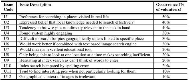
Table 1 Panoramio utility issues, by frequency
Issue Code
Issue Description Occurrence (%
of volunteers)
U1 Preference for searching in places visited in real life 50% U2 Expressed belief that local knowledge needed to search effectively 40% U3 Tendency to browse pics not directly relevant to the task in hand 40%
U4 Found system highly engaging 30%
[image:4.595.133.466.356.497.2]U5 Difficult to search for pics geographically unless linked to specific place 30% U6 Would work better if combined with text based image search engine 30% U7 Would make an excellent educational tool 20% U8 Only being able to look at one location at a time makes searching inefficient 20% U9 Hesitating at index search as can’t think of words to enter 20% U10 Index search hampered by spelling error 20% U11 Tend to find interesting pics when not particularly looking for them 10% U12 Geographical context of images is irrelevant 10%
Table 2 Panoramio functionality issues, by frequency
Issue Code
Issue Description Occurrence (%
of volunteers)
F1 Time lag before Panoramio thumbnails appear (at least 4 seconds after globe stops moving)
40%
F2 Not a big enough selection of pics available 40% F3 Zoomed in on remote area (or body of water) and no pics available 40% F4 Selected images vanish unexpectedly (due to network link updating) 30% F5 Selecting nodes because thumbnails slow to appear 30% F6 Not waiting long enough for Panoramio pics to appear before moving on 30%
F7 Delay in downloading full-size image 20%
F8 Not able to refind one or more pics previously selected 20%
F9 Not zooming in to see more images 10%
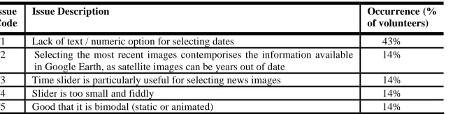
Table 3 Prototypes 1 & 2 temporal issues, by frequency
Issue Code
Issue Description Occurrence (%
of volunteers)
T1 Lack of text / numeric option for selecting dates 43% T2 Selecting the most recent images contemporises the information available
in Google Earth, as satellite images can be years out of date
14%
T3 Time slider is particularly useful for selecting news images 14%
T4 Slider is too small and fiddly 14%
T5 Good that it is bimodal (static or animated) 14%
5 Discussion
Issues of utility are important because the technology is novel. Though not necessarily a time-efficient means of image retrieval, spatio-temporal image browsing seems to hold broad appeal. One explanation is offered by Tversky’s [1] concept of cognitive collages; i.e. that spatial memory is not a single, coherent internal ‘map’ but rather a collage of diverse environmental sources (Hirtle & Sorrows [3] link this idea to WING). Combining news images and text with spatio-temporal information may be one way in which such collages could be built, thus companies like PA might use such a system to understand news images in a broader geo-spatial context, rather than simply filtering images by time and place. This corresponds with 30% of volunteers preferring a text based search to select images being viewed in GE (Table 1, U6), and 30% having difficulty searching for non location-specific images (U5).
If cognitive collages exist, then spatio-temporal display may reinforce existing collages as well as create new ones. Set in the context of PA, journalists might browse images from a familiar region to further enrich their understanding of it. A desire to reinforce existing collages could explain why 50% of volunteers gravitated towards places visited in real life (U1), 40% stated local knowledge is required for effective browsing (U2), and 40% diverted from set tasks to browse locations/images of personal interest (U3). The principle benefit that temporal image browsing adds is contemporisation (Table 3, T2), particularly useful if viewing images from a familiar (but not recently visited) place. Given that press photographers can now upload (in real time) photos embedded with GPS generated spatio-temporal information, there is strong potential for the spatio-temporal display of news images in a GA context.
(e.g. “London”). GE (release 4.0 and higher) allows such clusters to spring apart when selected, but this is ineffective for very large clusters. Prototype 2’s method of displaying one thumbnail per date/location/subject (and linking this to a ‘gallery’ containing the rest) provides a contingency; volunteers preferred this in most respects.
6 Conclusions
The increase in location-aware technologies is likely to cause more widespread use of spatial and temporal visualisation technologies. These are likely to appeal to users due to their inherent conceptual link with the mind’s spatial-temporal reasoning capabilities. Organisations like PA Photos are able to exploit such technologies for novel interfaces and new business contexts. In this paper, we have identified some of the key general design issues with using Google Earth to provide spatial and temporal search and browse. We are using these design features to guide the development of prototype systems to explore the use of Google Earth in the news photo industry. In future work, we plan to test prototypes with staff from PA Photos, perhaps using a positivist study to strengthen or discount some of the key issues suggested by this first exploratory study, and to further explore the use of spatio-temporal visualisation.
Acknowledgments
We would like to thank PA Photos for the use of photographic materials from their archive and express particular thanks to Martin Stephens and Phil Lakin. This work was partially funded by the EU-funded MultiMatch project (IST-033104).
References
[1] Tversky, B. (1993). "Cognitive Maps, Cognitive Collages, and Spatial Mental Models". Lecture Notes in Computer Science, 716, 14-24.
[2] Tomaszewski, B.M., et al. (2007). "Geovisual Analytics and Crisis Management". Proceedings of the 4th International ISCRAM Conference, May 13-16, 2007, Delft, the Netherlands. pp. 173-179. ISCRAM, Delft, the Netherlands.
[3] Hirtle, S.C. & Sorrows, M.E. (1998). "Designing a Multi-modal Tool for Locating Buildings on a College Campus". Journal of Environmental Psychology, 18 (3), 265-276. [4] MacEachren, A.M. (2001). "An evolving cognitive-semiotic approach to geographic
visualization and knowledge construction." Information Design Journal [Online], 10 (1). [5] Shneiderman, B. (1998). Designing the user interface: strategies for effective
human-computer interaction Harlow: Addison-Wesley.
[6] Masui, T., et al. (1995). "Multiple-view approach for smooth information retrieval". Proceedings of the 8th annual ACM symposium on User interface and software