ABSTRACT
HALLOWELL, GEORGE DEWEY. Understanding Structural Inertia: Examining Suburban Morphology and Patterns of Persistence and Change. (Under the direction of Dr. Perver K. Baran).
As shrinking cities in the US have moved away from the fundamental assumption that a city needs to grow and city managers begin to close sparsely populated neighborhoods, something unexpected is occurring: Remaining residents are resisting the move. Why does this inertia, or resistance to change, continue even during exceptional urban decay? This study claims that a potentially significant, yet little investigated factor in understanding the form and growth of cities is structural inertia: defined as the tendency of an urban area to resist change due to its existing physical, economic, social, and cultural fabric.
The primary purpose of this study was to understand how existing patterns of buildings, plots, blocks, and streets affect structural inertia in first-ring suburban neighborhoods. In order to understand structural inertia, measuring change or persistence in the patterns of space and the built environment over time were of primary concern. Scant research has been conducted in suburban theory, other than how suburbs begin, and the concept of
structural inertia is uncharted territory. This research develops a theoretical basis upon which practical design and policy tools can be generated to predict and design for structural inertia: particularly in the growth and decay of first-ring suburban neighborhoods.
span study of four inner-ring neighborhoods in Raleigh and Charlotte, NC. Three morphological and three space syntax independent variables were compared to the dependent variable of change—in building inventory and land use change. It was crucial that
patterns of change in the case study areas in relation to the predictor variables were measured, not merely aggregate change. Only local patterns of change over time could confirm whether the measured transformation would have occurred without the predictor variables. It was also accepted that change had to be gauged rather than persistence, it was not reliable to measure lack of change without knowing if any force for change had occurred. Analysis required generating digital maps by heads-up digitizing historic paper maps, aerial photographs, and overlaying them onto contemporary GIS data. Space syntax measures were completed inputting map data into Depthmap analysis software. Both in-case and cross case examinations were made of the relationships between the predictor and outcome variables in four separate time intervals. Change-resistant attitudes of contemporary residents were also directly measured with two well-tested psychometric place attachment scales obtained from 137 responses to 700 mailed surveys.
Understanding Structural Inertia: Examining Suburban Morphology and Patterns of Persistence and Change
by
George D. Hallowell
A dissertation submitted to the Graduate Faculty of North Carolina State University
in partial fulfillment of the requirements for the degree of
Doctor of Philosophy
Design
Raleigh, North Carolina 2013
APPROVED BY:
_______________________________ ______________________________
Dr. Perver K. Baran Professor Robin Moore
Committee Chair
________________________________ ________________________________
DEDICATION
BIOGRAPHY
ACKNOWLEDGMENTS
I would like to express my sincere thanks to my doctoral committee members, Professor Robin Abrams, Professor Robin Moore, and Professor Yan Song for their extremely valuable comments and assistance on my doctoral research and dissertation. Professor Perver Baran, my committee chair, has been extraordinarily helpful and understanding during every step of my research and preparation of the dissertation document. Her focus and encouragement toward my growth as a researcher has consumed a great deal of her time and efforts, and I am thoroughly grateful.
TABLE OF CONTENTS
LIST OF TABLES ... IX LIST OF FIGURES... XI
CHAPTER 1: INTRODUCTION... 1
1.1. INTENTION OF THE STUDY ... 2
1.2. SIGNIFICANCE AND PRIMARY GOAL OF THE RESEARCH ... 4
1.3. ORGANIZATION OF THE DISSERTATION ... 5
CHAPTER 2: LITERATURE REVIEW ... 7
2.1. FACTORS RELATED TO STRUCTURAL INERTIA ... 8
2.1.1. Political, Governmental, and Legal ... 8
2.1.2. Physical: Infrastructure and the Built Environment ...12
2.1.3. Economic ...19
2.1.4. Social/Cultural Factors: Inertia of Real and Perceived Social Fabric ...22
2.1.5. Summary: Factors Identified With Urban Structural Inertia ...25
2.2. PRECEDENTS FOR STRUCTURAL INERTIA: MODELS AND THEORIES ...26
2.2.1. An Organizational Ecology Model of Structural Inertia ...26
2.3. METHODOLOGICAL APPROACHES FOR A STUDY OF URBAN PERSISTENCE 30 2.3.1. Conzenian Morphology ...31
2.3.2. Space Syntax ...33
2.3.3. Syntheses of Space Syntax and Morphological Approaches ...47
2.3.4. Place Attachment, Place Identity, and their Measure ...51
2.4. CONCLUSION OF LITERATURE REVIEW ...55
CHAPTER 3: CONCEPTUAL FRAMEWORK AND RESEARCH QUESTIONS ...57
3.1. THEORETICAL PERSPECTIVE OF THE RESEARCH ...57
3.2. MODEL DEVELOPMENT AND CONCEPTUAL FRAMEWORK ...58
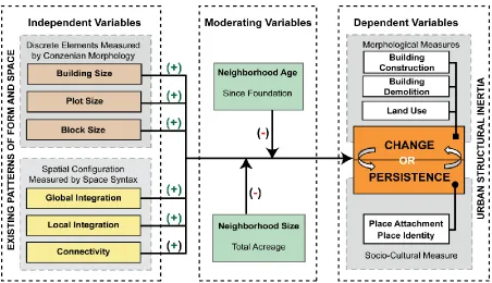
3.3. PURPOSE, SCOPE, AND PRIMARY VARIABLES OF THE RESEARCH ...64
3.4. RESEARCH QUESTIONS AND VARIABLES ...66
3.5. DEFINITION OF KEY TERMS ...67
4.1. RESEARCH STRATEGY OVERVIEW...74
4.2. DEFINING CASES AND TIME PERIODS ...76
4.2.1. Selection of Case Neighborhoods ...76
4.2.2. Database Development ...85
4.3. DATA COLLECTION METHODS ...86
4.3.1. Conzenian Morphology ...87
4.3.2. Space Syntax ...90
4.3.3. A Measurement Instrument for Place Identity and Place Attachment ...92
4.4. DATA ANALYSIS PROCEDURES ...97
4.4.1. In-Case Analysis ...99
4.4.2. Cross-Case Analysis ... 103
4.5. QUALITY STANDARDS: STRENGTHS AND LIMITATIONS ... 105
4.5.1. Construct Validity ... 105
4.5.2. Internal Validity ... 106
4.5.3. External Validity ... 107
4.5.4. Reliability ... 107
4.5.5. Study Strengths and Limitations ... 108
CHAPTER 5: FINDINGS IN INDIVIDUAL CASES ... 110
5.1. GENERAL CITY CHARACTERISTICS ... 111
5.1.1. A Brief History of Raleigh, NC ... 111
5.1.2. A Brief History of Charlotte, NC ... 113
5.2. FINDINGS: OBERLIN VILLAGE CASE STUDY NEIGHBORHOOD ... 114
5.2.1 A Brief History of Oberlin Village ... 114
5.2.2 Demographic and Socio-Economic Characteristics ... 119
5.2.3. Oberlin Village - Formal and Spatial Characteristics ... 120
5.2.4. Oberlin Village - Morphological Characteristics and Change ... 126
5.2.5. Oberlin Village – Space Syntax Characteristics and Change ... 138
5.2.6. Oberlin Village - Place Attachment and Place Identity ... 151
5.2.7 Summary of Oberlin Village Findings ... 159
5.3. FINDINGS: COLLEGE PARK/IDLEWILD CASE STUDY NEIGHBORHOOD ... 161
5.3.2. Demographic and Socio-Economic Characteristics ... 165
5.3.3. College Park - Formal and Spatial Characteristics ... 167
5.3.4. College Park - Morphological Characteristics and Change ... 173
5.3.5. College Park - Syntactic Characteristics and Change ... 178
5.3.6. College Park - Place Attachment and Place Identity ... 185
5.3.7. Summary of College Park / Idlewild Findings ... 191
5.4. FINDINGS: BIDDLEVILLE CASE STUDY NEIGHBORHOOD ... 193
5.4.1. A Brief History of Biddleville ... 193
5.4.2. Demographic and Socio-Economic Characteristics ... 197
5.4.3. Biddleville - Formal and Spatial Characteristics ... 197
5.4.4. Biddleville - Morphological Characteristics and Change ... 202
5.4.5. Biddleville - Syntactic Characteristics and Change ... 209
5.4.6. Biddleville - Place Attachment and Place Identity... 217
5.4.7. Summary of Biddleville Findings ... 224
5.5. FINDINGS: CHERRY CASE STUDY NEIGHBORHOOD ... 226
5.5.1. A Brief History of Cherry ... 226
5.5.2. Demographic and Socio-Economic Characteristics ... 229
5.5.3. Cherry - Formal and Spatial Characteristics ... 230
5.5.4. Cherry - Morphological Characteristics and Change ... 235
5.5.5. Cherry - Syntactic Characteristics and Change ... 243
5.5.6. Cherry - Place Attachment and Place Identity ... 252
5.5.7. Summary of Cherry Findings ... 259
5.6. DISCUSSION AND CONCLUSION OF IN-CASE FINDINGS ... 261
CHAPTER 6: FINDINGS: CROSS-CASE COMPARISONS ... 266
6.1. INTRODUCTION AND STRATEGY FOR CROSS-CASE ANALYSIS ... 267
6.2. COMPARING RELATIONSHIPS BETWEEN FORM AND CHANGE ... 268
6.2.1. How Do Existing Patterns of Blocks Relate to Change Over Time? ... 268
6.2.2. How Do Existing Patterns of Plot Size Relate to Change Over Time? ... 275
6.2.3. How Do Existing Patterns of Building Size Relate to Change Over Time? ... 277
6.3. COMPARISON OF RELATIONSHIPS BETWEEN SPATIAL CONFIGURATION AND CHANGE .. 278
6.3.2. How Do Patterns of Local Integration Relate to Change Over Time? ... 284
6.3.3. How Do Patterns of Connectivity Relate to Change Over Time? ... 286
6.4. COMPARISON OF RELATIONSHIPS BETWEEN CHANGE AND PLACE ATTACHMENT... 287
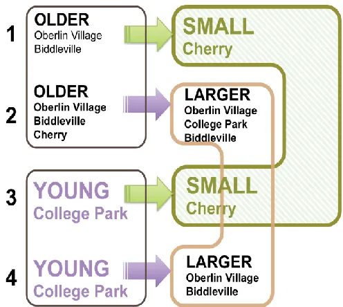
6.5. NEIGHBORHOOD AGE AS A MODERATING VARIABLE ... 294
6.5.1. How Did Findings from College Park Compare to the Other Cases? ... 296
6.5.2. Summary of Findings for Age as a Moderating Variable ... 296
6.6. NEIGHBORHOOD SIZE AS A MODERATING VARIABLE ... 297
6.6.1. How Did Findings from Cherry Compare to the Other Cases? ... 297
6.6.2. Summary of Findings for Size as a Moderating Variable ... 299
6.7. DISCUSSION AND CONCLUSION OF CROSS-CASE FINDINGS ... 300
CHAPTER 7: CONCLUSION ... 303
7.1. INTRODUCTION TO SUMMARY AND CONCLUSIONS ... 304
7.2. REVIEW OF THE CONCEPTUAL FRAMEWORK AND RESEARCH QUESTIONS ... 305
7.2.1. Research Questions ... 305
7.2.2. Research Approach ... 307
7.3. DISCUSSION AND CONCLUSIONS FROM IN CASE AND CROSS CASE FINDINGS ... 308
7.3.1. Research Question 1: Summary ... 308
7.3.2. Research Question 2: Summary ... 312
7.3.3. Research Question 3: Summary ... 318
7.3.4. Research Question 4: Summary ... 320
7.4. SUMMARY CONCLUSIONS ... 322
7.5. STRENGTHS AND LIMITATIONS OF THE STUDY ... 325
7.6. IMPLICATIONS FOR THE DESIGN COMMUNITY: HOW CAN WE USE THIS INFORMATION? 329 7.7. FUTURE RESEARCH AND GOALS ... 330
REFERENCES ... 333
APPENDICES ... 349
APPENDIX A: COMPREHENSIVE LITERATURE DIAGRAM BY TOPIC ... 350
APPENDIX B: NEIGHBORHOOD COHESION INSTRUMENT ... 351
APPENDIX C: CHART OF VARIABLES USED IN THE STUDY ... 352
APPENDIX D: TYPICAL SELF-DRAW MAP AND SURVEY INSTRUMENT ... 353
LIST OF TABLES
TABLE 4.1:SELECTED CASE STUDY NEIGHBORHOODS ...83
TABLE 4.2: RESEARCH 1:VARIABLES AND ANALYSIS TACTICS ...97
TABLE 4.3: RESEARCH QUESTION 2: VARIABLES AND ANALYSIS TACTICS ...98
TABLE 4.4: RESEARCH QUESTION 3:VARIABLES AND ANALYSIS TACTICS ...98
TABLE 4.5: RESEARCH QUESTION 4:VARIABLES AND ANALYSIS TACTICS ...98
TABLE 4.5:MATRIX FOR ANSWERING RESEARCH QUESTIONS 1A,1B,1C,2A,2B, AND 2C ... 101
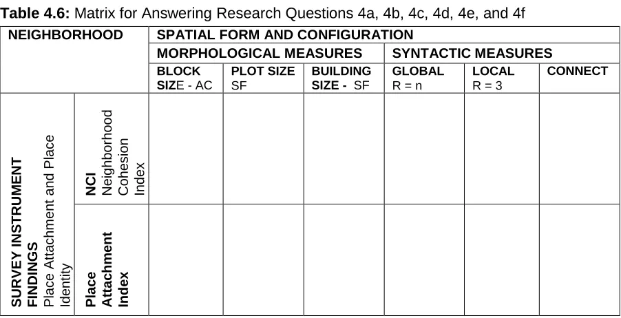
TABLE 4.6:MATRIX FOR ANSWERING RESEARCH QUESTIONS 4A,4B,4C,4D,4E, AND 4F ... 102
TABLE 5.1:OBERLIN VILLAGE –SUMMARY OF BUILDING CHARACTERISTICS ... 120
TABLE 5.2: SUMMARY STATISTICS–BLOCK,PLOT, AND BUILDING CHARACTERISTICS ... 122
TABLE 5.3: SUMMARY STATISTICS –INTEGRATION AND CONNECTIVITY CHARACTERISTICS ... 125
TABLE 5.4:DESCRIPTIVE STATISTICS FOR MORPHOLOGICAL CHARACTERISTICS ... 127
TABLE 5.5:REGRESSION RESULTS -BUILDING CHANGE BY BLOCK AND PLOT SIZE ... 133
TABLE 5.6: OBERLIN VILLAGE –BUILDING CHANGE BY INTEGRATION AND CONNECTIVITY ... 139
TABLE 5.7:REGRESSION RESULTS -BUILDING CHANGE BY INTEGRATION AND CONNECTIVITY . 142 TABLE 5.8:PEARSON CHI-SQUARE FINDINGS FOR SPACE SYNTAX MEASURES ... 151
TABLE 5.9A:CORRELATION MATRIX OF PHYSICAL PREDICTORS,NCI AND SASSCALES ... 155
TABLE 5.10:COLLEGE PARK /IDLEWILD –SUMMARY OF BUILDING CHARACTERISTICS ... 168
TABLE 5.11: SUMMARY STATISTICS –BLOCK,PLOT, AND BUILDING CHARACTERISTICS ... 170
TABLE 5.12: SUMMARY STATISTICS –INTEGRATION AND CONNECTIVITY CHARACTERISTICS ... 172
TABLE 5.13:DESCRIPTIVE STATISTICS FOR MORPHOLOGICAL CHARACTERISTICS ... 174
TABLE 5.14:REGRESSION ANALYSIS -BUILDING CHANGE BY MORPHOLOGICAL MEASURE ... 175
TABLE 5.15: COLLEGE PARK –BUILDING CHANGE BY INTEGRATION AND CONNECTIVITY ... 179
TABLE 5.16:REGRESSION ANALYSIS -BUILDING CHANGE BY SYNTACTIC MEASURE ... 180
TABLE 5.17A:COLLEGE PARK-CORRELATION MATRIX OF PHYSICAL,NCI AND SASSCALES ... 188
TABLE 5.17B:COLLEGE PARK-CORRELATION MATRIX OF SOCIAL,NCI AND SASSCALES ... 189
TABLE 5.18:BIDDLEVILLE –SUMMARY OF BUILDING CHARACTERISTICS ... 198
TABLE 5.19:SUMMARY STATISTICS OF BLOCK,PLOT, AND BUILDING CHARACTERISTICS ... 199
TABLE 5.20: SUMMARY STATISTICS –INTEGRATION AND CONNECTIVITY CHARACTERISTICS ... 200
TABLE 5.21: BIDDLEVILLE –MORPHOLOGICAL FINDINGS ... 203
TABLE 5.23: BIDDLEVILLE –SYNTACTIC FINDINGS ... 211
TABLE 5.24:REGRESSION ANALYSIS -BUILDING CHANGE BY SYNTACTIC MEASURE ... 213
TABLE 5.25A:BIDDLEVILLE-CORRELATION MATRIX OF PHYSICAL PREDICTORS,NCI AND SAS SCALES ... 221
TABLE 5.25B:BIDDLEVILLE-CORRELATION MATRIX OF SOCIAL,NCI AND SASSCALES... 221
TABLE 5.26:CHERRY:SUMMARY OF BUILDING CHARACTERISTICS ... 231
TABLE 5.27:CHERRY: SUMMARY STATISTICS –BLOCK, PLOT, AND BUILDING ... 233
TABLE 5.28:CHERRY -SUMMARY STATISTICS –SYNTACTIC CHARACTERISTICS ... 233
TABLE 5.29: CHERRY –DESCRIPTIVE STATISTICS FOR MORPHOLOGICAL CHARACTERISTICS .. 236
TABLE 5.30:CHERRY -REGRESSION ANALYSIS,BUILDING CHANGE BY MORPHOLOGICAL MEASURE ... 240
TABLE 5.31: CHERRY –BUILDING CHANGE BY INTEGRATION AND CONNECTIVITY ... 244
TABLE 5.32:REGRESSION ANALYSIS -BUILDING CHANGE BY SYNTACTIC MEASURE ... 245
TABLE 5.33A:CHERRY –CORRELATION MATRIX OF PHYSICAL PREDICTORS,NCI AND SAS SCALES ... 256
TABLE 5.33B:CHERRY –CORRELATION MATRIX OF SOCIAL PREDICTORS,NCI AND SASSCALES ... 256
TABLE 5.34:FOUR CASE STUDY NEIGHBORHOODS—IN-CASE FINDINGS OF MORPHOLOGICAL MEASURES ... 263
TABLE 5.35:FOUR CASE STUDY NEIGHBORHOODS—IN-CASE FINDINGS OF SYNTACTIC MEASURES ... 264
TABLE 6.1:MORPHOLOGICAL FINDINGS –ALL NEIGHBORHOODS,ALL TIME PERIODS ... 270
TABLE 6.2:BIVARIATE REGRESSION ANALYSIS -BUILDING CHANGE BY MORPHOLOGICAL MEASURES ... 274
TABLE 6.3:BUILDING CHANGE BY SYNTACTIC MEASURES-ALL NEIGHBORHOODS,ALL TIME .... 280
TABLE 6.4:BIVARIATE REGRESSION ANALYSIS -BUILDING CHANGE BY SYNTACTIC MEASURE . 283 TABLE 6.5:SURVEY INSTRUMENT RESPONSE DATA ... 288
TABLE:6.6:MULTIVARIATE REGRESSION MODELS -ALL NEIGHBORHOOD RESPONSES ... 292
TABLE 7.1:SUMMARY OF RESEARCH QUESTION 1-FINDINGS ... 310
TABLE 7.2:SUMMARY OF FINDINGS -RESEARCH QUESTION 2 ... 314
LIST OF FIGURES
FIGURE 2.9: LITERATURE DIAGRAM ...56
FIGURE 3.2:MATRIX OF INERTIAL FACTORS AND MODERATING VARIABLES ...63
FIGURE 3.2:CONCEPTUAL DIAGRAM ...64
FIGURE 4.4:METHODOLOGY AND DATA COLLECTION DIAGRAM ...87
FIGURE 5.1:TYPICAL CONSTRUCTION FROM EACH STUDY TIME PERIOD ... 118
FIGURE 5.3:CHARTS OF EXISTING,NEW, AND DEMOLISHED BUILDINGS BY BLOCK SIZE ... 127
FIGURE 5.4:OBERLIN VILLAGE -BLOCK SIZE AND DEMOLITION IN THREE TIME PERIODS ... 131
FIGURE 5.5:OBERLIN VILLAGE -BLOCK SIZE AND NEW CONSTRUCTION IN THREE TIMES ... 132
FIGURE 5.6: CHARTS SHOWING EXISTING,NEW, AND DEMOLISHED BUILDINGS BY PLOT SIZE . 136 FIGURE 5.7:SUMMARY CHARTS-REGRESSION COEFFICIENTS -BUILDING CHANGE BY BLOCK AND PLOT ... 137
FIGURE 5.7: CHARTS OF EXISTING,NEW, AND DEMOLISHED BUILDINGS BY GLOBAL INTEGRATION ... 141
FIGURE 5.8:OBERLIN VILLAGE -DEMOLITION AND GLOBAL INTEGRATION IN THREE TIMES ... 145
FIGURE 5.9:OBERLIN VILLAGE –LAND USE AND GLOBAL INTEGRATION IN THREE TIMES ... 146
FIGURE 5.11:CHARTS SHOWING TRENDS IN REGRESSION BETWEEN BUILDING CHANGE AND SYNTAX ... 148
FIGURE 5.12:OBERLIN VILLAGE DEMOLITION BLOCK SIZE AND GLOBAL INTEGRATION ... 149
FIGURE 5.13:NEIGHBORHOOD COHESION INDEX –SURVEY FINDINGS FOR OBERLIN VILLAGE . 153 FIGURE 5.14:STEDMAN ATTACHMENT SCALE –SURVEY FINDINGS FOR OBERLIN VILLAGE ... 154
TABLE 5.9B:OBERLIN VILLAGE-CORRELATION MATRIX -SOCIAL PREDICTORS,NCI AND SAS . 156 FIGURE 5.16:TYPICAL CONSTRUCTION FROM EACH COLLEGE PARK STUDY TIME PERIOD ... 164
FIGURE 5.18:CHARTS OF EXISTING,NEW, AND DEMOLISHED BUILDINGS BY BLOCK SIZE ... 174
FIGURE 5.19:COLLEGE PARK–MAPS OF BLOCK SIZE AND DEMOLITION IN THREE TIMES ... 177
FIGURE 5.20:COLLEGE PARKGLOBAL INTEGRATION BY EXISTING,NEW, AND DEMOLISHED... 179
FIGURE 5.22: DETAIL OF COLLEGE PARK IN 1980 OF GLOBAL INTEGRATION AND DEMOLITION 182 FIGURE 5.23: COLLEGE PARK -INTEGRATION BY EXISTING,NEW, AND DEMOLISHED BUILDINGS ... 183
FIGURE 5.24: SURVEY RESULTS FOR COLLEGE PARK NEIGHBORHOOD COHESION INDEX ... 187
FIGURE 5.27:TYPICAL CONSTRUCTION FROM EACH BIDDLEVILLE STUDY TIME PERIOD ... 196
FIGURE 5.29:BIDDLEVILLE -EXISTING,NEW, AND DEMOLISHED BUILDINGS BY BLOCK SIZE .... 203
FIGURE 5.30: BIDDLEVILLE –BUILDING DEMOLITION AND BLOCK SIZE -THREE TIME PERIODS 205 FIGURE 5.31:CHARTS OF EXISTING,NEW, AND DEMOLISHED BUILDINGS BY PLOT SIZE ... 208
FIGURE 5.32: CHARTS OF EXISTING,NEW, AND DEMOLISHED BUILDINGS BY INTEGRATION ... 211
FIGURE 5.33:BIDDLEVILLE–DEMOLITION AND GLOBAL INTEGRATION IN THREE TIME PERIODS 212 FIGURE 5.35:BIDDLEVILLE:GLOBAL INTEGRATION,BLOCK SIZE,DEMOLITION -THREE TIMES . 214 FIGURE 5.34:BIDDLEVILLE –LAND USE AND GLOBAL INTEGRATION IN THREE TIME PERIODS .. 216
FIGURE 5.36:SURVEY RESULTS FOR BIDDLEVILLE –NEIGHBORHOOD COHESION INDEX ... 218
FIGURE 5.37:SURVEY RESULTS FOR BIDDLEVILLE –STEDMAN ATTACHMENT SCALE (SAS) .... 219
FIGURE 5.39:TYPICAL CONSTRUCTION FROM EACH CHERRY STUDY TIME PERIOD ... 229
FIGURE 5.41:CHARTS COMPARING BLOCK SIZE TO EXISTING,NEW,DEMOLISHED BUILDINGS 236 FIGURE 5.42:CHERRY -DEMOLITION AND BLOCK SIZE IN THREE TIME PERIODS ... 238
FIGURE 5.43:CHARTS COMPARING BLOCK SIZE TO EXISTING,NEW, AND DEMOLISHED BUILDINGS ... 242
FIGURE 5.44:EXISTING,NEW, AND DEMOLISHED BUILDINGS BY GLOBAL INTEGRATION ... 244
FIGURE 5.45:CHERRY -DEMOLITION AND GLOBAL INTEGRATION IN THREE TIME PERIODS ... 247
FIGURE 5.46:CHERRY -NEW CONSTRUCTION AND GLOBAL INTEGRATION IN THREE TIMES ... 248
FIGURE 5.47:CHERRY –LAND USE AND GLOBAL INTEGRATION IN THREE TIME PERIODS ... 249
FIGURE 5.48:CHARTS OF TRENDS IN REGRESSION BETWEEN BUILDING CHANGE AND SYNTAX ... 251
FIGURE 5.49:SURVEY RESULTS FOR CHERRY -NCISCALE ... 254
FIGURE 5.50:STEDMAN ATTACHMENT SCALE –SURVEY FINDINGS FOR OBERLIN VILLAGE ... 255
FIGURE 6.1: CHART OF BUILDING CHANGE BY BLOCK SIZE IN ALL TIME PERIODS ... 272
FIGURE 6.2:ALL NEIGHBORHOODS-DEMOLITION IN ALL TIME PERIODS WITH 2010BLOCK SIZE ... 273
FIGURE 6.3: CHART OF BUILDING CHANGE BY GLOBAL INTEGRATION –ALL TIME ... 281
FIGURE 6.4:ALL NEIGHBORHOODS–DEMOLITION ALL TIME,GLOBAL INTEGRATION 2010 ... 285
FIGURE 6.5:SURVEY RESULTS -ALL FOUR NEIGHBORHOODS -NCISCALE ... 289
FIGURE 6.6:SURVEY RESULTS FOR ALL FOUR NEIGHBORHOODS –SASSCALE ... 291
CHAPTER 1: INTRODUCTION
including economic cataclysm, natural disaster, war, and terrorism (Campanella & Vale, 2005; Campanella, 2006; Newman, Beatley, & Boyer, 2009; Sarkis, 2009). Campanella and Vale (2005, p. 345) include as one of their axioms of resilience: “the resilience benefits from
the inertia of prior investment.” Certainly the vast investment in built form and infrastructure that Campanella and Vale describe provides an inertial resistance to change, however, a careful examination of recent urban literature suggests that prior investment is merely one component of an active and powerful force at work in the resilience and persistence of cities:
structural inertia.
1.1. INTENTION OF THE STUDY
This study claims that a potentially significant, yet little investigated factor in understanding the form and growth of cities is structural inertia: which I have defined as the tendency of an urban area to resist change due to its existing physical, economic, social, and cultural fabric. The immense investment in built form and human resources in the existing urban environment fundamentally resists change. In the early 1970s, the geographer Richard Morrill (1970, p. 6) argued: “undoubtedly the greatest influence on the future location of people and activities is their present location. Most human locational decisions depend so much on previous experience that existing patterns are strongly reinforced.” Further, the
housing in Detroit has fallen below the replacement value of the structure, and jobs and socio-cultural amenities have essentially vanished, people still live in the houses (Glaeser & Shapiro, 2003; Glaeser & Gyourko, 2005). While it is clear that the intrinsic dollar value of residential and commercial structures is one ingredient in structural inertia, the decimated communities of Detroit and Flint also resist the downward spiral of economic decline and change with a well-developed pattern of utility and road infrastructure, mature social patterns, imageable neighborhoods with clear senses of place, and a rich heritage of cultural and ethnic identity. Transportation patterns (Warner, 1962), property lines, and existing homes and factory buildings—even if unsuited for new uses—also seem to exert inertia on urban spatial patterns directly proportional to the cost of altering or replacing that infrastructure. The cultural memories and images of a neighborhood—if strong enough— appear to resist many forms of change or development, even if that neighborhood has decayed beyond self-sufficiency. Tax code decisions, locations for new public housing, building codes, and zoning ordinances affect—and are affected by—the structural inertia of reproducibility. Often inexplicably, that tendency to repeat what has been done before remains unaltered, even if that pattern is demonstrably ineffective.
A larger question remains however. If all of these factors exhibit a strong resistance to change inherent in the socio-economic and formal structure of our suburbs: How does this process work? How do these factors interact to enhance or modify persistence and resilience? Even though city planners and designers intuit the existence of these inertial factors in the growth and change of communities, how can they design for either change or
1.2. SIGNIFICANCE AND PRIMARY GOAL OF THE RESEARCH
McManus and Ethington (2007, p. 318) assert that although the origins, compositions, and periodicities of America’s suburbs have been well researched, little effort has been exerted to understand the process of change within suburban neighborhoods over time. “With very
few exceptions, the field of suburban studies has ignored the question of what happens to a suburban seedbed after it has been planted: after it ceases to occupy the leading edge of a metropolis, once it no longer stands as the historically typical suburban form” (McManus & Ethington, 2007, p. 319). Taking up the gauntlet of their challenge, this study aims to shift the focus from suburbs at the point of their initial founding on the periphery, to a comprehensive longitudinal study of their ongoing metamorphosis and resistance to change, long after they have matured and been absorbed into their larger metropolitan regions.
upon which practical design and policy tools can later be generated in the pursuit of a more comprehensive understanding of structural inertia.
The overarching practical goal of this study is to produce a viable structural inertia model as a primary step in the future development of a new set of tools to understand and predict the persistence of economically or physically devastated neighborhoods; as well as the normal urban growth patterns that we see around us every day. Without an understanding of the forces of structural inertia at work in a declining city such as Detroit, how can urban planners, architects, and policy-makers understand why a city persists even though 90% of its housing stock has fallen below the cost of building anew? Knowledge of structural inertia could enable urban designers to better stabilize and strengthen affected neighborhoods, rather than potentially working against existing patterns and forces. Architects and planners would be able to successfully revitalize older suburbs in preference to unsustainably leap-frogging to new greenfield developments. Designing in concert with the forces of structural inertia, however, requires an understanding of the variables and processes that drive and sustain this apparently active and powerful resistance to change. Finally, this research is directed toward a relatively unexplored segment of older North American cities, first-ring suburbs. Puentes and Warren (2006, p. 1) contend that a vital change in urban policy has been a recent focus on inner-ring neighborhoods. “Home to nearly 20 percent of the US population, first suburbs are, and have always been important.”
1.3. ORGANIZATION OF THE DISSERTATION
CHAPTER 2: LITERATURE REVIEW
inertia. Finally, this chapter will investigate the theories and research methodologies of Conzenian morphology, space syntax, and psychological measures of spatial identity, while delving into studies that have employed these approaches separately or in combination toward a research approach and understanding of urban and suburban morphogenesis.
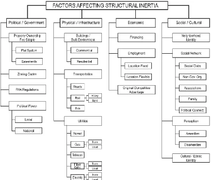
2.1. FACTORS RELATED TO STRUCTURAL INERTIA
The following four factor categories related to urban and suburban structural inertia are derived from research literature emanating from a wide range of fields. The literature implicating these factors also relates to issues over an extensive spectrum of geographic scales, from a single building to an entire metropolitan region.
2.1.1. Political, Governmental, and Legal
subdivided. “The original gridiron which drew the line between public and private territories not only dominated patterns of change, but also remains as an indelible footprint of city form.” In fact, Moudon (1986, p. 134) contends: “the single most powerful determinant of urban architecture is the ownership structure of the land.” Clearly urban designers, planners, and historians have recognized the critical importance and permanence of the initial layout and tenure of land ownership and rights-of-way within suburban neighborhoods; however, sparse theory exists to explain the relationship between morphogenesis and the initial division of land and its ownership.
Five years after the destructive fury of hurricane Katrina, areas of New Orleans, such as the Lower Ninth Ward, remain decimated and barren in places; yet the otherwise hidden power of plot lines, street rights-of-way, and infrastructure are still obvious. Figure 2.1 shows clear Figure 2.1: The Manifestation of Property Lines in New Orleans After Katrina
spatial demarcations of property lines made manifest by the mere maintenance of vegetation and fragments of built infrastructure such as sidewalks and utility lines. Breunlin and Regis (2006, p. 745) note that since Katrina, many residents have used the power of property ownership to contest forced displacement. Raynard Casimier Sr., a New Orleans pastor and property owner, is quoted in the local paper as saying, “Somebody wants our dirt. Disaster is big money. I want to see my people come back for their dirt” (Breunlin & Regis, 2006, p. 745). The ownership of land has at times formed the legal basis for citizenship rights, and still serves to anchor a cultural citizenship in the US. Although the contributions to structural inertia by sense of place and social infrastructure shall be further investigated in section 2.1.4, there is clearly a broad range of inertial factors involved with property ownership and other equally potent associations with the land. In fact, proprietary rights are assumed without hesitation even in situations where legal property ownership is uncertain, and a specific social or ethnic group inhabits a local community playground or other territory (Fried, 2000, p.193). Indeed, many societies maintain a strong identity between place and people. “This social image is the primeval core of territorial identity…a latent assumption that people belong to the land” (Fried, 2000, p.194).
condition of diminutive city blocks has also influenced other inertial factors in the morphogenesis of Savannah, including: “a continuously built street edge, which in turn, provides the opportunity for an active exchange between public and private space.” Anderson clearly indicates a relationship between the original pattern of small blocks and a resulting mosaic of socio-cultural activity and street edge condition, but why does the historic initial morphology result in these later patterns of activity—what mechanism takes place that results in the current configure of socio-cultural and physical conditions?
2.1.2. Physical: Infrastructure and the Built Environment
urban form would be to make blocks smaller: “Most blocks must be short; that is, streets and opportunities to turn corners must be frequent” (Jacobs, 1992, p. 150). Clearly Jacobs’ recommendation is focused on the economic and cultural success of a neighborhood, but what is the implication for block size vis-à-vis resistance to change, and how might this relationship differ in suburbs? Although studies have looked at various rates of change over time to street and block configurations due to block size, considerably less research has examined the relationship between the initial street/block patterns and the relative persistence of land use, building longevity, and property ownership within urban blocks.
of changing the environment.” In other words: as lots decline in size, structural inertia increases, ceteris paribus.
and Ferdelman’s study did not go through this same cycle of obsolescence and demolition. Structures on these streets were five times more likely to survive (p. 23). Of the buildings in the study area, the most likely to change—demonstrating the least structural inertia—were
the very smallest buildings at less than 700 S.F., and the second most likely to change were the larger buildings. Standard single or double row houses with commercial use on the first floor were the most structurally inert. Scheer and Ferdelman (2001, p. 25) note that the larger non-residential buildings were less flexible than the standard row house, and were more expensive to renovate: for this reason, they were more susceptible to the forces of change, and many did not survive. Ryan (2011) has also established an intriguing and significant difference in persistence within historic patterns of both plot and building form in Philadelphia and Detroit. His research indicates that even the construction materials
predominately used in neighborhood homes seems to significantly affect the structural inertia in the community. The lightweight materials typically employed in older Detroit and New Orleans homes were relatively ephemeral—deteriorating or burning with comparative ease. However, in cities that were more typically brick or stone rowhouses, like Philadelphia or Baltimore, older neighborhoods displayed remarkable persistence—even in abandoned rowhouse blocks.
utilities indicated in these studies, it is startling to observe that the original planning and layouts of today’s new suburban communities are very often relegated to private developers and contractors with little oversight by city planning departments. However, even if policy makers and city designers were willing and able to control more of the initial suburban street layouts, utility rights-of-way, street standards, and patterns of property ownership: future growth, endurance and success of these neighborhoods would be no more predictable than those privately developed without a more comprehensive understanding and workable model of the underlying forces of structural inertia.
community:” perhaps indicating that even the perception of efficiently spent public funds may increase structural inertia.
2.1.3. Economic
correspondence between the number of homes in a city and the number of people in that city. It takes decades, if not centuries, for the housing in cities to disappear, and while the houses remain, the cities remain, attracting residents with homes that cost a fraction of new construction costs” (Glaeser & Gyourko, 2005, p. 3; Glaeser, 2008). While the notion of housing-as-infrastructure is a nascent development in the field of economics, it is almost non-existent in the study of persistence and change in urban design and planning studies. How does this seemingly powerful factor in suburban morphogenesis fit into a larger model of change? What are the ramifications of housing persistence on agglomeration modeling?
neighborhood. Many of the socio-economic studies and models produced during the 1950s through the 1980s that focused on aggregate differentials of suburbs and cities, reinforced notions that individuals with higher social and economic status deserted inner cities for suburbs—and certainly in the aggregate, this Burgess (1925, pp. 47-62) model of city growth had empirical support. However, researchers that began to look at change in
individual neighborhoods uncovered a substantially different pattern of change and persistence in suburban areas. As early as the 1960s, researchers began to discover that when individual suburban growth and change patterns were examined, particular suburbs retained their unique socio-economic characteristics for long periods of time, even during periods of rapid population growth. “Yet as individual entities, suburbs demonstrate a stability of characteristics relatively little affected by population growth. This suggests that the characteristics of a suburb may be fixed relatively early in that suburb's history and subsequent growth reinforces existing socioeconomic residential patterns” (Farley, 1964, p. 40). Later studies continued to reinforce, detail, and expanded this persistence model (Collver & Semyonov, 1979; Stahura, 1979), yet the central trend of research into suburban change has continued to follow the aggregate patterns of change rather than the persistence of the individual suburb. This lack of attention to the individual neighborhood characteristics of change and persistence—especially longitudinally—would seem to indicate a need for further research.
interviews of displacement survivors: “I realized the loss he was describing was, in a crucial way, the collective loss. It was the loss of a massive web of connections—a way of being— that had been destroyed by urban renewal; it was as if thousands of people, who seemed to be with me in sunlight, were at some deeper level of their being wandering lost in a dense fog, unable to find one another for the rest of their lives. It was a chorus of voices that rose in my head, with the cry, ‘We have lost one another’” (Fullilove, 2004, p. 4). What Fullilove describes as a “massive web of connections,” this “way of being,” is a succinct introduction to the next category of inertial factors: the psychological, social and cultural fabric of society.
unambiguous: ‘I felt as though I had lost everything’” (Fried 1963, p.151). Spatial identity designates the geographic or physical dimension within which “houses, streets, even whole communities can bound, intensify, and provide a spatial locus for identification and community attachment linked to social group identity” (Fried, 2000, p.197). Fried (1963, p.156; 2000; Fullilove, 1996, p. 1520) postulated: “We might say that a sense of spatial identity is fundamental to human functioning. It is based on spatial memory, spatial imagery, the spatial framework of current activity, and the implicit special components of ideals and aspirations.” Fried (1963, p. 168) concluded that identification with community and dislocation-loss emerged from a dual sense of identity: spatial and group identities. Spatial identity is based on important spatial experiences and memories concerning environmental arrangements and contacts in relation to “a person’s conception of her own body in space” (p. 156). Of equal importance is the individual’s dependence on a sense of group identity based on stable, social networks and the external availability and overt contact with familiar groups of people. At the extreme end of place attachment, psychological and social bonds can even become dysfunctional, when the desire to cleave to the fragments of a home that has been physically or socio-culturally destroyed—even against all possibility of living there again (Fullilove, 1996). Resistance to change in a place that is so extreme that it has become indelibly attached to the psyche is certainly a force of structural inertia. Although the power of identity and attachment appear undeniable through decades of environmental research: how these constructs fit within the processes of neighborhood change and persistence are less clear—and certainly worth further study.
self-identity, including: spatial identity, place identity, place attachment, and life course (Fried, 2000, p.197; Giuliani, 2003; Proshansky, et al., 1983; Relph, 1976; Robert, et al., 2010). A more comprehensive review of place identity and place attachment is presented in section 2.3.4 toward a methodology for measuring the relationship between these socio-cultural and psychological constructs and structural inertia in suburban neighborhoods.
2.1.5. Summary: Factors Identified With Urban Structural Inertia
2.2. PRECEDENTS FOR STRUCTURAL INERTIA: MODELS AND THEORIES
2.2.1. An Organizational Ecology Model of Structural Inertia
In the early 1980s, Michael Hannan and John Freeman (1984) introduced the notion of
structural inertia to the field of organizational ecology to help explain the forces of change and persistence in the dynamics of large corporations. Hannan and Freeman argued that prior to that time, theories of change in large organizations had been modeled on a
urban neighborhoods, Hannan and Freeman realized that inertial pressures on existing organizations are high, but that structural inertia is a consequence of a selection process rather than a chosen and desirable precondition for selection. The authors also proposed that inertial forces vary with the age, size, and complexity of an organization.
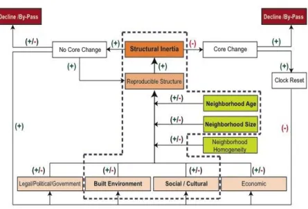
Hannan and Freeman argued that the relationship between the factors of structural inertia could not be considered statically. In the development of a suburban model of structural inertia, it is assumed a priori that urban processes should be considered dynamically. To
claim that urban morphology is subject to strong inertial forces is not the same as claiming that urban fabric does not change. Rather, it means that suburban neighborhoods respond relatively slowly to the occurrence of threats and opportunities in the environment. Therefore structural inertia must be defined in both relative and dynamic terms (Hannan & Freeman, 1984, p. 151). It is also helpful to remember James Vance’s (1990, p.6) observation that the study of urban processes poses “a real problem: how can a continuous
force be captured for observation and analysis? We may start with rather scant, or gross, phenomena, leading to a statement of basic process relationships, and hope as more information is made available to refine that statement.”
With an understanding of how the Hannan and Freeman model applies to the persistence of large organizations of people: what processes or components might be applicable to an
urban model of structural inertia? If the evolutionary process of an urban community is
moderated by the homogeneity of the forms, spaces, and socio-economic characteristics of its residents. These analogous components and processes in the Hannan and Freeman model will be examined in an urban model of structural inertia in Section 3.2.
2.3. METHODOLOGICAL APPROACHES FOR THE STUDY OF URBAN PERSISTENCE
This section of the literature review explores three methodological approaches that appear useful for studying patterns of urban morphogenesis and the underlying processes of change and persistence in urban settlements. Prior to the advent of two of these approaches—Conzenian morphology and space syntax—research into the relationship
2.3.1. Conzenian Morphology
Scheer (2004, p. 106) notes that the study of urban and suburban morphology is the study of the form of cities over time. Morphologists analyze a city’s evolution from its inception through all of its subsequent transmutations: identifying, categorizing, and dissecting its manifold components (Moudon, 1997, p. 3). Because the city is an accretion and synthesis of incalculable numbers of decisions made as individual and group actions at every moment of every day: urban morphologists focus instead on the tangible culminations of these socio-economic and cultural forces at play, rather than the decisions themselves. They study “the outcomes of ideas and intentions as they take shape on the ground and mould [sic] our cities” (1997, p.3). In a broad sense, there are three schools of thought in the field of urban morphology that involve architects, geographers, historians and planners studying form, space and change in cities. Two of these schools center on the works of prominent early figures in the field. M.R.G. Conzen, a geographer transplanted to England from Germany founded the core of the British School beginning with his detailed study of Alnwick (Conzen, 1960). Muratori (1963) developed operational histories of Venice and Rome as a theoretical basis for his architectural design studios using his own inductive and inductive reasoning process. The French School was centered on work at the architecture school at Versailles at the dissolution of the Beaux-Arts movement (Moudon, 1997). This study follows the general process of Conzen and the British School, including the teachings of M.R.G. Conzen and later researchers such as J.W.R. Whitehand (1977), K. Kropf (2009), and P. Larkham (2006). At its most basic level, the Conzenian school of urban morphology looks at
to the city or region of the country, and are commonly related to concurrent cycles in the economy, or the rhythm of change in the structure of society and culture. Morphological theory also tends to focus on what Conzen referred to as the ‘plan unit’, or what Muratori and the Italian school of morphology term ‘tissue’—tessuto. These tissues are groups of buildings, open spaces, lots, streets, and blocks that form a cohesive fabric because of some defining characteristic, such as: the year they were built or a common process of transformation.
2.3.2. Space Syntax
Thirty years ago, Hanson and Hillier (1982, pp. 5-25) looked at Georgian and Edwardian period London row houses to understand the significant differences in appearance and use between renovated and non-renovated units. Traditionally, investigators of domestic spatial morphology had assumed that internal plan organization was purely functional, and the layered hierarchy between the interior and the street was primarily concerned with privacy and security similar to the defensible space hierarchy posited by Newman, Alexander and others (Newman, 1996; Alexander, Ishikawa, & Silverstein, 1977, pp. 375-396). Yet, these theories “completely failed to account for the findings of ethnographic studies of domestic space organisation [sic].” To their surprise, Hillier and Hanson (1982, p.6) found that in society, space “features a means of social and cultural identification.” It became clear that “there are broad principles underlying the set of manifest spatial behaviors, the origins of which are not to be sought in basic human needs, but rather in the ways in which space encodes and transmits social meaning” (Hillier and Hanson, 1982, p.6). Through this early study and those to follow, Hillier and his colleagues demonstrated in the basic theory of
different route. These two concepts underlie much of the theory of space syntax, but depth
will be used in a more developed and quantitative form: which is termed integration. The
integration value of a space articulates the relative depth of that space from all other spaces in the graph.
Here, in their early thesis, is the basic premise of structuralism—that all human cultural and
social behavior has an underlying structure that is unobservable. Eight years before, Hillier & Leaman (1974) suggested that understanding spatial configuration requires an appreciation of how the “internal autonomic structure of the simplest structures of the morphology already contain the rules which govern aggregation into higher logical forms” (Hillier & Leaman, 1974, p. 6). Epistemologically, Hillier and Hanson did not assume an objective understanding of the world, but rather, a subjective perception of a set of arbitrary built artifacts that were given social and cultural meaning by a non-manifest elemental structure that was encoded in the formation of space itself. Hillier and Hanson accepted that
C
C
C B
B B
A C
B
A A
C B
A
(i) (ii) (iii)
what was directly perceivable was merely a set of arbitrary built artifacts and that knowledge of social and cultural reality was in the interrelationships between these spatial artifacts. Hillier and Hanson were working within the well-established tenets of structuralism developed in the late 1920s by the Swiss linguist Saussure, and later works by the anthropologist Levi-Strauss. Levi-Strauss postulated that culture is like language, in that it is a “collection of arbitrary symbols”—like phonemes—that follows a hidden system of interrelated rules and patterns (McGee, 2000, p.330). In the same way that the Saussure had found an atomistic unit in linguistics, Levi-Strauss wanted to uncover a basic and indivisible unit that could be used in the study of anthropology—a set of arbitrary symbols that would allow an understanding of culture. He was not concerned with the set of symbols themselves, but rather the patterning of the elements/symbols, and the way that these cultural elements relate to one another to form the overall system (Levi-Strauss, 1963, p.208).
and interpretation of spatial configuration in buildings and settlements.” They further define
configuration as, at least, the relation between two spaces taking into account a third, and at most, “the relations among spaces in a complex taking into account all other spaces in the complex.” Hillier and his colleagues realized that human societies use space as a critical and essential resource in organizing themselves. “In doing so, the space of habitation is configured; a term that space syntax recognized as an act of turning the continuous space into a connected set of discrete units” (Bafna, 2003, p. 17). In configuring space into discreet units, the experience of a building or settlement is defined. More than this, spatial configuration both carries critical social and cultural information, and is also itself manipulated by society and culture—each domain modifies the other. Socially and culturally, space is never a mere neutral background of our physical existence. The configuration of space is an essential aspect of how cultures and societies are made manifest in the objective reality of the world. As Hillier (2007, p. 20) contends: “Human behavior does not simply happen in space. It has its own spatial forms. Encountering, congregating, avoiding, interacting, dwelling, teaching, eating, conferring are not just activities that happen in space. In themselves they constitute spatial patterns.” It is also clear that these spatial patterns—just as with the hidden system of interrelated rules and patterns that occur in language—are not the attributes of individuals, but are the patterns, or
configurations, of groups of people. Hillier and Hanson began to see a schism that was occurring in research of the early 1980s between spatial structure and social formations. Hillier saw this lack of model theory that looked at both realms as “the problem of space.”
1984, p. 26). In their view, the lack of theory involving both social logic and spatial structure was due to the de-socializing of space and the de-spatializing of society. Hillier contended: “Society can only have lawful relations to space if society already possesses its own intrinsic spatial dimension; and likewise space can only be lawfully related to society if it can carry those social dimensions in its very form” (Hillier & Hanson, 1984).
Space Syntax: Movement and the City
Hillier, Hanson, and their colleagues at the University College London, have continued to develop space syntax research into a reliable and comprehensive theoretical and methodological approach. Although the theory of spatial configuration and social structure in space syntax is an efficacious approach for a range of scales from the interior of a building to the spatial and social patterns of a city or region, the basic principals and methodologies are somewhat different between building interiors and urban scale spaces. At any scale, though, Hillier (1996, p. 153) notes that form and function in space are not independent. At a very basic level, Hillier observed that there is a natural geometry to what people do in space. “People move in lines, and tend to approximate lines in more complex routes. Then if an individual stops to talk to a group of people, the group will collectively define a space in which all the people the first person can see can see each other” (p.153). Hillier (1996, p. 153) contends that the fundamental correlate of the spatial configuration of cities and suburbs is movement. In fact, a foundational tenet of space syntax is that the configuring of space in cities provides the material preconditions for patterns of movement, encounter, and avoidance (Osmond, 2010, p.14; Hillier & Hanson, 1984).
and through those spaces. The notion of an urban movement economy says that if a city is considered as a complex that carries movement from every space to every other space inside the system, than certain linear spaces that are most directly connected to every other space will have a tendency to attract higher densities of through-movement—they will be most integrated into the system as a whole.
Peponis & Wineman (2002, p.271) note that this foundational theorem has three corollaries. (1) First, the form and distribution of movement in cities and buildings is a direct function of spatial configuration (Hillier, Penn, Hanson, Grajewski, & Xu, 1993). Social logic arises from the spatial configuration itself—space has a generative function such that extraneous social rules or norms do not have to be applied in order to account for the distribution of movement. (2) Second, patterns of co-awareness and co-presence that emerge as a consequence of movement present a form of virtual community—such as restaurants and bars taking advantage of areas of greater exposure to “liveliness.” (3) Third, the movement theorem establishes an analytical approach to spatial systems as economies, with the ability
A B A
B
CONVEX SPACE CONCAVE SPACE
to distinguish space uses according to their attraction or repulsion from movement densities—such as retail uses demanding the closest connection to concentrated movement patterns.
It is of critical importance to understand that space syntax analysis considers the topological relationships of spatial configuration, rather than mere metric data, and allows rigorous and quantifiable examinations of both cities and building interiors that are both theoretically based, and mathematically repeatable. The first important topological aspect of urban spatial structure is the one-dimensional straight line or axis. The second critical aspect is the two-dimensional convex space. Convexity in mathematical terms is the notion that any straight line constructed within a certain space will stay within the space. For example (see Figure 2.5), a space with a corner that intrudes into the space would be concave rather than convex because it would be possible to inscribe a straight line that leaves the boundary of the space. The map of convex urban spaces presented in Figure 2.6 illustrates the “fattest” convex spaces—based on their area/perimeter ratio—of non-overlapping convex areas in the plan of a town. The connections between each convex space and the next are the permeable thresholds—gaps that allow movement from one space to another.
importance of the axial line map is based on two major assumptions: the importance of line-of-sight as an intelligibility and way-finding device, and that the number of turns on a path are more important to human spatial experience than actual metric distance covered.
The ultimate goal in the generation of the axial and convex space maps is an abstracted graph of the axial map because the target of the investigation is the topology of configured spaces rather than their manifest geometries. The derived axial graph represents—contrary to intuition—lines of the axial map as nodes and the intersections of lines as edges. From this relatively straightforward construct, a wide variety of metrics for the study of configured space (Hillier & Hanson, 1984) have been generated, including: Connectivity—which is the
measure of how many other nodes are connected to each node; Global Integration—which
Local integration—which is the measure of how well each node is connected to all other
nodes within a certain number of steps or radius, most commonly as radius=3; and
Intelligibility—which is the measure of the correlation between connectivity and global
integration values for each node in the system, giving a notion of the global nature of an environment through its local properties.
not merely as a background for human activity, but rather as an intrinsic aspect of everything human beings do (Hillier & Vaughan, 2007, p.3): it forms, and is formed by, human activity and culture. As people move though space, interact with other people in space, or just see ambient space from a single point, all these activities have a natural and necessary spatial geometry: movement is linear, interaction requires a convex space, and any point in space can see a visual field referred to as an isovist (Benedikt, 1979). Each of these three geometric notions describes some aspect of how we experience space. For example, urban space is for the most part linear—streets, boulevards, and roads: with occasional convex spaces, such as squares or plazas. The second core idea in space syntax is that human space is not merely about individual spaces, but rather the interrelations between the many spaces that form part of the morphology of a city or suburb (Hillier & Vaughan, 2007, p.3): referred to as the configuration of space. The reason that the configuration of space is important—the means by which space acquires social meaning and has social consequences—is that spatial configuration is different when seen from different points of view in the layout of the city. In Figure 2.4 we saw a spatial configuration within an enclosure—a building, and the resulting justified graphs of the layout based on different available paths. The shapes of the two justified graphs then culminate in a measure of integration-segregation. The pattern of the graph shows the degree to which one must pass though other spaces to go from a particular location—space—to all other locations—spaces. The graph of (ii) is shallower than (iii), and is therefore said to be more
Although there are a number of metrics that can be used to describe the configurational properties of an urban grid, Hillier and others (Hillier, Penn, Hanson, Grajewski & Xu, 1993, p. 35; Hillier & Vaughan, 2007, p.4) note that by empirical evidence, by far the most important measure is termed ‘integration radius n’—also known as ‘global integration’. Global integration measures the mean depth from each line or space to every other line or space in the system: “relitavised with respect to how deep they could possibly be with that number of spaces” (Hillier & Vaughan, 2007, p. 18). The most integrated spaces within the layout—those from which all other spaces are shallowest, and the most segregated spaces are those from which all other spaces are deepest. Another important measure, called ‘integration radius 3’—also referred to as ‘local integration’, measures the mean depth of all other spaces up to three steps away from each space in turn. From a mathematical perspective, the integration metric is also known as closeness (Hillier & Hanson, 1984, pp. 108-114). For an illustrated example of deriving measures of integration and segregation of an axial map through the use of justified graphs, refer to Figure 2.8.
Beyond these simple axioms, space syntax is also able to examine spatial and social correlates such as: depth/integration, co-awareness, co-presence, inhabitants versus visitors, symmetry, distributedness, convexity, and the dynamic nature of the spatial structure. Combining global integration and the local measure of connectivity, the
• Space Syntax: Technique and Measurement
Stepping back to the foundational theory in The Social Logic of Space (Hillier & Hanson, 1984) for a moment, it must be remembered that the configuration of an urban street network is in itself a major determinant of movement flows. The empirical evidence supporting this hypothesis was originally based on representing the street system as a network of the fewest lines that cover the system, and then translating that axial map into a topological graph in which lines are nodes and intersections are links: See Figure 2.8 (Hillier & Iida, 2005, p. 476). The segment graph allows a system of urban movement spaces to be examined at varying spatial scales in terms of its relative accessibility of other line segments—spaces—at that scale. The focus is then on accessibility as a potential for through movement. Griffiths et al (2010, p. 90) contend: “Space syntax measures of accessibility provide a relatively robust spatial index for the consideration and analysis of change and continuity in patterns of land use, especially where data can be mapped to individual segments.”
• Space Syntax: Limitations of the Syntactic Approach
words, what are the boundaries of the convex space, and what creates the boundaries in terms of visibility and intelligibility? In a dense urban environment, the corners of buildings constrict visual access as well as pedestrian movement lines, but what circumscribes that axial line and convex space in a suburban environment? Do fences and trees act as boundaries, and how do we know from GIS map data how high or visually porous a boundary is? Should road right-of-way act as the common boundary? Recent studies have suggested that because we are considering an aggregate distribution of integration values, the most reasonable solution is to remain consistent and rigorous in whichever process of axial line construction is selected.
2.3.3. Syntheses of Space Syntax and Morphological Approaches
environment with a quantitative methodology derived from graph theory and represented on axial maps and j-graphs. “However, this emphasis on spatial structure can seem to marginalize the social-economic and demographic processes that are the human geographer’s primary concern” (Jones, et al. ,2008, p. 048:2).
statistical analyses, the Griffiths et al. (2010) study relied solely on pattern matching, a developed case description, and theoretical propositions (Yin, 2009, p. 130).
intent and scope of this study was somewhat afield of structural inertia research, the authors introduced a number of useful techniques, including a measure of neighborhood delineation.
A promising approach to the study of structural inertia would be to combine a space syntax approach to natural movement and spatial configuration—flow, with a modified morphological approach to building form, plot, block, and land use similar to the Conzen, Caniggia, and Scheer studies. Scheer and Ferdelman (2001) were focused on the relationship between fixed street layouts, parcel boundaries; and patterns of building demolition in a neighborhood over time. However, some of the weaknesses of the Scheer and Ferdelman (2001) study were its reliance on only descriptive statistics, and the lack of a measure of the movement flows in the street system. The Sheer and Ferdelman study would have benefited from a better-integrated and synergistic combination of space syntax and Conzenian morphology to provide a robust set of quantifiable and repeatable tools to examine the manifest consequences of structural inertia in the changing pattern of spatial configuration and form. However, even with the inherent connection to socio-cultural processes in both space syntax and Conzenian morphology, a more direct understanding of psychological and socio-cultural attitudes and behaviors that occur in relation to structural inertia would also prove valuable.
2.3.4. Place Attachment, Place Identity, and their Measure
1960s and 1970s partially deriving from the concepts of self-attachment and self-identity, including: spatial identity, place identity, place attachment, rootedness, and life course
(Fried, 2000, p.197; Fried, 1963; Giuliani, 2003; Proshansky, Fabian, & Kaminoff, 1983; Relph, 1976; Low & Altman, 1992). Fullilove (1996, p. 1516) postulated that these various psychological processes could be subsumed within psychology of place: a notion “that
explores the connection between individuals and their intimate environments.” Further, individuals are linked to their spatial environment through three fundamental psychological processes of self: 1) attachment, 2) familiarity, and 3) identity. Place attachment is analogous, but separate from attachment to a person, and “represents a mutual caretaking bond between a person and a beloved place” (Fullilove, 1996, p. 1516). Familiarity
describes the cognitive processes involved in the development of knowledge about a person’s spatial environment. Finally, place identity focuses on the derivation of a sense-of-self founded on the places in which a person lives their life. In order to understand and directly measure the socio-cultural aspects of structural inertia, this section will focus its inquiry on studies of place attachment and place identity that have emerged subsequent to the seminal works of Fried (1963) and Proshansky et al. (1983).
current locales. Therefore, this search for social and cultural measures of the psychology of place will primarily examine more recent research that has incorporated both diachronic tools, with a focus on how people attach themselves—individually or in groups—to their current neighborhood.
• Place Attachment
Scannell and Gifford (2010, p. 4) note: “the most important dimension of place attachment is the place itself.” Yet, they also conclude that most of the research on attachment to place has only focused on the social aspects of the concept. Although Fried’s (1963) study of the West End of Boston is considered a foundational work in Environmental Psychology, the potential theoretical implications that might have issued from it toward the creation of a “theory of affective bonds with places” were never fully developed (Giulliani, 2003, p. 144). Indeed, the notion of community attachment does not reappear in the literature until nearly two decades later, except as in a generic sense-of-satisfaction with neighborhood. Work on the notion of place, attachment, and rootedness by Tuan (1974; Giulliani, 2003) and Relph (1976) moved the psychological processes of place attachment forward. Relph (1976; Giulliani, 2003, p. 146) also introduced the idea that attachment to place is a fundamental human need: a need that contemporary society is increasingly unable to satisfy owing to its tendency towards gradual spatial uniformity. One aspect to bear in mind concerning the underlying processes in self-attachment theory is the distinction between attachment
behavior and bond. Attachment behavior refers to any of the several forms of behavior that a person engages in to obtain and maintain a desired closeness to a protective figure: whereas, an attachment bond is a durable affective—experience of feeling or emotion—tie