ISSN(Online): 2319-8753 ISSN (Print): 2347-6710
I
nternational
J
ournal of
I
nnovative
R
esearch in
S
cience,
E
ngineering and
T
echnology
(An ISO 3297: 2007 Certified Organization) Website: www.ijirset.com
Vol. 6, Issue 7, July 2017
Detection and Notification of Potholes and
Humps by Using Android Application
Tushar D. Patil , Prof. Archana B. Kanwade
Department of Electronics and Telecommunication, Sinhgad Institute of Technology and Science, Narhe, Pune, India
ABSTRACT: The maintenance of the street is one of the significant issues in the creating countries.Well maintained
streets contribute a major portion to the countries economy. Identification of pavement distress such as potholes and humps not only helps drivers to keep away from mischances or vehicle harms, additionally helps specialists to look after streets. Pothole location detection techniques give a cost-effective solution to identify the potholes and humps on streets. It gives alarms to a driver which helps them in maintaining a strategic distance from vehicle harm. Ultrasonic sensors are used to recognize the potholes and humps and also to measure their depth and height respectively. The proposed framework catches the geological area directions of the potholes and humps utilizing a Global Positioning System (GPS). The detected information incorporates pothole, hump, and geographic location, which is stored in the Google spread sheet. Automatic detection of potholes and humps is detected using Raspberry Pi-3. Alcohol sensor, temperature sensor information is display on GUI. It is changed over into digital value by using MCP 3204 ADC. Gives timely alert to driver for avoiding accident. Our system has given 95% accuracy, 96% sensitivity and 94% specificity of potholes and 93% accuracy, 97% sensitivity and 90% specificity of humps. We can increase accuracy further by camera. We can improve performance of this system by increasing area by increasing number of locations.
KEYWORDS: Android, Potholes, humps GPS, Ultrasonic sensors, Raspberry Pi.
I INTRODUCTION
Street surfaces can be classified into various classifications, for example, smooth streets, potholes, knocks, Contraction joints, man holes, expansion joints etc. [1]. Potholes are uneven surface found on and expressways, which are made by constant vehicular traffic and weather conditions. These potholes are the main cause for the accidents which may be fatal [2]. A pothole location calculation in view of locale examination, and a pothole tracking calculation [3].Recognizable proof of pavement distress such as potholes and humps not only helps drivers to keep away from accidents or vehicle damages, but also helps authorities to maintain streets. Pothole identification techniques have been produced to give a cost-effective solution to identify the potholes and humps on roads.
The proposed framework catches the land area directions of the potholes and humps utilizing a Global Positioning System (GPS) [5]. The detected information includes pothole, hump, and geographic location, which is stored in the Google spread sheet. analog form. It is changed over into advanced an incentive by utilizing MCP 3204 ADC. These sensor values are display in web page of Raspberry Pi. Objectives of development of this system are to develop a cost effective, notification of potholes and humps and efficient car automation, read the depth and height of potholes and humps by using ultrasonic sensor.Locate potholes and humps from GPS.construing is a real-time car automation and monitoring system named detection of potholes and humps.display number of potholes and humps, with GPS location for users through android application.
II.LITERATURE SURVEY
ISSN(Online): 2319-8753 ISSN (Print): 2347-6710
I
nternational
J
ournal of
I
nnovative
R
esearch in
S
cience,
E
ngineering and
T
echnology
(An ISO 3297: 2007 Certified Organization) Website: www.ijirset.com
Vol. 6, Issue 7, July 2017
performance measures for various image segmentation strategies. Detriment of this paper, executing these image segmentation strategies utilizing hybrid classifiers like neural network and fuzzy rule base and to develop a standalone product for pothole detection.
I. Schiopu et al. [2] proposed a low complexitytechniquefor identification and tracking of potholes in video sequences taken by a camera placed inside a moving car. The region of interest for the detection of the potholes is chosen as the picture territory where the street is seen with the highest resolution. The paper proposed an algorithm for pothole detection and tracking.The region of interest (ROI) was chosen off-line and candidate regions were produced utilizing a threshold based algorithm. The upsides of this paper, great accuracy and a little runtime.
VinayRishiwal et al. [3] shows a vibration based approach for programmed location of potholes and speed breakers alongside their co-ordinates. In this approach, a database is kept up for every street, which is made accessible to the general population with the assistance of worldwide database or through an entry. The proposed favorable circumstances are cost effective and extremely successful for street surface checking. discuss about the significance of street surface monitoring in terms of comfort and security required by the street travellers. This approach can be advantageously for secure travelling particularly in obscure street conditions. The demerits are more complex.
Rajeshwari S. et a. [4] displays an intelligent traffic control framework to pass crisis vehicles easily. Each individual vehicle is equipped with special RFID tag (placed at a key area), which makes it difficult to remove or destro y. This paper utilizes RFID peruse, NSK EDK-125–TTL and PIC16F877A framework on-chip to peruse the RFID labels attached to the vehicle. As the whole framework is computerized, it requires less human intercession. With stolen vehicle exploration, the signal naturally swings to red, so that the cop can make fitting move, on the off chance that he/she is available at the intersection.
From literature survey we can conclude that, Potholes can be detected by using image pre-processing, segmentation and ultrasonic sensor techniques for pothole identification. Location of potholes and speed breakers alongside their co-ordinates can be detected by using vibration based approach.
IIISYSTEM ARCHITECTURE
A. HARDWARE
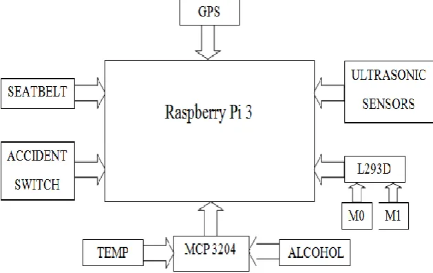
The architecture of the proposed framework is shown in figure 1.It has Raspberry PI microcontroller module, which is connected to server module and the web application module.
ISSN(Online): 2319-8753 ISSN (Print): 2347-6710
I
nternational
J
ournal of
I
nnovative
R
esearch in
S
cience,
E
ngineering and
T
echnology
(An ISO 3297: 2007 Certified Organization) Website: www.ijirset.com
Vol. 6, Issue 7, July 2017
Microcontroller module is utilized to gather information about potholes and humps and their geographical locations and this information is sent to the server. Server module receives information from the microcontroller module, processes and stores in the database. Web application module uses information stored in the server database and provides timely alerts to the driver.
Seatbelt, accident switch, Alcohol, temperature sensors used for vehicle automation. Measurement of temperature sensor, detection sensor, seatbelt sensor, accident switch and the sensed-data includes pothole, hump, and geographic location, is stored in the Google spread sheet. An Android application is used to alert drivers so that precautionary measures can be taken to evade accidents.
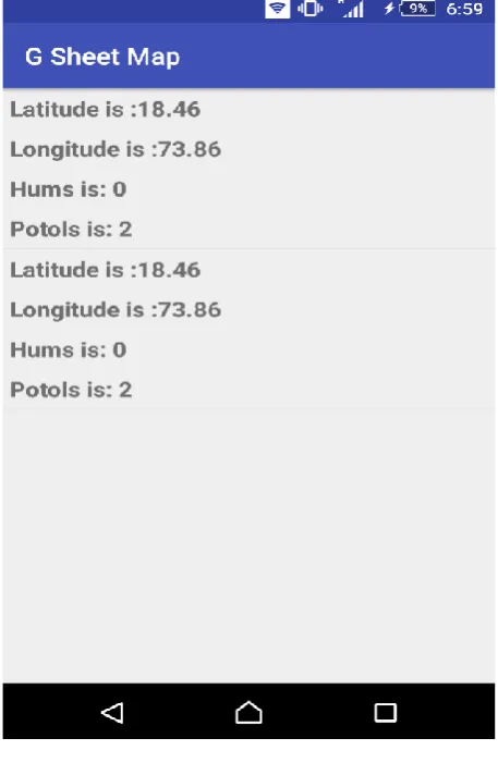
GUI of Smartphone -
Figure 2 show the GUI of Smartphone. G sheet map android application is made. Application is used to find the location from Google spreadsheet. If the location is matched, to display numbers of potholes and humps.
Figure 2: GUI of Smartphone
B. SOFTWARE
ISSN(Online): 2319-8753 ISSN (Print): 2347-6710
I
nternational
J
ournal of
I
nnovative
R
esearch in
S
cience,
E
ngineering and
T
echnology
(An ISO 3297: 2007 Certified Organization) Website: www.ijirset.com
Vol. 6, Issue 7, July 2017
purpose programming language.An HTML editor is a computer program for editing HTML, the markup of a webpage. Although the HTML markup of a web page can be written with any text editor, specialized HTML editors can offer convenience and added functionality.
Figure: 3 Flowchart of Proposed System
Potholes and humps are detected by the using ultrasonic sensor. These detected values of potholes and humps are updated on Google spread sheet with the no of humps and potholes with their location through GPS.
Android application used in the smartphone will search for the location which was recently updated on the Google spread sheet if location found by the application then display on the application itself.
IV.RESULT
ISSN(Online): 2319-8753 ISSN (Print): 2347-6710
I
nternational
J
ournal of
I
nnovative
R
esearch in
S
cience,
E
ngineering and
T
echnology
(An ISO 3297: 2007 Certified Organization) Website: www.ijirset.com
Vol. 6, Issue 7, July 2017
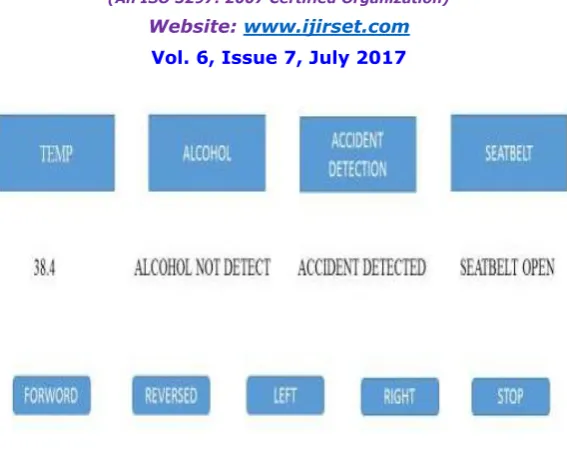
Figure: 4 GUI of Vehicle
Table 1 -Information about Potholes and humps Collected Test Environment
Sr Latitude Longitude location Potholes Humps
1 18.45489 73.82322 Narhe 6 5
2 18.44221 73.80958 Dhayari 7 4
3 18.44229 73.76709 Khadakawasa
la
4 3
4 18.50739 73.80765 Kothrud 8 4
5 18.46753 73.86774 Katraj 5 6
6 8.50183 73.86359 Swarget 3 7
7 18.53082 73.84746 Shivajinagar 9 2
ISSN(Online): 2319-8753 ISSN (Print): 2347-6710
I
nternational
J
ournal of
I
nnovative
R
esearch in
S
cience,
E
ngineering and
T
echnology
(An ISO 3297: 2007 Certified Organization) Website: www.ijirset.com
Vol. 6, Issue 7, July 2017
Figure: 5Narhe GPS location and no of potholes and humps detected
Android application show figure 5is used for showing the number of potholes and humps of respective location. When open the Android application first search location on Google spread sheet if location match then shows the value of potholes and humps. In this diagram location and no of potholes and humps are shown.
ISSN(Online): 2319-8753 ISSN (Print): 2347-6710
I
nternational
J
ournal of
I
nnovative
R
esearch in
S
cience,
E
ngineering and
T
echnology
(An ISO 3297: 2007 Certified Organization) Website: www.ijirset.com
Vol. 6, Issue 7, July 2017
Table no 2 show confusion matrix of potholes. Analysis is done for 100 potholes.
Table 2 - Confusion Matrix of Potholes
Potholes Detected Non Detected
Show potholes 48 2
Non show potholes
3 47
Table no 3 show confusion matrix of humps. Analysis is done for 80 potholes.
Table 3 - Confusion Matrix of Humps
Humps Detected Non Detected
Show humps 39 1
Non show humps 4 36
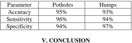
Table no 4 show percentage analysis of confusion matrix of potholes and humps.
Table 4 - Analysis of potholes and Humps
Parameter Potholes Humps
Accuracy 95% 93%
Sensitivity 96% 94%
Specificity 94% 97%
V. CONCLUSION
The system was developed and tested to serve two important purposes, Automatic detection of potholes and humps and alerting vehicle drivers to evade potential accidents. The proposed approach is an economic solution for detection of dreadful potholes and uneven humps, as it uses low cost ultrasonic sensors. The mobile application used in this system is an additional advantage as it provides timely alerts about potholes and humps. The solution also works in rainy season when potholes are filled with muddy water as alerts are produced utilizing the data put away in the database. We have tested for different location having different no of potholes and humps. The parameter values of the developed system are accuracy 95% sensitivity 96% and specificity 94% for potholes. Similarly accuracy 93% sensitivity 97% and specificity 90% for humps was obtained. Future implemented using camera we can take picture of potholes and humps. We can increase accuracy further by camera. We can implement Location of potholes and speed breakers alongside their co-ordinates can be detected by using vibration based approach. We can improve performance of this system by increasing area and by increasing number of locations.
REFERENCES
[1] ShambhuHegde,Harish V. Mekaliand GollaVaraprasad“Pothole Detection and Inter Vehicular Communication” inProc. IEEE Int. Conf. Vehicular Electron., 2014. PP 84-87.
[2] IonutSchiopu, Jukka P. Saarinen, LauriKettunen, and IoanTabus “Pothole Detection and Tracking in Car Video Sequence,” vol.13, no.5, June 2015, PP 701-706.
[3] VinayRishiwal and Hamshan Khan “Automatic Pothole and Speed Breaker Detection using Android System,” vol.17, no.7, April 2014, PP 1270-1273.
ISSN(Online): 2319-8753 ISSN (Print): 2347-6710
I
nternational
J
ournal of
I
nnovative
R
esearch in
S
cience,
E
ngineering and
T
echnology
(An ISO 3297: 2007 Certified Organization) Website: www.ijirset.com
Vol. 6, Issue 7, July 2017
[5] Z. Zhang, X. Ai, C. K. Chan, and N. Dahnoun, “An efficient algorithm for pothole detection using stereo vision,” in Proc. IEEE Int. Conf.Acoust., Speech Signal Process., May 2014, PP 564-68.